Earthquakes around the world

Ground deformation (bulging) continues on #Reykjanes Peninsula in #Island 🇮🇸
City of #Grindavík under access ban from Monday 15 at 19:00 hrs. There is now an increased risk of new cracks. The possibility of a new eruption continues
#Iceland

Seismic swarm north of #Grindavik and #Hagafell on #Reykjanes Peninsula #Island 🇮🇸
Chance of a new #eruption increases.
#Iceland #Svartsengi #Earthquake

Moments ago, roughly 2/3 of Grindavik lost power in the middle of their evacuation due to the ongoing earthquake swarm. #Iceland Source: youtube.com/watch?v=goSxiI…
 
Last week saw 1 M7 a M7.5 and a M6, a M6.2m both of which happened in Japan.
In the usual area, there was 1 out of 127 earthquakes worldwide equal to or greater than 4.5 and 1388 out of 1726 quakes of all sizes.
Percentage: 80.4%
Last week saw 2 M6 earthquakes with the highest being a M6.7 in the Philippines.
In the usual area, there were 2 out of 79 quakes worldwide equal to or greater than 4.5 and 1282 out of 1541 quakes of all sizes.
Percentage: 83.2%
Earthquakes 7 days to Jan 14th 2024.gif
 
WORLDWIDE EARTHQUAKE REPORT JANUARY 14_2024

Low levels of seismic activity occurred in the past 24 hours.

The total number of earthquakes recorded in the last 24 has increased to 1479 which is above the normal range of activity. This was mainly due to the strong seismic activity recorded in the volcanoes Reykjanes with 572 events and Fagradalsfjall with 141 events in Iceland.​
Lava from fissural eruption in #Reykjanes #Island 🇮🇸 burning and consuming homes and buildings in #Grindavik #Iceland city.
Photo credits go to Ragnara Xelsson, photographing the Arctic for over 40 years.
Lava from one of the fissures reaches and sets fire to a building in the city of #Grindavik in #Reykjanes #Iceland. January 14, 2024​
Shocking images of new #fissural #eruption in #Island. Lava from one of the new fissures reaches the city of #Grindavik in #Reykjanes #Iceland. Via @mondoterremoti​
Clear Lake (26 quakes between mag 0.2-2.1) Eldey (16 quakes between mag 0.6-2.4) Fagradalsfjall (141 quakes between mag 0.1-2.8), Kilauea (10 quakes between mag 1.8-2.6), Okataina (Tarawera) (12 quakes between mag 1.5-2.5), Reykjanes (572 quakes between mag 0.1-3.5)

Iceland volcano - latest: ‘Black day’ for Grindavik as houses torched and farm animals at risk from lava​

It has been a “black day” for the town of Grindavik, Iceland’s prime minister has said after lava from a volcanic eruption hit the small fishing town and torched multiple houses.

Katrín Jakobsdóttir called for calm and urged residents to stick together and look out for one another.

She said: “Today is a black day for Grindavík and today is a black day for all of Iceland, but the sun will rise again.

“Together we will deal with this shock and whatever may come. Our thoughts and prayers are with you.”

Multiple houses have been set on fire from the lava. Residents have been evacuated and there were reports of injury or death, although some farm animals were not able to be moved.

The strongest volcano earthquake occurred in Akita-Yake-yama located in the Honshu Island, Japan with a magnitude 3.8​
quakes-at-volcanoes-14012024.jpg

Recent quakes worldwide map shows the distribution of the last 20 large earthquakes.
earthquakes-latest.jpg

● M 5.2 - 26 km WNW of Ollagüe, Chile
2024-01-14 01:08:13 (UTC)
21.141°S 68.493°W. 126.7 km depth
USGS earthquake alert
chrome_screenshot_14 ene. 2024 15_37_23 GMT-06_00.png

● M 4.9 - 4 km W of Fonte Bastardo, Portugal
2024-01-14 08:19:55 (UTC)
38.694°N 27.128°W. 10.0 km depth
USGS earthquake alert
chrome_screenshot_14 ene. 2024 15_40_14 GMT-06_00.png

Other light earthquakes occurred in Houma, Tonga (M4.5) Yacuiba, Bolivia (M4.7) Sarangani, Philippines (M4.6) Fiji region (M4.5) central Mid-Atlantic Ridge (M4.9)

● Summary

Seismic activity has been at low levels in the last 24 hours. This is the last chart posted by Volcanodiscovery at 23:16 UTC on January 14 Global seismic activity chart
seismic-activity-level.png
In the past 24 hours, there were 1479 quakes of magnitudes up to 5.2
  • 1 quake above magnitude 5
  • 24 quakes between magnitude 4 and 5
  • 128 quakes between magnitude 3 and 4
  • 327 quakes between magnitude 2 and 3
  • 999 quakes below magnitude 2 that people normally don't feel.
Jan. 10 - 894 eqHighest record
Jan. 11 - 927 eqJan. 14 - 1479 eq
Jan. 12 - 967 eq
Jan. 13 - 800 eqHighest mag.
Jan. 14 - 1479 eqM7.5 Noto Japan

Estimated combined seismic energy release equivalent to 3293 tons of TNT or 0.2 atomic bombs
Volcanodiscovery
 
WORLDWIDE EARTHQUAKE REPORT JANUARY 15_2024

Moderate levels of seismic activity occurred in the past 24 hours. An M5.4 earthquake shook the Kurumkan region of Russia. According to preliminary estimates from the US Geological Survey, the quake might have been felt by over 100,000 people, but no material or human damage is expected.

A seismic cluster of 4 earthquakes M5+ occurred in the southwestern Pacific Ocean, between the islands of Vanuatu and northeastern New Zealand. These earthquakes could be a significant event in the region.

The total number of earthquakes recorded in the last 24 has increased to 957 which is above the normal range of activity. According to Volcano earthquake report volcano earthquake swarm occurred in:​
Clear Lake (38 quakes between mag 0.2-1.9),
Fagradalsfjall (14 quakes between mag 0.1-1.5) Reykjanes (124 quakes between mag 0.1-1.8)
The strongest volcano earthquake occurred in Gagak volcano with a M3.1 the volcano is located 10km from Bogor Regency, West Java.
quakes-at-volcanoes-15012024.jpg
Recent quakes worldwide map shows the distribution of the last 20 large earthquakes.
1705361386328.png

● M 5.4 - 68 km NW of Kurumkan, Russia
2024-01-15 12:52:26 (UTC)
54.809°N 109.651°E. 10.0 km depth
USGS earthquake alert
chrome_screenshot_15 ene. 2024 16_31_36 GMT-06_00.png

● M5.3 Chile Bolivia border region
Jan 15, 2024 01:08:12 UTC
21.02°S / 68.29°W. 112.3 km depth
OBSIS earthquake report
chrome_screenshot_15 ene. 2024 17_23_30 GMT-06_00.png

● M 5.0 - 5 km ENE of San Pedro de Atacama, Chile
2024-01-15 05:17:38 (UTC)
22.897°S 68.146°W. 105.8 km depth
USGS earthquake alert
chrome_screenshot_15 ene. 2024 16_29_06 GMT-06_00.png

● M 5.1 - Bouvet Island region (South Africa)
2024-01-15 17:30:27 (UTC)
53.876°S 3.044°E. 15.8 km depth
USGS earthquake alert
chrome_screenshot_15 ene. 2024 16_35_52 GMT-06_00.png

● M5.3 - South Pacific Ocean, 296 km northeast of Sunday Island, New Zealand
Jan 15, 2024 12:16:10 UTC
27.9387°S / 175.3024°W. 33 km depth
GEONET earthquake alert

● M 5.1 - Kermadec Islands, New Zealand
2024-01-15 21:56:59 (UTC)
30.668°S 178.013°W. 34.8 km depth
USGS earthquake alert

● M 5.1 - 107 km NNW of Isangel, Vanuatu
2024-01-15 16:43:06 (UTC)
18.692°S 168.784°E. 141.1 km depth
USGS earthquake alert

● M 5.0 - 168 km S of ‘Ohonua, Tonga
2024-01-15 00:50:53 (UTC)
22.858°S 175.077°W. 10.0 km depth
USGS earthquake alert
chrome_screenshot_15 ene. 2024 16_40_07 GMT-06_00.png

Other light earthquakes occurred in Ambon, Indonesia (M4.6) Hinatuan, Philippines (M4.9) Sarangani, Philippines (M4.9) El Aguilar, Argentina (M4.5) Antofagasta de la Sierra Chile (M4.8) San Clemente California (M4.4) Oaxaca Mexico (M4.0, M4.0) Guerrero Mexico (M4.1, M4.0)

● Summary

Seismic activity has been at low levels in the last 24 hours. This is the last chart posted by Volcanodiscovery at 22:52 UTC on January 15 Global seismic activity chart
seismic-activity-level.png

In the past 24 hours, there were 957 quakes of magnitudes up to 5.4
  • 8 quakes above magnitude 5
  • 29 quakes between magnitude 4 and 5
  • 93 quakes between magnitude 3 and 4
  • 231 quakes between magnitude 2 and 3
  • 596 quakes below magnitude 2 that people normally don't feel.
Jan. 11 - 927 eqHighest record
Jan. 12 - 967 eqJan. 14 - 1479 eq
Jan. 13 - 800 eq
Jan. 14 - 1479 eqHighest mag.
Jan. 15 - 957 eqM7.5 Noto Japan

Estimated combined seismic energy release equivalent to 9730 tons of TNT or 0.6 atomic bombs
Volcanodiscovery
 

Attachments

  • chrome_screenshot_15 ene. 2024 16_40_07 GMT-06_00.png
    chrome_screenshot_15 ene. 2024 16_40_07 GMT-06_00.png
    253.3 KB · Views: 1
WORLDWIDE EARTHQUAKE REPORT JANUARY 16_2024

Low levels of seismic activity occurred in the past 24 hours. M5.0 earthquake in Fiji region adds to southwest Pacific seismic clustering. The M5.0 earthquake in the Fiji region occurred at a considerable depth of 581 km.

According to Meteorological Research Institute of Tokyo: "The geographical distribution of deep earthquakes is limited to several deep earthquake regions, namely, Japan and its vicinity, the southwest Pacific Ocean, Central and South America, and Hindu Kush. Among them, the most active region of very deep earthquakes has been and still is the Fiji-Tonga-Kermadec region in the southwest Pacific Ocean."
chrome_screenshot_15 ene. 2024 16_40_07 GMT-06_00.png

Energy from the M7.5 Noto Japan earthquake continues its path and has been released twice in southern Greece. The latest quake had a magnitude 5.0 in the Mirtoan Sea at a shallow depth of 28.9 km. This region should be monitored for more significant events.

The total number of earthquakes recorded in the last 24 has increased to 852 which is within the normal range of activity. According to Volcano earthquake report volcano earthquake swarm occurred in:​
Clear Lake (32 quakes between mag 0.3-1.5), Reykjanes (54 quakes between mag 0.1-1.8)​
quakes-at-volcanoes-16012024.jpg

The strongest volcano earthquake occurred in Agung Volcano with a M3.6 the volcano is located 22 km northwest of Amlapura, Karangasem Regency, Bali, Indonesia.

Recent quakes worldwide map shows the distribution of the last 20 large earthquakes.​
earthquakes-latest.jpg

● M 5.1 - 132 km E of Bitung, Indonesia
2024-01-16 18:03:51 (UTC)
1.345°N 126.318°E. 31.6 km depth
USGS earthquake alert
chrome_screenshot_16 ene. 2024 17_03_33 GMT-06_00.png

● M 5.0 - 11 km NNE of Leonídio, Greece
2024-01-16 05:20:53 (UTC)
37.261°N 22.899°E. 28.9 km depth
USGS earthquake alert
chrome_screenshot_16 ene. 2024 13_06_00 GMT-06_00.png


● M 5.0 - 16 km WSW of Anamizu, Japan
2024-01-16 09:42:16 (UTC)
37.196°N 136.726°E. 10.0 km depth
USGS earthquake alert
chrome_screenshot_16 ene. 2024 16_56_16 GMT-06_00.png

● M 5.0 - Fiji region
2024-01-16 09:48:42 (UTC)
21.632°S 179.337°W. 581.0 km depth
USGS earthquake alert
chrome_screenshot_16 ene. 2024 18_01_10 GMT-06_00.png

Other light earthquakes occurred in Teller, Alaska (M4.5) Hengchun, Taiwan (M4.8) Kuril’sk, Russia (M4.5) Pedasí, Panama (M4.4) Longaví, Chile (M4.2) Dompu, Indonesia (M4.5) Oaxaca Mexico (M4.0, M4.0 M4.1)​

● Summary

Seismic activity has been at low levels in the last 24 hours. This is the last chart posted by Volcanodiscovery at 22:52 UTC on January 16 Global seismic activity chart
seismic-activity-level.png
In the past 24 hours, there were 852 quakes of magnitudes up to 5.1
  • 4 quakes above magnitude 5
  • 30 quakes between magnitude 4 and 5
  • 104 quakes between magnitude 3 and 4
  • 266 quakes between magnitude 2 and 3
  • 448 quakes below magnitude 2 that people normally don't feel.
Jan. 12 - 967 eqHighest record
Jan. 13 - 800 eqJan. 14 - 1479 eq
Jan. 14 - 1479 eq
Jan. 15 - 957 eqHighest mag.
Jan. 16 - 851 eq M7.5 Noto Japan

Estimated combined seismic energy release equivalent to 3652 tons of TNT or 0.2 atomic bombs.
Volcanodiscovery
 
WORLDWIDE EARTHQUAKE REPORT JANUARY 17_2024

Moderate levels of seismic activity occurred in the past 24 hours. An M5.6 quake hit Hinatuan Philippines and this is an aftershock of the M7.6 quake last Dec. 2.
chrome_screenshot_17 ene. 2024 18_09_40 GMT-06_00.png

The total number of earthquakes recorded in the last 24 has increased to 922 which is above the normal range of activity. According to Volcano earthquake report volcano earthquake swarm occurred in:
Clear Lake (37 quakes between mag 0.3-2.3), Fagradalsfjall (14 quakes between mag 0.5-1.4), Reykjanes (21 quakes between mag 0.2-1.4)
The strongest volcano earthquake occurred in Cumbres with a M4.3 located 20 km northeast of Ciudad Serdan, Mexico.
Other strong volcano earthquake occurred in Bárðarbunga volcano 3.4 Km ESE of Bárðarbunga Iceland​

quakes-at-volcanoes-17012024.jpg

Recent quakes worldwide map shows the distribution of the last 20 large earthquakes.
earthquakes-latest.jpg

● M 5.6 - 26 km NE of Hinatuan, Philippines
2024-01-17 12:32:02 (UTC)
8.546°N 126.498°E. 51.4 km depth
USGS earthquake alert
chrome_screenshot_17 ene. 2024 18_09_40 GMT-06_00.png

M 5.1 - southeast central Pacific Ocean
2024-01-17 21:34:10 (UTC)
29.007°S 94.163°W. 10.0 km depth
USGS earthquake alert
chrome_screenshot_17 ene. 2024 18_15_01 GMT-06_00.png

● M 5.0 - 218 km N of Saipan, Northern Mariana Islands
2024-01-17 13:00:48 (UTC)
17.176°N 145.977°E. 143.1 km depth
USGS earthquake alert
chrome_screenshot_17 ene. 2024 18_11_38 GMT-06_00.png

Other light earthquakes occurred in Baukau, Timor Leste (M4.7) Yuma, Dominican (M4.0) Meulaboh, Indonesia (M4.7) Gorontalo, Indonesia (M4.5) Abepura, Indonesia (M4.9) La Tirana, Chile (M4.4) Ohonua, Tonga (M4.9) Veracruz Mexico (M4.5) Puebla Mexico (M4.3) Chiapas Mexico (M4.0)​

● Summary

Seismic activity has been at moderate levels in the last 24 hours. This is the last chart posted by Volcanodiscovery at 23:35 UTC on January 17 Global seismic activity chart
seismic-activity-level.png
In the past 24 hours, there were 922 quakes of magnitudes up to 5.6
  • 3 quakes above magnitude 5
  • 20 quakes between magnitude 4 and 5
  • 101 quakes between magnitude 3 and 4
  • 250 quakes between magnitude 2 and 3
  • 548 quakes below magnitude 2 that people normally don't feel.
Jan. 13 - 800 eq Highest record
Jan. 14 - 1479 eq Jan. 14 - 1479 eq
Jan. 15 - 957 eq
Jan. 16 - 851 eq Highest mag.
Jan. 17 - 922 eqM7.5 Noto Japan

Estimated combined seismic energy release equivalent to 6862 tons of TNT or 0.4 atomic bombs
Volcanodiscovery
 
Screenshot 2024-01-18 at 17-51-51 SkyAlert on X #SismoFinalizado Intensidad 🟠“FUERTE”🟠 en #Hua...png

#Earthquake magnitude 5.0 (SSN) located 35km southeast of Crucecita, #Oaxaca. Detected by @REDSkyAlert
with 'Strong' intensity in epicenter zone.
#ReporteSismo - This is what it looked like from #Huatulco on #sismo today in Oaxaca. At the moment no damage is reported.
@webcamsdemexico


WORLDWIDE EARTHQUAKE REPORT JANUARY 18_2024

High levels of seismic activity occurred in the past 24 hours. A M6.4 earthquake shook the Tonga region in the southwest Pacific Ocean. An event of such magnitude was to be expected due to the M5+ seismic clustering that occurred in previous days. There is a relationship between seismic clustering and significant M6+ events.​
A seismic cluster of 4 earthquakes M5+ occurred in the southwestern Pacific Ocean, between the islands of Vanuatu and northeastern New Zealand. These earthquakes could be a significant event in the region.
chrome_screenshot_15 ene. 2024 16_40_07 GMT-06_00.png
The epicenter was located about 126 km (78 miles) NW of Fangale’ounga, and 126 km (78 miles) WSW of Neiafu, Tonga. 21 000 people are estimated to have felt light shaking. The USGS issued a Green alert (low) for shaking-related fatalities and economic losses. The M6.4 earthquake was preceded by an M5.0 and an M5.8 earthquake.

M5.3 and M5.7 earthquakes shook the South Sandwich Islands. This seismic activity takes pressure off Chile, which so far has recorded light M4+ and M5+ activity.

On the morning of January 18, Mexican authorities recorded an M5.0 earthquake with epicenter 21 km southeast of Crucecita, Oaxaca, at 08:40 hours local time. Fortunately, the earthquake did not cause any damage.

An M4.7 earthquake struck at the top of the world. According to information from Volcanodiscovery: "The earthquake was the strongest to hit this part of Russia in over 6 years. Earlier, the last quake of equal or greater strength near the present epicenter had been a magnitude 4.8 earthquake on Tuesday, Jul 17, 2018"

The total number of earthquakes recorded in the last 24 has decreased to 838 which is within the normal range of activity. According to Volcano earthquake report volcano earthquake swarm occurred in:​

Campi Flegrei (Phlegrean Fields) (11 quakes between mag 0.1-1.3), Clear Lake (33 quakes between mag 0.2-1.7), Etna (8 quakes between mag 1.1-2.4), Krísuvík (20 quakes between mag 0.1-1.6), Reykjanes (22 quakes between mag 0.1-2.1)
The strongest volcano earthquake occurred in Cuernos de Negros volcano with a M3.0 located 16 km west of Dumaguete City, Philippines.​
quakes-at-volcanoes-18012024.jpg
Recent quakes worldwide map shows the distribution of the last 20 large earthquakes.​
earthquakes-latest.jpg

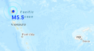
● M 6.4 - 125 km NW of Fangale’ounga, Tonga
2024-01-18 22:12:20 (UTC)
18.928°S 175.147°W. 218.1 km depth
USGS earthquake alert

● M 5.8 - 111 km WSW of Houma, Tonga
2024-01-18 04:50:01 (UTC)
21.652°S 176.250°W. 155.0 km depth
USGS earthquake alert

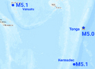
● M 5.0 - 126 km NE of Hihifo, Tonga
2024-01-18 16:13:35 (UTC)
15.230°S 172.880°W. 10.0 km depth
USGS earthquake alert
chrome_screenshot_18 ene. 2024 16_56_59 GMT-06_00.png

● M 5.7 - South Sandwich Islands region
2024-01-18 12:46:14 (UTC)
55.386°S 28.630°W. 23.4 km depth
USGS earthquake alert

● M 5.3 - South Sandwich Islands region
2024-01-18 05:12:14 (UTC)
59.663°S 26.412°W. 54.1 km depth
USGS earthquake alert
chrome_screenshot_18 ene. 2024 17_06_30 GMT-06_00.png

● M 5.2 - 92 km ENE of Poso, Indonesia
2024-01-18 17:36:20 (UTC)
1.114°S 121.533°E. 46.8 km depth
USGS earthquake alert
chrome_screenshot_18 ene. 2024 17_19_28 GMT-06_00.png

● M 5.1 - Philippine Sea, 99 km east of Bislig City, Philippines
Jan 18, 2024 15:57:34 UTC
8.51°N / 127.17°E. 38 km depth
GFZ earthquake alert
chrome_screenshot_18 ene. 2024 17_35_59 GMT-06_00.png

● M 5.0 - 11 km E of Santa María Zapotitlán, Mexico
2024-01-18 14:40:24 (UTC)
16.116°N 95.742°W. 46.9 km depth
USGS earthquake alert
chrome_screenshot_18 ene. 2024 17_16_33 GMT-06_00.png

● M 4.7 - north of Franz Josef Land
2024-01-18 06:15:45 (UTC)
86.513°N 67.419°E. 10.0 km depth
USGS earthquake alert
chrome_screenshot_18 ene. 2024 17_12_40 GMT-06_00.png

Other light earthquakes occurred in Bengkulu, Indonesia (M4.6) south of the Fiji Islands (M4.8) Labuan Bajo, Indonesia (M4.7) Poso, Indonesia (M4.6) Anamizu, Japan (M4.5) Çelikhan, Turkey (M4.1) Guerrero Mexico (M4.1, M4.0) Chiapas Mexico (M4.2)​

● Summary

Seismic activity has been at high levels in the last 24 hours. This is the last chart posted by Volcanodiscovery at 22:28 UTC on January 18 Global seismic activity chart
seismic-activity-level.png
In the past 24 hours, there were 838 quakes of magnitudes up to 6.4
  • 1 quake above magnitude 6
  • 7 quakes between magnitude 5 and 6
  • 22 quakes between magnitude 4 and 5
  • 93 quakes between magnitude 3 and 4
  • 253 quakes between magnitude 2 and 3
  • 462 quakes below magnitude 2 that people normally don't feel.
Jan. 14 - 1479 eqHighest record
Jan. 15 - 957 eqJan. 14 - 1479 eq
Jan. 16 - 851 eq
Jan. 17 - 922 eqHighest mag.
Jan. 18 - 838 eqM7.5 Noto Japan

Estimated combined seismic energy release equivalent to 78684 tons of TNT or 4.9 atomic bombs
Volcanodiscovery
 
Strong earthquake in Colombia

M 5.6 - 5 km SE of Cartago, Colombia
2024-01-19 11:26:03 (UTC)
4.719°N 75.871°W. 60.7 km depth
USGS earthquake alert

chrome_screenshot_19 ene. 2024 07_30_30 GMT-06_00.png

This earthquake was expected because of the energy distribution of the M7.5 earthquake in Noto, Japan earlier this year and the M6.7 earthquake in Sarangani Philippines on January 8. Signs of this appeared with the activity that occurred previously in Panama, Bolivia, Brazil, Ecuador and Argentina.
After yesterday's earthquakes in Panama, Bolivia and Brazil, it was the turn of Ecuador and Argentina. According to analyst Jesús Ramos, a M5+ earthquake could be expected in the region of Panama, Colombia, the coasts of Ecuador and northern Peru, and in the worst case, M6 low

"#Earthquake in #Colombia 🇨🇴 M5.6 today Jan. 19 at 6:26 am.
Images of how they lived the quake in a live news program in the city of #Cali.
#earthquake #earthquake
Via @radiosupercali"

#Colombia 🇨🇴 Damage reported from #earthquake in La Virginia, Risaralda.
Photos: Adrian Felipe Pelaez
 

It continues to shake in the border triangle of Bavaria - Tyrol - Salzburg: The fourth major earthquake at 8:28 p.m., this time again with a magnitude of 3.3. Noticeable from Kitzbühel to Lake Chiemsee.
Screenshot 2024-01-19 at 21-07-20 Erdbebennews on X Weiteres Erdbeben in Tirol mit Magnitude 3...png

People affected

The 3.4 earthquake occurred on 19 October. January, 3:30 p.m. Central European Time near the village of Sankt Ulrich am Pillersee, Austria. Earthquake news calculates a maximum intensity of 4.3 for this earthquake. Up to 138k people (in the map section) have felt this earthquake. 138k of these live in regions with slight or moderate shocks, where no significant damage is to be expected. 0 people live where damage to buildings may occur, 0 of them in areas with possible severe damage and destruction.

Intensity234
People affected115k23k425

Intensity levelPeople affectedImpact
2 – 5.5138kNoticeable suspension
5.5 – 6.50 0Slight damage
6.5 – 80 0Moderate damages
8 – 100 0Severe damages

What happened?

Update 20:57
ZAMG has revised the earthquake upwards to magnitude 3.5 in the evening. This makes it the strongest earthquake in the series to date. It is to be expected that further soon earthquakes will occur in the coming days.

Update 20:40
In the evening it trembled again: Magnitude 3.3 registered the Central Institute for Meteorology and Geodynamics around 8:30 p.m., thus as strong as the earthquake on Thursday morning. The vibrations were once again felt around the epicentre and also on the German side of the border.

Original message from 6:16 am

An earthquake series is built up in Tyrol. After two stronger earthquakes of magnitude 3.0 and 3.3 as well as several smaller ones in the last days, the next stronger earthquake followed in the night of Friday. According to ZAMG, this was again a little stronger with magnitude 3.4 and once again many people between Kitzbühel and Pillersee might have torn out of sleep. Similar to the earthquake on Thursday, almost exactly 24 hours before, the Schütter area also extended beyond the German border and included in addition to places close to the border such as Reit im Winkl, the southern shore of the Chiemse as well as Ruhpolding and parts of the Inn Valley, but only with very weak vibrations, which were probably only felt by individuals.

At the epicenter, the intensity was significantly higher than in the previous quee. In addition to the small difference in magnitude, the lower depth also contributed to the fact that intensities over IV have now been achieved. Minor damage to plaster (Haarrisse) can no longer be ruled out, since very locally higher intensities are also possible, depending on the exact location. Other earthquakes have to be expected. In addition to the usual aftersettings in the size range up to magnitude 2.5, further stronger earthquakes cannot be ruled out.

In Tyrol and the neighbouring Bavarian Alps there are always slight earthquakes. Due to the continuous growth of the Alps, there are some active disturbances along which shifts within the mountains. Most of these are small earthquakes. In historical times, however, there were also major earthquakes or partly via magnitude 6.

Affected towns, locations


CityCountryIntensity (EMS-98)ResidentsDistance epicentre (km)Description
Sankt Ulrich am PillerseeAT3.918004.1slightly notice
ErpfendorfAT3.611006.0slightly notice
WaidringAT3.620004.6slightly notice
Kirchdorf in TyrolAT3.628006.4slightly notice
Sankt Johann in TirolAT3.494008.6slightly notice
KitzbühelAT2.6830015.5barely noticeable
Saalfelden am Steinernen MeerAT2.01680027.6barely noticeable
KufsteinAT2.0980027.6barely noticeable
SiegsdorfDE1.9820031.5not felt
Prien am ChiemseeDE1.91090036.7not felt

Current earthquake activity near Sankt Ulrich am Pillersee:

In the past 30 days, 2 earthquakes over magnitude 2.7 have been registered in Sankt Ulrich am Pillersee (map section). This means that earthquake activity last month was significantly higher there than in a long-term comparison (over 20 percent deviation).

Summary of earthquake data:​

Earthquake measurement in the living room: Professional seismometers for experts and laypersons (sponsed)

General information about this earthquake:


Time / Time (CET): 19. January, 3:30 a.m.
Magnitude: 3.4
Depth: 4 km
Noticeable / Felt: yes
Damage expected / Damage expected: --
Victims expected / Casualties expected: --
Origin / Origin: tectonic Tsunami : --


Sources (earthquake services) on all earthquake data / List of global earthquake surveys

See also: The most complete compilation of earthquake losses and casualties: Earthquake Impact Database

Did you feel this earthquake? Please share your observation (display form)

Earthquake data: ZAMG

Statistics:

No statistics available because there is currently not enough data available.

Overview of the strongest earthquakes in the map section

DateMagnitudeDepth (km)
17.11.19894.512
29.10.20034.05 5
* Data: USGS catalogue (since 1960)

Note: The earthquake catalogue contains natural earthquakes. This includes some blasts and explosions. Thus, individual “false” earthquakes are possible in the representation. The magnitudes indication of individual earthquakes can also vary due to catalog differences.


WORLDWIDE EARTHQUAKE REPORT JANUARY 19_2024

Moderate levels of seismic activity occurred in the past 24 hours. South America had moderate to strong seismic activity. An M5.6 earthquake shook Colombia leaving numerous damages while further to the northeast an M5.3 earthquake struck Venezuela and another M5.1 Argentina. So far Peru has registered light activity, the highest magnitude quake reached 4.8

The Vanuatu region was shaken by two earthquakes, one magnitude 5.5 and the other magnitude 5.0 in response to the M6.4 earthquake in Tonga yesterday. This energy will continue to impact South America in the coming days possibly with M5+ or in the worst case M6+ low.

The total number of earthquakes recorded in the last 24 has increased to 840 which is within the normal range of activity. According to Volcano earthquake report volcano earthquake swarm occurred in:​
Clear Lake (28 quakes between mag 0.2-2.1) Tjörnes Fracture Zone (9 quakes between mag 1.1-2.4)
The strongest volcano earthquake occurred Escanaba Segment volcano with a Mag. 3.3 Earthquake 265 Km W of Ferndale, California

quakes-at-volcanoes-19012024.jpg
Recent quakes worldwide map shows the distribution of the last 20 large earthquakes. A light earthquake occurred in Greece with magnitude 4.5. In the map we see how the energy is being distributed from the region of Japan to the Mediterranean, where we have not seen a significant earthquake in recent months.​
1705707320133.png

● M 5.6 - 5 km SE of Cartago, Colombia
2024-01-19 11:26:03 (UTC)
4.719°N 75.871°W. 60.7 km depth
USGS earthquake alert
chrome_screenshot_19 ene. 2024 07_30_30 GMT-06_00.png


● M 5.5 - 89 km WNW of Sola, Vanuatu
2024-01-19 04:57:15 (UTC)
13.568°S 166.782°E. 45.9 km depth
USGS earthquake alert

● M 5.0 - 103 km NNW of Isangel, Vanuatu
2024-01-19 08:49:01 (UTC)
18.691°S 168.869°E. 10.6 km depth
USGS earthquake alert
chrome_screenshot_19 ene. 2024 19_09_33 GMT-06_00.png

● M 5.3 - 4 km SW of Salcha, Alaska
2024-01-19 21:34:35 (UTC)
64.497°N 146.968°W. 7.2 km depth
USGS earthquake alert
chrome_screenshot_19 ene. 2024 19_39_52 GMT-06_00.png

● M 5.3 - 92 km south of Valle de La Pascua, Venezuela
Jan 19, 2024 04:31:44 UTC
8.441°N / 65.705°W. 5.0 km depth
Volcanodiscovery earthquake report
chrome_screenshot_19 ene. 2024 19_50_32 GMT-06_00.png

● M 5.1 - 144 km NNW of Antofagasta de la Sierra, Argentina
2024-01-19 09:40:58 (UTC)
24.784°S 67.694°W 103.4 km depth
USGS earthquake alert
chrome_screenshot_19 ene. 2024 19_14_54 GMT-06_00.png

● M 4.5 - 12 km ENE of Oxílithos, Greece
2024-01-19 14:14:15 (UTC)
38.609°N 24.255°E. 10.0 km depth
USGS earthquake alert
chrome_screenshot_19 ene. 2024 19_33_41 GMT-06_00.png

Other light earthquakes occurred in Hasaki, Japan (M4.5) Port Blair, India (M4.8) Madrigal, Peru (M4.8) Pravda, Russia (M5.6) Bingtuan Sanshiliu Tuan China (M4.6) Bowangshan, China (M4.5) Qaraçala, Azerbaijan (M4.8) Guerrero Mexico (M4.0, M4.0) Oaxaca Mexico (M4.0, M4.0) Guatemala (M4.0) Chiapas Mexico (M4.0)​

● Summary

Seismic activity has been at moderate levels in the last 24 hours. This is the last chart posted by Volcanodiscovery at 23:25 UTC on January 19 Global seismic activity chart
seismic-activity-level.png
In the past 24 hours, there were 840 quakes of magnitudes up to 5.6
  • 6 quakes above magnitude 5
  • 34 quakes between magnitude 4 and 5
  • 88 quakes between magnitude 3 and 4
  • 244 quakes between magnitude 2 and 3
  • 468 quakes below magnitude 2 that people normally don't feel.
Jan. 15 - 957 eqHighest record
Jan. 16 - 851 eqJan. 14 - 1479 eq
Jan. 17 - 922 eq
Jan. 18 - 838 eqHighest mag.
Jan. 19 - 840 eqM7.5 Noto Japan

Estimated combined seismic energy release equivalent to 12770 tons of TNT or 0.8 atomic bombs
Volcanodiscovery
 

Attachments

  • chrome_screenshot_19 ene. 2024 19_09_33 GMT-06_00.png
    chrome_screenshot_19 ene. 2024 19_09_33 GMT-06_00.png
    205.3 KB · Views: 1
WORLDWIDE EARTHQUAKE REPORT JANUARY 20_2023

High levels of seismic activity occurred in the past 24 hours. Three powerful earthquakes occurred in the last hours: Brazil (M6.5) Southwest Indian Ridge (M6.3) and Pagan region, northern Mariana Islands (M6.1).

The earthquake in Brazil occurred 134 km from Cruzeiro do Sul in the Brazilian Amazon jungle at a considerable depth of 629 km, which is why the quake was felt only slightly in nearby towns. According to USGS the quake should not have caused any significant damage, but was probably felt by many people as light vibration in the area of the epicenter mainly in Tarauaca (pop. 16,500) located 122 km from the epicenter.

chrome_screenshot_20 ene. 2024 17_48_22 GMT-06_00.png

This earthquake in Brazil almost at the border with Peru may mark the end of the sequence that started with the M7.5 earthquake in Noto Japan and continued with the M6.7 in the Philippines, the M6.4 in Tonga region, the M6.1 in the Mariana Islands and the M6.3 in the southwestern Indian Ocean. If this is the case, let's wait for the next significant event. (Although M5+ events in Peru and Chile cannot be ruled out yet) Possibly a report from SSGEOS can give us an idea of when we could expect such an event given the planetary geometries, however so far their page has not been updated.

The total number of earthquakes recorded in the last 24 has increased to 952 which is above the normal range of activity. According to Volcano earthquake report volcano earthquake swarm occurred in:​
Clear Lake (21 quakes between mag 0.5-1.8), Fagradalsfjall (6 quakes between mag 0.2-1.3) Krísuvík (6 quakes between mag 0.4-1.4), Reykjanes (13 quakes between mag 0.1-1.1)
The strongest volcano earthquake occurred in Tenorio Volcano with Mag. 2.8. at 35 km SE of San José, provincia de Alajuela Costa Rica.​
quakes-at-volcanoes-20012024.jpg

Recent quakes worldwide map shows the distribution of the last 20 large earthquakes. There is a light to moderate concentration of energy in the western Pacific Ocean. The Vanuatu-Tonga-Kermadec region is still active and is targeted to be a candidate for a significant M7+ event.​
1705793306655.png

● M 6.5 - 123 km NW of Tarauacá, Brazil
2024-01-20 21:31:07 (UTC)
7.319°S 71.506°W. 628.8 km depth
USGS earthquake alert
chrome_screenshot_20 ene. 2024 15_47_46 GMT-06_00.png

● M 6.3 - Southwest Indian Ridge
2024-01-20 22:09:40 (UTC)
39.921°S 46.120°E. 10.0 km depth
USGS earthquake alert
chrome_screenshot_20 ene. 2024 16_56_30 GMT-06_00.png

● M 6.1 - Pagan region, Northern Mariana Islands
2024-01-20 15:48:40 (UTC)
18.526°N 145.535°E. 184.0 km depth
USGS earthquake alert
chrome_screenshot_20 ene. 2024 12_02_43 GMT-06_00.png

● M 5.2 - 291 km ESE of Vao, New Caledonia
2024-01-20 05:20:19 (UTC)
23.748°S 170.095°E. 10.0 km depth
USGS earthquake alert
chrome_screenshot_20 ene. 2024 16_10_52 GMT-06_00.png

● M 5.0 - 286 km SSE of Port Blair, India
2024-01-20 01:36:11 (UTC)
9.403°N 94.027°E. 10.0 km depth
USGS earthquake alert
chrome_screenshot_20 ene. 2024 16_05_38 GMT-06_00.png

● M 5.0 - South Sandwich Islands region
2024-01-20 04:54:05 (UTC)
59.893°S 26.354°W. 45.4 km depth
USGS earthquake alert

Other light earthquakes occurred in Angoram, Papua New Guinea (M4.7) Reykjanes Ridge (M4.8) Bagalangit, Philippines (M4.8) Mariana Islands region (M4.8) Miyakojima, Japan (M4.5)

● Summary

Seismic activity has been at high levels in the last 24 hours. This is the last chart posted by Volcanodiscovery at 23:15 UTC on January 20 Global seismic activity chart.
seismic-activity-level.png
In the past 24 hours, there were 952 quakes of magnitudes up to 6.5
  • 3 quakes above magnitude 6
  • 3 quakes between magnitude 5 and 6
  • 25 quakes between magnitude 4 and 5
  • 86 quakes between magnitude 3 and 4
  • 245 quakes between magnitude 2 and 3
  • 590 quakes below magnitude 2 that people normally don't feel.
Jan. 16 - 851 eqHighest record
Jan. 17 - 922 eqJan. 14 - 1479 eq
Jan. 18 - 838 eq
Jan. 19 - 840 eqHighest mag.
Jan. 20 - 952 eqM7.5 Noto Japan

Estimated combined seismic energy release equivalent to 163 gigawatt hours, equivalent to 1.4 x 10⁵ tons of TNT or 8.8 atomic bombs.
Volcanodiscovery
 
Back
Top Bottom