You are using an out of date browser. It may not display this or other websites correctly.
You should upgrade or use an alternative browser.
You should upgrade or use an alternative browser.
Atlantis
- Thread starter shijing
- Start date
mkrnhr said:It is strange that this article doesn't cite the french newspaper where the images are supposed to have been released.
The images seem to come from some TV program!
The images are attributed to Herald de Paris, a worldwide news website.
Here's a link to the Herald de Paris article about those pyramids.
There is this huge, city-like structure on the Atlantic seafloor in Google maps:
http://maps.google.com/?ie=UTF8&t=h&ll=31.522361,-24.477539&spn=4.293184,5.916138&z=7
It doesn't look like an image artifact and interestingly, it is located just southeast of the "Atlantis Seamount" on the mid-Atlantic ridge.
http://maps.google.com/?ie=UTF8&t=h&ll=31.522361,-24.477539&spn=4.293184,5.916138&z=7
It doesn't look like an image artifact and interestingly, it is located just southeast of the "Atlantis Seamount" on the mid-Atlantic ridge.
axj said:There is this huge, city-like structure on the Atlantic seafloor in Google maps:
http://maps.google.com/?ie=UTF8&t=h&ll=31.522361,-24.477539&spn=4.293184,5.916138&z=7
It doesn't look like an image artifact and interestingly, it is located just southeast of the "Atlantis Seamount" on the mid-Atlantic ridge.
The rectangular (almost square) shape is peculiar. I can think of a number of explanations for parallel lines, but can't think of any for parallel lines and then more parallel lines at right angles to the first ones forming a geometric structure.
Maybe someone can find some data on this area? I found the following:
The sedimentation pattern around the Atlantis-Meteor seamount complex: a model study
J. Verhoefa
Vening Meinesz Laboratorium, Budapestlaan 4,
P.O. Box 80.021, 3508 TA Utrecht The Netherlands
Received 28 February 1984;
accepted 30 October 1984.
Available online 23 October 2002.
Abstract
The Atlantis-Meteor seamount group forms a large volcanic complex situated about 700 km to the south of the Azores. Not counting the turbidite sedimentation of the Madeira abyssal plain to the east, the area around the complex is characterized by a relatively thick sedimentary layer containing a strong and often shielding reflector. The thickness of the sediments above the strong reflector, as well as the total sediment thickness, shows an asymmetry with respect to the seamount complex: west of the seamounts a thick sedimentary cover can be found, while virtually no sediments occur to the east of the seamounts.
The depth anomaly in the area around the seamount complex is positive. The depth anomaly contours correlate well with the regional isopachs of the sediment above the strong reflector. This correlation led to the construction of a simple carbonate sedimentation model. In this model paleodepth reconstructions were used to calculate the carbonate sedimentation. The model explains the most important aspects of the sedimentation pattern. Besides it led to the conclusion that the age of the strongly reflecting layer cannot be much older than Miocene.
This conclusion is sustained by the absence of sediments in the southwestern part of the area. Therefore it is unlikely that the volcanism in this area and the anomalous depth originated on the spreading centre. The model is not sensitive enough to detect variations in age between the different seamounts.
Since there are no DSDP sites in this area the age determination based on the sedimentation pattern forms a useful alternative for the time being.
Earth and Planetary Science Letters
Volume 73, Issue 1, April 1985, Pages 117-128
and this:
Great Meteor Seamount
From Wikipedia, the free encyclopedia
Location
Location North Atlantic Ocean
Coordinates 29°57′10.6″N 28°35′31.3″W / 29.952944°N 28.592028°W / 29.952944; -28.592028Coordinates: 29°57′10.6″N 28°35′31.3″W / 29.952944°N 28.592028°W / 29.952944; -28.592028
Geology
Type Guyot
Volcanic arc/chain
Great Meteor Seamount chain
The Great Meteor Seamount is a gigantic guyot located south of the Azores in the Atlantic Ocean. It is the New England hotspot's most recent eruptive center and is one of the most completely investigated seamounts in the world. This guyot rises up from a depth of almost 4,800 meters to about 270 meters below the surface of the Atlantic. It is flanked by the smaller Little Meteor Seamount.[1]
Formation
The New England hotspot formed the White Mountains 124 to 100 million years ago when the North American continent was directly overhead. As the continent drifted to the west, the hotspot gradually moved offshore. On a southeasterly course, the hotspot formed Bear Seamount, the oldest in the chain, about 100 to 103 million years ago. Over the course of millions of years, it continued creating the rest of the seamounts, eventually culminating in the Nashville Seamount about 83 million years ago. As the Atlantic Ocean continued to spread, the hotspot eventually "traveled" further east, forming the Great Meteor Seamount where it is found today.[2]
Ecology
The unique ecological condition of the Great Meteor Seamount is shown by the many endemic copepod and nematode species.[3]
References
1. ^ METEOR Retrieved on 2007-10-04
http://www.horta.uac.pt/projectos/marbef/DSOORS/FinalFiles/Meteor.pdf
2. ^ "Geological Origin of the New England Seamount Chain". National Oceanic and Atmospheric Administration. U.S. Department of Commerce. 2005. http://www.oceanexplorer.noaa.gov/explorations/03mountains/background/geology/geology.html. Retrieved 2007-07-31.
3. ^ SPOTLIGHT 5 Great Meteor Seamount - http://www.tos.org/oceanography/issues/issue_archive/issue_pdfs/23_1/23-1_mohn.pdf
Interesting Google photo, especially when known: 90 degree angle is not nature pattern, so if not done by nature....,...
Found couple promissing articles related to the same:
from: http://www.agu.org/pubs/crossref/1990/JB095iB11p17555.shtml
Quote: JOURNAL OF GEOPHYSICAL RESEARCH, VOL. 95, NO. B11, PP. 17,555-17,569, 1990
doi:10.1029/JB095iB11p17555
Evidence for Age and Evolution of Corner Seamounts and Great Meteor Seamount Chain From Multibeam Bathymetry
Brian E. Tucholke
Woods Hole Oceanographic Institution, Woods Hole, Massachusetts
N. Christian Smoot
U. S. Naval Oceanographic Office, Stennis Space Center, Mississippi
The Comer seamounts in the western North Atlantic and Great Meteor seamount “chain” in the eastern North Atlantic are thought to progress in age from Late Cretaceous through late Cenozoic. They both presumably formed by volcanism above the New England hotspot when first the North American plate, and then the Mid-Atlantic Ridge axis and African plate, moved over the hotspot. High-resolution, multibeam bathymetry of the seamounts shows geomorphic features such as guyots, terraces, and a base level plateau (Cruiser plateau) that we interpret to have formed at sea level. We have backtracked these features to sea level along the North Atlantic crustal age-depth curve in order to estimate their ages. The derived age pattern of volcanism indicates formation of the Comer seamounts at ca. 80 Ma to 76 Ma, with migration of the Mid-Atlantic Ridge plate boundary over the hotspot and formation of the Cruiser plateau about 76 Ma. Seamount ages suggest that subsequent volcanism on the African plate moved first northward, in the Late Cretaceous to early Cenozoic (Plato, Tyro, and Atlantis seamount groups), then southward to Great Meteor Seamount in the late Cenozoic. Recurrent volcanism appears to have occurred at some seamounts up to 20–30 m.y. after their initial passage over the hotspot. It would thus appear that intralithospheric conduits can link the hotspot to old seamounts several hundred kilometers away. End Quote
Although, this research was concentrated mostly on Azzores seamount area, the most important fact is posibility that todays sea mounts are FORMATED at sea level and than submurged.
In last 60 years Atlantic ocean and it's sea mounts were scanned in numerous occasions and lot of interesting material was written about this thematic:
Seabed cores taken from the mid-Atlantic Ridge in 1957 brought up freshwater plants from a depth of two miles. And in one of the deep valleys, known as Romanche, sands have been found that appear to have been formed by weathering when that part of the ridge was above water level. In a 1969 a Duke University research expedition dredged 50 sites along an underwater ridge running from Venezuela to the Virgin Islands, and brought up granitic rocks, which are normally found only on continents. Commenting on this discovery, Dr. Bruce Heezen of the Lamont Geological Observatory said:
"Up to now, geologists generally believed that light granitic or acid igneous rocks are confined to the continents and that the crust of the earth beneath the sea is composed of heavier, dark-colored basaltic rock... Thus, the occurrence of light-colored granitic rocks may support an old theory that a continent formerly existed in the region of the eastern Caribbean and that these rocks may represent the core of a subsided, lost continent."
A recent report on the nature of the Atlantic seabed appears to confirm that there is at least part of a former continent lying beneath the ocean. Under the heading "Concrete Evidence for Atlantis?" the British Journal New Scientist of June 5, 1975 reported, "Although they make no such fanciful claim from their results as to have discovered the mythical mid-Atlantic landmass, an international group of oceanographers has now convincingly confirmed preliminary findings that a sunken block of continent lies in the middle of the Atlantic Ocean. The discovery comes from analyzing dredge samples taken along the line of the Vema offset fault, a long east-west fracture zone lying between Africa and South America close to latitude 11º "N".
The report goes on to state that in 1971 two researchers from the University of Miami recovered some shallow-water limestone fragments from deep water in the area. Minerals in the limestone indicated that they came from a nearby source of granite that was unlikely to occur on the ocean floor. More exhaustive analysis of the dredge samples revealed that the limestones included traces of shallow-water fossils, implying formation in very shallow water indeed, a view confirmed by the ratios of oxygen and carbon isotopes found in the fragments. One piece of limestone was pitted and showed evidence of tidal action.
The researchers believe that the limestone dates from the Mesozoic era (between 70 and 220 million years ago) and forms a cap "on a residual continental block left behind as the Atlantic spread out into an ocean." the New Scientist observes that
"The granitic minerals could thus have come from the bordering continents while the ocean was still in it infancy. Vertical movements made by the block appear to have raised it above sea level at some period during it's history.
It would therefore seem that there is a lost continent in the Atlantic, but unfortunately for Atlantists, it evidently disappeared long before man appeared on earth. Most scientist remain convinced that there is no likelihood of finding the Atlantis described by Plato in the area of the mid-Atlantic Ridge. As L. Sprague de Camp comments in his Lost Continents, nearly all of the ridge, except for the small and mountainous Azores region, is under two or three miles of water, "and there is no known way to get a large island down to that depth in anything like the 10,000 years required to fit in with Plato's date for the sinking of Atlantis." He also points to a report published in 1967 by Dr. Maurice Ewing of Columbia University, who announced that "after 13 years of exploring the mid-Atlantic Ridge, he had "found no trace of sunken cities."
The bed of the Atlantic is, after all, an unstable are and one that has given birth to numerous islands, then swallowed them up again. In 1811, for example, volcanic activity in the Azores resulted in the emergence of a new island called Sammrina, which shortly sank back again into the sea. In our own time, the island of Surtsey, 20 miles southwest of Iceland, has slowly risen from the ocean. Surtsey was formed during a continuous underwater eruption between 1963 and 1966.
In 1948 Dr. Ewing, one of the bitter opponents of Atlantis, sailed up and down the Mid-Atlantic Ridge during the Woods Hole Oceanographic Expeditions to the Mid-Atlantic Ridge. Numerous samples of tremolite asbestos were brought up. Ewing made this significant comment: "Such rock is generally considered typical of continents and not of ocean basins." (Ewing, 1948) Important also was the discovery of "beachlike terraces" beneath two miles of ocean water. Ewing cautiously observed: "It is, of course, extremely radical speculation to identify these level stretches more than two miles below the sea surface as former beaches. Such a theory would require the obvious but almost incredible conclusion that the land has subsided two miles or else the sea has risen by that amount" (Ewing, 1948). However, subsequent expeditions only strengthened the "incredible".
According to Ewing, long flat stretches were detected 2 to 20 miles wide and hundreds of miles long. These beach-like areas were always covered with thick sediments, indicating a long period of deposition, although occasionally separated by mountainous "higher ground" exhibiting no such sediments. (The Central Highland of the Ridge occasionally approaches four-fifths of a mile from the sea surface.) Ewing observed that deep ocean basins never have thick sediments--which are the result of surf action and river deposition--it is actually shorelines that display thick sediments. More evidence of just how recently such a landmass existed turned up during an expedition the following year.
The follow-up expedition in 1949 turned up numerous core samples from these terraces. These cores contained two different strata of beach sand: the older estimated to be 225,000-325,000 years of age, and the younger 20,000-100,000 years old (Ewing, 1949). Another significant fact is that the deposits were found to be well-sorted by surf action into the usual pattern of shoreline beaches familiar to geologists (Miller & Scholten, 1966). His conclusion was that: "Sometime in the distant past this sand found deep beneath the ocean must have been located on a beach, at or near the surface of the sea" (Ewing, 1949).
During this second Woods Hole Mid-Atlantic Ridge Expedition Dr. Ewing once again dredged up continental type rocks. Sample after sample containing large masses of sial were brought up all along the Mid-Atlantic Ridge. It became obvious that granite and sedimentary rocks "which originally must have been part of a continent" were abundant (Ewing, 1949). Dr. Bruce Heezen observed that this type of rock indicates "possible sunken land masses".
Geologists have short memories when it comes to Atlantis. A geologist reviewed the Woods Hole expeditions of 1948-1949 barely ten years later and wrote a report on the findings (Cifelli, 1970). I read his report, word for word and cover to cover: not a word was written concerning the numerous findings of continental material (sial) along the Mid-Atlantic Ridge. Dr. Ewing was puzzled, even dismayed, by these particular discoveries; yet he was honest enough to report them. Why were these astounding facts not included in Richard Cifelli's review? Can professional geologists be this one-sided?
Still another oceanographic expedition, Swedish Deep-Sea Expedition of 1947-1948, yielded core samples containing sand from the Romache Deep along the Mid-Atlantic Ridge. Dr. Otto Mellis did not publish these findings until ten years later (Mellis, 1958). Other geologists have guardedly admitted that the Azore Islands (Central Atlantic) are composed chiefly of continental material, some even conceding that there might be enough continental material (sial) in the mid-Atlantic to make up a landmass the size of Spain (de Camp, 1970).
Direct Evidence of An Emergent Atlantis/Prof. MacKenzie Keith (Now Deceased)
Incidental, almost, to Keith’s efforts to buttress one of his points about a former emergent continent in the Atlantic ocean is the material that he summarizes on former shallow water or emergent sites sampled by the Deep Sea Drilling Project (DSDP). The sampling sites are currently underwater in the region of the Mid-Atlantic Ridge (MAR). Locations for three of these sites (Keith, 2001, Table 1) are shown by large red dots on Figure 6, a relief map of the Azores region we have used in previous articles on THC’s website. The red dots are rather large because, while the sampling coordinates that are listed give degrees north latitude, they do not give degrees west longitude. It is understood, however, that the samples were taken in the vicinity of the MAR axial valley, clearly visible on Figure 6.
Here’s what was found at point A, at a depth of 12,802 ft: highly vesicular basalt, weathered and oxidized basalt, and a major gap in the basal sedimentary section that indicates subaerial erosion. At site B, at a depth of 12,440 ft, basaltic pebbles and weathered and oxidized basalt were found. And at site C, in 12,313 ft of water, once again basaltic pebbles and weathered and oxidized basalt were found. All of the above findings are strong indicators of a formerly emerged MAR. And they suggest that this volcanic terrain has sunk a minimum of 12,300 ft since being exposed to the atmosphere. Note that Keith’s Table 1 lists six additional MAR sampling sites-to the south of those plotted on our Figure 6 and on down to the equator. Two of these sampling sites show ridge tops flattened by wave erosion, one revealed Tertiary-age shallow water sediment, and another revealed Cretaceous-age shallow water sediment. A final, rather startling finding consists of canyons and a trellis drainage system, quite possibly formed subaerially at a depth greater than 9800 ft. The MAR location is between 26º and 27ºN.
Fig. 6. Physiographic diagram of the Azores region, based on a diagram by B. Heezen and M. Tharp. See text for an explanation of red dots A-C, sites of deep-water sampling of subaerial material representative of an emergent continent. (Subaerial refers to conditions and processes that exist or operate in the open air on and immediately adjacent to a land surface). A repository for the records of the Atlantean civilization may be found in the area shown by blue shading. The Atlantean records repository will be found in a specific temple "where a portion of the temples may yet be discovered." (See Cayce reading 440-5).
As quoted from Keith (p. 266), additional evidence of former exposure of the MAR consists of
“…extensive denudation of oceanic crust [and] development of deep canyons and trellis drainage patterns along fault scarps of the MAR (Tucholke et al., 1997). Tucholke et al. attributed the modified topography to sub-ocean mass wasting but erosional features … out to about 300 km [185 miles] from the axis, favor Recent subaerial exposure and erosion of the ridge crest. Former broader subaerial exposure, and progressive subsidence, is indicated by borehole intersections at off-axis sites….The stratigraphy of those borehole sections provides evidence of broad exposure of the ridge followed by ridge subsidence, [and] narrowing of the active volcanic zone….” (Keith, p. 266).
http://www.huttoncommentaries.com/ECNews/Atlan_Mu/new_hypothesis.htm
Evidence from the floor of the ocean
In a 1954 issue of Geological Society of America, Bulletin, Bruce Heezen and others reported on a seamount - an underwater mountain - that has been named Atlantis by geologists and is in the Atlantic Ocean. It has been found to have been an island about 12,000 years ago - exactly the time specified by Plato! This abstract is given:
The Atlantis, Cruiser, and Great Meteor seamounts rise from a broad ridge or plateau which extends from the Mid-Atlantic Ridge to 37°N. 32°W. southeast to Great Sea mount at 30°N. 28°W. The Atlantis Sea mount, briefly explored 1947 and 1948, was found by echo sounding and submarine photography to have a fairly flat bedrock summit area at about 180 fathoms covered in some cases by current-rippled sand. Its slopes are covered with sand or ooze symmetrically rippled at 400 fathoms and marked by slump features in 570 fathoms. A small piece of volcanic agglomerate was dredged from 400 fathoms on the north slope. About a ton of flat pteropod limestone cobbles was dredged from the summit area. One of the cobbles gave an apparent radiocarbon age of 12,000 years ±900 (J.L. Kulp). The state of lithification of the limestone suggests that it may have been lithified under subaerial [i.e. above water, on land surface] conditions and that the sea mount may have been an island within the past 12,000 years. (Heezen, Bruce C., et al, "Flat-Topped Atlantis, Cruiser, And Great Meteor Sea Mounts" in Geological Society of America, Bulletin, 65:1261, 1954 (Protogonos issue 9))
In later studies, evidence was found for the remnants of a "sunken block of continent" in the middle of the Atlantic Ocean. An articlein New Scientist 1975 summarizes the result. (Anonymous, New Scientist,66:540, 1975)
Although they make no such fanciful claim from their results as to have discovered the mythical mid-Atlantic landmass, an international group of oceanographers has now convincingly confirmed preliminary findings that a sunken block of continent lies in the middle of the Atlantic Ocean. The discovery comes from analysing dredge samples taken along the line of the Vema offset fault, a long east-west fracture zone lying between Africa and South America close to latitude 11øN.
The article describes the first report of "shallow-water limestone fragments" from the Vema Fracture in the Atlantic:
Four years ago two University of Miami workers, J. Honnorez and E. Bonatti, first reported the recovery of shallow-water limestone fragments from the Vema fracture zone. This limestone contained minerals indicative of a nearby granitic source unlikely to occur on the ocean floor. Neither water currents, nor more esoteric transport systems, could explain the presence of these rocks so far from the modern boundaries of the continents. The two researchers believed that, instead, the granitic grains must have been deposited close to their source.
Then the recent researchers are noted:
Now, with C. Emiliani of Miami, Paul Bronniman of the University of Geneva, M.A. Furrer of Esso Production Research, Begles, and A.A. Meyerhof, a consulting geologist from Tulsa, USA, they have carried out a more searching analysis of the dredge samples (Earth and Planetary Science Letters, vol. 26, p.8)
Finally he notes the evidence for activity in less than 30 meters ofwater, and even some evidence for activity in soil.
The Limestones include traces of shallow-water fossils - foraminifera, green algae, bits of gastropods, and crab coprolites - implying formation in water, in one instance, less than 30 m deep. Furthermore, the limestones have been recrystallized from a high to low-magnesium form of calcite. Oxygen and carbon-isotope ratios prove conclusively that this process must have taken place subaerially [on land surface] "through the action of meteoric water enriched in light carbon while passing through a soil zone ..." A pitted limestone sample bears evidence of tidal action. Some 50 km east of the dredge site along the Vema fracture the team also recovered a thick-shelled, shallow-water, bivalve fossil from a depth of over 2000 m.
The coprolites in the sample indicate a Mesozoic age for the limestone which may well be the sedimentary capping on a residual continental block left behind as the [??] spread out into an ocean. The granitic minerals could thus have come from the bordering continents while the ocean was still in its infancy. Vertical movements made by the block appear to have raised it above sea level at some period during its history.
(from Unknown Earth: A Handbook of Geological Enigmas by William R. Corliss.)
http://www.atlantissource.com/home/forgotten_article.htm
PROOF OF THE FORMER EXISTANCE OF A
LARGE ISLAND ON THE MID ATLANTIC RIDGE
River Systems Extract - Azores as a Large Island
In 1971 we carried out an inspection of parts of the South Coast of San Miguel, the largest of the Azorean Islands. At one point, we found the remnants of a large, boulder filled, river-bed truncated by the shoreline. The rounded boulders were smoothly water-worn and massive (up to two feet across). The river bed, if we remember correctly, was some two hundred and fifty feet from bank to bank; but there was now insufficient width of island to sustain such a river. The boulders were so worn that they had, obviously, travelled a considerable distance, and a strong current of water with a head of thousands of feet would have been required to transport them. There was no room on the narrow island for such a current to be fostered - the rivers source must have lain to the north, on the flanks of a high mountain range. The present mountains on San Miguel are only a little over 3,000 feet high; and we estimate that it would have required a fall of at least 10,000 feet to have reduced boulders of that size, and hardness, to the degree of roundness which they profess.
This discovery so intrigued us that we started an investigation of the mapped sea-bed around all of the islands, with remarkable results. We started with the 1:1 million scale Admiralty Chart - Arquipelago dos Acores - the numerous soundings of which gave a very good general view of the configuration of the sea bed over the whole group of Azorean islands, covering, from east to west - Ilheus das Formigas, Santa Maria, Sao Miguel, Terciera, Soa Jrge, Graciosa, Pico (with its 7,613 feet high, conical, volcanic peak). These were supplemented by larger scale charts where they were available.
We started by contouring the sea bed at intervals of 100 fathoms (600 feet), and it immediately became clear that the river systems that now modestly drain the southern flanks of Sao Miguel were merely head-water tributaries whose channels continued far out to sea, joining into one great, winding, submarine valley some 40 miles further to the south. Other islands contributed similar results and, outstanding, were the triple group of Fial, Sao Jorge and Terciera whose combined results spawned two long river-like valleys which joined into one large valley to give a system that extended for 180 miles.
The whole of the Azorean island group was separated and surrounded by a net of submarine valleys that had all the hall-marks of having once been river valley's on the surface. The Azores could - and probably had, within comparatively recent times - sunk by many thousands of feet.
The next step was to decide whether it was possible to detect any particular contours which might point to an ancient shore line pre dating the sinking of the area. In the south, there was a clear break in gradients around the 1,900 fathom (11,400 feet) contour where a very extensive plain dipped sharply into deeper water. In the north, much the same had happened but at a considerably more shallow depth.
It began to look as if a large land mass, 450 miles across from east to west, and 300 miles from north to south, had tilted from north to south and had sunk beneath the waves, leaving only its mountain peaks showing above the waters - peaks which now form the ten islands of the Azores.
After further calculation, we reached the conclusion that the tilting, either before or during foundering, had been of the order of 0.4 degrees, as a result of which the south coast had sunk more than 11,000 feet and the north coast only some 6,000 feet.
We then reconstructed the land profiles to the approximate positions in
which they should have been before the catastrophe. We re-contoured the whole area, raising the north coast by 6,000 feet; the south coast by 11,000 feet; and the intervening area proportionally to the adopted gradient. The result was the outline map shown below.
It was now possible to visualise a great island about the size and shape of Spain, with high mountain ranges rising over 12,000 feet above sea level and impressive rivers running in curving valley systems. In the southeast, a feature which we have called 'The Great Plain' covered an area in excess of 3,500 square miles, and was watered by a river comparable in size to the River Thames in England. It has, and we shall sea, points in common with the great plain described by Plato in his Critias, as being a feature of the Island of Atlantis.
The study on which we have embarked has two parts. The first is to establish that a large island could have existed in mid-Atlantic in Pre-historic times; the second is to determine whether there could have been a connection between the inhabitants of such an island and our heroes - The Shining Ones.
In our judgement, the first of these parts has been successfully determined; and it is proper, therefore, to proceed with an examination of Plato's detailed description of Atlantis and its inhabitants.
Extract from Chapter 18 The Shining Ones by Christian and Barbara Joy O'Brien
http://www.goldenageproject.org.uk/342proof.html
From time immemorial, the Atlantic Ridge from Iceland to South America has been an area of considerable seismic activity. Volcanic eruptions and earthquakes are nothing extraordinary.
The Atlantic Ocean – Catastrophes:
In 1669, a major part of the notorious pirate island Port Royal sank due to an disastrous earthquake.
In 1775, Lisbon, which is on a parallel with the Azores at a latitude of 39 43'/36 55' N, was badly hit by a devastating earthquake killing 60 000 people. Moreover, both the harbour and the docks sank 200 metres to the ground.
In 1783, one fifth of the Icelandic population fell victim to a catastrophic earthquake.
In 1811, on the Azores, a volcanic island named “Sambrina“ rose some thousand metres to the surface and sank again shortly after. The islands of Corvi and Flores constantly change their shape and parts of them are swallowed up by the sea.
To the best of present knowledge there is an underwater area with deep valleys and high mountains around the Azores and the Canary Islands. Reducing the sea level by 150 metres to the Ice Age level brings about a huge piece of land which, however, does not match the dimensions Plato wrote about. Nevertheless, further westward, in the Caribbean area, a huge land mass comes into existence which perfectly meets Platos records.
In 1969, by order of Duke University, an expedition to the Aves Ridge in the Caribbean Sea found granite on fifty locations. Usually, granite is found only onshore or where once had been solid ground.
In 1898, 750 km north of the Azores, the transatlantic cable broke. On this occasion, rock samples were taken from a depth of 17 000 fathoms. A close examination came to the result that the rock samples consisted of tachylyte, a lava-like substance. Yet this mineral would not emerge unless above sea level and under atmospheric pressure. Moreover, it will decompose after 15 000 years. This means that once there had been mainland.
In a depth of up to 1 000 metres, coastal sand was found on the reefs of the Azores. However, it usually only appears on flat beaches.
In 1936, the Geological Society of America conducted a study of sunken river canyons in the Atlantic Ocean. It says that rivers on the European, the North African and the American side sank into the continental sockets for up to 300 km in length and 2 km in depth. That means that in the Pleistocene Age, that is when mankind emerged, the sea level underwent a change in depth up to 2 000 metres.
THE ICE AGE & THE OCEANS
Sea-level changes and the Pleistocene Ice Age
Sea-level has been close to its present level for the past 6000 years, before which it was lower and fluctuating, last achieving its present position about 120,000 years ago. About 15,000-16,000 years ago, sea-level was 130-140 m below its present position. For the past 500,000 years it has been lower than today about 90% of the time.
These major changes coincide with the Ice Age. The last 1.65 million years of geological time -- the “Quaternary” -- is split into the Pleistocene and the Holocene epochs. The latter represents the last 10,000 years when most of the icesheets had melted.
Sea-level falls coincide with periods of glaciation whereas the rises occur during interglacials -- the warmer times between ice advances, like the present day and most of the Holocene.
The onset of the Ice Age began about 40 million years when surface waters in the southern oceans suddenly cooled and the deep ocean basins quickly filled with water ~10°C cooler than before that sank because of its increased density. By about 15 million years ago, the Antarctic Icecap had formed, accelerating production of cold waters. Consequently, siliceous diatom oozes became more abundant in the southern oceans because of increased upwelling that resulted from steeper temperature, and density, gradients.
About 6–5 million years ago, Miocene Epoch, sea-level fell by as much as 50 m, probably associated with expansion of the icecap in Antarctica. Termed the Messinian Event, this might have caused the Mediterranean Sea to dry up over ~1,000 years, producing vast salt deposits, preserved in the sediments of the sea floor.
About 5 million years ago there followed a brief warming trend and sea-level rose again leaving shallow marine sediments inland of modern coastlines around much of the world. Fossil floras and faunas show that climates were generally warmer than today -- Iceland had a temperate climate; southern England was subtropical.
Between 2 and 3 million years ago, ice caps began to form in the northern hemisphere.
During times of glacier growth, areas near glaciers experienced very cold conditions. Regions away from glaciers also experienced varied climates as climatic belts shifted. Because the world ocean temperatures became cooler, there was less evaporation; consequently, much of the world was drier than today. In contrast, some areas that are arid today were much wetter during times of glacial growth. For example, the temperate, sub-tropical and tropical zones were compressed toward the equator by the expanding cold belts – rain that now falls in the Mediterranean fell on the Sahara; the southwestern U.S. was wetter during glacial times because the high-pressure zone over the northern icecap deflected Pacific winter storms southward. Many salt lakes in the western US e.g., Great Salt Lake and Death Valley, were then flooded and greatly expanded.
Information on Quaternary climates comes from many sources – e.g., glacial features and deposits, pollen and sediments on the seafloor. The evidence from terrestrial deposits suggests that Pleistocene glaciation covered 27 million km2 or about three times the present area occupied by ice. The evidence from glacial deposits, mainly tills, in North America suggests at least four main glacial episodes, separated by warmer interglacials when the ice fronts melted back or retreated. In Europe, at least seven advances have been recognized. Part of the problem is that the advancing ice commonly erodes the deposits of earlier glaciations.
In the early 1960’s, Pleistocene ocean-floor sediments were examined for the first time for evidence of ice age climates. They showed that the glacial advances and retreats were far more complex than formerly believed. The evidence from the deep-sea oozes reflects changes in ocean temperatures and ocean water chemistry that can be related to climatic conditions.
The main evidence has come from fossil planktonic foraminifera on the ocean floor. Cores are recovered of the near surface sediments, which are then washed and sieved to concentrate the foraminifera shells = calcium carbonate. Some species are sensitive to warm or cold water, so by examining their distribution in a core, one can determine whether the overlying ocean water was warm or cool. Some species migrate to warmer waters when the ocean surface cools. For example, one species, Globorotalia menardii, is only found near the equator during cool glacial periods, but is found in higher latitudes during warmer interglacial periods.
Other planktonic foraminifera change their coiling direction in response to temperature fluctuations. The Pleistocene species, Globorotalia truncatulinoides coils to the right in water temperatures >10°C, while to the left in water <8-10°. Detailed climatic curves can be reconstructed from coiling ratios.
A widely used method is to measure the ratio of the isotopes 18O to 16O in the CaCO3 of planktonic foraminifera shells. Isotopes: all atoms of an element have the same number of protons in the nucleus, but may have different numbers of neutrons. Those having different numbers of neutrons are isotopes of the element: e.g., oxygen 16, oxygen 18.
The abundance of these two oxygen isotopes is related to the amount of oxygen in seawater when the shell is formed. The exact ratio of these two isotopes reflects the amount of ocean water stored in glacier ice. When water is evaporated from the oceans and precipitated on land to form glaciers, water containing the lighter 16O isotope is more easily evaporated than water containing the heavier 18O isotope. Consequently, Pleistocene glaciers contained more of the lighter isotope, while the oceans became enriched in the heavier isotope. These changes are recorded in the shells of planktonic foraminifera, which take up oxygen in their shells as calcium carbonate = CaCO3.
When the sediments have been dated by radiometric methods - radiocarbon dating and methods that data volcanic ash falls = the chronology of glacial and interglacial periods can be interpreted. Many more glacial/interglacial phases are suggested from the oceans than the records of glacial deposits on land. About 18 glacial expansions are recognized from deep-sea cores, increasing in intensity toward the latter part of the Pleistocene. Tying the sedimentary records from the oceans and land together, correlation, has proved difficult except for the youngest glacial periods . . .
http://www.usask.ca/geology/classes/geol206/iceoceans.html
Variability During the Last Ice Age: Dansgaard-Oeschger Events
Abrupt changes did not begin during the Younger Dryas. Throughout the last glacial period (60,000 to 20,000 years ago), abrupt warming and cooling events, called Dansgaard-Oeschger or D-O events occurred in the North Atlantic. Greenland ice core records reveal that during the last glacial, the climate system abruptly shifted into, and then back out of, warm, close-to-interglacial conditions 23 times. Each oscillation consisted of gradual cooling followed by an abrupt warming.
Related to some of the coldest D-O intervals were distinctive events, recorded in North Atlantic marine sediments, of changes in the delivery of icebergs to the ocean and the amount of ice-rafted sand transported southward by the icebergs.
These Heinrich events in the sediment record resulted from changes in ocean circulation and iceberg melting, and were clear indications that cold polar waters extended farther south, carrying ice-rafted material from northern regions ( Bond et al. 1992, Bond & Lotti 1995). The events may have been accompanied by an influx of freshwater into the North Atlantic, through increased melting. Scientists have hypothesized that reduced deepwater formation may have accompanied these dramatic, but temporary, shifts of the Earth's climate. This is currently an area of active research (Maslin et al. 1995).
Cariaco Basin Sediment and GISP2 Ice Core Comparisons
Figure 19a. Abrupt climate events called Dansgaard-Oeschger events are found in Greenland ice cores, and some other locations such as the Cariaco Basin in the Caribbean Sea. Warm (interstadial) events are numbered in the ice core (red). Less negative numbers in the oxygen isotope ratio indicate warmer conditions in Greenland. In the Cariaco Basin sediment cores (green), highly reflective sediment layers indicate light green mud, and signals ocean climate and circulation associated with low plankton productivity. The data are significant because they reveal ocean-wide climate changes occuring within a century or less, altering the temperatures in the far North Atlantic, and the sea surface conditions close to the equator. In both regions, conditions appear to flip back and forth between two different states.
More recently, Bond and colleagues (Bond et al. 2001) have correlated the events in the North Atlantic with changes in solar output (the latter derived from proxy records in ice cores and tree rings). Their conclusion is that small, gradual changes in solar output crossed thresholds in the climate system, and that changes in thermohaline circulation resulted in abrupt shifts in the Earth's climate system.
Like the Younger Dryas, these events have had a hemispheric to global footprint. They were seen in sediment cores off the coast of Africa (Zhao et al. 1995), off the coast of Venezuela (Peterson et al. 2000), in the Arabian Sea (Schulz et al. 1998), and in Hulu Cave in China (Wang et al. 2001). The magnitude of change outside the North Atlantic, and more generally the geographic extent of abrupt change in temperature and precipitation during the last glacial, are currently topics of intense research.
http://www.ncdc.noaa.gov/paleo/abrupt/data_glacial2.html
BTW, thanks Shijing, great work:)
combsbt
Jedi Master
axj said:There is this huge, city-like structure on the Atlantic seafloor in Google maps:
http://maps.google.com/?ie=UTF8&t=h&ll=31.522361,-24.477539&spn=4.293184,5.916138&z=7
It doesn't look like an image artifact and interestingly, it is located just southeast of the "Atlantis Seamount" on the mid-Atlantic ridge.
I remember this from a while ago, it was explained by Google as being an artifact:
http://www.telegraph.co.uk/news/newstopics/howaboutthat/4735793/Atlantis-was-blip-on-Google-Earth.html
google spokesperson said:"In this case, however, what users are seeing is an artefact of the data collection process.
"Sea floor terrain data is often collected from boats using sonar to take measurements of the sea floor.
"The lines reflect the path of the boat as it gathers the data.
vinny
The Living Force
Ask_a_debtor said:I remember this from a while ago, it was explained by Google as being an artifact:
google spokesperson said:"In this case, however, what users are seeing is an artefact of the data collection process.
"Sea floor terrain data is often collected from boats using sonar to take measurements of the sea floor.
"The lines reflect the path of the boat as it gathers the data.
... which sounds plausible. But then why are these artifacts not much more widespread?
Or it could be a lie: 'nothing to see here' ?
Or even anomalous data deliberately placed to keep us distracted, so we don't notice something else?
Nomad said:Ask_a_debtor said:I remember this from a while ago, it was explained by Google as being an artifact:
google spokesperson said:"In this case, however, what users are seeing is an artefact of the data collection process.
"Sea floor terrain data is often collected from boats using sonar to take measurements of the sea floor.
"The lines reflect the path of the boat as it gathers the data.
... which sounds plausible. But then why are these artifacts not much more widespread?
Or it could be a lie: 'nothing to see here' ?
Or even anomalous data deliberately placed to keep us distracted, so we don't notice something else?
Agree with you Nomad.
Related to the sonar errors, back in 1968, US navy allready had high sophisticated sonars deep towed side-scan, who could search deep ocean waters without the problem, with the same sonars they discovered the wreck of USS Scorpion (SSN 589) sunk nuclear submarine on a sandy seabed at the bottom of the Atlantic Ocean in approximately 3,000 m (9,800 ft) of water.
Some interferences on deep water sonars are still a mistery like the case back In 1986 a GLORIA (6.5 kHz) side-scan sonar survey from 4500m in the Bering Sea revealed an unexplained pattern of backscattering that was sub-parallel to track and similar to the pattern generated by the Lloyds mirror effect. In 1987 part of the previous years survey was repeated and the pattern reappeared in an almost identical fashion. It was concluded that the seafloor sediments were responsible. Since then the pattern has been observed on sediments from many of the world's oceans, and on sonographs from the Institute of Oceanographic Sciences deep towed side-scan (TOBI) which operates at 30 kHz. Several geometries have been considered for the formation of these interference fringes and those in the GLORIA experiments can be attributed to a layer of thickness 3-5 m, the nature of which is a subject of speculation.
later scinetists find following on the subject:
GLORIA side-scan sonographs from the Bering Sea Basin show a complex pattern of interference fringes sub-parallel to the ship's track. Surveys along the same trackline made in 1986 and 1987 show nearly identical patterns. It is concluded from this that the interference patterns are caused by features in the shallow subsurface rather than in the water column. The fringes are interpreted as a thin-layer interference effect that occurs when some of the sound reaching the seafloor passes through it and is reflected off a subsurface layer. The backscattered sound interferes (constructively or desctructively) with the reflected sound. Constructive/destructive interference occurs when the difference in the length of the two soundpaths is a whole/half multiple of GLORIA's 25 cm wavelength. Thus as range from the ship increases, sound moves in and out of phase causing bands of greater and lesser intensity on the GLORIA sonograph. Fluctuations (or lsquowigglesrsquo) of the fringes on the GLORIA sonographs relate to changes in layer thickness. In principle, a simple three dimensional image of the subsurface layer may be obtained using GLORIA and bathymetric data from adjacent (parallel) ship's tracks. These patterns have also been identified in images from two other systems; SeaMARC II (12 kHz) long-range sonar, and TOBI (30 kHz) deep-towed sonar. In these, and other cases world-wide, the fringes do not appear with the same persistence as those seen in the Bering Sea.
Regular sonars (used on fishing boats, cruisers, yachts....,...) in early days of development had issues with the ship own propulsion-propeler water jet, who made appearances like water is instantly from deep water becoming shallow, of course next generation of regular sonar didn't have this problem.
Differences between regular sonars used on boats and deep water sonars is in fact that regular sonar (no mater passive or active) is attached to the ship hull, deep water sonars, on other hand are towed behind the ship, this system is know by the name: side scan sonar, highly deep water sonars are so advanced that the best high resolution pictures are coming even from 2 ships towing sonars simultaneously like in case of: Two-Boat Shoot Technique for Deep-Water Route Surveys, or system known like: The SonarBell,that is a maintenance-free, passive sonar locator system that operates by focusing energy like a lens to amplify sound levels and reflect them to the sender. The system uses the two materials of its shell and core to create a constructive interference that delivers a higher return signal to the end user. The device is ‘solid state’ with no moving parts or power requirements, and is compatible with existing commercial sonar sets.
The most of earth under sea maps and scans are made with: High-Resolution Deepwater Survey Sonar, and this is technology back from 1984 (here is the article from the same year about the HRDSS):
As survey requirements moved into water depths greater than 2,500 meters, new technology was required to obtain high resolution geophysical data alone precise grid lines. This paper discusses a unique bottom referenced tow system that provides 100k Hz side scan and 3.5/7.O kHz sub bottom sonars; multiplexed over an 8,500 meter single coax tow cable. This design provides a stable towing platform that maintains a constant optimum height over the sea floor which requires minimum cable length 'alterations that affect the tow fish causing imperfections in the data. This system is meant to provide high quality, distortion-free mosiacs with uniform bottom and sub-bottom features recorded at a constant tow speed and height above the sea floor.
Because the towing concept is bottom referenced, the topographic features are lost as the tow fish flies over a high relief area at a constant height off the sea floor. With enhanced electronic techniques, combined with a depth sensor in the fish, the topographic detail of the sea floor is recorded on the sub-bottom record; thus, the survey packageprovides the complete high resolution record of the true sea floor and sub-bottom features with resolution and quality never achieved before.
Another important facet of this system is positioning of the tow fish. With 8,500 meters of cable out, it is imperative for record correlation to know where the tow fish is. A precise ultra-short baseline portioning system integrated with the tow fish telemeters the tow fish position back to the vessel. The position is then co-r-related to the vessel navigation system to allow position plotting along the survey grid.
INTRODUCTION
The offshore oil and gas industry is exploring for reservoirs in deep water exceeding 2,500 meters. As survey requirements move into these water depths, a new technology has been necessary to obtain high-resolution geophysical data of the sea floor. Improved techniques have been developed to acquire high-resolution, short-range side-scan sonar (100 kHz) and 3.5 or 7.0 kHz sub-bottom data in deep water environment. Extremely detailed records of the ocean floors geologic features have been gathered that compare to the data obtained in shallow water surveys.
Developments include the design of the deep-tow vehicle and associated electronics, special towing requirements, and navigation for precise positioning of deep-tow system. Also, a multiplex system was developed to provide for dataacquisition and control of electronics over long cable lengths.(Figure 1)
TECHNICAL REQUIREMENTS AND EQUIPMENT
The acquisition of high-resolution data in deep water requires attention to numerous aspects not normally encountered in shallow water surveys. Shallow or surface towed acoustic sources suffer from losses due to signal attenuation and beam spreading. These losses increase in severity with greater water depths.
Exquisite technique for deep water scans existed long before google existed, my question is: are they using photos of the sea floor from earlies 80' of last century, I doubt in that, their data seems to be from this century. So why should they point a finger in technology non plus ultra? Is it just a prank to play our minds or something else?
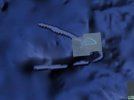
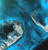
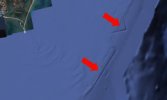
Although we don't know why such anomalies are shown on the google, if they are really just a glitch in scanning, and why these anomalies are not removed from the google earth, if THEY are scan mistakes. It would be nice to find out the truth about it.
Bathymetry is relatively new science but showing promising and intriguing results. One of sonar's archeology pioneers is scientist Paulina Zelitsky who found remarkable ruins close to the Cuba.
Quote from: http://www.s8int.com/water23.html
On May 28 2002, National Geographic News reported on the recent discovery of megalithic ruins some 2,200 ft. below sea level off the coast of Cuba. Interviewed for the story was geologist, Manuel Iturralde, Director of Research at Cuba’s Natural History Museum and consulting geologist for Canadian exploration company ADC, based in Havana, Cuba.
According to a 2001 Special Report by Gateway to Atlantis author Andrew Collins, "The discoveries were made last summer during deep-sea surveys made by Paulina and a trained scientific research team aboard the Cuban research vessel, Ulysses.
"Sonar images revealed `an extensive series of structures’ over a several-mile area in darker and lighter shades. The site is close to the edge of the underwater geological feature known as the Cuban shelf, which falls off sharply in a series of shelves which drop down to several thousand metres, and it is on one of these shelves, in around 600-700 metres of water, that the structures are to be found."
"`Whenever you find a volcano, there is often a settlement associated with it,’ Paul Weinzweig, Paulina’s husband and a director of ADC, observed. `I don’t know the exact relationship, but it is in the same vicinity as the volcano, the fault line and the river. They’re quite close to one another.’
"On the matter of whether the sonar imagery really does show `pyramids, roads and buildings`, Paul stated: `We had been looking at the images for some months, and keep a picture on the wall showing pyramids in the Yucatan, and let’s just say they kept reminding us of these structures. They really do look like an urban development.’"
Finding sunken cities, much less the fabled Atlantis, was not the main mission of ADC in Fidel Castro’s Cuba. Their original scientific operation was to survey the deep waters off the Cuban coastline as part of a joint venture set up between the Canadian company and the Cuban government, in particular its state partner Geomar.
One of their chief aims is to pinpoint the location of the billions of dollars of bullion and lost treasure from sunken ships dating back to the Conquest.
ADC’s husband and wife team are not the first to have laid claim to the discovery of sunken cities off the coast of Cuba.
There are unconfirmed reports that Soviet submarines discovered an underwater "building complex" during the 1960s.
Leicester Hemingway, brother of writer Ernest Hemingway claimed to have spotted, during a flight into the country, beyond its northern coast, "an expanse of stone ruins, several acres in area and apparently white, as if they were marble."
The exact location of this underwater marble city remains unclear. The Soviet submarine underwater "building complex" remains unconfirmed and there are no actual pictures of undersea objects in the ADC find.
But the ADC claim, if ever proven, like the Canadian architect’s claim of having found the Chinese boat that proves that the Chinese reached North America first, would change the course of world history.
"If Paulina Zelitsky and her oceanographic colleagues are right in their belief that `pyramids, roads and buildings’, do lie off Cuba’s western coastline, then it is clear that the prehistory of the Caribbean, and its influence on the rise of Mesoamerican civilization, will have to be revised dramatically," says Collins.
"Moreover, it could well be that at long last the mystery of Atlantis, mankind’s greatest historical enigma, is about to unfold in a most spectacular fashion."
End Quote
more on the subject on: http://www.timstouse.com/EarthHistory/Atlantis/bimini.htm
or on: http://news.nationalgeographic.com/news/2002/05/0528_020528_sunkencities.html
Some of the photos made by ROV on the same location were more than promissing.
Attachments
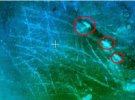


But underwater city close to the Cuban coast is not the only one recently revieled.
One of them is sunken city close to Indian Mahabalipuram.
Quote from: http://news.bbc.co.uk/2/hi/south_asia/1923794.stm
An ancient underwater city has been found off the coast of south-eastern India.
Map, BBC
Divers from India and England made the discovery based on the statements of local fishermen and the old Indian legend of the Seven Pagodas.
The ruins, which are off the coast of Mahabalipuram, cover many square kilometres.
A further expedition to the region is now being arranged which will take place at the beginning of 2003.
'International significance'
The discovery was made on 1 April by a joint team of divers from the Indian National Institute of Oceanography and the Scientific Exploration Society based in Dorset, UK.
Expedition leader Monty Halls said: "Our divers were presented with a series of structures that clearly showed man-made attributes.
The team had just three days to explore the site, SES/BBC
The expedition team want to return next year
"The scale of the site appears to be extremely extensive, with 50 dives conducted over a three-day period covering only a small area of the overall ruin field.
"This is plainly a discovery of international significance that demands further exploration and detailed investigation."
During the expedition to the site, divers came across structures believed to be man-made. One of the buildings appears to be a place of worship.
Jealous Gods
The myths of Mahabalipuram were first set down in writing by British traveller J Goldingham, who visited the South Indian coastal town in 1798, at which time it was known to sailors as the Seven Pagodas.
The myths speak of six temples submerged beneath the waves with the seventh temple still standing on the seashore.
One of the underwater buildings, SES/BBC
Structures are clearly visible in the murky waters
The myths also state that a large city which once stood on the site was so beautiful the gods became jealous and sent a flood that swallowed it up entirely in a single day.
One of the expedition team, Graham Hancock, said: "I have argued for many years that the world's flood myths deserve to be taken seriously, a view that most Western academics reject.
"But here in Mahabalipuram, we have proved the myths right and the academics wrong."
Scientists now want to explore the possibility that the city was submerged following the last Ice Age. If this proves correct, it would date the settlement at more than 5,000 years old.
End Quote
Attachments


Or:
February 16, 2002 Surat, India - A month ago in mid-January, marine scientists in India announced they had sonar images of square and rectangular shapes about 130 feet down off the northwestern coast of India in the Gulf of Khambhat (Cambay). Not only are their sonar shapes with 90-degree angles, the Indian Minister of Science and Technology ordered that the site be dredged. What was found has surprised archaeologists around the world and was the subject of a private meeting two weeks ago attended by the Indian Minister in charge of investigating the underwater site about thirty miles off the coast from Surat.
An American who traveled to that private meeting was Michael Cremo, researcher in the history of archaeology for the Bhakti Vedanta Institute in India and author of the book Forbidden Archaeology. I talked with him today in India about the dredging operation, what the ocean engineers found and the implications of first carbon dating of artifacts at more than 9,000 years.
Interview
Michael Cremo, Researcher of Ancient Archaeology and Author, Forbidden Archaeology: "Within the past few months, the engineers began some dredging operations there and they pulled up human fossil bones, fossil wood, stone tools, pieces of pottery and many other things that indicated that it indeed was a human habitation site that they had. And they were able to do more intensive sonar work there and were able to identify more structures. They appeared to have been laid out on the bank of a river that had been flowing from the Indian subcontinent out into that area.
According to the news releases, they have done a radiocarbon testing on a piece of wood from the underwater site that is now yielding an age of 9,500 years which would place it near the end of the last Ice Age.
Yes, those are the indications that are coming. There were actually two radiocarbon dates: one about 7500 years old and another about 9500 years old. The 9500 year old one seems to be the strongest one. That's the one they are going with. This was announced by Minister Joshi (Murli Manohar Joshi is Indian Minister for Ocean Technology) at this meeting I attended in Hyderabad, India. He said there is going to be more work going on. It's difficult because it's very difficult to see down there. There is a very swift current. So, it's going to have to be a pretty massive effort, but he said the government of India is willing to put the resources behind it to do whatever it takes to further confirm these discoveries.
I also spoke in Hyderabad with an independent archaeologist not connected with the Indian government, but who has a deep interest in these discoveries and he says they are still going to have to send divers down there. Up to this point, they have not sent divers down. The information they have is based on the sonar readings and the dredging they have done. Eventually, they are going to have to find a way to get people down there to take a closer look at this. I think this effort is going to go on.
Now, another American archaeologist, Richard Meadows of Harvard University, is proposing there should be an international effort here. On the surface that sounds like a good idea, but it also may be an effort of American archaeologists and others to control the project. I don't think they want to see a civilization being as old as it appears to be according to these new finds at 9500 years ago. So, I would hope the Indian archaeologists and government would be very cautious about letting outsiders in there who might have a different agenda and who might try to control what gets let out about this very important discovery. It could be quite revolutionary.
Cultural Background of People At Underwater Site?
Even if we don't know what the cultural background of the people is, if it does happen to be a city that is 9500 years old, that is older than the Sumerian civilization by several thousand years. It is older than the Egyptian, older than the Chinese. So it would radically affect our whole picture of the development of urban civilization on this planet.
Now, if it further happens that additional research is able to identify the culture of the people who lived in that city that's now underwater. If it turns out they are a Vedic people - which I think is quite probable given the location of this off the coast of India - I think that would radically change the whole picture of Indian history which has basically been written by western archaeologists.
more on subject on: http://spiritofmaat.com/announce/oldcity.htm
The BBC article tells us that the remains of this ancient city stand upon "enormous foundations." Marine archaeologists discovered them with a technology known as "sub-bottom profiling."
Author and filmmaker Graham Hancock, an authority on archaeological investigations of ancient civilizations, reportedly said that the evidence was compelling. For example, he said that the oceanographers had found two large blocks that were larger than anything that's ever been found. "Cities on this scale," Hancock told BBC Online, "are not known in the archaeological record until roughly 4,500 years ago when the first big cities begin to appear in Mesopotamia.
Theorists are postulating that the area where this city exists was submerged when the ice caps melted at the end of the last Ice Age.
"A month ago in mid-January [2002]," says Hancock on his website, "marine scientists in India announced they had sonar images of square and rectangular shapes about 130 feet down off the northwestern coast of India in the Gulf of Khambhat (Cambay). . . . [There are] sonar shapes with 90-degree angles. The Indian Minister of Science and Technology ordered that the site be dredged. What was found has surprised archaeologists around the world" (GrahamHancock.com/news.)
The Find Includes Human Remains
Linda Moulton Howe, who investigates occurrences of this type worldwide, interviewed Michael Cremo about this new discovery. Cremo is a researcher and author of the book Forbidden Archaeology. Cremo, Howe said, has visited India and attended local meetings about the Cambay site.
"Within the past few months," Cremo told her, "the engineers began some dredging operations there and they pulled up human fossil bones, fossil wood, stone tools, pieces of pottery, and many other things that indicated that it indeed was a human habitation site that they had. And they were able to do more intensive sonar work there and were able to identify more structures. They appeared to have been laid out on the bank of a river that had been flowing from the Indian subcontinent out into that area."
According to Howe:
Even if we don't know what the cultural background of the people is, if it does happen to be a city that is 9500 years old, that is older than the Sumerian civilization by several thousand years. It is older than the Egyptian, older than the Chinese. So it would radically affect our whole picture of the development of urban civilization on this planet.
Now, if it further happens that additional research is able to identify the culture of the people who lived in that city that's now underwater — if it turns out they are a Vedic people, which I think is quite probable given the location of this off the coast of India — I think that would radically change the whole picture of Indian history which has basically been written by Western archaeologists.
end quote
or:
Between 1983 to 1990, the well-fortified township of Dwaraka was discovered,
extending more than half mile from the shore. The township was built in six sectors
along the banks of a river. The foundation of boulders on which the city's walls were
erected proves that the land was reclaimed from the sea. The general layout of the
city of Dwaraka described in ancient texts agrees with that of the submerged city
discovered by the MAU.
The ASI conducted a second round of excavations in 1979 under S.R. Rao's direction.
He found a distinct pottery known as lustrous red ware.
Attachments

Most of people still believe in slow earth changes, but even relatively close history is showing different, whole cities were lost in relatively short period of time like:
Antirhodus, Alexandria, sunken city of Cleopatra
Cleopatra has to be one of the most intriguing characters in World History. She broke away from tradition, learned Egyptian and assumed the role of the goddess to her people. The tragedy of her death by suicide has been highly romanticized by writers like William Shakespeare and modern pop culture.
Now one of the few remains of her glorious reign can just off the Alexandrian coast part of Alexander the Great’s citadel. Frack Goddio of France, together with his team of explorers, had unraveled upon the ruins they believe to be the residence of Cleopatra herself. The palace and the other islands off the harbor sunk around 1,600 ago after encountering staggering earthquakes and tidal waves.
The team centered their efforts on sunken Antirhodus where historians peg Cleopatra’s palace to be. The digs yielded ruins which contained columns of red granite carved with Greek letterings and a shipwreck. However it is the startling discovery of two statues, one a priestess of the goddess Isis and the sphinx adorned with the bust of Ptolemy XII confirms the historian’s speculations. The items were returned to their original positions after the government wants to create an undersea museum.
or:
Port Royal, Jamaica
Once, perhaps the scurviest place in the Caribbean, the city of Port Royal, home to pirates, encountered an earthquake which cleaved the thirty three acres of the city. The earthquake of 1692 effectively sent a time capsule of the architecture and semblance of life during this age of exploration. Various buildings, thoroughfares, homes and corpses lie under the waves of Kingston Harbor.
The Nautical Archaeology Program of Texas A&M, Institute of Nautical Archaeology and the Jamaican National Heritage Trust fielded a team to probe the remaining 13 acres of Port Royal in 1981. According to their research, the parts that went under cracked and were buried under the top half of the remains. However the team ventured further and found other ruins which had been saved from destruction.
Contrary to impressions, the Port Royal ruins rewarded investigators with valuable yields. There had been a lot of preserved food found in areas where no oxygen is present to destroy them. Thanks to the dig, social scientists have an idea of life in the Caribbean during the 17th century.
or:
Pavlopetri, Greece
One of the coastal towns of the Greeks during the Bronze Age of the Greeks, the submerged Pavlopetri is a potential motherlode of archaeological information of life during that particular period. Scientists believe that the buildings, tombs, courtyards and walkways of the town date back to 2800 BC when the Myceneans ruled much of the Meditarreanean. This is the time when the most important events essayed in classic literature occurred including the battle of Troy which Homer detailed in the Iliad.
Despite having painted life in the Classical period due to extensive digs and research on inland sites, scientists are clamoring to find out how coastal towns like Pavlopetri worked. Pavlopetri is stipulated to be a major coastal town which was a trade hub for various countries resting in the Mediterranean. The coastal formation of the town hint of its serving as a dock for the ships during that period.
Dr. Jon Henderson of the University of Nottingham gained access to Pavlopetri 40 years after the first team made a survey of the ruins. He stresses the importance of preserving and studying the town before the waters finally erode Pavlopetri away.
Of course we could add terrible ends of Pompei and Herculaneum to the sudden disasters in order to get better picture.
Attachments

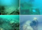
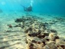
Going even more back in history, we'll found perhaps the most megalitic ruins ever found in the sea, the ruins of Yonagumi, although these ruins are connected to the civilisation of Lemuria, it is great to see that something, anything made by human hand can survive so long.
Hope we'll have better destiny than any of sunken ruins.
Enjoy in photos.
Hope we'll have better destiny than any of sunken ruins.
Enjoy in photos.
Attachments
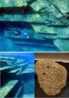

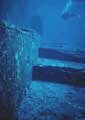
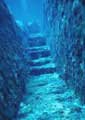
Trending content
-

-

-
Thread 'Coronavirus Pandemic: Apocalypse Now! Or exaggerated scare story?'
- wanderingthomas
Replies: 30K -
