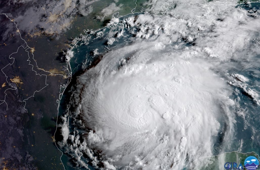
Extreme Hurricane Harvey Video from Aransas County, TX - 8/25/2017
StormChasingVideo
Published on Aug 26, 2017
INSANE video of buildings ripping apart, lightning flashes inside intense eyewall, image of stars and lightning-illuminated "stadium seating effect" eyewall from inside eye, powerlines sparking, high winds, storm surge flooding, damage from Rockport and Fulton, Texas.
Rockport, TX Hurricane Harvey Major Damage B-Roll - 8/26/2017 (2:16)
Published on Aug 26, 2017
https://www.youtube.com/watch?v=3HrGehuBdwo
Damage aftermath in Rockport from Hurricane Harvey showing parts of the town that were heavily damaged during the overnight.
Rockport, TX After Hurricane Harvey Showing What Happened - 8/26/2017 (2:59)
Published on Aug 26, 2017
https://www.youtube.com/watch?v=F14wwhbpSQk
https://www.youtube.com/watch?v=GiuJMxrnifI
Damage, debris, storm surge and flooding aftermath in Rockport TX after Category 4 Hurricane Harvey pounded city and surrounding areas.
Continual Updates: KSAT San Antonio News, Texas News
_https://www.ksat.com/weather#/alerts
Tropical Storm Warning issued August 26 at 12:48PM CDT expiring August 29 at 12:48PM:
Goliad County Victoria County Karnes County BexaHays County Wilson County Comal County Guadalupe County Gonzales County Caldwell County De Witt County Bee County La Salle County Webb County Atascosa County Blanco County Kendall County Lavaca County
Wind Advisory:Bandera County Frio County Medina County
_https://www.ksat.com/weather/alerts/wind-advisory_81890904
Williamson-Bandera-Kendall-Blanco-Travis-Lee-Medina-Frio- Including the cities of Georgetown, Bandera, Boerne, Blanco, Austin, Giddings, Hondo, and Pearsall 1146 AM CDT Sat Aug 26 2017 ...WIND ADVISORY REMAINS IN EFFECT UNTIL 10 PM CDT THIS EVENING...
* TIMING...Through 10 PM.
* WINDS...Sustained winds of 25 to 35 mph with gusts to 40 mph.
* IMPACTS...Driving high profile vehicles will be difficult through the day. Large tree limbs could fall and cause damage. PRECAUTIONARY/PREPAREDNESS ACTIONS... A Wind Advisory means that winds of 26 to 39 mph are expected. Winds this strong can make driving difficult, especially for high profile vehicles. Use extra caution
Flood Warning
_https://www.ksat.com/weather#/alerts
949 AM CDT Sat Aug 26 2017 The Flood Warning continues for the Nueces River Near Three Rivers. * from Monday evening, until further notice, or until the warning is cancelled.
* At 9:15 AM Saturday, the stage was 1.5 feet. * Moderate flooding is forecast.
* Flood stage is 25.0 feet.
* Forecast: Rise above flood stage by Monday evening, and continue to rise to near 33.1 feet by Wednesday early afternoon.
* At 32.0 feet, the Nueces River backs up minor creeks to near the slab elevation of homes in the River Creek Acres Subdivision, five miles southeast of George West. Livestock are cut off and could drown in low areas of the flood plain.
Tropical Storm Warning Live Oak County
Live Oak- 101 PM CDT Sat Aug 26 2017 ...TROPICAL STORM WARNING REMAINS IN EFFECT...
* LOCATIONS AFFECTED - Three Rivers - George West
* WIND - LATEST LOCAL FORECAST: Below tropical storm force wind - Peak Wind Forecast: 25-35 mph with gusts to 45 mph - CURRENT THREAT TO LIFE AND PROPERTY: Elevated - The wind threat has remained nearly steady from the previous assessment. - Remain braced against the reasonable threat for tropical storm force wind of 39 to 57 mph. - To be safe, efforts should fully focus on avoiding injury. Properties remain subject to limited wind impacts. - Now is the time to hide from the wind. Remain sheltered until the hazardous wind subsides. - POTENTIAL IMPACTS: Unfolding - Potential impacts from the main wind event are unfolding.
* FLOODING RAIN - LATEST LOCAL FORECAST: Flash Flood Watch is in effect - Peak Rainfall Amounts: Additional 6-10 inches, with locally higher amounts - CURRENT THREAT TO LIFE AND PROPERTY: High - The flooding rain threat has remained nearly steady from the previous assessment. - Emergency considerations should include a threat of flooding. - Be safe and remain ready to protect against flooding rain impacts. - If flood related watches and warnings are in effect, heed recommended actions. -
POTENTIAL IMPACTS: Extensive - Major rainfall flooding may prompt many evacuations and rescues. - Rivers and tributaries may rapidly overflow their banks in multiple places. Small streams, creeks, canals, and ditches may become dangerous rivers. Flood control systems and barriers may become stressed. - Flood waters can enter many structures within multiple communities, some structures becoming uninhabitable or washed away. Many places where flood waters may cover escape routes. Streets and parking lots become rivers of moving water with underpasses submerged. Driving conditions become dangerous. Many road and bridge closures with some weakened or washed out.
* TORNADO - LATEST LOCAL FORECAST: - Situation is unfavorable for tornadoes - CURRENT THREAT TO LIFE AND PROPERTY: None - The tornado threat has remained nearly steady from the previous assessment. - Emergency considerations need not include a threat for tornadoes. Showers and thunderstorms with strong gusty winds may still occur. - Little to no preparations needed to guard against tropical tornadoes. - Ensure readiness for the next tropical tornado event. -
POTENTIAL IMPACTS: Little to None - Little to no potential impacts from tornadoes.
* FOR MORE INFORMATION: - -http://www.weather.gov/srh/tropical?office=crp $$
08-26-2018 Rockport, Texas - Hurricane Harvey aerial imagery destruction (6:54)
Live Storms Media


