Chad
The Living Force
For some background on the quake swarm in Malaga, there's an article from October 2019 that mentions an M4 and a swarm of 25 quakes.
As for the current situation, there's a Spanish news article that was posted 30 minutes ago (translated with DeepL), that talks about there being 280 'tremors' this time, apparently counting from when it started which seems to be December 2nd but then it 'restarted' late January. There's some dispute as to whether this is a swarm of lots of little quakes or one large one with lots of tremors. One comment in the article claims this is 'usual' for the region... those are some of the main points but there's some interesting little snippets about earthquakes and the potential threat more generally. The original article in Spanish can be found in the 'spoiler' below:
, a 23 de enero de 2021.#{emoji}13; 23 ENERO 2021#{emoji}13; Álex Cámara / Europa Press#{emoji}13; 23/01/2021")
Un equipo de bomberos observa las grietas aparecidas en uno de los edificios afectados por los terremotes en la zona de Granada .
Álex Cámara / EP

Joaquim Elcacho
27/01/2021 11:16Actualizado a 27/01/2021 11:41
281 terremotos en menos de dos meses, 41 de los cuales han sido sentidos por la población y cuyo punto álgido ha sido el movimiento de magnitud 4,4 registrado el 23 de enero. Este es el balance provisional del Instituto Geográfico Nacional en referencia a la actividad sísmica en la zona de Atarfe-Santa Fe, al noroeste de la ciudad de Granada.
El Instituto Geográfico y la Red Sísmica Nacional indican en la nota publicada el 26 de enero que se trata de una "serie" de terremotos superficiales y de " 172 réplicas desde el terremoto principal", pero algunos expertos apuntan que el fenómeno de Atarfe-Santa Fe puede encuadrarse también en lo que se denomina un enjambre sísmico.
Los enjambres de terremotos son un poco diferentes. En un enjambre, no hay un choque principal, ni un gran terremoto que inicie una secuencia. En cambio, los terremotos de n enjambre ocurren a ritmos y magnitudes que no obedecen a ninguna de las condiciones que siguen las secuencias de réplicas.
Una de las diferencias principales entre réplicas y enjambres es que las primeras se producen al poco tiempo de los sucesos principales, mientras que los enjambres pueden mantenerse durante períodos muy largos.

Grietas identificadas en un edificio afectado en Atarfe
IGN
El término enjambre sísmico (del inglés earthquake swarm) tiene como principal antecedente el sustantivo schwarmbeben , (terremoto de enjambre) utilizado en 1899 por el geólogo austríaco Josef Knett para referirse a la agrupación temporal de más de un centenar de movimientos en la zona de los montes Metálicos (Bohemia occidental/Vogtland, entre Alemania y República Checa) entre enero y febrero de 1824.
Con el término "enjambre", el profesor Knett se refería a la impresión de que estos pequeños terremotos se agrupaban de forma similar a las abejas.

Localización de los terremotos cerca de Granada
IGN
Además del mencionado enjambre de terremotos de los montes Metálicos, en Europa se conocen sucesos similares en el valle de Ubaye (Francia), con más de 16.000 movimientos de entre 2003 y 2004; la parte baja del valle del Ródano (Tricastin, Francia), con episodios similares en 1772-1773 y 1933-1936; y el valle de Maurienne (Francia), con un enjambre de terremotos desde diciembre de 1838 hasta junio de 1844.
Más recientemente, entre 2015 y 2017 se conoce el enjambre sísmico de Montgellafrey, también en Francia.
De hecho, los enjambres símicos son más comunes en las regiones volcánicas (por ejemplo Japón, Italia central, la depresión de Afar o Islandia), donde ocurren antes y durante las erupciones.
Este fenómeno también se observa en zonas de vulcanismo cuaternario o de circulación hidrotermal (por ejemplo, Vogtland / Bohemia occidental o el macizo de los Vosgos ).
o también, aunque con menos frecuencia, lejos de los límites de las placas tectónicas (Nevada, Oklahoma o Escocia ).
Con menor frecuencia, los enjambres sísmicos también aparecen en los límites de las placas tectónicas, como sería el caso de Granada.

Terremotos destacados en los últimos meses en la zona Atarfe - Santa Fe
IGN
Los enjambres de terremotos plantean problemas desde el punto de vista de la seguridad pública: primero porque no se puede determinar el final de la actividad sísmica; en segundo lugar, porque nunca se puede estar seguro de que no ocurrirá otro terremoto con una magnitud mayor que los choques anteriores de la secuencia.
El terremoto de L'Aquila de 2009 en Italia es emblemático, con un suceso de magnitud 6,3 después de una actividad de enjambre con magnitudes entre 1 y 3.
Si bien los enjambres suelen generar choques moderados, la persistencia de los terremotos que se sienten durante un tiempo prolongado puede ser disruptiva y causar angustia a la población, recuerdan los expertos.
"La serie se ha reactivado posteriormente a finales de enero de 2021 y el día 23 el IGN ha registrado un terremoto con magnitud Mw de 4,4 al noroeste de Santa Fe con intensidad máxima de V-VI en Atarfe, que ha sido fuertemente sentido en numerosas localidades cercanas al epicentro, así como en la ciudad de Granada, llegando incluso a sentirse en algunas localidades de las provincias de Málaga y Jaén", indica la versión oficial.
La sismicidad registrada "es habitual en esta zona", que se enmarca dentro del sector central de las cordilleras Béticas, una de las regiones con mayor actividad sísmica de la Península Ibérica, fruto de la convergencia entre la placa Africana y Euroasiática, explica el IGN.

Principales zonas sísmicas del sur de la península Ibérica
IGN
"Esta zona se caracteriza por la ocurrencia de numerosos terremotos superficiales de baja a moderada magnitud, y de forma ocasional con intensidad significativa. También existe cierta sismicidad a profundidades intermedias que se extiende en la parte occidental del mar de Alborán y, ocasionalmente, terremotos a profundidades de más de 600 km con epicentro en la provincia de Granada cuyo origen está posiblemente relacionado con la historia tectónica del arco de Gibraltar, sobre la cual no existe un acuerdo unánime.
También destacan los terremotos de 1531 en la cuenca de Baza con intensidad VIII-IX y el de 1804 en la cuenca de Dalías con intensidad VIII-IX, que produjo gran destrucción en Dalias, Berja y Roquetas y 407 víctimas.
As for the current situation, there's a Spanish news article that was posted 30 minutes ago (translated with DeepL), that talks about there being 280 'tremors' this time, apparently counting from when it started which seems to be December 2nd but then it 'restarted' late January. There's some dispute as to whether this is a swarm of lots of little quakes or one large one with lots of tremors. One comment in the article claims this is 'usual' for the region... those are some of the main points but there's some interesting little snippets about earthquakes and the potential threat more generally. The original article in Spanish can be found in the 'spoiler' below:
Grenada's seismic swarm and the history of serial earthquakes
Alert: 280 tremors in a row
Terremoto Granada: El enjambre sísmico de Granada y la historia de los terremotos en serie
281 terremotos en menos de dos meses, 41 de los cuales han sido sentidos por la población y cuyo punto álgido ha sido el movimiento de magnitud 4,4 registrado elwww.lavanguardia.com
Repeated ground shaking causes scenes of concern and even panic in the Granada area of Atarfe - Santa Fe
The most shocking videos and images of the earthquakes that have shaken Granada

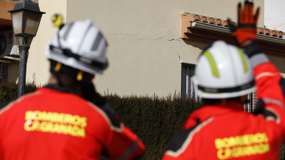
Firefighters operating after the 4.4 magnitude earthquake with epicentre in Santa Fe, which has left numerous material damages in several houses in the town of Atarfe. In Granda (Andalusia, Spain), 23 January 2021.#{emoji}13; 23 JANUARY 2021#{emoji}13; Álex Cámara / Europa Press#{emoji}13; 23/01/2021
A team of firefighters observes the cracks that have appeared in one of the buildings affected by the earthquakes in the Granada area. Álex Cámara / EP
The Granada seismic swarm and the history of serial earthquakes
Joaquim Elcacho
27/01/2021 11:16Actualizado a 27/01/2021 11:41
281 earthquakes in less than two months, 41 of which have been felt by the population and whose high point has been the 4.4 magnitude movement recorded on 23 January. This is the provisional balance of the National Geographic Institute in reference to the seismic activity in the Atarfe-Santa Fe area, northwest of the city of Granada.
The Geographic Institute and the National Seismic Network indicate in the note published on 26 January that this is a "series" of surface earthquakes and "172 aftershocks since the main earthquake", but some experts point out that the Atarfe-Santa Fe phenomenon may also be part of what is known as a seismic swarm.
Differences between aftershocks and swarms
Aftershocks are smaller movements that follow the main earthquakes. They are caused by adjustments or slippage that tend to restore stability to the affected area. Aftershocks are the result of the main earthquakes.
Earthquake swarms are a little different. In a swarm, there is no mainshock, nor is there a large earthquake that initiates a sequence. In contrast, n-swarm earthquakes occur at rates and magnitudes that do not obey any of the conditions that follow aftershock sequences.
One of the main differences between aftershocks and swarms is that aftershocks occur soon after the main events, whereas swarms can be sustained for very long periods of time.
Cracks identified in an affected building in Atarfe

Cracks identified in an affected building in Atarfe IGN
A million earthquakes
Hopefully nothing similar will happen in Granada but the modern history of seismology includes a prominent section for the Matsushiro swarm (a suburb of the Japanese city of Nagano) which generated around 1 million earthquakes between 1965 and 1967.
The term earthquake swarm has as its main antecedent the noun schwarmbeben , (swarm earthquake) used in 1899 by the Austrian geologist Josef Knett to refer to the temporary grouping of more than a hundred movements in the area of the Ore Mountains (West Bohemia/Vogtland, between Germany and the Czech Republic) between January and February 1824.
By the term "swarm", Professor Knett meant the impression that these small earthquakes were clustered together in a bee-like manner.
Location of earthquakes near Granada

Location of the earthquakes near Granada IGN
In addition to the aforementioned earthquake swarm in the Monts-Métalliques, similar events are known in Europe in the Ubaye valley (France), with more than 16,000 movements between 2003 and 2004; the lower Rhône valley (Tricastin, France), with similar episodes in 1772-1773 and 1933-1936; and the Maurienne valley (France), with a swarm of earthquakes from December 1838 to June 1844.
More recently, between 2015 and 2017, the Montgellafrey seismic swarm is known, also in France.
A similar case on La Palma
In Spain, the most recent grouping of ground motions recognised as a seismic swarm occurred on the island of La Palma (Canary Islands) in the last week of 2020. Between 22 and 26 December, more than 600 movements were recorded in the south of this Canary Island. The National Geographic Institute stressed at the time that "the occurrence of events of this type in an active volcanic area is within normality and presents no risk to the population".
In fact, simian swarms are more common in volcanic regions (e.g. Japan, central Italy, the Afar depression or Iceland), where they occur before and during eruptions.
This phenomenon is also observed in areas of Quaternary volcanism or hydrothermal circulation (e.g. Vogtland / West Bohemia or the Vosges massif).
or also, although less frequently, far from tectonic plate boundaries (Nevada, Oklahoma or Scotland).
Less frequently, seismic swarms also occur at tectonic plate boundaries, as would be the case in Granada.

Outstanding earthquakes in the last months in the area Atarfe - Santa Fe
Outstanding earthquakes in recent months in the Atarfe - Santa Fe area IGN
Earthquake swarms pose problems from a public safety point of view: firstly, because the end of the seismic activity cannot be determined; secondly, because one can never be sure that another earthquake with a magnitude greater than the previous shocks in the sequence will not occur.
The 2009 L'Aquila earthquake in Italy is emblematic, with a magnitude 6.3 event following swarm activity with magnitudes between 1 and 3.
While swarms usually generate moderate shocks, the persistence of earthquakes that are felt for a prolonged time can be disruptive and cause distress to the population, experts recall.
More data on the case of Granada
The National Geographic Institute (IGN) details in its official report that "on 2 December the National Seismic Network recorded an earthquake of magnitude 3.6 and maximum intensity of IV-V in Atarfe and Santa Fe, which was widely felt in numerous localities near the epicentre but without causing any damage".
"The series has subsequently been reactivated at the end of January 2021 and on the 23rd the IGN has recorded an earthquake with magnitude Mw of 4.4 northwest of Santa Fe with maximum intensity of V-VI in Atarfe, which has been strongly felt in numerous localities near the epicentre, as well as in the city of Granada, even being felt in some localities in the provinces of Malaga and Jaen," the official version indicates.
The seismicity recorded "is usual in this area", which is part of the central sector of the Betic mountain ranges, one of the most seismically active regions of the Iberian Peninsula, as a result of the convergence between the African and Eurasian plates, explains the IGN.
Main seismic zones in the south of the Iberian Peninsula

Main seismic zones in the south of the Iberian Peninsula IGN
"This zone is characterised by the occurrence of numerous shallow earthquakes of low to moderate magnitude, and occasionally with significant intensity. There is also some seismicity at intermediate depths extending into the western part of the Alboran Sea and, occasionally, earthquakes at depths of more than 600 km with epicentres in the province of Granada whose origin is possibly related to the tectonic history of the Gibraltar arc, on which there is no unanimous agreement.
A very eventful history
Important earthquakes have occurred in the province of Granada throughout history, with the Granada basin being the most seismically active, according to the IGN. The oldest recorded earthquake occurred in 1431 to the south of Granada, with a macroseismic intensity of VIII-IX, causing great damage to the Alhambra, and the most virulent in 1884 in Arenas del Rey, which reached an intensity of IX-X and killed 839 people.
Also noteworthy are the earthquakes of 1531 in the Baza basin with an intensity of VIII-IX and that of 1804 in the Dalías basin with an intensity of VIII-IX, which caused great destruction in Dalias, Berja and Roquetas and 407 victims.
El enjambre sísmico de Granada y la historia de los terremotos en serie
Alerta: 280 temblores seguidos
La repetición de movimientos de tierra provoca escenas de preocupación e incluso pánico en la zona granadina de Atarfe - Santa Fe
Los vídeos e imágenes más impactantes de los terremotos que han sacudido Granada
¿Cubre el seguro los daños por terremoto?
Un equipo de bomberos observa las grietas aparecidas en uno de los edificios afectados por los terremotes en la zona de Granada .
Álex Cámara / EP
Joaquim Elcacho
27/01/2021 11:16Actualizado a 27/01/2021 11:41
281 terremotos en menos de dos meses, 41 de los cuales han sido sentidos por la población y cuyo punto álgido ha sido el movimiento de magnitud 4,4 registrado el 23 de enero. Este es el balance provisional del Instituto Geográfico Nacional en referencia a la actividad sísmica en la zona de Atarfe-Santa Fe, al noroeste de la ciudad de Granada.
El Instituto Geográfico y la Red Sísmica Nacional indican en la nota publicada el 26 de enero que se trata de una "serie" de terremotos superficiales y de " 172 réplicas desde el terremoto principal", pero algunos expertos apuntan que el fenómeno de Atarfe-Santa Fe puede encuadrarse también en lo que se denomina un enjambre sísmico.
Diferencias entre réplica y enjambre
Las réplicas son movimientos de menor magnitud que siguen a los terremotos principales. Están causadas por ajustes o deslizamientos que tienden a recuperar la estabilidad de la zona afectada. Las réplicas son el resultado de los terremotos principales.Los enjambres de terremotos son un poco diferentes. En un enjambre, no hay un choque principal, ni un gran terremoto que inicie una secuencia. En cambio, los terremotos de n enjambre ocurren a ritmos y magnitudes que no obedecen a ninguna de las condiciones que siguen las secuencias de réplicas.
Una de las diferencias principales entre réplicas y enjambres es que las primeras se producen al poco tiempo de los sucesos principales, mientras que los enjambres pueden mantenerse durante períodos muy largos.
Grietas identificadas en un edificio afectado en Atarfe
IGN
Un millón de terremotos
Esperemos que en Granada no ocurra nada parecido pero la historia moderna de la sismología incluye un apartado destacado para el enjambre de Matsushiro (un suburbio de la ciudad japonesa de Nagano) que entre los años 1965 y 1967 generó alrededor de 1 millón de terremotos.El término enjambre sísmico (del inglés earthquake swarm) tiene como principal antecedente el sustantivo schwarmbeben , (terremoto de enjambre) utilizado en 1899 por el geólogo austríaco Josef Knett para referirse a la agrupación temporal de más de un centenar de movimientos en la zona de los montes Metálicos (Bohemia occidental/Vogtland, entre Alemania y República Checa) entre enero y febrero de 1824.
Con el término "enjambre", el profesor Knett se refería a la impresión de que estos pequeños terremotos se agrupaban de forma similar a las abejas.
Localización de los terremotos cerca de Granada
IGN
Además del mencionado enjambre de terremotos de los montes Metálicos, en Europa se conocen sucesos similares en el valle de Ubaye (Francia), con más de 16.000 movimientos de entre 2003 y 2004; la parte baja del valle del Ródano (Tricastin, Francia), con episodios similares en 1772-1773 y 1933-1936; y el valle de Maurienne (Francia), con un enjambre de terremotos desde diciembre de 1838 hasta junio de 1844.
Más recientemente, entre 2015 y 2017 se conoce el enjambre sísmico de Montgellafrey, también en Francia.
Un caso similar en La Palma
En España, la más reciente agrupación de movimientos de tierra reconocida como un enjambre sísmico se produjo en la isla de La Palma (Canarias) la última semana de 2020. Entre los días 22 y 26 de diciembre se registraron en el sur de esta isla canaria más de 600 movimientos. El Instituto Geográfico Nacional destacó entonces que "la ocurrencia de eventos de este tipo en una zona volcánica activa se encuentra dentro de la normalidad y no presenta riesgo alguno para la población".De hecho, los enjambres símicos son más comunes en las regiones volcánicas (por ejemplo Japón, Italia central, la depresión de Afar o Islandia), donde ocurren antes y durante las erupciones.
Este fenómeno también se observa en zonas de vulcanismo cuaternario o de circulación hidrotermal (por ejemplo, Vogtland / Bohemia occidental o el macizo de los Vosgos ).
o también, aunque con menos frecuencia, lejos de los límites de las placas tectónicas (Nevada, Oklahoma o Escocia ).
Con menor frecuencia, los enjambres sísmicos también aparecen en los límites de las placas tectónicas, como sería el caso de Granada.
Terremotos destacados en los últimos meses en la zona Atarfe - Santa Fe
IGN
Los enjambres de terremotos plantean problemas desde el punto de vista de la seguridad pública: primero porque no se puede determinar el final de la actividad sísmica; en segundo lugar, porque nunca se puede estar seguro de que no ocurrirá otro terremoto con una magnitud mayor que los choques anteriores de la secuencia.
El terremoto de L'Aquila de 2009 en Italia es emblemático, con un suceso de magnitud 6,3 después de una actividad de enjambre con magnitudes entre 1 y 3.
Si bien los enjambres suelen generar choques moderados, la persistencia de los terremotos que se sienten durante un tiempo prolongado puede ser disruptiva y causar angustia a la población, recuerdan los expertos.
Más datos sobre el caso de Granada
El Instituto Geográfico Nacional (IGN) detalla en su informe oficial que "el día 2 de diciembre la Red Sísmica Nacional registró un terremoto de magnitud 3,6 e intensidad máxima de IV-V en Atarfe y Santa Fe, que fue ampliamente sentido en numerosas localidades cercanas al epicentro pero sin causar ningún daño"."La serie se ha reactivado posteriormente a finales de enero de 2021 y el día 23 el IGN ha registrado un terremoto con magnitud Mw de 4,4 al noroeste de Santa Fe con intensidad máxima de V-VI en Atarfe, que ha sido fuertemente sentido en numerosas localidades cercanas al epicentro, así como en la ciudad de Granada, llegando incluso a sentirse en algunas localidades de las provincias de Málaga y Jaén", indica la versión oficial.
La sismicidad registrada "es habitual en esta zona", que se enmarca dentro del sector central de las cordilleras Béticas, una de las regiones con mayor actividad sísmica de la Península Ibérica, fruto de la convergencia entre la placa Africana y Euroasiática, explica el IGN.
Principales zonas sísmicas del sur de la península Ibérica
IGN
"Esta zona se caracteriza por la ocurrencia de numerosos terremotos superficiales de baja a moderada magnitud, y de forma ocasional con intensidad significativa. También existe cierta sismicidad a profundidades intermedias que se extiende en la parte occidental del mar de Alborán y, ocasionalmente, terremotos a profundidades de más de 600 km con epicentro en la provincia de Granada cuyo origen está posiblemente relacionado con la historia tectónica del arco de Gibraltar, sobre la cual no existe un acuerdo unánime.
Una historia muy movida
En la provincia de Granada han ocurrido importantes erremotos a lo largo de la historia, siendo la cuenca de Granada la más activa sísmicamente, recuerda el IGN. El más antiguo del que se tiene constancia ocurrió en 1431 al sur de Granada que tuvo una intensidad macrosísmica de VIII-IX produciendo grandes daños en la Alhambra y el más virulento el de 1884 en Arenas del Rey, que alcanzó una intensidad de IX-X produciendo 839 víctimas mortales.También destacan los terremotos de 1531 en la cuenca de Baza con intensidad VIII-IX y el de 1804 en la cuenca de Dalías con intensidad VIII-IX, que produjo gran destrucción en Dalias, Berja y Roquetas y 407 víctimas.