Earthquakes around the world

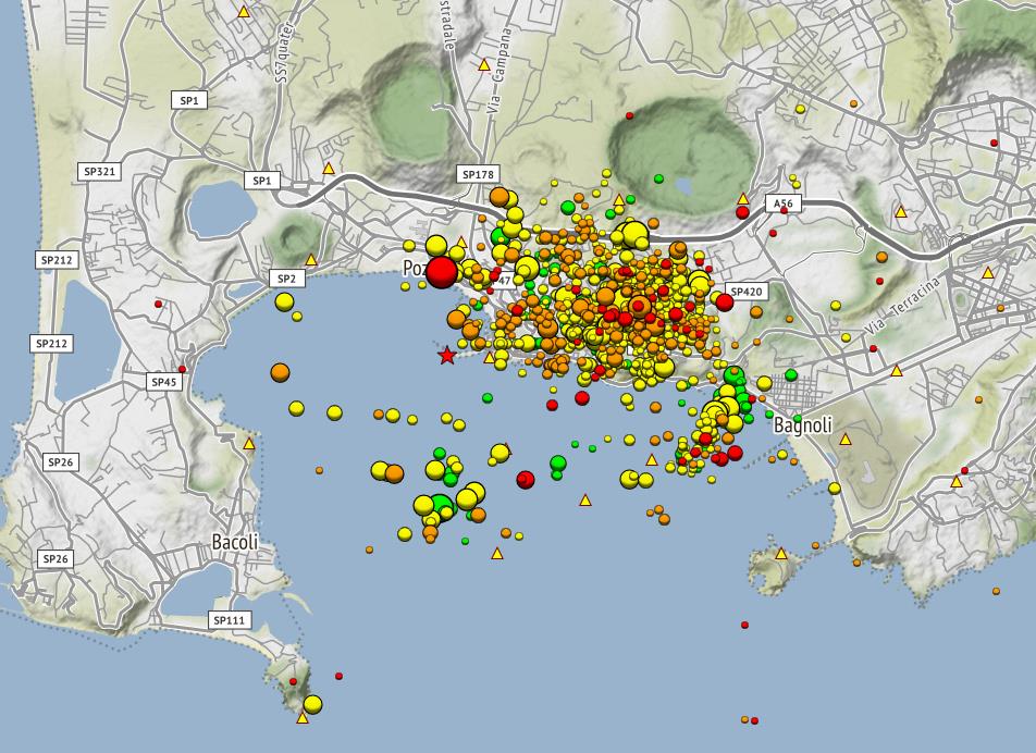
Strong earthquake in South Pacific Ocean on Monday, Jun 5, 2023 at 12:45 pm local time

M 5.8 - Balleny Islands region
2023-06-05 02:45:58 (UTC)
62.325°S 155.427°E. 10.0 km depth
USGS earthquake alert
chrome_screenshot_1685934908993.png

Atmospheric Fluctuation detected on June 01
2023-06-01a.jpg

The M5.8 earthquake occurs after the full moon on June 4.
2023-05-30.png
The last critical planetary alignment according to SSGEOS will occur in a few hours on June 5 involving Earth, Mercury and Uranus.

Uranus appears to be a key indicator with the occurrence of great earthquakes. In the last 600 years the greatest earthquakes occurred when Uranus was conjunct or opposite the constellations Aries (25%), Leo (55%) and Sagittarius (20%).

Let's wait and see.
 
WORLDWIDE EARTHQUAKE REPORT JUNE 05_2023

M 5.2 - west of Macquarie Island
M 5.8 - Balleny Islands region

● M 5.2 - 151 km SSW of Kokopo, Papua New Guinea
2023-06-05 15:41:40 (UTC)
5.688°S 151.993°E. 10.0 km depth
USGS earthquake alert

● M 5.0 - 18 km NW of Lluta, Peru
2023-06-05 11:55:30 (UTC)
15.910°S 72.145°W. 10.0 km depth
USGS earthquake alert
chrome_screenshot_1686009414914.png

● oM 4.6 - 8 km SE of Göksun, Turkey
2023-06-05 16:40:47 (UTC)
37.977°N 36.576°E. 10.5 km depth
USGS earthquake alert

● Summary

Seismic activity level has been at moderate levels in the last 24 hours. This is the last chart posted by Volcanodiscovery at 23:00 UTC on Jun 05 Global seismic activity chart
  • 4 quakes above magnitude 5
  • 27 quakes between magnitude 4 and 5
  • 99 quakes between magnitude 3 and 4
  • 219 quakes between magnitude 2 and 3
  • 467 quakes below magnitude 2 that people normally don't feel.
~816 earthquakes in the past 24h (883 earthquakes in the 24 hours prior to this report) Estimated combined seismic energy release: 6277 tons of TNT or 0.4 atomic bombs!
Volcanodiscovery earthquake report 24h
 
WORLDWIDE EARTHQUAKE REPORT JUNE 06_2023

● M 5.2 - 280 km E of Vao, New Caledonia
2023-06-06 21:48:03 (UTC)
23.048°S 170.200°E. 10.0 km depth
USGS earthquake alert

● M 5.2 - southeast of the Loyalty Islands
2023-06-06 23:38:13 (UTC)
23.116°S 170.384°E. 33.1 km depth
USGS earthquake alert

chrome_screenshot_1686097586048.png

● M 4.9 - 9 km NE of Les Abricots, Haiti
2023-06-06 09:11:23 (UTC)
18.702°N 74.235°W. 10.0 km depth
USGS earthquake alert

M 4.7 - 4 km SSE of Fântânele, Romania
2023-06-06 17:26:51 (UTC)
46.083°N 21.396°E. 5.7 km depth
USGS earthquake alert

M 4.5 - Tarapaca-Antofagasta border region, Chile
2023-06-06 17:41:52 (UTC)
21.309°S 69.925°W. 51.2 km depth
USGS earthquake alert

M 4.5 - 17 km SSE of Uñon, Peru
2023-06-06 17:53:21 (UTC)
15.883°S 72.378°W. 10.0 km depth
USGS earthquake alert
chrome_screenshot_1686098867549.png

● Summary

Seismic activity level has been at low levels in the last 24 hours. This is the last chart posted by Volcanodiscovery at 23:00 UTC on Jun 06 Global seismic activity chart
  • 2 quakes above magnitude 5
  • 28 quakes between magnitude 4 and 5
  • 81 quakes between magnitude 3 and 4
  • 240 quakes between magnitude 2 and 3
  • 525 quakes below magnitude 2 that people normally don't feel.
~876 earthquakes in the past 24h (816 earthquakes in the 24 hours prior to this report) Estimated combined seismic energy release: 4648 tons of TNT or 0.3 atomic bombs
Volcanodiscovery earthquake report 24h
 
WORLDWIDE EARTHQUAKE REPORT JUNE 07_2023

Agency BMKG recorded an earthquake M6.0 in Indian Ocean, 154 km south of Yogyakarta, Indonesia, on Thursday, Jun 8, 2023 at 12:04 am (GMT) later it was updated to M5.6 by other Seismological Centers

M 5.6 - 139 km S of Wonosari, Indonesia
2023-06-07 17:04:55 (UTC)
9.220°S 110.693°E. 30.9 km depth
USGS earthquake alert

After the M5.1 earthquake in Colombia, other smaller earthquakes were recorded in Peru and Argentina.

M 5.1 - 53 km WSW of Bahía Solano, Colombia
2023-06-07 17:39:24 (UTC)
6.030°N 77.846°W. 10.0 km depth
USGS earthquake alert

M 4.5 - 17 km S of Londres, Argentina
2023-06-07 22:49:43 (UTC)
27.873°S 67.126°W. 190.6 km depth
USGS earthquake alert

M 4.9 - 64 km WSW of Atico, Peru
2023-06-07 22:52:05 (UTC)
16.392°S 74.195°W. 35.0 km depth
USGS earthquake alert

M 4.6 - 66 km S of Atiquipa, Peru
2023-06-07 23:08:19 (UTC)
16.398°S 74.303°W. 21.8 km depth
USGS earthquake alert
chrome_screenshot_1686181692630.png

After Romania was shaken by an M4.7 earthquake, today it was Bulgaria's turn with an M4.6 earthquake.

M 4.6 - Bulgaria
2023-06-07 12:26:38 (UTC)
42.051°N 24.838°E. 10.0 km depth
USGS earthquake alert


● Summary

Seismic activity level has been at moderate levels in the last 24 hours. This is the last chart posted by Volcanodiscovery at 23:00 UTC on Jun 07 Global seismic activity chart
  • 4 quakes between magnitude 5 and 6
  • 28 quakes between magnitude 4 and 5
  • 110 quakes between magnitude 3 and 4
  • 268 quakes between magnitude 2 and 3
  • 649 quakes below magnitude 2 that people normally don't feel.
~1059 earthquakes in the past 24h (876 earthquakes in the 24 hours prior to this report) Estimated combined seismic energy release: 20331 tons of TNT or 1.3 atomic bombs.
Volcanodiscovery earthquake report 24h
 
WORLDWIDE EARTHQUAKE REPORT JUNE 08_2023

● M 5.7 - 262 km ESE of Tadine, New Caledonia
2023-06-08 09:19:28 (UTC)
22.354°S 170.269°E. 17.7 km depth
USGS earthquake alert

● M 5.7 - Rat Islands, Aleutian Islands, Alaska
2023-06-08 20:31:45 (UTC)
52.164°N 177.760°E. 7.1 km depth
USGS earthquake alert

● M 5.2 - 149 km SSW of Kokopo, Papua New Guinea
2023-06-08 07:32:51 (UTC)
5.656°S 151.958°E. 10.0 km depth
USGS earthquake alert

● M 5.1 - southern Mid-Atlantic Ridge
2023-06-08 04:02:35 (UTC)
55.778°S 2.191°W. 10.0 km depth
USGS earthquake alert

● M 5.0 -South Pacific Ocean
2023-06-08 19:13:00 (UTC)
30.5°S 178.73°E. 323 km depth
EMSC earthquake alert

Romania, Bulgaria and Greece have been shaken in recent days with M4+ earthquakes.
After Romania was shaken by an M4.7 earthquake, today it was Bulgaria's turn with an M4.6 earthquake.
● M 4.8 - 6 km SW of Atalánti, Greece
2023-06-08 12:33:53 (UTC)
38.611°N 22.952°E. 10.0 km depth
USGS earthquake alert

● Earthquake Forecast

Major seismic activity for the first days of June has not occurred so far. The only M6+ earthquake occurred on May 31 in New Zealand that preceded the conjunction Venus Mercury Neptune
2023-05-30.png
M 6.2 - Auckland Islands, New Zealand region
2023-05-31 02:21:21 (UTC)
Apparently no fault section reached the inflection point that was anticipated following the critical planetary geometry.

This is interesting because if we look at the averages every 2.7 days an M6+ earthquake occurs after planetary conjunctions and 8 days ago it has not occurred.

Conjunctions are coming up next week
● Mercury Sun Mars on June 09th.
On the 13th a convergence of two planetary conjunctions
● Sun Mercury Neptune early
● Followed by Venus Mercury Jupiter later that day.
2023-06-08-overview.png

We could see strong to significant seismic activity after this convergence. Most likely around June 14 or 15.

As for the Atmospheric Fluctuations we had several fluctuations that marked the Eastern Pacific regions repeatedly since day 4 but so far no major seismic activity in the Americas.
2023-06-04a.jpg
2023-06-05a.jpg
2023-06-06b.jpg
2023-06-07a.jpg

MAGNITUDE PROBABILITY

updated 8 June 2023, 06:06 UTC
6.0-6.46.5-6.97.0-7.47.5-8.48.5+
50%50%50%50%40%

● Summary

Seismic activity level has been at moderate levels in the last 24 hours. This is the last chart posted by Volcanodiscovery at 23:00 UTC on Jun 08 Global seismic activity chart
  • 5 quakes above magnitude 5
  • 38 quakes between magnitude 4 and 5
  • 96 quakes between magnitude 3 and 4
  • 252 quakes between magnitude 2 and 3
  • 513 quakes below magnitude 2 that people normally don't feel.
~904 earthquakes in the past 24h (1059 earthquakes in the 24 hours prior to this report) Estimated combined seismic energy release: 16578 tons of TNT or 1 atomic bombs
Volcanodiscovery earthquake report 24h
 
WORLDWIDE EARTHQUAKE REPORT JUNE 09_2023

EMSC recorded the earthquake in the Macquarie Islands region as M6.0, other seismological agencies such as USGS gave a final magnitude of 5.9.

● M 5.9 - Macquarie Island region
2023-06-09 21:21:42 (UTC)
60.511°S 160.328°E. 9.8 km depth
USGS earthquake alert
chrome_screenshot_1686352242858.png

This M5.9 earthquake occurred in the region that registered an Atmospheric Fluctuation on June 1st.
2023-06-01a.jpg

Another Atmospheric Fluctuation occurred on June 06th, pointing to New Zealand and the region between Fiji and New Caledonia.
2023-06-06b.jpg

● M 5.5 - southern Mid-Atlantic Ridge
2023-06-09 20:43:28 (UTC)
47.323°S 12.704°W. 10.0 km depth
USGS earthquake alert

● M 5.3 - central Mid-Atlantic Ridge
2023-06-09 11:33:35 (UTC)
7.196°N 33.999°W. 10.0 km depth
USGS earthquake alert
chrome_screenshot_1686353972226.png

So far the Venus, Mercury, Saturn alignment brought with it two M5.7 earthquakes while Mercury, Sun, Mars has so far resulted in one M5.9 earthquake.

2023-06-08-overview.png

● Summary

Seismic activity level has been at moderate levels in the last 24 hours. This is the last chart posted by Volcanodiscovery at 23:00 UTC on Jun 08 Global seismic activity chart
  • 3 quakes above magnitude 5
  • 44 quakes between magnitude 4 and 5
  • 110 quakes between magnitude 3 and 4
  • 255 quakes between magnitude 2 and 3
  • 472 quakes below magnitude 2 that people normally don't feel.
~884 earthquakes in the past 24h (904 earthquakes in the 24 hours prior to this report) Estimated combined seismic energy release: 18947 tons of TNT or 1.2 atomic bombs.
Volcanodiscovery earthquake report 24h
 
WORLDWIDE EARTHQUAKE REPORT JUNE 10_2023

● M 5.8 - Fiji region
2023-06-10 09:12:50 (UTC)
15.977°S 179.156°W. 10.0 km depth
USGS earthquake alert
20230610_181325.jpg

Another Atmospheric Fluctuation occurred on June 06th, pointing to New Zealand and the region between Fiji and New Caledonia.
2023-06-06b.jpg

So far Venus, Mercury, Saturn conjunction brought with it a M5.8 earthquake. Next conjunction before June 13 convergence: Mercury, Earth, Saturn.
2023-06-08-overview.png

Two moderate earthquakes hit Greece

● M 4.3 - Crete, Greece
2023-06-10 02:55:02 (UTC)
34.482°N 25.362°E. 38.6 km depth
USGS earthquake alert

● M 4.2 - Greece
2023-06-10 10:04:52 (UTC)
38.587°N 22.896°E. 17.6 km depth
USGS earthquake alert
chrome_screenshot_1686443169273.png

Moderate earthquakes hit South America

● M 4.8 - 38 km WSW of Ovalle, Chile
2023-06-10 13:21:06 (UTC)
30.727°S 71.578°W 40.6 km depth
USGS earthquake alert

● M 4.6 - 82 km NNE of María Elena, Chile
2023-06-10 15:06:46 (UTC)
21.618°S 69.506°W. 10.0 km depth
USGS earthquake alert

● M 4.3 - Salta, Argentina
2023-06-10 07:24:29 (UTC)
24.154°S 66.982°W. 194.5 km depth
USGS earthquake alert
chrome_screenshot_1686444454428.png


● Summary

Seismic activity level has been at moderate levels in the last 24 hours. This is the last chart posted by Volcanodiscovery at 23:00 UTC on Jun 10 Global seismic activity chart
  • 1 quake above magnitude 5
  • 29 quakes between magnitude 4 and 5
  • 101 quakes between magnitude 3 and 4
  • 210 quakes between magnitude 2 and 3
  • 470 quakes below magnitude 2 that people normally don't feel.
~811 earthquakes in the past 24h (884 earthquakes in the 24 hours prior to this report) Estimated combined seismic energy release: 10229 tons of TNT or 0.6 atomic bombs
Volcanodiscovery earthquake report 24h
 
Last week saw 1 M6, which was a M6.3 in the Auckland Islands, NZ.
In the usual area, there were 5 out of 110 earthquakes worldwide equal to or greater than 4.5 and 1999 out of 2407 quakes of all sizes.
Percentage: 83.0%
Last week saw no earthquakes reaching M6.
In the usual area, there was 1 out of 92 earthquakes worldwide equal to or greater than 4.5 and 1912 out of 2276 quakes of all sizes.
Percentage: 84.0%

Earthquakes 7 days to June 11th 2023.gif
 
Strong earthquake in Japan

M 6.2 - Hokkaido, Japan region
2023-06-11 09:54:45 (UTC)
42.532°N 141.917°E
123.3 km depth
USGS earthquake alert
Estimated energy release: 30089 tons of TNT or 1.9 atomic bombs

Data for the same earthquake reported by different agencies

Mag.DepthLocationSource
6.2123 km18 Km WSW of Biratori, JapanUSGS
6.2123 kmHokkaido, Japan RegionRaspberry
Shake
6.2112 kmHOKKAIDO, JAPAN REGIONEMSC
5.9111 kmJapan: Near SapporoRENASS
6.1118 kmJapan [Land]INGV
6.1114 kmHokkaido, Japan RegionGFZ
6.2130 kmJapan: 日本北海道CEIC
6.2114 kmHokkaido, Japan RegionGeoAu
6.210 kmHokkaido, Japan RegionIRIS
Volcanodiscovery
 
WORLDWIDE EARTHQUAKE REPORT JUNE 11_2023

M 6.2 - Hokkaido, Japan region
2023-06-11 09:54:45 (UTC)

Second strong earthquake in the Macquarie Islands region.
● M 5.8 - west of Macquarie Island
2023-06-11 13:08:47 (UTC)
56.929°S 147.613°E. 10.0 km depth
USGS earthquake alert
chrome_screenshot_1686352242858.png

● M 5.2 - 94 km SE of Kimbe, Papua New Guinea
2023-06-11 11:34:53 (UTC)
6.201°S 150.688°E. 10.0 km depth
USGS earthquake alert

● M 5.2 - Kuril Islands
2023-06-11 02:58:01 (UTC)
46.201°N 153.128°E. 10.0 km depth
USGS earthquake alert

South Africa had not experienced an M5+ earthquake for 8 years, this one occurred 50 km north of Beaufort West, with a magnitude 5.3 on June 24, 2015.

● M 5.0 - South Africa
2023-06-11 00:38:52 (UTC)
26.328°S 28.139°E. 10.0 km depth
USGS earthquake alert
chrome_screenshot_1686506809309.png
A security camera captured the moment of the earthquake that just shook southeast Johannesburg, South Africa

● M 5.0 - 14 km E of Central, Alaska
2023-06-11 14:32:20 (UTC)
65.572°N 144.480°W. 13.5 km depth
USGS earthquake alert

● M 5.0 - 134 km ENE of Nabire, Indonesia
2023-06-11 06:51:48 (UTC)
2.979°S 136.648°E. 50.0 km depth
USGS earthquake alert

Now it was the turn of Southwest Turkey after moderate earthquakes have been recorded in the region: Romania, Bulgaria, Greece and Turkey.

● M 4.1 - 8 km SW of Kuşadası, Turkey
2023-06-11 04:42:02 (UTC)
37.799°N 27.192°E. 10.0 km depth
USGS earthquake alert


chrome_screenshot_1686507072899.png

So far the Mercury-Earth Saturn conjunction has brought two strong earthquakes and seismic activity rose to 846 earthquakes in the past 24 h

● Summary

Seismic activity level has been at moderate levels in the last 24 hours. This is the last chart posted by Volcanodiscovery at 23:00 UTC on Jun 11 Global seismic activity chart
  • 1 quake above magnitude 6
  • 6 quakes between magnitude 5 and 6
  • 47 quakes between magnitude 4 and 5
  • 109 quakes between magnitude 3 and 4
  • 221 quakes between magnitude 2 and 3
  • 462 quakes below magnitude 2 that people normally don't feel.
~846 earthquakes in the past 24h (811 earthquakes in the 24 hours prior to this report) Estimated combined seismic energy release: 46434 tons of TNT or 2.9 atomic bombs
Volcanodiscovery earthquake report 24h
 

Attachments

  • 2023-06-08-overview.png
    2023-06-08-overview.png
    94.5 KB · Views: 2
Switzerland | Austria | Italy | Germany • Large landslide
12 June 2023

German Vulkane.net wrote an article about a large landslide on/at a mountain. Since the writer is an avid climate change guy, it is all about climate change being the primary reason behind the landslide. The videos posted at Twitter do give a glimpse of that this must have been a huge landslide, as if "half of the mountain side was coming down"

PS: i had a little bit difficulties to nail down the exact location, in which country the event was located, because their territory seem to be all located in the area. Instead, i listed them all ;-)


Bild_2023-06-12_153810505.jpg

Violent landslide on the southern Fluchthorn triggers earthquake and 'catastrophic atmosphere'

A violent landslide occurred yesterday on the Southern Fluchthorn near Galtür in Tyrol, causing the mountain to lose part of its summit. The event manifested itself around 3:30 p.m. and was captured on video. In the landslide, part of the upper northwest flank of the Southern Fluchthorn sheared off; even the summit cross was swept away and tumbled to the valley. The landslide caused a 2 km long debris avalanche and a torrent that flowed towards the valley.

Although it was a huge event, there was no damage to infrastructure, nor do any people seem to have been affected. Therefore, it is a natural phenomenon rather than a natural disaster. Landslides have existed since the beginning of mountain building and are normal geological processes.

Nevertheless, it is assumed that the landslide is related to anthropogenic climate change, because the peaks of the affected mountain massif are almost 4000 m high and are thus located in the permafrost zone of the Alps, which is above 3000 m. The ground here is normally completely frozen. Normally, the ground here is frozen all year round. This is also true for the water in rock crevasses. Due to global warming, the altitude of the permafrost region is shifting and the thawing of soils and rock crevasses can destabilize mountain slopes and lead to landslides.


Shocks from landslide registered as earthquake

Bild_2023-06-12_151549108.jpg

Of course, other events can also trigger landslides. These include earthquakes. This once prompted me to check with the EMSC whether there was an earthquake in the Alps. Indeed there was, because at the same time as the landslide an earthquake of magnitude 2.2 was registered at the Fluchthorn. It has a negative depth indication and manifested itself at a height of 2 km, that is, in the mountain massif. I suspect that it was not the earthquake that triggered the landslide, but that the tremors originating from the landslide were registered as earthquakes.

On the shakemap you can also see that there was a weak earthquake south of the Fluchthorn before, but whether this shaking triggered the landslide is unlikely.
 
Campi Flegrei - Pozzuoli, Napoli, Italy
11 June 2023
A mild earthquake occurred in Pozzuoli, the town that lies near the center of the Campi Flegrei submerged caldera, and marks with this a stronger earthquake compared to e previous peaks (recently there was a M 3.0 if i recall correctly). Supposedly, the M 3.6 earthquake was the strongest earthquake in the area in the past 40 years. The gradual increase of unsettledness in the past year in that area, does give me some worry...

German Vulkane.net wrote an article about it:


Earthquake ML 3.6 shakes Italian caldera volcano Campi Flegrei

Date 11.06.23 | Time: 06:44:25 UTC | 40,831; 14,111 | Depth: 11 km | ML 3.6


cf.jpg

This morning a magnitude 3.6 earthquake struck the Italian caldera volcano Campi Flegrei. The hypocenter was located at 2600 m depth. The epicenter was located on the coast east of Monte Nuovo and west of Solfatara crater. The earth tremor occurred at 06:44:25 UTC (08:44:25 local time) and could be clearly felt by local residents. The EMSC has received corresponding reports. According to these reports, the earthquake was felt for 4 to 5 seconds. Together with another earthquake M 3.6, which had occurred in March last year, the earthquake is one of the strongest of the current uplift phase.

Earthquake activity has been quite high in the Campi Flegrei area for several weeks. There is practically a continuous swarm earthquake in progress, with several weak tremors occurring daily. The INGV monthly report for May states that 661 tremors were recorded. A value close to the peak in April, when 685 tremors occurred. The values this year lead the top of the histograms of the current uplift phase and show that seismicity has increased significantly. Nevertheless, twice as many earthquakes were recorded at peak times during the 1980s uplift phase.

Ground uplift remained high in May at 15 mm per month. This value was measured at the RITE monitoring station. Looking more closely at the readings, we see a slight subsidence for the last few weeks in May. It looks as if the ground elevation occurs in phases during which it increases strongly and then stagnates or decreases slightly for a few weeks. In the weekly report for the first week of June, one can see that currently there is again an uplift phase. The uplift is still given by INGV as 15 mm/month.

The gas temperatures of the main fumarole of Pisciarelli continue to average 96 degrees.

Volcanologists conclude that the general trend described for months is continuing and do not see any worrying changes in the behavior of the caldera volcano. For residents of the region, of course, the development is worrying, even more so when there are noticeable earthquakes, as was the case today. Then people become aware that they are living on a powder keg. According to a new study, the risk of eruption is greater than many specialists had assumed.


END OF ARTICLE
Published only recently an article/study in Nature, 9 June 2023


Potential for rupture before eruption at Campi Flegrei caldera, Southern Italy​

Abstract

Volcanoes reawakening after long repose must rupture the crust before magma can erupt. Rupture is preceded by repeatable variations in the rate of seismicity with ground movement, which trace the amount of applied stress that is released by local earthquakes. A rupturing sequence has been developing across four episodes of ground uplift at Italy’s Campi Flegrei caldera: in 1950-1952, 1969-1972, 1982-1984 and since 2004. We predicted in 2016 that the approach to rupture would continue after an additional uplift of 30-40 cm at the location of largest movement. We have updated our analysis with new data on changes in the numbers of local earthquakes with amounts of ground movement. Here we show that subsequent events have confirmed our prediction and that the unrest has been changing the structure of Campi Flegrei’s crust. The results provide new constraints for evaluating the volcano’s potential to erupt or to subside without eruption.
 
WORLDWIDE EARTHQUAKE REPORT JUNE 12_2023

Seismic activity has been at low levels in the last 24 hours which coincides with the pause prior to the critical planetary convergence on June 13 according to SSGEOS analysis.

● M 5.0 - Volcano Islands, Japan region
2023-06-12 01:23:43 (UTC)
24.139°N 143.061°E. 10.0 km depth
USGS earthquake alert
chrome_screenshot_1686613724082.png

● M 5.0 - 69 km SE of Gizo, Solomon Islands
2023-06-12 06:11:48 (UTC)
8.569°S 157.261°E. 10.0 km depth
USGS earthquake alert

M 5.0 - 240 km south of Anadyr, Chukotka, Russia,
2023-06-12 13:59:09 (UTC)
62.6°N / 178.19°E 10.0 km depth
EMSC earthquake alert
20230612_175139.jpg


Earthquake Forecast: A convergence of two critical planetary conjunctions on the 13th can result in strong to major seismic activity, potentially reaching magnitude 7.
On the 13th a convergence of two planetary conjunctions
● Sun Mercury Neptune early
● Followed by Venus Mercury Jupiter later that day
2023-06-08-overview.png

MAGNITUDE PROBABILITY

updated 12 June 2023, 18:38 UTC

6.0-6.46.5-6.97.0-7.47.5-8.48.5+
60%60%50%40%30%


● Summary

Seismic activity level has been at  low levels in the last 24 hours. This is the last chart posted by Volcanodiscovery at 23:00 UTC on Jun 11 Global seismic activity chart
  • 3 quakes above magnitude 5
  • 31 quakes between magnitude 4 and 5
  • 101 quakes between magnitude 3 and 4
  • 218 quakes between magnitude 2 and 3
  • 529 quakes below magnitude 2 that people normally don't feel.
~882 earthquakes in the past 24h (846 earthquakes in the 24 hours prior to this report) Estimated combined seismic energy release: 4147 tons of TNT or 0.3 atomic bombs
Volcanodiscovery earthquake report 24h
 
A seismic sequence that started at 17:00 UTC (05:00 am local time) shook the Kermadec Islands region on Tuesday. Seven earthquakes have been recorded in two hours. The highest magnitude earthquake so far has been M5.4.

● M 5.3 - Kermadec Islands, New Zealand
2023-06-13 17:00:22 (UTC)
29.241°S 177.082°W. 49.0 km depth
USGS earthquake alert

● M 5.4 - Kermadec Islands region
2023-06-13 17:01:35 (UTC)
29.446°S 176.848°W. 21.1 km depth
USGS earthquake alert

● M 5.2 - Kermadec Islands, New Zealand
2023-06-13 17:03:21 (UTC)
29.170°S 177.249°W. 57.3 km depth
USGS earthquake alert

● M 5.3 - Kermadec Islands, New Zealand
2023-06-13 17:38:15 (UTC)
29.366°S 177.073°W. 23.1 km depth
USGS earthquake alert

● M 5.1 - Kermadec Islands, New Zealand
2023-06-13 18:35:55 (UTC)
29.245°S 177.072°W. 52.6 km depth
USGS earthquake alert

● M 4.9 - Kermadec Islands, New Zealand
2023-06-13 19:01:13 (UTC)
29.160°S 177.194°W. 55.3 km depth
USGS earthquake alert

● M 4.9 - Kermadec Islands region
2023-06-13 19:22:01 (UTC)
29.462°S 176.756°W. 10.0 km depth
USGS earthquake alert

chrome_screenshot_1686693338076.png

Tectonic Summary
The eastern margin of the Australia plate is one of the most sesimically active areas of the world due to high rates of convergence between the Australia and Pacific plates. In the region of New Zealand, the 3000 km long Australia-Pacific plate boundary extends from south of Macquarie Island to the southern Kermadec Island chain. It includes an oceanic transform (the Macquarie Ridge), two oppositely verging subduction zones (Puysegur and Hikurangi), and a transpressive continental transform, the Alpine Fault through South Island, New Zealand.

Since 1900 there have been 15 M7.5+ earthquakes recorded near New Zealand. Nine of these, and the four largest, occurred along or near the Macquarie Ridge, including the 1989 M8.2 event on the ridge itself, and the 2004 M8.1 event 200 km to the west of the plate boundary, reflecting intraplate deformation. The largest recorded earthquake in New Zealand itself was the 1931 M7.8 Hawke's Bay earthquake, which killed 256 people. The last M7.5+ earthquake along the Alpine Fault was 170 years ago; studies of the faults' strain accumulation suggest that similar events are likely to occur again.
AustralianPlate.png

Energy from last week's earthquakes in the Macquarie Islands region moved into the Kermadec Islands

chrome_screenshot_1686352242858.png
 
WORLDWIDE EARTHQUAKE REPORT JUNE 13_2023

Five earthquakes M5+ in Kermadec Islands
A seismic sequence that started at 17:00 UTC (05:00 am local time) shook the Kermadec Islands region on Tuesday. Seven earthquakes have been recorded in two hours. The highest magnitude earthquake so far has been M5.4.

● M 5.4 - Bismarck Sea
2023-06-13 12:30:15 (UTC)
3.213°S 147.461°E. 10.0 km depth
USGS earthquake alert
20230613_180908.png

● M 5.3 - 134 km WSW of Adak, Alaska
2023-06-13 16:16:02 (UTC)
51.443°N 178.443°W. 16.3 km depth
USGS earthquake alert

● M 5.0 - 21 km NE of Bhadarwāh, India
2023-06-13 08:03:40 (UTC)
33.096°N 75.896°E. 10.0 km depth
USGS earthquake alert
20230613_180958.png

Energy from the Kermadec Islands seismic sequence moves south to Fiji Islands

● M 4.8 - south of the Fiji Islands
2023-06-13 21:43:53 (UTC)
23.189°S 179.869°W. 526.8 km depth
USGS earthquake alert

● M 4.8 - south of the Fiji Islands
2023-06-13 23:15:59 (UTC)
23.046°S 179.223°E. 551.9 km depth
USGS earthquake alert
chrome_screenshot_1686699539789.png

● Summary

Seismic activity level has been at moderate levels in the last 24 hours. This is the last chart posted by Volcanodiscovery at 23:00 UTC on Jun 13 Global seismic activity chart
  • 8 quakes above magnitude 5
  • 38 quakes between magnitude 4 and 5
  • 85 quakes between magnitude 3 and 4
  • 245 quakes between magnitude 2 and 3
  • 564 quakes below magnitude 2 that people normally don't feel.
~940 earthquakes in the past 24h (882 earthquakes in the 24 hours prior to this report) Estimated combined seismic energy release: 13455 tons of TNT or 0.8 atomic bombs
Volcanodiscovery earthquake report 24h
 
Back
Top Bottom