EARTHQUAKE REPORT PAST 24HRS
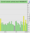
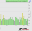
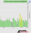
Based on the averages of all earthquakes during a given time interval in the last 24 hours we had a moderate seismic activity
See Global seismic activity level chart
As we can see in the graph, the average over the past 24 hours was approximately M5.9
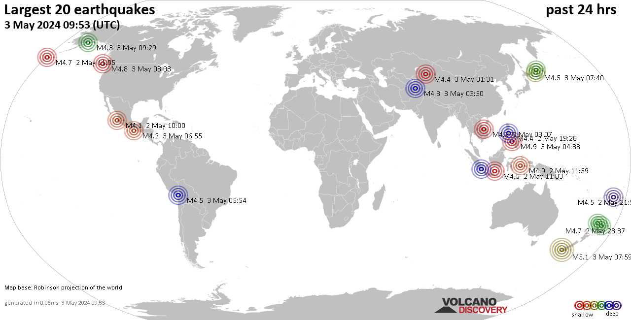
A strong magnitude 5.5 earthquake occurred in Easter Island Region.
▪︎M 5.5 - Easter Island region
2022-07-17 23:20:46 (UTC)
22.472°S 114.253°W
10.0 km depth
Two earthquakes hit Indonesia
▪︎M 5.1 - 151 km SSE of Pundong, Indonesia
2022-07-17 09:13:03 (UTC)
9.240°S 110.816°E. 38.7 km depth
▪︎M 5.2 - 64 km S of Gorontalo, Indonesia
2022-07-17 12:58:36 (UTC)
0.045°S 123.074°E. 115.9 km depth
▪︎Unusual earthquake in South Africa M 4.8 - 12 km ESE of Orkney, 2022-07-17 09:19:31 (UTC) 27.006°S 26.796°E. 10.0 km depth
▪︎M 4.2 - 2 km N of Filippiáda, Greece at 06:21:56 (UTC) 39.226°N 20.884°E. 10.0 km depth and M 4.1 - Western Turkey at 11:55:39 (UTC) 39.263°N 27.730°E. 10.0 km depth
Signs of building stress in that region
Quakes in the past 24 hours:
▪︎4 quakes above magnitude 5
▪︎40 quakes between magnitude 4 and 5
▪︎104 quakes between magnitude 3 and 4
▪︎237 quakes between magnitude 2 and 3
▪︎479 quakes below magnitude 2 that people normally don't feel.
▪︎857 quakes past 24 h. (873 earthquakes in the 24 hours prior to this report) Estimated combined seismic energy released: 4.6 x 10¹³ joules (12.8 gigawatt hours, equivalent to 11056 tons of TNT or 0.7 atomic bombs!)
Earthquake report past 24h
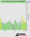
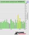
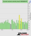
Based on the averages of all earthquakes during a given time interval in the last 24 hours we had a moderate seismic activity
See Global seismic activity level chart
As we can see in the graph, the average over the past 24 hours was approximately M5.9
A strong magnitude 5.5 earthquake occurred in Easter Island Region.
▪︎M 5.5 - Easter Island region
2022-07-17 23:20:46 (UTC)
22.472°S 114.253°W
10.0 km depth
Two earthquakes hit Indonesia
▪︎M 5.1 - 151 km SSE of Pundong, Indonesia
2022-07-17 09:13:03 (UTC)
9.240°S 110.816°E. 38.7 km depth
▪︎M 5.2 - 64 km S of Gorontalo, Indonesia
2022-07-17 12:58:36 (UTC)
0.045°S 123.074°E. 115.9 km depth
▪︎Unusual earthquake in South Africa M 4.8 - 12 km ESE of Orkney, 2022-07-17 09:19:31 (UTC) 27.006°S 26.796°E. 10.0 km depth
▪︎M 4.2 - 2 km N of Filippiáda, Greece at 06:21:56 (UTC) 39.226°N 20.884°E. 10.0 km depth and M 4.1 - Western Turkey at 11:55:39 (UTC) 39.263°N 27.730°E. 10.0 km depth
Signs of building stress in that region
Quakes in the past 24 hours:
▪︎4 quakes above magnitude 5
▪︎40 quakes between magnitude 4 and 5
▪︎104 quakes between magnitude 3 and 4
▪︎237 quakes between magnitude 2 and 3
▪︎479 quakes below magnitude 2 that people normally don't feel.
▪︎857 quakes past 24 h. (873 earthquakes in the 24 hours prior to this report) Estimated combined seismic energy released: 4.6 x 10¹³ joules (12.8 gigawatt hours, equivalent to 11056 tons of TNT or 0.7 atomic bombs!)
Earthquake report past 24h