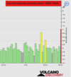
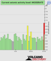
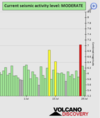
EARTHQUAKE REPORT PAST 24HRS
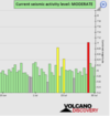
Based on the averages of all earthquakes during the last 24 hours we had a
moderate seismic activity.
See Global seismic activity level chart
Strong earthquakes have hit Russia region
▪︎M 5.6 - 13 km E of Mugur-Aksy, Russia
2022-07-29 13:01:13 (UTC)
50.396°N 90.623°E
10.0 km depth
USGS earthquake alert
▪︎M 5.2 - 170 km SE of Kuril’sk, Russia
2022-07-29 16:39:16 (UTC)
44.028°N 149.220°E
10.0 km depth
USGS earthquake alert
▪︎M 5.6 - 260 km SE of Vilyuchinsk, Russia
2022-07-29 23:05:43 (UTC)
51.193°N 160.956°E
10.0 km depth
USGS earthquake alert
Earthquake swarm hit Izu Japan region the strongest M5+
▪︎M 5.3 - Izu Islands, Japan region
2022-07-29 18:00:57 (UTC)
32.464°N 142.304°E
11.4 km depth
USGS earthquake alert
▪︎M 5.2 - Izu Islands, Japan region
2022-07-29 19:49:33 (UTC)
32.550°N 142.329°E
10.0 km depth
USGS earthquake alert
M 4.4 - Izu Islands, Japan region
2022-07-29 18:11:28 (UTC)
32.631°N 142.435°E. 10.0 km depth
M 4.6 - Izu Islands, Japan region
2022-07-29 18:16:33 (UTC)
32.514°N 142.495°E. 10.0 km depth
M 4.3 - Izu Islands, Japan region
2022-07-29 18:21:13 (UTC)
32.503°N 142.308°E. 10.0 km depth
M 4.3 - Izu Islands, Japan region
2022-07-29 19:22:37 (UTC)
32.501°N 142.691°E. 10.0 km depth
M 4.3 - Izu Islands, Japan region
2022-07-29 20:19:03 (UTC)
32.755°N 142.514°E. 10.0 km depth
M 4.7 - Izu Islands, Japan region
2022-07-29 20:42:27 (UTC)
32.562°N 142.414°E. 10.0 km depth
▪︎M 4.8 - 299 km SSE of Katsuura, Japan
2022-07-29 21:17:25 (UTC)
32.828°N 141.979°E. 10.0 km depth
Quakes in the past 24 hours:
~9 quakes above magnitude 5
~39 quakes between magnitude 4 and 5
~129 quakes between magnitude 3 and 4
~306 quakes between magnitude 2 and 3
~449 quakes below magnitude 2 that people normally don't feel.
~ 932 quakes past 24 h. (1023 earthquakes in the 24 hours prior to this report) Estimated combined seismic energy released: 8.3 x 10¹³ joules (23 gigawatt hours, equivalent to 19754 tons of TNT or 1.2 atomic bombs!)
Volcanodiscovery earthquake report 24h