WORLDWIDE EARTHQUAKE REPORT DECEMBER 09
Strong earthquakes in Philippines
An earthquake of magnitude 5.8 occurred 97 km northeast of Cabatuan, 98 km (pop: 2,380) Philippines. The quake hit at a shallow depth of 10 km beneath the epicenter early afternoon on Friday, December 9th, at 2:33 pm local time. The nearest volcano is Bulusan, 198km away from epicenter. Bulusan is one of the most active volcanoes in the Philippines.
● M 5.8 - 97 km NE of Cabatuan, Philippines
2022-12-09 06:32:59 (UTC)
13.168°N 125.834°E. 10.0 km depth
USGS earthquake alert
A second Strong earthquake hit early morning on Saturday, December 10th, at 4:01 am local time at a shallow depth of 10 km. The magnitude 5.6 earthquake occurred 13 km SE of Nangan (pop: 3,360). Leonard Range 112 km away is the nearest volcano. Currently the volcano is dormant. The last activity of Leonard Range probably occurred about 1800 years ago, indicated by radiocarbon dating of charred wood found in a pyroclastic flow deposit on the edge of the caldera
● M 5.6 - 2 km NE of Pondaguitan, Philippines
2022-12-09 20:01:56 (UTC)
6.381°N 126.192°E. 73.9 km depth
USGS earthquake alert
A magnitude 5.2 earthquake ocurred 149 km away from Ascensión volcano. Ascensión is the broad emergent summit of a massive stratovolcano that rises 3000 m above the sea floor. No eruptive activity has occurred since its discovery in 1501
● M 5.2 - 151 km ENE of Georgetown, Saint Helena
2022-12-09 17:08:25 (UTC)
7.171°S 13.270°W. 7.0 km depth
USGS earthquake alert
● M 5.1 - South Sandwich Islands region
2022-12-09 04:49:04 (UTC)
56.363°S 26.655°W. 38.1 km depth
USGS earthquake alert
Moderate magnitude 4.2 earthquake occurred 41 km (26 mi) NNW of Olymbos (pop: 400) Dodecanese, South Aegean, Greece, on Friday, Dec 9, at 8:44 pm. Nisyros volcano is 56 km away from epicenter.
According to Volcanodiscovery Nisyros is one of the more active but less known volcanoes in Greece. It is located south of the popular beach holiday island of Kos. The volcano is part of the Hellenic Arc, a curved line of volcanic centers which are caused by a subduction zone, and stretches from the Saronic Gulf opposite Athens via the island groups of Milos, Santorini, and Nisyros-Yali-Cos to the Bodrum peninsula at the extreme SW of Turkey.
● M 4.2 - Dodecanese Islands, Greece
2022-12-09 18:44:19 (UTC)
36.090°N 27.012°E. 11.1 km depth
USGS earthquake alert
● Summary
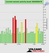
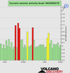
Seismic activity level has been at moderate levels in the last 24 hours. This is the last chart posted by Volcanodiscovery 02:00 UTC on December 09 Global seismic activity level chart
~4 quakes above magnitude 5
~39 quakes between magnitude 4 and 5
~86 quakes between magnitude 3 and 4
~202 quakes between magnitude 2 and 3
~419 quakes below magnitude 2 that people normally don't feel.
~750 earthquakes in the past 24h (894 earthquakes in the 24 hours prior to this report) Estimated combined seismic energy release: 11090 tons of TNT or 0.7 atomic bombs.
Volcanodiscovery earthquake report 24h
Strong earthquakes in Philippines
An earthquake of magnitude 5.8 occurred 97 km northeast of Cabatuan, 98 km (pop: 2,380) Philippines. The quake hit at a shallow depth of 10 km beneath the epicenter early afternoon on Friday, December 9th, at 2:33 pm local time. The nearest volcano is Bulusan, 198km away from epicenter. Bulusan is one of the most active volcanoes in the Philippines.
● M 5.8 - 97 km NE of Cabatuan, Philippines
2022-12-09 06:32:59 (UTC)
13.168°N 125.834°E. 10.0 km depth
USGS earthquake alert
A second Strong earthquake hit early morning on Saturday, December 10th, at 4:01 am local time at a shallow depth of 10 km. The magnitude 5.6 earthquake occurred 13 km SE of Nangan (pop: 3,360). Leonard Range 112 km away is the nearest volcano. Currently the volcano is dormant. The last activity of Leonard Range probably occurred about 1800 years ago, indicated by radiocarbon dating of charred wood found in a pyroclastic flow deposit on the edge of the caldera
● M 5.6 - 2 km NE of Pondaguitan, Philippines
2022-12-09 20:01:56 (UTC)
6.381°N 126.192°E. 73.9 km depth
USGS earthquake alert
A magnitude 5.2 earthquake ocurred 149 km away from Ascensión volcano. Ascensión is the broad emergent summit of a massive stratovolcano that rises 3000 m above the sea floor. No eruptive activity has occurred since its discovery in 1501
● M 5.2 - 151 km ENE of Georgetown, Saint Helena
2022-12-09 17:08:25 (UTC)
7.171°S 13.270°W. 7.0 km depth
USGS earthquake alert
● M 5.1 - South Sandwich Islands region
2022-12-09 04:49:04 (UTC)
56.363°S 26.655°W. 38.1 km depth
USGS earthquake alert
Moderate magnitude 4.2 earthquake occurred 41 km (26 mi) NNW of Olymbos (pop: 400) Dodecanese, South Aegean, Greece, on Friday, Dec 9, at 8:44 pm. Nisyros volcano is 56 km away from epicenter.
According to Volcanodiscovery Nisyros is one of the more active but less known volcanoes in Greece. It is located south of the popular beach holiday island of Kos. The volcano is part of the Hellenic Arc, a curved line of volcanic centers which are caused by a subduction zone, and stretches from the Saronic Gulf opposite Athens via the island groups of Milos, Santorini, and Nisyros-Yali-Cos to the Bodrum peninsula at the extreme SW of Turkey.
● M 4.2 - Dodecanese Islands, Greece
2022-12-09 18:44:19 (UTC)
36.090°N 27.012°E. 11.1 km depth
USGS earthquake alert
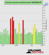
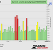
● Summary
Seismic activity level has been at moderate levels in the last 24 hours. This is the last chart posted by Volcanodiscovery 02:00 UTC on December 09 Global seismic activity level chart
~4 quakes above magnitude 5
~39 quakes between magnitude 4 and 5
~86 quakes between magnitude 3 and 4
~202 quakes between magnitude 2 and 3
~419 quakes below magnitude 2 that people normally don't feel.
~750 earthquakes in the past 24h (894 earthquakes in the 24 hours prior to this report) Estimated combined seismic energy release: 11090 tons of TNT or 0.7 atomic bombs.
Volcanodiscovery earthquake report 24h
 .
.