WORLDWIDE EARTHQUAKE REPORT DECEMBER 18
● A shallow magnitude 5.1 earthquake was reported in the evening 34 km (21 mi) WSW of Santa Cruz (pop: 26,400) Luzon Island Philippines, the quake hit on Sunday, December 18th, 2022, at 9:33 pm local time
Pinatubo is the nearest volcano located 100 km away from epicenter. Pinatubo volcano exploded spectacularly on 15 June 1991. Little was known of Pinatubo volcano as it had been dormant for 400 years. There were no known historic eruptions before the eruption in 1991
M 5.2 - 30 km WSW of Bolitoc, Philippines
2022-12-18 13:33:46 (UTC)
15.680°N 119.600°E. 10.0 km depth
USGS earthquake alert
● A magnitude 5.1 quake in Japan 124 km (77 mi) WNW of Naha (pop: 300,800) Shi, Okinawa, Japan. The earthquake hit in the afternoon on Sunday, December 18th at 4:01 pm local time at an intermediate depth of 115 km.
M 5.1 - 124 km WNW of Naha, Japan
2022-12-18 07:01:52 (UTC)
26.770°N 126.599°E. 114.1 km depth
USGS earthquake alert
● Kandilli Oservatory and Earthquake Research Institute in Istanbul (KOERI-RETMC), reported a magnitude 4.7 earthquake 9 km (5 mi) E of Uzunkavak (pop: 1,010) Turkey-Syria border region. Koruhüyügü is the nearest volcano located 52 km away from epicenter. The current status of this volcano is dormant.
M 4.7 - Turkey-Syria border region
2022-12-18 18:13:09 (UTC)
36.348°N 36.518°E. 10.0 km depth
USGS earthquake alert
● Light magnitude 4.5 earthquake occurred in Aegean Sea, 38 km southeast of Sykia, Chalkidiki, Central Macedonia, Greece, on Sunday, Dec 18, 2022 at 7:01 am local time.
M 4.5 - 35 km SE of Sykiá, Greece
2022-12-18 05:01:13 (UTC)
39.804°N 24.230°E. 16.6 km depth
USGS earthquake alert
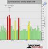
● Summary
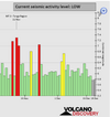
Seismic activity level has been at low levels in the last 24 hours. This is the last chart posted by Volcanodiscovery at 01:00 UTC on December 17 Global seismic activity level chart
~2 quakes above magnitude 5
~39 quakes between magnitude 4 and 5
~87 quakes between magnitude 3 and 4
~239 quakes between magnitude 2 and 3
~493 quakes below magnitude 2 that people normally don't feel.
~860 earthquakes in the past 24h (756 earthquakes in the 24 hours prior to this report) Estimated combined seismic energy release: 5362 tons of TNT or 0.3 atomic bombs
Volcanodiscovery earthquake report 24h
● A shallow magnitude 5.1 earthquake was reported in the evening 34 km (21 mi) WSW of Santa Cruz (pop: 26,400) Luzon Island Philippines, the quake hit on Sunday, December 18th, 2022, at 9:33 pm local time
Pinatubo is the nearest volcano located 100 km away from epicenter. Pinatubo volcano exploded spectacularly on 15 June 1991. Little was known of Pinatubo volcano as it had been dormant for 400 years. There were no known historic eruptions before the eruption in 1991
M 5.2 - 30 km WSW of Bolitoc, Philippines
2022-12-18 13:33:46 (UTC)
15.680°N 119.600°E. 10.0 km depth
USGS earthquake alert
● A magnitude 5.1 quake in Japan 124 km (77 mi) WNW of Naha (pop: 300,800) Shi, Okinawa, Japan. The earthquake hit in the afternoon on Sunday, December 18th at 4:01 pm local time at an intermediate depth of 115 km.
M 5.1 - 124 km WNW of Naha, Japan
2022-12-18 07:01:52 (UTC)
26.770°N 126.599°E. 114.1 km depth
USGS earthquake alert
● Kandilli Oservatory and Earthquake Research Institute in Istanbul (KOERI-RETMC), reported a magnitude 4.7 earthquake 9 km (5 mi) E of Uzunkavak (pop: 1,010) Turkey-Syria border region. Koruhüyügü is the nearest volcano located 52 km away from epicenter. The current status of this volcano is dormant.
M 4.7 - Turkey-Syria border region
2022-12-18 18:13:09 (UTC)
36.348°N 36.518°E. 10.0 km depth
USGS earthquake alert
● Light magnitude 4.5 earthquake occurred in Aegean Sea, 38 km southeast of Sykia, Chalkidiki, Central Macedonia, Greece, on Sunday, Dec 18, 2022 at 7:01 am local time.
M 4.5 - 35 km SE of Sykiá, Greece
2022-12-18 05:01:13 (UTC)
39.804°N 24.230°E. 16.6 km depth
USGS earthquake alert
● Summary
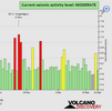
Seismic activity level has been at low levels in the last 24 hours. This is the last chart posted by Volcanodiscovery at 01:00 UTC on December 17 Global seismic activity level chart
~2 quakes above magnitude 5
~39 quakes between magnitude 4 and 5
~87 quakes between magnitude 3 and 4
~239 quakes between magnitude 2 and 3
~493 quakes below magnitude 2 that people normally don't feel.
~860 earthquakes in the past 24h (756 earthquakes in the 24 hours prior to this report) Estimated combined seismic energy release: 5362 tons of TNT or 0.3 atomic bombs
Volcanodiscovery earthquake report 24h


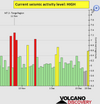
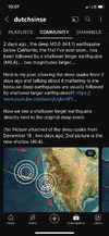
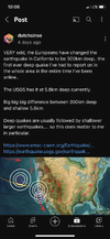
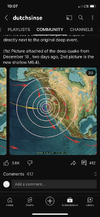
 ) going on under NorCal: