Fires around the world

13.08.2018 - Fire forces evacuations on Greek island of Evia
Fire forces evacuations on Greek island of Evia

file71fcn8115d4hip2ucq6_0.jpg

The burning forest fire that break out in Psachna, island of Euboea, Greece, on Aug 12, 2018. PHOTO: EPA-EFE


A large fire broke out Sunday on the Greek island of Evia near Athens, the government said, with two villages evacuated, less than a month after over 90 people died in Greece's worst-ever wildfire.

"The prime minister is in close contact with the interior minister over the large fire in Evia," Prime Minister Alexis Tsipras' office said.

Agriculture minister Vangelis Apostolou, who is on the scene, told state agency ANA that fire-fighting forces were bracing for an all-night struggle.

"Forces from the entire region have been transfered here," Apostolou said.

Some 500 people at the local villages of Kontodespoti and Stavros had earlier been evacuated as a precaution.

Some 250 firefighters with 62 fire engines supported by troops are operating in the area, about 92 kilometres (57 miles) north of Athens, officials said.

186 people and more than 70 units of equipment, including five helicopters and six aircrafts are involved in the elimination of wildfires.

Greece is still mourning 94 dead from a wildfire that struck the coastal resort of Mati near Athens on July 23. Over 30 people are still in hospital, several in critical condition.

The country's worst fire calamity prompted the resignation or sacking of the heads of the police and fire brigade, in addition to the minister responsible for state security.
 
  • Like
Reactions: Ca.
It is another tough and tragic year for so many - fire is all around us here and there, and I've not seen the clear sun and stars in weeks through the smoke. This is not new and it will keep happening.

I'm throwing in these two photo examples that represent two different snapshots in time of the mountain landscapes in BC and Alberta (where there are many fires going on at the moment). As mentioned prior in a post, and all over the world, there are these cycles of forest rotation - or, from historically sparse vegetation to heavy connected forest canopies of growth and fuel, which are influences for many fires we see today during return intervals.

In the photo (have a good look), it is interesting to note that in 1915 the valley bottoms were generally sparse and the slopes had little in the way of growth (and soil) - yet there are pockets that you can see and different age classes of trees. Was this particular valley hit by fire well before? This would leave signatures, and there will be some. If, though, fire was a constant (without suppression), and without dense canopy, the fires would move fast in the grasses and shrubs - producing a flash fire, a spike in nitrogen, and even leaving these treed pockets to continue in growth - generally there is a quick recovery and not like these hot fires (and their behavior) in dense forests we see that tend to cook-off soils and even crack rock under the right conditions.

If old photos in whatever area are reviewed, this will likely appear in one form or another.

In California, for instance, have a read from a resent post by Larry Hamlin discussing articles in the newspapers and Gov. Brown's statements:

Gov. Brown said:
“The more serious predictions of warming and fires to occur later in the century, 2040 or 2050, they’re now occurring in real time,” Brown said at a news conference at the state’s emergency operations center outside Sacramento.”
“Brown, who met with top fire and emergency response officials, said the state would spend whatever is needed to combat the blazes. But he said the current conditions are part of a long cycle that began with the rapid rise in greenhouse gases caused by human activity.”
Brown is selling fear pointing anthropogenically at a gas. The overall message in Hamlin's piece (arguments against the MSM, notwithstanding the AGW hoax) is the historic forest policies of fire suppression. This is true, and yet obviously when people interface in forests - across vast landscapes as they have today, forests that are grown in and at the top end of their peak cycle (density of fuel), they are not about to stand back without attempts at suppression. The one problem is, nature is vastly more potent then we can respond to, and fires in these current fuel conditions are simply going to take things out - anything in its path.

Hamlin said:
The Gov. has made these flawed claims before as noted below even though the states forest management policy leadership had clearly identified the failure of a century long practice of unnatural wildfire suppression policies that has allowed the built up huge amounts of wildfire fuel materials that were greatly increasing the risks for more dangerous and damaging wildfires.


For instance, having read that the population of Redding California (recent fire) is a little less than a 100,000 people today, a hundred years ago it was around 600 people - with little road connectivity or houses build-up in the forests. A fire then would not necessarily make the news and it would burn and then it would go out naturally; yet that all changed.

When fire hit the town of Fort McMurray in 2016, this town was centered adjacent to a dense forest canopy with little breaks. Back in 1915 that town did not exist (let alone the forest density itself). When those communities in Greece tragically burned just recently, these communities were likely not there in 1915 in the same form and layout. In Greece, it was not forest fuels per se, it was the dry grasses, winds and connectivity of dwellings the influenced its spread to the horrible result.

It is understandable that when people's homes and lives are threatened, they want answers, they need something to blame, and they want someone to step forward and solve it - to suppress the problems. However, the problems are many as people know.

Today, we also seem to have more intense electrical discharging going on, underground gasses rising, intense period of heat (and drying winds and even their directions) and also its opposite. There are changes to our atmospheres at high levels (including comet dust loading), and it all has nothing to do with a trace C02 gas (that's the blame game focus). Today, we also have peak combustible landscape level fuels, mass interfacing of people over the landscapes on a planet undergoing changes from deep within and without that appears to be running its course until things settle. This can't be suppressed by man as the universe also seems to have other plans, and yet as Pierre discusses in his book 'Earth Changes and the Human Cosmic Connection' the connections seem to be there on many levels.

I guess the only thing to add is that whether we live adjacent to rivers, oceans, lowlands, forests, rock, snow or steep slopes, if you look carefully at the landscapes signs, it will usually reveal what has happened before as extreme signatures of the cycles and intervals that may possibly be used to help avoid, if recognized and acknowlaged.

1534614163624.png
 
For a couple of years I have been following Deborah Tavares and her site StopTheCrime.net. The correlation of these fires (and other disasters) and agenda 21seems quite plausible as is the use of directed energy weapons, at the very least in the US case. Also a YT channel titled aplanetruth covers a lot of concerns and curiosities about the fires, namely the reasons and causes behind the fires and their strange aftermath. Just wondering if anyone else has looked into this?
 
August 20, 2018 - Shocking NOAA interactive map reveals almost two MILLION acres of land is on fire across the United States
Shocking NOAA interactive map reveals two MILLION acres of land is on fire across the United States | Daily Mail Online

The West Coast of the United States is shrouded in smoke from the 110 large fires
  • Over 1.9 million acres are or have been ablaze, with new fires reported in Idaho, Nevada and Oregon
  • Smoke from these fires has traveled along the west to east jet stream to reach the East Coast
The full extent of the wildfires ravaging the West Coast of the US has been revealed.

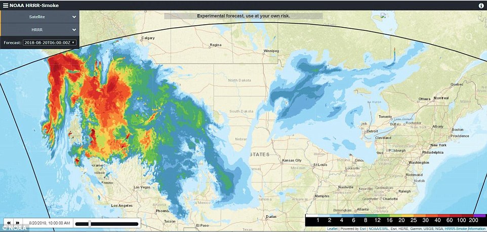
An experimental map created by the NOAA shows the current movement of the smoke across the U.S.

The West Coast of the United States is shrouded in smoke from the 110 large fires (this does not include smaller fires within each complex of fires) that have erupted across the region during this fire season.

Scroll down for video and click here to access an interactive map.

4F3D294600000578-0-image-a-2_1534782555949.jpg


HOW THE MAP WAS MADE
This map (10am EDT on August 20, 2018) comes from NOAA and is an experimental model showing both upper level on near-surface smoke.

This particular iteration of the map is showing the near-surface smoke (expressed in μg/m3) from the HRRR-Smoke Model.

The Near-Surface Smoke overlays 10-meter wind data, expressed in knots.

The colors represent the fire emitted fine particulate matter (fire smoke) concentrations at ~8 meters above the ground.

The darker and redder the color the more concentration of smoke particulates are present.

It is interesting to see how the smoke moves across the country traveling south as far as Texas and east as far as Quebec.

When wind patterns change, of course, so does the smoke pattern.

WTOP, a local radio station near Washington DC, reported that smoke from the California fires had reached the DC Metro area this past week.
 
Camp Fire near Chico: California wildfire spreads to 8,000 acres; thousands evacuated
12:37 pm PST, Thursday, November 8, 2018 Pic's (Image 1 of 19)


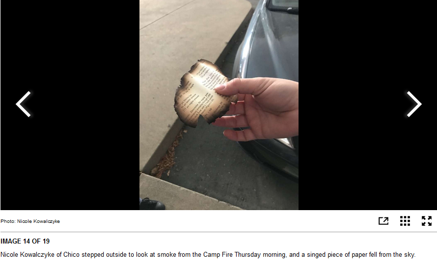
Thousands of people were ordered to evacuate several Sierra foothills towns near Chico on Thursday as a wildfire raged out of control, growing rapidly to more than 6,000 acres.

“Multiple” structures have burned, said Scott McLean, a spokesman with the state Department of Forestry and Fire Protection, or Cal Fire. There was no immediate word on whether anyone had been injured.

The blaze, dubbed the Camp Fire, started in the area of Camp Creek Road and Pulga Road near Highway 70 in the Feather River Canyon, said Cal Fire officials said.

The Butte County towns of Pulga and Concow and most of Paradise were evacuated shortly after the fire started about 6:30 a.m. All areas of Paradise except Lower Neil Road are under mandatory evacuation orders, according to the California Highway Patrol.

Skyway Road is closed as of 9:40 a.m., CHP officials said, and residents are being asked to evacuate using alternate roads. Caltrans announced at 9:57 a.m. that officers had shut down Highway 70 south of the fire, extending down to northbound Highway 149.

The Paradise Unified School District and Butte College closed their doors Thursday morning under evacuation orders from fire officials. Feather River Hospital in Paradise was also being evacuated as of 9 a.m. The fire had jumped a road leading to the hospital.

As of noon, Pacific Gas and Electric Co. reported that 34,280 customers in Butte County and neighboring Plumas had lost power. The outages began at 7:45 a.m. near Big Bend and Concow, PG&E spokesman Paul Moreno said.

People took to social media to plead for evacuation help for elderly residents of Paradise, which is home to many retirees. The Butte County Sheriff’s Office tweeted that deputies were trying to reach trapped people.

The fire has sent dark clouds of smoke over Chico and as far south as the Bay Area.

A smoke advisory has been issued for the Bay Area through Friday, air district officials said. Residents may see or smell smoke from the Camp Fire.

Nearly 27,000 people call Paradise home. The incorporated town is about 10 miles east of Chico in the foothills north of Sacramento.

Pulga and Concow are both small, rural unincorporated communities in Butte County. Concow has about 710 residents. Pulga had two residents when it was sold in 2015, according to media reports.

Several shelters have opened in Butte County to accommodate evacuees:

•Oroville Nazarene Church at 2238 Monte Vista Avenue. in Oroville

•Neighborhood Church at 2801 Notre Dame Boulevard in Chico

•East Ave Church at 1185 East Avenue in Chico

•Butte County Fairgrounds at 199 East Hazel Street in Gridley

•The Old County Hospital at 2279 Del Oro Ave. in Orovile is accepting small animals


The smoke from the Paradise, CA fires reached Sonoma County today. It was so smoky, I had difficulty breathing. You could not see the sun until late afternoon. The winds picked up for most of the day. The haze remained. It's very unsettling. Brings back memories of last years fires that were literally in my neck of the woods.

Prayers for the people fleeing the firestorm and for those First Responders who are battling it.


Chico Enterprise-Record
10 p.m. update: Up to 1,000 homes burn, multiple deaths in Paradise from Camp Fire; east Chico being evacuated – Chico Enterprise-Record
November 08, 2018, 10:26 pm Video Facebook Tweets
PARADISE, Ca. -
The fast-moving Camp Fire burned up to 1,000 buildings and homes in the Paradise area Thursday and reportedly killed multiple people, then roared into Chico and forced evacuations there.

Cal Fire-Butte County Chief Darren Read said in the afternoon that hundreds of structures in Paradise have burned, perhaps as many as 1,000. Butte County Sheriff Kory Honea said there are reports of multiple fatalities, and authorities are trying to verify how many.

The fire started in the Feather River Canyon near Pulga and Highway 70, then burned west. It jumped to 18,000 acres in eight hours Thursday, ripping across the Concow Valley and into and across Paradise.

Then the fire turned east. It reached Highway 99 near Neal Road by 7:30 p.m. and was approaching Highway 32 near upper Bidwell Park by 9 p.m. Evacuation orders were issued from Bruce Road east, from East 20th Street to Highway 32 along the east side of Chico, and in the Canyon Oaks subdivision farther north. Homes were reported burning on the lower Skyway near Oak Ridge Drive and Spanish Garden Drive.

Tens of thousands had already been evacuated, perhaps as many as 50,000 people, according to the sheriff. The Sheriff’s Office also has received hundreds of calls requesting deputies to perform welfare checks on unaccounted people in the fire zone. Officials expected to work through the night responding to those calls.

“This was a rapidly moving fire,” Honea said. “And it moved very very quickly from a rather remote area to populated areas.”

Honea said he had no estimate when evacuees would be able to return.

Residents in Paradise, Magalia, Concow, Yankee Hill and Butte Creek Canyon were initially ordered to evacuate. Thursday evening the evacuation order was extended from Forest Ranch south to Chico, and later to Cherokee and Oro-Chico Highway near Durham. Then the east Chico evacuations were ordered, followed by an order covering everything north of Highway 70 and east of Highway 149

Three firefighters and several citizens were taken to hospitals with injuries. Three more firefighters suffered burns.

The fire started about 6:30 a.m. Thursday at Camp Creek Road near Pulga. Read said the cause of the fire is under investigation, and likely would be for “quite some time.”

Around 2:30 p.m., Cal Fire said 20,000 acres had burned with no containment. The fire was exhibiting extreme fire behavior, Cal Fire public information officer Rick Carhart said. Firefighters are expecting sustained winds up to 30-35 mph on the fire.

“This fire did move through the town of Paradise quickly,” said Paradise Police Chief Eric Reinbold. “We’re very grateful for our partnerships with allied agencies, Cal Fire, our agency, the town staff worked as quickly as possible to evacuate, using our evacuation plans. And the things that we’ve trained for over the years. There is a lot of devastation in town. Just to reiterate, we can’t confirm how many structures, but at this point it’s very devastating to the town.’

Chaos on the ground

Witnesses and reporters on the ground described a chaotic scene as people tried to leave town.

The fire moved so fast that people were cut off by the flames and sheltered in large asphalt parking areas. Radio traffic Thursday afternoon indicated 300 people were at the Kmart lot on Clark Road, with fire in all directions. Another 100 were at a storage business at Clark and Skyway. Still another group gathered at the Holiday Market parking lot on Skyway.

Photographer Karl Mondon said at 4 p.m. the Safeway parking lot at Clark and Elliott roads was half full of evacuees. Many said they knew their homes were lost.

Wayne and Juanita McLish, 20-year residents of Fawndale Lane, said they fought for two hours to save their home until the water pressure ran out, then made it to Safeway. Wayne McLish’s face was covered in soot. The former math teacher looked stunned when he was told it was 4 o’clock in the afternoon, not the morning.

Evacuees who were able to get out of town often found themselves in gridlock. A pregnant woman stuck in traffic went into labor. In the late morning, Highway 99 northbound was clogged from south of Durham-Pentz Road to Chico. A number of people took a U-turn across the median to get off the freeway at Durham-Pentz and head toward Durham, but the Midway was backed up northbound as well.

Hospital evacuated

According to the Sheriff’s Office, Feather River Hospital and all Paradise schools were all evacuated. Hospital patients were sent to Enloe Medical Center in Chico and Oroville Hospital.

According to PG&E spokesman Paul Moreno, 32,000 customers were without power as a result of the fire in Butte and Plumas counties, which includes those in the Paradise, Pulga and Concow areas. No public safety power shut off has been implemented.

The county set up evacuation centers at Oroville Nazarene Church (2238 Monte Vista Ave.) and Neighborhood Church in Chico (2801 Notre Dame Blvd.), but both of those were reported full Thursday evening. Another shelter at the Butte County Fairgrounds in Gridley still had space. At 8:30 p.m. Thursday, another shelter was opened at the Chico Elks Lodge (1705 Manzanita Ave.).

The Silver Dollar Fairgrounds is being used as a staging area for fire crews and is not open to evacuees. Butte College is also being used as a staging area.

The city of Chico’s Public Works Department said evacuees can also head to DeGarmo Park and Community Park off 20th Street in Chico, as well as Durham Park, but not to expect services.

Camp Fire evacuees are being asked to register with Red Cross’ Safe & Well website so concerned family and friends can search those lists. Safe & Well Concerned family and friends can also search the list of those who have registered as “safe and well” by clicking on the “Search Registrants” button.

The California Governor’s Office of Emergency Services (Cal OES) has activated the State Operations Center to provide assistance to Butte County in support of the Camp Fire.

Cal OES Fire, Law Enforcement, and Inland Region personnel are currently working with various response agencies to address all emergency management, evacuation and mutual aid needs.

Smoke from the fire was reported as far away as San Jose and Fort Bragg.
 
Last edited:
Mega Tweet's

Southern California

Hill and Woolsey fires force evacuations in Ventura, LA counties — structures burn in Oak Park – Daily News
UPDATED: November 9, 2018 at 1:22 am Tweet's Maps Alerts Pic's
A fast-moving brush fire fueled by strong, erratic winds and low humidity charred as many as 7,000 acres Thursday in the Newbury Park-Thousand Oaks area, forcing evacuations and shutting down a section of the 101 Freeway as scores of firefighters, aided by air tankers, worked to quell the flames.

Related: This map shows where the Hill fire and Woolsey fire are burning

The Hill fire broke out sometime around 2 p.m. in the Santa Rosa Valley near Santa Rosa Road, according to Ventura County Fire Department officials. Capt. Brian McGrath said that by 3 p.m., the blaze had quickly burned through thousands of acres near the border of Newbury Park and Thousand Oaks.

The Woolsey fire, in the meantime, was burning structures late Thursday and evacuation orders were issued for Oak Park, a community near the Los Angeles County border; and for a nearby section of Los Angeles. Also evacuated early Friday were parts of Bell Canyon and Thousand Oaks.

And a new fire broke out near the 118 Freeway in the Simi Valley area, prompting closure of eastbound lanes early Friday.

Chad Cook, Assistant Chief for the Ventura County Fire Department, said that by Thursday night the Hill fire had burned between 5,000 and 7,000 acres.

Cook said the fire started in the Hill Canyon area and was “pushed by an east wind and crossed the 101 Freeway in about 12 minutes.”

McGrath said the flames threatened homes and prompted mandatory evacuations in the Camarillo Springs Area. Affected residents were being directed to the Borchard Community Center, 190 Reino Road, according to social media updates from firefighters. McGrath said it was not immediately clear how many people had been displaced

The fire department issued mandatory evacuation notices while a voluntary evacuation notice was issued for the Point Mugu Naval Base.

Ventura County fire said the Rancho Santa Susana Recreation Center, along with the Borchard and Camarillo Community Centers were evacuation centers


Twenty-mile-per-hour winds whipped through the area as 165 firefighters battled the fire with support from eight air tankers in the afternoon. Cook said roughly 500 firefighters were working the fire as of 8 p.m., with many more available.

“We don’t have any confirmed commercial or residential structure loss, but we have lost trailers,” Cook said.

Officials said the Hill fire was expected to follow the same trail as the Springs fire in May 2013 fire that burned around 24,000 acres, and make its way to Pacific Coast Highway.

“The first part of this fuel bed, where the fire started, hadn’t seen fires in many years,” Cook said.

The nearby Hill Canyon Waste Water Treatment Plant and Viceto Trailer park were some of the first places evacuated, according to social media posts from Ventura County firefighters.

A closure of a portion of the 101 was ordered at 2:50 p.m. and by 3:40 p.m. it was shut down from Lewis Road to Route 23, according to California Highway Patrol Officer James Miconi.

CSU Channel Islands also ordered a mandatory evacuation of the campus due to fire. All classes and activities were canceled Thursday evening, a school official said, and students who live on campus have been asked to evacuate and go home, stay with a friend or head north of the campus.

Also burning in the region was the Woolsey fire, which had charred more than 2,000 acres in the Woolsey Canyon area of Ventura County, CalFire officials said. Los Angeles County firefighters were assisting with that blaze.

Oak Park was ordered evacuated and by early Friday the evacuations extended into part of Los Angeles County.

Evacuation centers were pending, but Pierce College was open for evacuations of large animals.

The Los Angeles County Sheriff’s Department said residents of Calabasas, Hidden Hills and Agoura Hills should prepare for evacuations.

Both the Hill and Woolsey fires also resulted in the Ventura County Office of Education cancelling classes for a host of schools throughout the area, including all schools in the Conejo Valley Unified, Hueneme Elementary, Las Virgenes, Mesa Union, Oak Park Unified, Oxnard Elementary, Oxnard Union High, Pleasant Valley, Rio and Somis Union School Districts.

Several Ventura County charter schools also cancelled Friday classes, including ACE Charter High School, Bridges Charter School, River Oaks Academy and Vista Real Charter High School.

The Ventura County Office of Education also closed several other schools and sites for Friday, including the ACCESS School, Dean Triggs School, Dwire School, Gateway Community School, Hathaway Preschool, James Foster School, La Mariposa Elementary School, Las Colinas Middle School, the VCOE classroom at Moorpark High School, Phoenix-Airport, Phoenix-Los Nogales, Phoenix-Moorpark, Pleasant Valley Early Childhood Center, Ritchen Preschool, Sunkist School and Williams Preschool.

“Prepare a bag containing your ID, meds, important documents, emergency supplies and a change of clothes,” the sheriff’s department said on Twitter.

 
I 20181109_074325.jpgcan see some wild fires from behind my building... it still very windy here in San Fernando Valley
 

Attachments

  • 20181109_123553.jpg
    20181109_123553.jpg
    553.8 KB · Views: 5
  • 20181109_123544.jpg
    20181109_123544.jpg
    933.5 KB · Views: 5
Paradise Is On Fire

Amid all the horrible news and footage the town "Paradise" rang a bell for me.

Could this be just another sign by the Universe to let us know the state of affairs, when even a place by the name of Paradise ist destroyed by fire?

Paradise is devastated, everything is destroyed." It’s destroyed parts of the Sierra foothills, including the town of Paradise, officials say.

Wildfire Decimates California Town

"In one particularly harrowing video shared to Facebook by Brynn Parrott Chatfield, viewers are treated to a first-person view of Chatfield driving through what looks like a tunnel of fire. This isn't an exaggeration: The effect is it looks as if Chatfield were driving through the Gates of Hell itself."

Article by Zero Hedge

 
Paradise Is On Fire

Amid all the horrible news and footage the town "Paradise" rang a bell for me.

Could this be just another sign by the Universe to let us know the state of affairs, when even a place by the name of Paradise ist destroyed by fire?


Wildfire Decimates California Town

"In one particularly harrowing video shared to Facebook by Brynn Parrott Chatfield, viewers are treated to a first-person view of Chatfield driving through what looks like a tunnel of fire. This isn't an exaggeration: The effect is it looks as if Chatfield were driving through the Gates of Hell itself."

Article by Zero Hedge


I have to say, I was thinking the same thing when I heard of it, especially after seeing that video. A very strange juxtaposition, and tragic besides.
 
Southern California
Hill and Woolsey fires force evacuations in Ventura, LA counties — structures burn in Oak Park – Daily News
UPDATED: November 9, 2018 at 1:22 am Tweet's Maps Alerts Pic's
A fast-moving brush fire fueled by strong, erratic winds and low humidity charred as many as 7,000 acres Thursday in the Newbury Park-Thousand Oaks area, forcing evacuations and shutting down a section of the 101 Freeway as scores of firefighters, aided by air tankers, worked to quell the flames.

I wasn't sure at first but this is the same Thousand Oaks where the recent mass shooting occurred:

‘It Really Can’t Get Much Worse’: Thousand Oaks, First Hit by Shooting, Now Faces Fire
 
Last edited:
This is the third time in 13 months we Northern Californians have been told that the ongoing fire is the most destructive fire on record. No, wait, the Ranch fire just a few months ago was the largest in CA history. Any ideas why multiple fires start at often exactly the same time in different areas?
 
  • Like
Reactions: Joe
Back
Top Bottom