CHINA / SOCIETY By Global Times Published: Feb 23, 2023 01:52 PM
Update: Six found dead, 47 missing after massive accident in N.China’s Inner Mongolia
Coal mine collapse under investigation; related personnel controlled
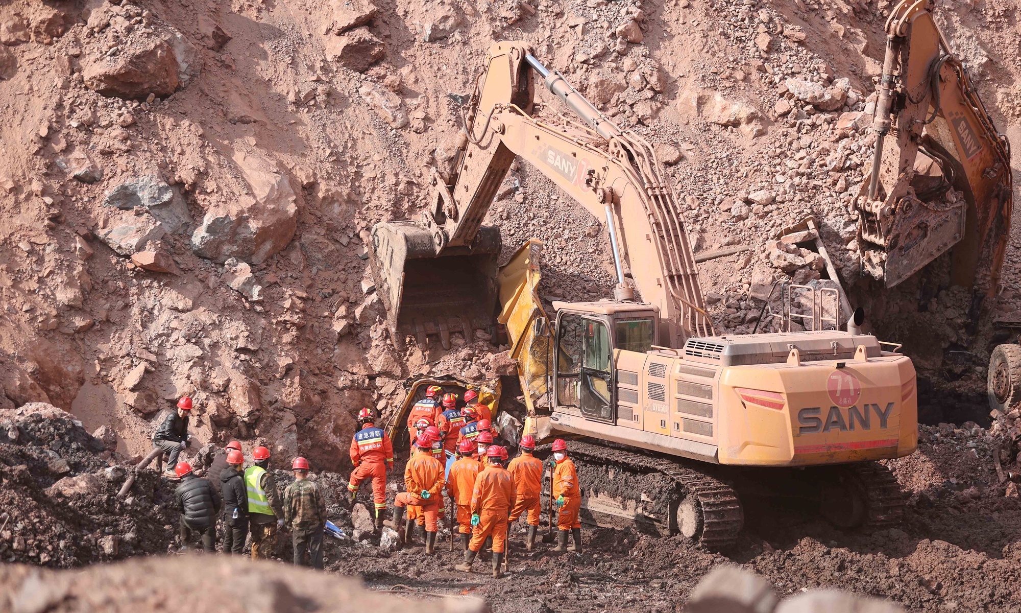
Rescuers on the site of the collapsed coal mine in Alxa league, North China's Inner Mongolia on February 23, 2023. Photo: Xinhua
Rescuers recovered one more victim from the debris, bringing the total deaths to six with 47 missing as of Thursday night, after a massive open-pit coal mine collapsed in North China's Inner Mongolia Autonomous Region on Wednesday. China's Ministry of Emergency Management ordered a full rescue and thorough investigation of the cause of and responsibility for the accident.
The coal mine in Alxa Left Banner, Alxa league, Inner Mongolia,
collapsed at around 1 pm Wednesday. An employee told media on Wednesday that the mine had about 600 employees.
National broadcaster CCTV reported that the specific cause of the collapse is under further investigation. As the public security organs have become involved in the investigation, the relevant personnel have been put under control, and the follow-up will be announced in due course.
CCTV reported that the six people rescued on Wednesday were receiving treatment at a hospital in Qingtongxia, Northwest China's Ningxia Hui Autonomous Region, and their conditions were not life-threatening.
Ma Jianping, one of the injured, was quoted by the report as saying that at around 1:15 pm on Wednesday he found that the slags were falling from the mountain, and then saw that the situation was more and more serious. Although they were immediately organized to evacuate, it was too late to leave before the collapse.
Through overnight investigation and assessment, the expert group on Thursday developed an optimized rescue plan, and all search and rescue personnel, medical staff and ambulances were in place.
Wang Xiangxi, minister of emergency management, arrived at the scene at 1 am Thursday, inspected the site in detail and learned about the rescue and disposal situation. Wang said the rescue work must be carried out in full force, according to the official statement released by the Ministry of Emergency Management on Thursday evening.
The ministry urged the investigation to be carried out seriously and pursue responsibilities in accordance with the law.
As of 6 am Thursday, more than 900 personnel had rushed to the site for rescue operations, the Xinhua News Agency reported.
Experts from the central authorities, the autonomous region and other relevant provinces and regions had arrived at the rescue site.
The rescue operation is complex, as the mining area is located within a valley. After the collapse, the bottom of the operation surface was basically buried.
The incident occurred in the western section of the coal mine. The mountain slope in the western mining area collapsed. After the collapse, it formed a mound of dirt that ran 500 meters east to west and 200 meters north to south.
Video footage from the mine's cameras showed that the collapse occurred at around 1 pm and lasted for about 30 to 40 seconds. At about 6:44 pm, a second major landslide occurred at the site and halted search and rescue efforts.
In order to ensure the safety of the rescue workers, according to the advice of the expert group, all the rescue workers and vehicles were then evacuated to a safe area. The expert group carried out on-site assessments overnight, formulated an optimized rescue plan, and then organized the rescue.
All the rescue forces have been put in place, medical rescue forces and ambulances have been prepared, and the power supply and communication support for the on-site emergency command has been put in place.
The mine was originally a closed site, but in 2012 it was transformed into an open-pit mine. Production resumed in April 2021 following a three-year suspension.
Wang Hongwei, a professor at the Renmin University of China's School of Public Administration and Policy, told the Global Times on Thursday that as the area of the collapse almost covered the whole slope of the mine, removing the large amount of earth in the short term would be very challenging.
Plus, the collapsed area is located in a V-shaped valley, so there was less opportunity for miners to escape, and rescue teams had limited scope to launch their work, Wang noted.
But when the collapse occurred, many miners might have been operating excavators and dump trucks. In this case, many buried personnel may be in the interiors of the carriages, and the cabs of the carriages can form a space of shelter, which may increase the possibility of survival for those who were buried, he said.
He said an open-pit mine is usually less likely to have an accident than an underground mine. Although the specific cause of the disaster remains unknown, if the monitoring of the slope is strengthened, the possibility of the occurrence of such emergencies would be reduced and the risk can be effectively controlled, said Wang.
Some observers believe there may have been man-made factors to this disaster, such as overexploitation of the mountain, which caused a structural imbalance, thus leading to the collapse.
The Global Times found the company had been put on China's credit blacklist.