The Ice Age Cometh! Forget Global Warming!

Professor Valentina Zharkova Breaks Her Silence and CONFIRMS “Super” Grand Solar Minimum

November 6, 2018 Cap Allon


Professor Valentina Zharkova gave a presentation of her Climate and the Solar Magnetic Field hypothesis at the Global Warming Policy Foundation in October, 2018. The information she unveiled should shake/wake you up.
Zharkova was one of the few that correctly predicted solar cycle 24 would be weaker than cycle 23 — only 2 out of 150 models predicted this.
Her models have run at a 93% accuracy and her findings suggest a Super Grand Solar Minimum is on the cards beginning 2020 and running for 350-400 years.
The last time we had a little ice age only two magnetic fields of the sun went out of phase.
This time, all four magnetic fields are going out of phase.
Here’s a great (and relatively brief) video explanation of Zharkova’s presentation from Diamond and Lee Wheelbarger:


And here’s the presentation in full:


If the world was looking for an Epiphany moment, this should be it.


Even if you believe the IPCC’s worst case scenario, Zharkova’s analysis blows any ‘warming’ out of the water.


Lee Wheelbarger sums it up: even if the IPCC’s worst case scenarios are seen, that’s only a 1.5 watts per square meter increase. Zharkova’s analysis shows a 8 watts per square meter decrease in TSI to the planet.


Forget the arguments, debates and attempts to win over AGW alarmists — and just prepare.


Time is almost up.


SGSM
 
Thanks for posting, WK. I probably shouldn't be surprised, but still did find myself taken aback over the brazen attempt of trying to let Prof. Zharkova's message go unheard. Lee Wheelbarger (from the 1st video WK posted above) explains how he's watched Prof. Zharkova's presentation twice, from two separate sources. Now, quoting Lee:

... in both sources they blocked out the key information when she went to show the charts. She talks about it, but the geo physical union was so shocked by the figures that she showed that they they wouldn't post them in the video. And then on the other channel that monitored it, not only did they not show it, but they doubled up the audio and made an echo so you couldn't even hear what she was saying during it.

Go figure!
 
Her models have run at a 93% accuracy and her findings suggest a Super Grand Solar Minimum is on the cards beginning 2020 and running for 350-400 years.

It should have been 35-40 years, isn't it?
 
Heavy Snow to Totally Dry: 11.8 Snow B4U Go
7th November 2018 | Meteorologist Chris Tomer
News Regions: Banff, Maine, Utah, Vermont, Wyoming, Montana, New Mexico, Idaho, British Columbia, Colorado, New Hampshire, California, Canada, Rocky Mountains, Northeast
Resorts in this article: Arapahoe Basin Ski Area, Whitefish Mountain Resort, Big Sky Resort, Breckenridge, Bridger Bowl, Grand Targhee Resort, Jackson Hole, Jay Peak, Keystone, Killington Resort, Loveland, Mount Snow, Okemo Mountain Resort, Schweitzer, Steamboat, Sun Valley, Sunday River, Taos Ski Valley, Whistler Blackcomb, Wildcat Mountain, Winter Park Resort, Wolf Creek Ski Area
Some recent, heavy snow in Colorado brought double digit three-day totals to many ski resorts, even prompting a few early openings for the 18/19 ski season. In terms of the long-range forecast, we're not officially in El Niño yet but very close. The official forecasts continue to show a 70-75 percent chance by the start of winter.

The four significant sea surface temperature zones in the South Pacific are currently all positive/warmer than normal. However, my personal concern is that we're moving into a specific, rare type of El Niño called Modoki, which could mean important shifts in where the heaviest snow sets up this winter. It's not set in stone, but momentum is building from my point of view.

Northeast Weather
A large storm system is possible between Friday night and Saturday. The rain/snow line remains critical. Heavy snow is possible at the interior ski areas like Killington, Mount Snow, Wildcat, Sunday River, Okemo and Jay Peak with 6 inches or more that may accumulate, making for great skiing on Saturday and Sunday. Colder temps on Sunday and Monday keep the snow in place.

See Northeast Projected Opening Dates

Colorado, Utah Weather
The storm track divides Utah and Colorado sharply over the next five days with 90 percent of the snow chances staying in Colorado, missing Utah. Only light accumulation in the Wasatch Front. The best chances for light to moderate accumulation are Thursday, Sunday and Monday. Loveland, Steamboat, Arapahoe Basin, Winter Park, Keystone, Breckenridge and Wolf Creek are in the best position.

See Colorado Projected Opening Dates

Wyoming, Montana, Idaho Weather
A quick-hitting light to moderate snow ends on Thursday morning then a second light to moderate snow chance hits Friday through Saturday. A third light snow could race in Sunday night into Monday. Big Sky, Bridger Bowl, Whitefish, Schweitzer, Sun Valley, Jackson Hole and Grand Targhee are all in good position over the next five days.

New Mexico Weather :shock:
Moderate to heavy snow is possible Sunday afternoon into Monday. Taos is in good position.

See New Mexico Projected Opening Dates

Pacific Northwest Weather
The best chance of light to moderate snow is on Friday. Accumulation is most likely at Whistler/Blackcomb and at Banff ski areas.

California Weather
A totally dry stretch. The storm track remains unfavorable potentially for another 10 days.

Tomer's Take for the Best Skiing This Weekend
Ski the Pacific Northwest on Friday, the Northeast on Saturday, and Montana or Wyoming on Sunday. Bonus mention for Colorado on Thursday and Monday.

Published on Nov 7, 2018 / 2:11
 
Translated from Spanish by Microsoft
Notice: It #OndaGélida #México will affect the 12-15/Nov with cold to very cold environment in entities of North, northeast, center and Orient. 🔵 
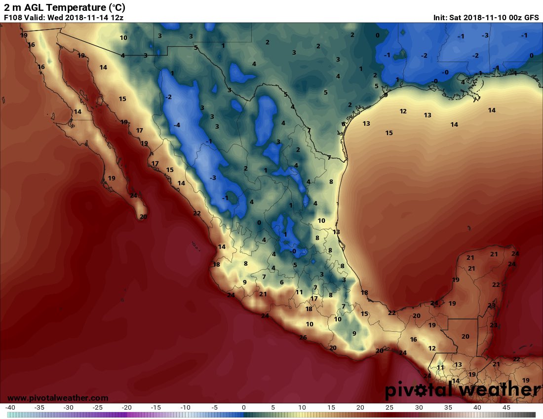
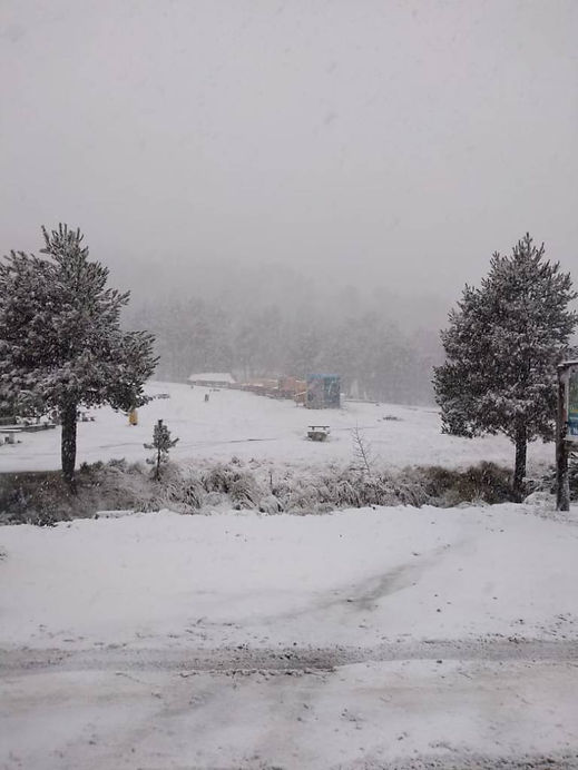
temperatures from 10 ° to-10 º C. ❄️ #Chih #Dgo #Coah #NL #Tamps #SLP #Gto #Qro #Hgo #EdoMex #CDMX #Pue #Ver 🌬 Violent "north" snowfalls of 110-140 km/h.

DrnQ6UPU8AAYTSQ.jpg


Translated from Spanish by Microsoft
🔶 CAUTION: It #TiempoInvernal will affect Mexico from next Monday, November 12th due to the inversion of Arctic air, causing #OndaGélida ❄️ Frost, snowfall, ice and very low temperatures over north, northeast, Central and eastern states.

Translated from Spanish by Microsoft
#MeteoredMX It is intense winter time since this weekend, strengthening next week. This is due to the "East Pacific Oscillation". Our meteorologist José Martín Cortés (@InfoMeteoro) explains:
Anteriormente, se habló de las oscilaciones del Atlántico Norte y Ártica, las cuales juegan un rol muy importante en los movimientos de masas de aire polar, así como sus trayectorias hacia latitudes menores como Estados Unidos y México durante el semestre relativo al invierno, es decir, octubre a marzo.

Previously, the North Atlantic and Arctic oscillations were discussed, which play a very important role in polar air mass movements, as well as their trajectories towards lower latitudes such as the United States and Mexico during the winter semester, that is, , October to March.

On this occasion another oscillation will be described, which significantly influences the entry of Arctic air and even, from Siberia, on the other side of the world, known as the Eastern Pacific Oscillation (EPO).

This pattern consists in the pressure difference between the Northeast Pacific, near Alaska, and the subtropical region of the Eastern Pacific in the vicinity with Hawaii, there being two phases.

Positive: Warm air flows in the direction of the west coast and over much of the United States. This configuration traps the polar cold far to the north, while over the central-western United States and southern Canada, temperatures dominate with values above normal.

Negative: When a warm anticyclone forms over the northeast Pacific and enters as a dorsal towards Alaska, it favors a very cold pattern over North America, causing a polar airflow that can cross from Siberia towards Canada, the United States and eventually, reach Mexico.
EPO

oscilacion-del-pacifico-este-y-su-influencia-en-invierno-en-mexico-21091-6.jpg

Valores en color azul, altura geopotencial (por debajo de lo normal) desde Canadá, cruzando Estados Unidos hasta México, indicando incursión de aire Ártico.

Specifically, what effects can it cause in Mexico?

Just the negative phase is what brings winter weather conditions to our country, and according to the forecast this could happen next week with an invasion of Arctic-Siberian air generating a drastic thermal decline in the country and violent "North" over the Gulf of Mexico.

In general, this oscillation can lower temperatures of 10-30 ° C below the climate, generating a cold to very cold environment, leading to the formation of frost. Commonly, the mass of air has a small amount of water vapor, so frost can be black (absence of moisture burns plants due to low temperatures) and thermal descent more drastically, since this type of air has the ability to cool down quickly

On the other hand, it is accompanied by a large rise or increase in atmospheric pressure that, when reaching the Gulf of Mexico, generates violent "North" events, whose intensities can easily exceed 100 km / h. If the cold mass is combined with moisture, it would result in extensive areas of snowfall as well as the formation of ice by fog (rime) and the presence of freezing or icy rain which is the precipitation of super-cooled liquid water that, when touched by a surface , it freezes quickly.

When the Arctic, North Atlantic, and Eastern Pacific oscillations enter the negative phase at the same time, the aforementioned effects may become even more severe and widespread over North America, including Mexico. In the next few days, we will be monitoring this possible "winter weather" favored by the negative phase of the "EPO" that would affect our national territory between Monday 12 and Thursday 15 November.

Stay tuned for updates on Meteored and take preventive measures.


Translated from Spanish by Microsoft
❄️ Important: #OndaGélida from 12-15/Nov will cause #TiempoInvernal in Mexico with cold atmosphere to very cold, snowfall, rain and "violent" North ⚠️ 
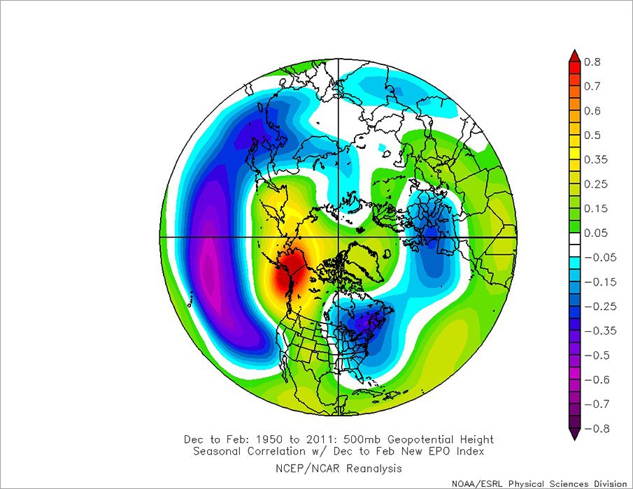
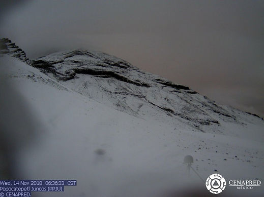
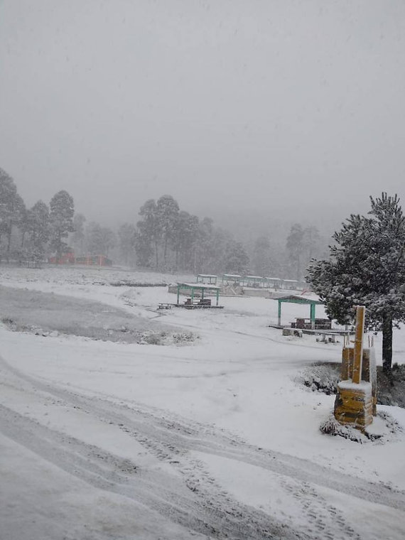
This situation is of risk for the population and animals, to carry out preventive measures. For details, follow the "thread"
 
Translated from French by Microsoft
The atmosphere will increasingly cool as of this #weekend, before a winter next week with a risk of #neige low altitude? L'atmosphère va se rafraichir de plus en plus à compter de ce week-end - - AGATE FRANCE

The Popocatepetl volcano and the Nevado de Toluca rise covered with snow; authorities urge the population to take extreme precautions.
https://www.safelivealert.com/single-post/2018/11/14/🌋-Volcán-Popocatépetl-y-Nevado-de-Toluca
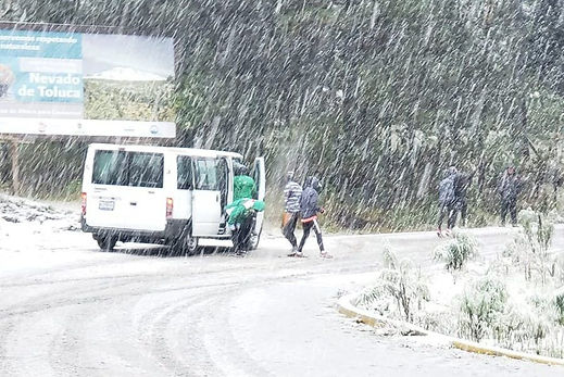
-🌋-amanecen-❄-cubiertos-de-nieve-☃
November 14, 2018
47a465_2da376ccfd43453788c18b781de1fd12~mv2.jpg


In an image broadcast by the National Center for Disaster Prevention (Cenapred) shows the Popocatepetl volcano at 06:55 a picture in which the colossus is covered in snow

47a465_c69490d64beb4ac789cc109165df3f80~mv2.jpg

However, in the most recent intense cloudy shots over the area prevent visibility towards the Popocatépetl.

Also, in the area of Nevado de Toluca, snow and sleet were recorded, as well as areas with fog and rain.

The Secretariat of Public Security of the State of Mexico asked the population to take extreme precautions when driving, especially in the area of the Nevado de Toluca, where snow falls this morning, as well as avoid climbing this volcano to prevent mishaps and cases of hypothermia.

47a465_daa9fcf3cd714588b9b3615f3b3ff723~mv2.jpg


The authorities urged the population to respect the speed limits and the traffic regulations, as well as driving with caution, since this morning they have increased the crashes, run over and road mishaps in areas such as Lomas Verdes, in Naucalpan; on the Mexico-Puebla highway, at kilometer 27, in Valle de Chalco, and in the Mexiquense Exterior Circuit, in the municipality of Ecatepec, which complicates vehicular traffic.

On his Twitter account @SS_Edomex, the Secretary of Public Security of the State of Mexico wrote: "#ExtremaPrecauciones when driving through the #NevadoDeToluca, #PoliticalStates guard the area as the slush continues, #PorTuSeguridad respects the speed limits and in case #Emergency approach the elements #CuidamosDeTi.

In another twee reported: "# C5 informs: According to the @conagua_clima, # Edomex is forecast cloudy sky, showers and snow or sleet probability in mountainous areas; with a maximum temperature of 15 to 17 degrees and minimum of 1 to 3 degrees Celsius Use 9-1-1, against any #Emergency.

He also broadcast several road accidents that were captured by the video surveillance cameras, in which he urges the population to prevent mishaps:
"#ExtremePrecauciones, the @SS_Edomex, through # C5 reports: Derived from the #Lluvias and through the cameras of videovigilancia, we see an #AccidenteVial in Lomas Verdes, first section, #Naucalpan. Public Security Unit, supports in the area, # Manages with Precaution.

Information released by the National Water Commission (Conagua) said that the weather is forecast for most of the territory of the State of Mexico cloudy with showers and rains in all municipalities, as well as snow and sleet fall in the high and mountainous areas , with maximum temperatures of 15 to 17 degrees, and minimum of 1 to 3 degrees Celsius for this day.

47a465_8c0792a88eb9477082fe796d575f5440~mv2.jpg

Translated from Spanish by Microsoft
❄️ Pines frozen by #Cencellada in beams #Veracruz with -2 º C. The rime is the formation of ice by fog, where the tiny drops of water present more temperatures of 0 º C or minor, are frozen when deposited on objects. Beautiful Winter #OndaGélida Panorama


5cfbbd6a89229a8e24c3c737c4001446.png

Massive snowfall causes deadly traffic pile-up & vehicle explosion in Russia's south -- Sott.net


11-14-18 Stuttgart, AR Shoppers Buy Cold Weather Necessities And Bundle Up In Snow
Published on Nov 14, 2018

 
In the post by Windmill knight on the previous page of the thread, there is a quote from the website electroverse.net. This page carries the slogan "DOCUMENTING EARTH CHANGES AS WE ENTER A GRAND SOLAR MINIMUM… " - well we know there is much else coming, but the information is useful. In the right margin one finds a collection of mirrored maps relating to ice coverage, global temperature anomalies, solar activity and space weather and galactic cosmic ray count all collected in one place. There is also a sub page with updates on extreme weather affecting crops, Crop Loss Archives - Electroverse

And one page has a forecast relating to the next few days, and with animated maps: "EUROPE BRACES FOR MONSTER NOVEMBER SNOW TOTALS" We don't know if it will get this bad, but at least one can test the forecasting accuracy.
 
Weather: Up to 6 cm snow, then things turn frigid
Updated: November 20, 2018 / Ottawa Canada
The forecast is staying snowy then get ready for the mercury to plunge deep into the double digits.

For Tuesday, expect a few flurries to end early in the afternoon after adding up to 2 cm, northwesterly winds at 20 km/h near noon and a high of -3 C.

The overnight snowfall left roads greasy and caused some traffic and school bus delays.


In the Outaouais, slippery road caused a school bus carrying a full complement of elementary schoolkids to slide into the ditch near l’Ange-Gardien. There were no injuries and the students were picked up by a backup bus.

Periods of light snow start overnight with winds of up to 15 km/h and a low of -8 C.

The snow, which is predicted to amount to 2-4 cm, winds up Wednesday afternoon then its cloudy skies with a 40 per cent chance of flurries. Northwesterly winds at 30 km/h gust to 50 near noon.

The high is -3 C but drops to -8 C in the afternoon and -17 C overnight under clear skies.

Thursday is sunny with a high of -7 C and low of -18 C.

Friday’s forecast features the start of a warming trend with sunny skies, a high of -3 C and a low of -10 C.

Saturday looks slushy with a high of 4 C and low of 0 C with a 40 per cent chance of flurries.

There’s a 60 per cent chance for flurries or showers for Sunday and 40 per cent overnight with a high of 5 C and low of 1 C.

Monday’s outlook is for a 40 per cent chance of flurries or rain and a high of 4 C.


norilsknews The weather today is not very. Be careful!
 
I wonder when the masses are going to wake up and figure it out? I think maybe many already suspect and that is what is behind the global insanity. But because the whole planet is factionalized, they can't get it together to do a darn thing.
 
On south hemisphere, people will have to forget the summer I guess.
Unseasonable Snowstorm Hits Falls Creek

An unseasonable snowstorm hit Falls Creek, Victoria, overnight, leaving the alpine resort in a blanket of fluffy snow on the morning of Thursday, November 22. A Falls Creek representative told Storyful it was abnormal to see heavy snow in November. “We do sometimes get January snow, however, this snowstorm has seen around 10 cm which is massive!” they said.
The ski season ended in early October, according to the Falls Creek website. Social media users were delighted to see footage of the snow. “Nearly a white Christmas in Australia! Wow now I’ve seen everything,” one Facebook user wrote. Snow was still falling in Falls Creek at time of writing

I also have a brother who lives in Australia and he also says that it will be almost summer, but the weather is still very cold and unpredictable with sudden temperature fluctuations for the season.
 
Short Range Forecast Discussion NWS Weather Prediction Center College Park MD
2:37 AM EST Thu Nov 22 2018
A deep upper-level trough over the West Coast will move inland to the Mississippi Valley by Saturday night. The system will produce rain and higher elevation snow over parts of the Pacific Northwest/California into Northern Intermountain Region/Great Basin on Thanksgiving.
The rain will end over Southern California by Thursday evening as the snow and lower elevation rain expands into parts the Northern/Central Rockies and continue over the region into Saturday. The rain will be heavy over Northern/Central California with heavy snow over the Cascades/Sierras, Northern Intermountain Region/Great Basin, and Northern/Central Rockies,
likewise, through Saturday.

11-22-18 04:00 Hrs. Donner Summit East Bound
 
Back
Top Bottom