Unprecedented Rainfall and Major Flooding Around the World

Floods kill scores in India’s tea-growing Assam; nine rhinos drown
2195346-1943628965.jpg

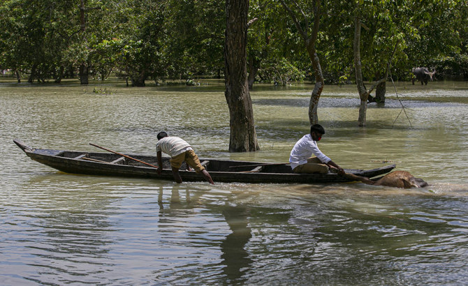
An Indian forest guard on a boat takes away the carcass of a wild buffalo calf through flood water at the Pobitora wildlife sanctuary in Pobitora, Morigaon district, Assam, India, Thursday, July 16, 2020. Floods and landslides triggered by heavy monsoon rains have killed dozens of people in this northeastern region. (AP)

GUWAHATI, India: Intense rain and floods in the Indian state of Assam have killed at least 84 people and displaced more than 2.75 million since May, authorities said on Monday, as they tried to collect the bodies of nine rare rhinos drowned in the past 10 days.
Rescue teams were facing a double challenge of rising flood waters amid the novel coronavirus as villagers driven from their homes huddle in shelters.

Officials warned that the water level in the Brahmaputra river was expected to rise by 11 cm (4.3 inches), two weeks after it burst its banks swamping more than 2,500 villages.

Assam, famous for its tea plantations, is hit by flooding every rainy season despite flood-control efforts.

Rights groups accuse corrupt officials of siphoning off funds meant for flood projects, resulting in shoddy construction of embankments which are often breached.

Floods have also inundated the Kaziranga National Park, home to the world’s largest concentration of one-horned rhinoceros, with an estimated 2,500 out of a total population of some 3,000 of the animals.

“Nine rhinos have drowned and over 100 other animals have been killed,” Atul Bora, Assam’s agriculture minister who is Kaziranga’s member of the state parliament stated.

With the park waist-deep in water, rhinos, elephants and deer have been forced to seek refuge on roads and in human settlements.
 
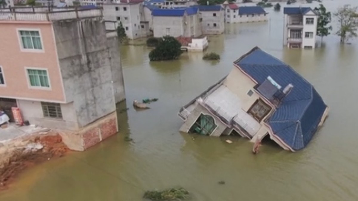
In China people experience the worst floods in decades. Torrential rains and rising river waters have swept across southern and central China. At least 140 people are dead or missing. Nearly 24 million people are affected.


Of course these floods are (partly) blamed on climate change (that's he plan anyway), but they could be (partly) induced by environmental modification techniques (ENMOD), which have been available to the US military for more than half a century. In these interesting articles, Professor Michel Chossudovsky explains his theory about this phenomenon.

'Weather-modification, according to US Air Force document AF 2025 Final Report,offers the war fighter a wide range of possible options to defeat or coerce an adversary”, capabilities, it says, extend to the triggering of floods, hurricanes, droughts and earthquakes:
‘Weather modification will become a part of domestic and international security and could be done unilaterally… It could have offensive and defensive applications and even be used for deterrence purposes. The ability to generate precipitation, fog and storms on earth or to modify space weather… and the production of artificial weather all are a part of an integrated set of [military] technologies.”


Weather patterns in North Korea, for instance, have been marked since the mid-1990s by a succession of droughts, followed by floods. The result has been the destruction of an entire agricultural system. In Cuba, the pattern is very similar to that observed in North Korea. (see Table 3). In Iraq, Iran and Syria, a devastating drought occurred in 1999. In Afghanistan, four years of drought in the years preceding the US led invasion in 2001, have led to the destruction of the peasant economy, leading to widespread famine.

While there is no proof that these weather occurrences are the result of climatic warfare, Phillips Geophysics Lab, which is a partner in the HAARP project provides a course for military personnel at the Hanscom Air Force Base in Maryland, on “Weather Modification Techniques”. The course outline explicitly contemplates the triggering of storms, hurricanes, etc. for military use.
(See his slide show at http://www.dtc.army.mil/tts/1997/proceed/abarnes/
Open PowerPoint presentation at http://www.dtc.army.mil/tts/tts97/abarnes.zip

While the US Force acknowledges that ENMOD weapons are part of the military arsenal, there is no formal proof or evidence that ENMOD techniques have been used by the US military against a foreign country or enemy of the US.


A forum search about ENMOD brought up this in the thread The coming "food shortage":
Agreed. I went and looked for that UN treaty of using weather as a weapon that lan Watt spoke of and found it.
It's been around since 1976 and was ratified in '78.
The Convention on the Prohibition of Military or Any Other Hostile Use of Environmental Modification Techniques (abbreviated ENMOD Convention) is a 1976 international treaty prohibiting the military or other hostile use of environmental modification techniques. It entered into force on October 5, 1978.

The C's have said that TPB technology is 150 years ahead of what we know is there and apparently they can have their satellites pinpoint tiny objects from space to induce heart attacks, so i would think it is entirely possible that nefarious entities engineer these types of weather that affect not only millions of people in a negative way but the geopolitical, economic and social structures as well resulting in misery, poverty, famine, disease and the likes.
 
About weather control....

I'm skeptical about that notion, but we have enough knowledge to make weather predictions far into the future, with climate modeling. And know where it will get rough.

And as governments like to take credit for everything, so that it feeds the perception of their power, and importance, conspiracies are hatched.

If we look at earth scale weather conditions, it would dispell the notion of intentional weather manipulation. We would see how the extremes are happening, and where the weather will get extreme based on geography.

That is known, but these notions rely on ignorance rather than science, but it is cloaked in scientific conjecture, and it is true we experiment on climate, but are too small to have the degree of control as is attributed to tptb. It's science fiction.

It is toying with the minds of the most ignorant, making an authority out of falseness, hiding behind a scientific premise.
 
KAMPONG KHLEANG, Cambodia - Crucial water flows to the Tonle Sap, Southeast Asia’s largest lake, have been delayed for a second consecutive year according to river experts, severely disrupting fishing and threatening the food supply of more than a million people.

Fishermen without fish as Cambodia's river reversal runs late


r

July 21, 2020 - The river reversal vital for Tonle Sap Lake may not happen until next month, officials said, owing to drought conditions and more than a dozen hydropower dams in China and Laos which are blamed for disrupting the natural flow of the Mekong River.

The Mekong typically swells in rainy season where it converges with Cambodia’s Tonle Sap River, causing an unusual reversed flow into the Tonle Sap Lake, filling it up and providing bountiful fish stocks.

But that hasn’t happened yet and people who depend on the lake are struggling to get by.

Water typically flows into the Tonle Sap lake for 120 days, swelling it six-fold before running back into the Mekong as the monsoon season ends, usually in late September.

Based on rain forecasts and rainfall data, the river’s unique reverse flow should happen in August, said Long Saravuth, a Deputy Secretary General of Cambodia’s National Mekong Committee.

The Mekong River Commission (MRC) attributes the delay to lower 2019 rainfall and operations of upstream Mekong hydropower dams, two of which are in Laos and 11 in China. “From now on, the reversed flow timing will likely not be the same as it used to be,” the MRC said.

Laos and China say the dams bring vital economic benefits and regulate water flow, helping to prevent severe floods and droughts. But fisherman San Savuth, 25, wants Cambodia’s government to negotiate the release of water from those dams to help Kampong Khleang’s 2,000 families.

Slideshow (3 Images)
Fishermen without fish as Cambodia's river reversal runs late
 
The largest death toll was recorded in the western province of Hodeidah, where 13 people died and more than 35 houses in three districts were destroyed.

Yemen flooding kills 14, washes away houses
2204011-661350597.jpg

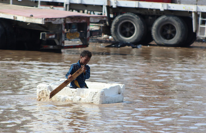
A Yemeni child plays in a flooded street in the southern city of Aden. (File/AFP)

July 26, 2020 - AL-MUKALLA: Heavy rains and flash flooding hit almost all Yemeni provinces in the last couple of days, killing at least 14 people and washing away dozens of houses, local media and local officials said on Sunday.

The largest death toll was recorded in the western province of Hodeidah, where 13 people died and more than 35 houses in three districts were destroyed.

Images on social media showed floods washing away houses, farms and cars in poor districts of Hodeidah. Flooding killed one person and ruined houses and farms in the province of Ibb, local media and residents said.

Heavy rains also hit the capital Sanaa, causing floods that affected many residential areas. “The damage in all affected areas is huge,” Salem Al-Khanbashi, Yemen’s deputy prime minister, told Arab News.

The flooding damaged power lines in the southern province of Lahj and wiped out farms in Hadramout and Abyan he said, adding that the National Emergency Committee had convened to discuss how to handle the damage and offer urgent assistance to the affected areas.

“The international donors and organizations should urgently help us. We cannot handle this problem on our own.”

On Saturday the country’s National Meteorological Center renewed its warning to the public to avoid flood courses and to avoid traveling this week, predicting a new wave of heavy rains, strong winds and flash floods in many provinces.

Last week a downpour that lasted for several hours ruined more than 90 houses in the historical city of Shibam, which is entirely made of mud, prompting residents and local officials into appealing for international help to rescue the city from collapse. Yemenis are also bracing themselves for further havoc in the form of a new locust invasion, as rainstorms create ideal breeding conditions.

Yemen has been embroiled in conflict since late 2014, when the Iran-backed Houthis seized control of Sanaa and expanded across the country. The fighting has created the world’s worst humanitarian crisis and devastated the national economy.

Despite the torrential floods, fighting raged on the main frontline across Yemen on Saturday and Sunday in the provinces of Hodeidah, Al-Bayda and Marib.

Yemen’s Defense Ministry said that army troops and allied tribesmen liberated a number of locations in Qania, in the central province of Al-Bayda.

Brig. Ahmed Al-Nageh, the commander of 117 Infantry Brigade in Al-Bayda, said government forces, backed by Saudi-led coalition warplanes, engaged in heavy fighting with the Houthis in Qania, adding that the warplanes targeted Houthi military personnel and equipment in Al-Sabel and Masouda mountains. Clashes were reported in Hodeida, where government forces pushed back Houthi incursions in Durihimi and Jah districts, local media reported.

Yemen is also battling the coronavirus pandemic, which has so far killed 474 people and infected 1,674 in government-controlled areas, according to the latest figures from the Aden-based National Coronavirus Committee.

Local and international health experts believe that the actual number of coronavirus patients is five times higher than the official figures.

Yemen Sees Return to Alarming Levels of Food Insecurity: UNICEF, WFP, FAO - World news - Tasnim News Agency
July, 25, 2020 - The Saudi-led war, floods, desert locusts, and now COVID-19 are creating a perfect storm that could reverse hard-earned food security gains in Yemen, warned the latest Integrated Food Security Phase Classification (IPC) analysis released recently by FAO, UNICEF, WFP, and partners.

The analysis carried out so far in 133 districts in southern Yemen forecasts an alarming increase of people facing high levels of acute food insecurity, i.e. in Crisis (IPC Phase 3) and Emergency (IPC Phase 4) by the end of the year, the official website of the UNICEF reported.

Acute food insecurity in these areas eased last year thanks to a massive scale-up of humanitarian assistance but all the good work could quickly be undone as the number of people facing high levels of acute food insecurity is forecast to increase from 2 million to 3.2 million in the next six months.
 
A study was released documenting land subsidence in California, one headline read something like 'California is sinking: Is it the 'New Atlantis', which is kind of apt. In the study they use satellite measurements and record how much of each area is moving - to the millimeter - with San Diego, Los Angeles, Santa Cruz and San Francisco identified as coastal hot spots suffering the most subsidence. Meanwhile, notably, inland Los Angeles "shows subsidence along small coastal zones, but most of the subsidence is occurring inland."

The study reminded me of some comments from the C's, which i've quoted below the study, these comments also remind us to not always take statements too literally, because as detailed in this thread, as well as in articles linked below, land movement of various kinds appears to be happening all over the planet, but all the same i thought it was worth noting.


The study:
California's sinking coastal hotspots revealed in new survey


Arizona State University
Phys.org
Fri, 31 Jul 2020 20:51 UTC


California sinking
© USGS NED
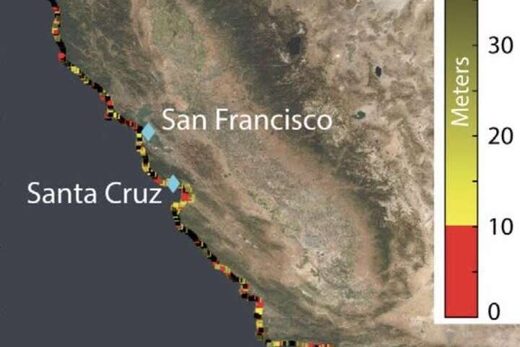
Coastal elevation in California. Coastal zones, which are defined to be those with elevations less than 10 m, are shown in red. Segments of the coast with elevations higher than 10 m are colored by a yellow gradient.
A majority of the world population lives on low lying lands near the sea, some of which are predicted to submerge by the end of the 21st century due to rising sea levels.

The most relevant quantity for assessing the impacts of sea-level change on these communities is the relative sea-level rise — the elevation change between the Earth's surface height and sea surface height. For an observer standing on the coastland, relative sea-level rise is the net change in the sea level, which also includes the rise and fall of the land beneath observer's feet.

Now, using precise measurements from state-of-the-art satellite-based interferometric synthetic aperture radar (InSAR) that can detect the land surface rise and fall with millimeter accuracy, an Arizona State University research team has, for the first time, tracked the entire California coast's vertical land motion.

They've identified local hotspots of the sinking coast, in the cities of San Diego, Los Angeles, Santa Cruz and San Francisco, with a combined population of 4 to 8 million people exposed to rapid land subsidence, who will be at a higher flooding risk during the decades ahead of projected sea-level rise.


Comment: The measurements show that the land is subsiding, but, as of yet, there is no evidence that sea level is rising, despite their biased 'projections'.

"We have ushered in a new era of coastal mapping at greater than 1,000 fold higher detail and resolution than ever before," said Manoochehr Shirzaei, who is the principal investigator of the NASA-funded project. "The unprecedented detail and submillimeter accuracy resolved in our vertical land motion dataset can transform the understanding of natural and anthropogenic changes in relative sea-level and associated hazards."

The results were published in this week's issue of Science Advances.

The research team included graduate student and lead author Em Blackwell, and faculty Manoochehr Shirzaei, Chandrakanta Ojha and Susanna Werth, all from the ASU School of Earth and Space Exploration (Werth has a dual appointment in the School of Geography and Urban Planning).

Em Blackwell had a keen interest in geology, and as Blackwell began graduate school, the applications of InSAR drew them to pursue this project. InSAR uses radar to measure the change in distance between the satellite and ground surface, producing highly accurate deformation maps of the Earth's surface at 10s m resolution over 100s km spatial extent.

Land subsidence can occur due to natural and anthropogenic processes or a combination of them. The natural processes comprise tectonics, glacial isostatic adjustment, sediment loading, and soil compaction. The anthropogenic causes include groundwater extraction and oil and gas production.

As of 2005, approximately 40 million people were exposed to a 1 in 100-year coastal flooding hazard, and by 2070 this number will grow more than threefold. The value of property exposed to flooding will increase to about 9% of the projected global Gross Domestic Product, with the U.S., Japan, and the Netherlands being the countries with the most exposure. These exposure estimates often rely only on projections of global average sea level rise and do not account for vertical land motion.


Comment:
Again this study is based on verifiable land measurements and yet the researchers insist on pushing an ideology backed by nothing.

The study measured the entire 1350-kilometer long coast of California from 2007-2018, compiling 1000s of satellite images over time, used for making a vertical land motion map with 35-million-pixel at ~80 m resolution, comprising a wide range of coastal uplift and subsidence rates. Coastal communities' policymakers and the general public can freely download the data (link in supplemental data).

The four metropolitan areas majorly affected in these areas included San Francisco, Monterey Bay, Los Angeles, and San Diego.

"The vast majority of the San Francisco Bay perimeter is undergoing subsidence with rates reaching 5.9 mm/year," said Blackwell. "Notably, the San Francisco International Airport is subsiding with rates faster than 2.0 mm/year. The Monterey Bay Area, including the city of Santa Cruz, is rapidly sinking without any zones of uplift. Rates of subsidence for this area reach 8.7 mm/year. The Los Angeles area shows subsidence along small coastal zones, but most of the subsidence is occurring inland."

Areas of land uplift included north of the San Francisco Bay Area (3 to 5 mm/year) and Central California (same rate).


Going forward in the decades ahead, the coastal population is expected to grow to over 1 billion people by 2050, due to coastward migration. The future flood risk that these communities will face is mainly controlled by the rate of relative sea-level rise, namely, the combination of sea-level rise and vertical land motion. It is vital to include land subsidence into regional projections that are used to identify areas of potential flooding for the urbanized coast.

Beyond the study, the ASU research team is hopeful that others in the scientific community can build on their results to measure and identify coastal hazards more broadly in the U.S. and around the world.
More information: "Tracking California's sinking coast from space: Implications for relative sea-level rise" Science Advances (2020). DOI: 10.1126/sciadv.aba4551 Journal information: Science Advances


Comment: See also:

The session quotes:

https://cassiopaea.org/forum/threads/arizona-burns.23712/post-263684 said:
16 July 1994 - the day Comet Shoemaker-Levy pieces began impacting Jupiter:

Q: (L) What are you here for tonight?
A: Prophecy.
Q: (L) What prophecies?
A: Tornadoes Florida - several.
Q: Where else?
A: Also Texas and Alabama.
Q: (L) When?
A: Sun is in Libra.
{...}
Q: (L) What else is going to happen?
A: Seattle buried; Japan buckles; Missouri shakes; California crumbles;
Arizona burns.
{...}


A: 99.9 per cent would not understand that concept. Most are always looking for literal translations of data. Analogy is novice who attends art gallery, looks at abstract painting and says "I don't get it."

Q: (L) Well, let's not denigrate literal translations or at least attempts to get things into literal terms. I like realistic art work. I am a realist in my art preferences. I want trees to look like trees and people to have only two arms and legs. Therefore, I also like some literalness in my prognostications.

A: Some is okay, but, beware or else "California falls into the ocean" will always be interpreted as California falling into the ocean.

Q: [General uproar] (F) Wait a minute, what was the question?
 
Southwestern mainland Mexico (and peninsulas), get an epic downpour.

Heavy rains / storms in Son, Sin, Nay, Jal, Col, Mich, Ags, Gto, Qro, Hgo, EdoMex, CDMX, Mor, Gro, Oax and Chis; Chih Mountains, Dgo, NL, Tamps, Ver, SLP.

The stream of Santiago in #Manzanillo , #Colima overflowed this afternoon due to the effects of the Tropical Storm #Hernan , an operation was activated to evacuate people who live in the vicinity.

Meteorología México @InfoMeteoro
8:51 PM · Aug 27, 2020
Important swell and constant heavy rains this Thursday in Manzanillo, Colima due to the proximity of the storm #Hernan . Video of
@Maurysev Accumulated 250-400 mm and waves of up to 5 meters are expected, favoring floods, flooding of rivers and landslides

State of emergency to be declared in Cihuatlán, Jalisco
Published on Friday, August 28, 2020
flooding.jpg

Four shelters have been opened for flood victims in Cihuatlán.

Faced with the flooding of homes and roads due to Tropical Storm Hernán, now downgraded to a tropical depression, municipal governments of Cihuatlán and La Huerta in Jalisco and Manzanillo in Colima have installed shelters to evacuate residents at risk.

In Cihuatlán, the municipal government opened four shelters to house evacuees, Mayor Fernando Martínez Guerrero announced, and was preparing to declare a state of emergency Friday morning as clean-up begins.

The El Pedregal arroyo in Melaque overflowed its banks, causing heavy flooding, as did the Río Purificación. A sinkhole partially closed the Santa Cruz-Melaque highway and in Emilio Zapata the Cuixmala River breached its banks leading to the closing of Highway 200 in both directions.

Mayor Martínez announced last night on social media that due to the volume of 911 emergency calls he was forced to set up a second telephone number for those needing immediate assistance.

In La Huerta, Hernán wreaked particular havoc in La Manzanilla where “half the town is practically flooded,” Mayor Ray Mendoza reported. “The rising stream collapsed the bridge that connects to the other side of the beach, which made a dam and this caused the water to rise to the center of La Manzanilla,” he said.

A mudslide blocked Highway 80 near the town of Lázaro Cárdenas, while in Mazatán water had risen to cover the bridge. Eight emergency shelters are currently operating and at least 185 people have been evacuated.

In Manzanillo, classrooms were welcoming evacuees and the mayor was considering opening a new shelter with a capacity of 300 if needed. Highways in the area have been closed due to landslides or flooding.

According to the National Water Commission, rains of more than 250 millimeters are expected in the two states as Hernán moves north. A storm surge of three to five meters is expected in coastal areas.

Hernán was moving at 33 kilometers per hour which should put it over the southern tip of the Baja California peninsula near La Paz later today or this evening. Maximum sustained winds were clocked at 55 kilometers per hour with some higher gusts. Hernán is expected to weaken to a low pressure area tonight and dissipate by Sunday.

 
500 mm en 24h dans l'arrière pays niçois, vallées dévastées par un épisode méditerranéen exceptionnel le 2 octobre
Numerous Tweets of the Devastation
500 mm in 24 hours in the hinterland of Nice, valleys devastated by an exceptional Mediterranean episode on October 2

October 2, 2020
A catastrophic Mediterranean episode hit the Alpes-Maritimes on October 2. Record rains were recorded in the hinterland. The balance sheet shows 8 missing.

Ahead of the cold front linked to storm Alex, Mediterranean upwelling affected the Var and the Alpes-Maritimes early in the morning of October 2. It is in the Alpes-Maritimes that the storms, torrential, were the most active.

Caught in a convergence, these thunderstorms dumped very large amounts of rain in the hinterland, flooding several tributaries of the Var River. The valleys of Tinée, Esteron, Roya and especially Vésubie were particularly affected.

In fact, it fell in these sectors between 200 and 350 mm of rain in only 12 hours and up to 500 mm in 24 hours in Saint-Martin-Vésubie. There is a large gradient between the coast and the hinterland.

In 6 hours, 218 mm of rain fell in Saint-Martin-Vésubie, which represents a new absolute record for the department (the old one was 194 mm in Cannes in October 2015). The 500 mm e 24h is also a new 24 hour record for the Alpes-Maritimes.

The electrical activity experienced a remarkable peak in the afternoon with nearly 1,100 lightning in 1 hour over the Alpes-Maritimes. In total, at the end of the day, the department recorded more than 5,500 flashes with more than 400 in the town of Tende, and more than 200 in Saint-Martin-Vésubie, Breil-sur-Roya and

Lightning strike density data show that the center of the department (first foothills of the Alps) was the most affected by thunderstorms. The Estéron, Roya, Tinée, Vésubie valleys are particularly affected with 20 to 50 flashes / 10 km². The most affected municipality being that of Ferres, near the gorges of Estéron.

En Suisse, le Tessin a été particulièrement concerné avec un cumul maximal de 421 mm relevés à Camedo. Il s'agit de la seconde plus forte valeur de précipitations en 24h en Suisse, le record étant de 455 mm sur la même commune le 26 août 1935. On peut aussi noter un cumul de 367 mm à Mosogno et de 275 mm à Bosco/Gurin :
 
The rain is light (at this moment), but persistent over the last 3 days..
Now this area will see more trees being uprooted due lose soil conditions, promoting aka widow-makers

The raging Vésubie: the impressive images of the ravages of the storm Alex


FLASH - A house turned upside down and swept away #Vesubie in the #AlpesMaritimes After the #TempeteAlex . The damage in the 3 valleys is colossal. 18 missing are wanted. (Le Figaro)#VigilanceRouge

The picture is of this morning, but now the precipitation has moved in.


Attachments

  • PA040766.JPG
    PA040766.JPG
    962.2 KB · Views: 5
Last edited:
About weather control....

I'm skeptical about that notion, but we have enough knowledge to make weather predictions far into the future, with climate modeling. And know where it will get rough.

And as governments like to take credit for everything, so that it feeds the perception of their power, and importance, conspiracies are hatched.

If we look at earth scale weather conditions, it would dispell the notion of intentional weather manipulation. We would see how the extremes are happening, and where the weather will get extreme based on geography.

That is known, but these notions rely on ignorance rather than science, but it is cloaked in scientific conjecture, and it is true we experiment on climate, but are too small to have the degree of control as is attributed to tptb. It's science fiction.

It is toying with the minds of the most ignorant, making an authority out of falseness, hiding behind a scientific premise.
I've heard over and over from a young age about frequent seasonal, sometimes deadly floods in China. Some of it has been from works of fiction (like The Good Earth, The Years of Rice and Salt), but first I heard it from stories of a great aunt that lived there for a long time as a missionary.
 
Global rain accumulation for the next 10 days


The Noah Syndrome (October 24, 2012)
by Knight-Jadczyk, Laura


The human cost of disasters: (Deep State Global Agenda)
In the period 2000 to 2019, there were 7,348 major recorded disaster events claiming 1.23 million lives, affecting 4.2 billion people (many on more than one occasion) resulting in approximately US$2.97 trillion in global economic losses.

This is a sharp increase over the previous twenty years. Between 1980 and 1999, 4,212 disasters were linked to natural hazards worldwide claiming approximately 1.19 million lives and affecting 3.25 billion people resulting in approximately US$1.63 trillion in economic losses.

Much of the difference is explained by a rise in climate-related disasters including extreme weather events: from 3,656 climate-related events (1980-1999) to 6,681 climate-related disasters in the period 2000-2019.

The last twenty years has seen the number of major floods more than double, from 1,389 to 3,254, while the incidence of storms grew from 1,457 to 2,034. Floods and storms were the most prevalent events.
 

State of emergency in Sanharo, Brazil after nearly 6 months' worth of rain in ONE day


The city of Sanharo in Pernambuco, Brazil, has declared a state of emergency after heavy rains caused major flooding in several areas of the city on Monday, November 2, 2020. According to the state's water and climate agency (APAC), 288.8 mm (11.4 inches) of rain was recorded in a 24 hour period, which was equivalent to almost half a year's average.

Meteorologists said the amount of rain is unusual for the month of November, which is commonly a dry month. Around 300 people were left homeless after floods triggered by heavy rains hit Sanharo. This prompted the city government to declare a state of emergency and accommodated the displaced victims at gymnasiums and schools.


More footage here:


USGS has issued a warning about the renewed movement at the Barry Arm glacier in Alaska that could lead to a 'massive, catastrophic landslide into the Harriman Fjord ' and trigger a 'mega-tsunami'. This is partly to due to the mass of material as well as the shape of the fjord itself.

In October NASA published an article warning of the above possibility because the glacier had begun to move for the first time since 2015.

The article and alert are posted below.

Notably they report that the slip began about 50 years ago but sped up between 2009 - 2015. And back in May of 2020 "a group of 14 scientists published an open letter warning that a landslide-generated tsunami is likely within 20 years and could happen at any time."

Throughout October they measured a movement of 8inches whilst between 2009-2015 it moved 600 feet.

As a reminder, on 17th October a strong magnitude 7.5 earthquake struck Alaska - now, whether that has had any effect on the movement, or it will, or whether it's indicative of what's going on around there, i don't know.


Landslide induced mega-tsunami 'could happen at anytime' at Alaska's Barry Glacier


barry glacier

Barry glacier June 2019
While kayaking in Barry Arm fjord in June 2019, Valisa Higman, an artist-in-residence at Alaska's Chugach National Forest, noticed some odd fractures on a cliff overlooking the fjord. Curious if the slope might be in the process of collapsing, she emailed photos (see one of them below) to her brother, Bretwood Higman. "Hig" is a geologist with Ground Truth Alaska, and he has studied landslides and tsunami deposits for decades.

He was soon inspecting the area using Google Maps, zooming in to the maximum extent possible and searching for signs of slippage. He saw the cracks as well, but nothing about them struck him as strong evidence of a big landslide. "But it turns out I had made a geology 101 error," he said. "I hadn't zoomed out enough, and I missed the big picture." Still, he kept Barry Arm on a list of possible landslides to investigate more someday.

A few months later, Chunli Dai offered that chance. The Ohio State researcher was working on a NASA-funded project to develop new ways to automatically detect landslides in the Arctic, and she was looking for test sites to check how well the tool was working. Her project makes use of a high-resolution dataset called ArcticDEM and machine learning to automatically search for and flag landslides.

When Dai used her tools to survey the Barry Arm area, she got some eye-popping results — an entire mountainside near Barry Glacier was slowly and subtly shifting. If the giant, slow-moving landslide were to suddenly collapse into the narrow fjord below, it would generate an extremely large tsunami because of the way the fjord's shape would amplify the wave.

"It was hard to believe the numbers at first," said Dai. "Based on the elevation of the deposit above the water, the volume of land that was slipping, and the angle of the slope, we calculated that a collapse would release sixteen times more debris and eleven times more energy than
Alaska's 1958 Lituya Bay landslide and mega-tsunami." That event, which was triggered by a 7.8 earthquake, dropped millions of cubic yards of rock about 2,000 feet (600 meters) into a fjord. It produced what is thought to be the tallest wave (1,700 feet) in modern history. In an event that eyewitnesses compared to an atomic bomb explosion, the huge wave washed away soil in a wide ring around the bay and obliterated millions of trees.

Barry Glacier

Barry Glacier September 15, 2013
Yet Higman and several of Dai's colleagues were initially skeptical that there actually was a slide in Barry Arm. The size of the landslide Dai was reporting was enormous — far bigger than any other known landslides in Alaska. Her detection technique was new and untested. And in some other areas, the presence of snow cover, shadows, or clouds caused the tool to erroneously label features in satellite images as landslides when they clearly were not.

But Dai kept looking and checking other types of satellite data, including a decades-long series of Landsat images of Barry Arm via Google Timelapse. When she scrutinized 2013 and 2016 satellite images of the area, it became abundantly clear that her ArcticDEM results were real.

"With the wider perspective from Landsat, the movement of the slope was impossible to miss," she said. "You can see a whole section of the mountain between Cascade Glacier and Barry Glacier slumping toward the water." (In the Landsat images at the top of this page, use the slider to see the movement for yourself.) The slope moved forward by about 400 feet (120 meters) between 2010 and 2017. Since 2017, it has moved very little.

[You can find the slider imagery here.]

Immediately after seeing the Landsat images, Higman was also convinced something serious was happening and alarmed about what it could mean. Since then, he has been reaching out to colleagues and coordinating with state and federal partners to evaluate the risk. In May 2020, a group of 14 scientists published an open letter warning that a landslide-generated tsunami is likely within 20 years and could happen at any time. If a landslide occurs, the resulting tsunami in BarNASA Earth Observatory images by Lauren Dauphin, using Landsat data from the U.S. Geological Survey. Story by .ry Arm could produce waves that are hundreds of feet high. Other, more distant bays — such as the more heavily populated Passage Canal (about 30 miles/50 kilometers away) — could see 30-foot (9-meter) waves.

By looking back at older satellite images and aerial photographs, the team of scientists has determined that slippage in this area is nothing new. They think the slope began to shift at least 50 years ago, but it appears to have sped up between 2009 and 2015, just as the front of Barry Arm glacier was retreating. "The slope probably sped up because the glacier that had been supporting the bottom of the slope retreated," explained Higman. "When warming temperatures caused that ice to retreat, the slope was free to move."

The open letter prompted new monitoring projects at the U.S. Geological Survey, the Alaska Department of Natural Resources, and the National Atmospheric and Oceanic Administration. Researchers are now working to track the slope's motion with synthetic aperture radar on satellites, aerial lidar, and aerial photography. Other scientists are setting up gauges to detect tsunami waves in advance. And others are working to make better maps of the bathymetry (shape of the seafloor) of the fjord to more accurately model how a tsunami might move through it.

"We have learned a tremendous amount about this hazard, and I think we have done a good job of getting the word out about it," said Higman. "But there are still a lot of really interesting and important scientific questions that we are only barely starting to investigate." For instance, why did the landslide stop slipping in 2017 and does that mean it is less likely to collapse in the short term? Also: can we expect to see a sharp increase in this type of hazard as more and more glaciers retreat?

"These are fairly unusual events, and scientists have only started studying the connections between glacial retreat and landslide tsunamis in the past few decades," he said. "We don't have a very long or deep record to look at yet."

USGS alert:

For Immediate Release: November 10, 2020

Satellite imageryshows renewed movement of Barry Arm landslide(Anchorage, AK) – New satellite imagery has shown renewed movement of a large landslide along the Barry Arm of the Prince William Sound 28 miles northeast of Whittier, Alaska.

The U.S. Geological Survey measured 8 inches of downslope creep between October 9 and October 24. It is the first detected movement of the landslide since active monitoring began May 26, and was achieved by comparing earlier Interferometric synthetic aperture radar (InSAR) satellite imagery with more recent satellite data. While the National Tsunami Warning Center has no current indication a catastrophic landslide failure and tsunami are imminent, landslides are unpredictable. Communities throughout Prince William Sound need to remain vigilant, and mariners should strongly consider avoiding areas near Barry Arm and Harriman Fjord. For more information on tsunami warning and response, go to the National Tsunami Warning Center. Retreat of the Barry Glacier has removed support for the hillside, which slid 600 feet downslope between 2009 and 2015. Geologists and geophysicists are concerned a massive, catastrophic landslide into the Harriman Fjord could trigger a tsunami that would threaten local communities. An interagency science team comprised of state, federal and other scientists has been monitoring the situation.

“We ask that everyone continue to avoid this part of Prince William Sound,” said Alaska’s Division of Geological and Geophysical Surveys Director Steve Masterman. “We take this threat seriously and encourage those in the Sound to have a plan in case of tsunami.”

State and federal agencies continue to monitor the situation and will keep the public informed about ongoing efforts and important updates.Current information is available at the Barry Arm Landslide and Tsunami Hazard
 
Last edited:
Guillaume Séchet
Heavy rains hit the #Guadeloupe . Basse-Terre was the most affected with local accumulations of up to nearly 200 mm in 24 hours! (via
@MeteoFrance_AG ) 7:34 AM · Nov 11, 2020· France

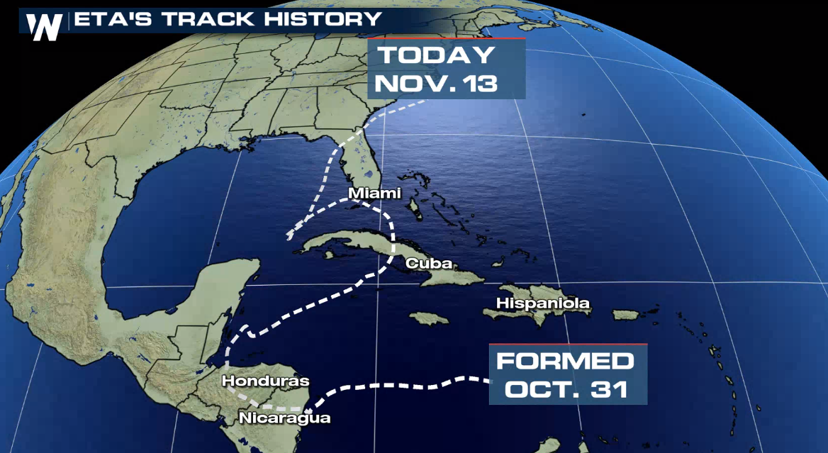
New alerts have been issued for Florida’s Gulf side where tropical storm warnings and a storm surge watch are now in effect as Eta will affect the area by Thursday.

The latest intensity forecast now has Eta remaining at Tropical Storm strength through the week as it moves through the eastern Gulf of Mexico and now makes another landfall north of Tampa and eventually tracking over Gainesville in Northern Florida by the weekend.

With the Security Cabinet and the state governor, we are addressing the problem caused by the floods and supporting the victims of Tabasco.

.@Agricultura_mex He remarked that “the relationship of damages to crops, livestock and productive infrastructure will be announced once the corresponding evaluation is made, which is carried out, in the case of floods, after the water drops

Last week the three Central American countries suffered the onslaught of Eta, which struck Nicaragua as a category 4 hurricane and left more than 200 dead and millions of dollars in damage to homes, roads and crops.

 
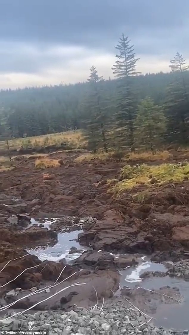
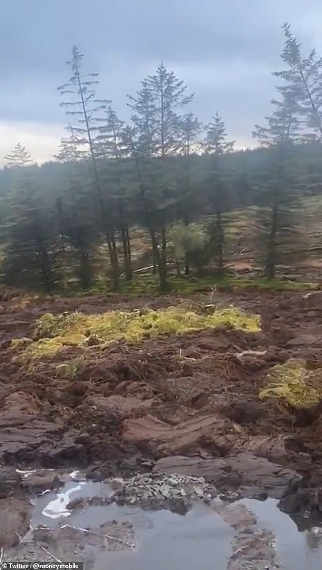
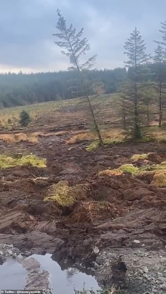
Peat landslide/landslip caught on video at a windfarm in Donegal, northern Ireland, and below is an article about the incident by the Daily mail.

It seems to be a rare occurrence with a local Councillor stating he wants to know how it happened.

It seems possible that both Earth Changes and wind turbines, that are destructive at the best of times, could've combined and caused this to happen.

It's around the 30 second mark that it becomes clear what's happening. Quite an odd sight with the trees just casually sliding by.


Amazing moment trees on hillside slide down slope after peat slippage on windfarm in Northern Ireland​

  • A passerby was stunned to see an entire landscape move in front of his eyes
  • The unsettling incident was the result of a peat slippage in Northern Ireland
  • There were no reports of injury or concerns the local water supply affected
Published: 17:23 GMT, 15 November 2020 | Updated: 17:23 GMT, 15 November 2020


This is the startling moment an entire landscape moves from one side of a hill to another during a peat slippage in Northern Ireland.

The unsettling incident was witnessed by a surprised passerby and caught on camera, as a number of mature trees rapidly glided down a slope at Meenbog Wind Farm, just south of Ballybofey, on Friday afternoon, according to Buzz.

While there were no reports of injury or concerns that the local water supply could be affected, one councillor said 'there are serious questions about how this happened.'

Scroll down for video
A passerby caught on camera the moment a landscape of trees seemed to move towards him


A passerby caught on camera the moment a landscape of trees seemed to move towards him
The unsettling incident was the result of a peat slippage on a farm in northern Ireland


The unsettling incident was the result of a peat slippage on a farm in northern Ireland
An investigation has now been launched into how the incident occurred in the first place


Councillor Gary Doherty of Donegal County Council said: 'I've this morning requested an immediate stop on all works at the site until a full investigation is carried out and the full extent of the damage caused is known.'


Authorities including Donegal County Council and The Loughs Agency have launched an investigation into how the incident occurred and the extent of the damage caused.
 

Trending content

Back
Top Bottom