Volcanoes Erupting All Over

Update:

VIDEO: Scientist Describes Eruption Changes On East Rift, At Summit
on Jun 6, 2018 at 7:27 am / 11:20

Big Island Video News Published on Jun 5, 2018

'It's saddening': Massive river of lava wipes out hundreds of homes
PAHOA, HAWAII (HawaiiNewsNow) - Two Video's / 06:10 / 08:10
Snips: Economic, Sea-life effected
Just a few days ago, before a river of lava forged a path through Kapoho, this neighborhood on the Big Island was a picturesque vacation destination for many. Now, the area is almost completely inundated after a slow-moving flow pushed its way through, claiming hundreds of homes in what was considered to be the most destructive day of any eruption in modern times.

Skipping Down

On Wednesday, USGS officials said lava has also spread over all of Vacationland to the south, and is pouring into the ocean nearby. To the north, lava has covered all but a small portion of Kapoho Beach Lots.
The lava not only took homes overnight from Tuesday to Wednesday, but it completely filled Kapoho Bay, extending 0.8 miles from the coastline.

On Tuesday, the governor issued a second supplemental emergency proclamation, with rules to help shelters, law enforcement and disaster response.

The destruction wrought in a matter of days in the area eclipses the number of homes destroyed in the Leilani Estates and Lanipuna Gardens subdivisions, where the eruptions first started more than a month ago.

Officials haven't yet released the total number of homes destroyed in Kapoho. But the assessment that "hundreds" more had been claimed by lava comes just a day after the official figure was put at 159.

Talmadge Magno, Hawaii County Civil Defense administrator, said there were at least 350 homes at Kapoho Beach Lots and 140 in Vacationland. Most of those homes are believed to have been lost.

SD

Seismic activity, meanwhile, remains very active at Kilauea.

On Tuesday morning, a 5.6-magnitude quake struck near the summit. And on Sunday afternoon, 5.5-magnitude quake centered near Kilauea's summit rocked the Big Island. No tsunamis were generated by either earthquake.
Since May 4, some 9,900 quakes have rattled Hawaii Island, the USGS said.

8237e0a7cb89df1f8b37789746bbbcc7.png


I for one, don't blame him one bit!
 
Adapt 2030 Published on Jun 7, 2018
It is almost unthinkable that the media is not reporting on the interconnections of the massive uptick in Earth changes awe are seeing at the moment. Snows in June in seven countries in the Northern Hemisphere, the relationship between increasing galactic cosmic rays and volcanic eruptions and how this in-turn effects our crops globally. They don't want to talk about crop losses or the connecting to next year being more unusual than this year with heavier losses on tap in 2019. This is a full explanation how it all intersects and a forecast going out to 2021.

Big Island Video News Published on Jun 8, 2018


The Latest: Kilauea Eruption Update
Updated: Jun 08, 2018 9:19 PM RDT Two Vids- 04:20 / 03:45
Snips:
9:18 a.m.
National Weather Service reports high levels of vog and sulfur dioxide from the fissure system are moving north and wedging in the Saddle area, creating poor visibility on the roads. Drive with caution. The Big Island interior and south are expected to have increased levels of vog until tonight.

Due to volcanic emissions and changing wind conditions, the following guidance is given
  • The Department of Health recommends limiting outside activities and stay indoors if you have breathing issue
  • Stay alert and be ready to leave the area should conditions change.
  • N-95 masks that were distributed are for ash or vog particulate and will NOT protect from gasses or vapors, including SO2.
  • You can monitor sulfur dioxide and hydrogen sulfide on Hawaii Island by visiting the Civil Defense website
June 8, 8:40 a.m.
A 5.2 mag earthquake was reported just after 3 a.m. Friday. No tsunami threat to the state.

Fissure 8 is producing a large channelized flow that is entering the ocean at Kapoho Bay and producing a large laze plume.

Hawaiian Volcano Observatory also reports that a steam explosion occurred at the Kilauea Summit early this morning, so be aware of ash fallout if your commute takes you through Ka’u

3:48 p.m.
The county confirms more than 600 homes have been destroyed.
The state is slated to give the county $12 million to continue the response.
Fountaining at fissure 8 has reached between 190 and 250 feet in the air.
Ocean entry into Kapoho Bay is 1.2 miles wide.

3:40 p.m.
"Vacationland is totally gone, it's covered by lava, Kapoho Beach Lots, the northern section is still intact but the rest of it is under lava" said Talmage Magno, Hawaii County Civil Defense Director.
16690559_G.jpg

Hawaii County Civil Defense says official count of homes destroyed remains at 130 but that amount does not include any of the homes in Kapoho or Vacationland. There are an estimated 350 homes in Kapoho and 150 in Vacationland. The county is waiting on an official report before releasing an updated number of homes destroyed due to the Leilani Estates Eruption.

Earth in upheaval: Hawaii has been hit by over 12,000 earthquakes during last 30 days -- Sott.net
Michael Snyder The American Dream Wed, 06 Jun 2018 00:00 UTC
 
Thanks c.a. for the update.

To hear the mayors words is a tought one for him to deliver, yet he is stating the realities and challenges ahead. At one point he said, I don't know what to tell you.

 
Edge of Wonder Published on Jun 8, 2018 / 9:17
Links within:
We thought the Kilauea volcano in Hawaii was simply a natural eruption caused by earthquakes, however, Dr. Michael Salla paints a whole new picture that is darker and for more sinister on what he believes is the actual cause of the eruption.

Join Ben and Rob as they sit down with Dr. Michael Salla at Contact In The Desert about the causes of the Kilauea volcano and the ramifications of what could happen if something is not done about it. What are your thoughts? Like, comment and subscribe for more update and guest speakers at CITD 2018!

*Dr. Michael Salla is an internationally recognized scholar in international politics, conflict resolution and US foreign policy, and is the author/editor of an additional four books. He has a Ph.D in Government from the University of Queensland, Australia, and an M.A. in Philosophy from the University of Melbourne, Australia. He has conducted research and fieldwork in the ethnic conflicts in East Timor, Kosovo, Macedonia, and Sri Lanka, and organized peacemaking initiatives involving mid to high level participants from these conflicts.

Evidence Grows that Hawaii Volcanic Eruption Caused by Puna Geothermal Venture
on May 27, 2018.
The surge in volcanic activity in the lower Puna region of the Big Island of Hawaii is concentrated in the area surrounding the Puna Geothermal Venture. Scientific data clearly links the unacknowledged fracking activity at the Puna Geothermal Venture as a factor in what is occurring with lava flows and earthquakes.

More scientific data shows how the fracking may have been deliberately designed to create a geological process by which lava would drain from Kilauea’s summit into the East Rift Zone so as to create large new vents that would destabilize the geology, and possibly trigger a major collapse in the Hilina Fault System.

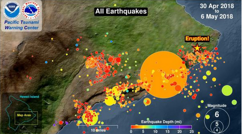
A video prepared by Pacific Tsunamic Warning Center clearly shows that the epicenter of earthquake activity centered in the lower Puna region is adjacent to the Puna Geothermal Venture.


The following map from the video depicts all the earthquakes and the eruption site for the recent lava outbreak from 30 April to 6 May. The eruption occurs mainly in Leilani Estates, which is right next to the Puna Geothermal Venture

bfaeee427b7a00a4215bf34b26d9fabd.png


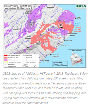
The following map by the US Geological Service shows where the Puna Geothermal Venture (marked PGV) is in relation to the current volcanic eruption.

cceb358a422fa437cd703b906bf917b8.png

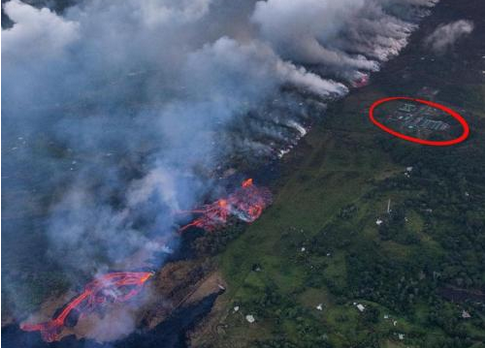
Here’s a photo showing the lava outbreak and its very close proximity to the Puna Geothermal Venture (circled in red) on May 22. Since then, it has begun flowing onto the property, but still not reached any of the wells.

250715a35203959ab04c7c28b2f8384b.png

The scientific data clearly shows how the Puna Geothermal Venture (PGV) is at the epicenter of the volcanic eruption. Is this merely chance or by design?

In my 
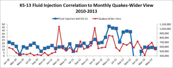
previous article and video published on May 15, I wrote about how the fracking activity at PGV has been scientifically linked to earthquakes. The following diagram was included which clearly showed the strong correlation:
PGV-Quake-Inj-Correlation-KS-13.jpg

Source of earthquake data: Advanced National Siesmic System – ANSS, Source of Injection Data is the EPA

Since the publication of my article, there have been other articles linking the fracking at PGV with earthquakes, and also raising the question of whether the fracking caused the volcanic eruption. The most prominent one has come from Jon Rappoport, who wrote a May 22 article on his blogsite titled: “Did fracking cause the Hawaii volcano eruption?”

In my May 15 article and 
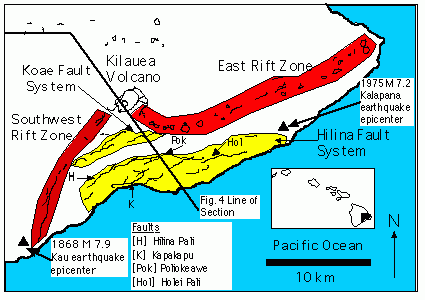
video, I mentioned the Hilina Slump and how it may have been related to the fracking occurring at PGV. This has led to much criticism in the video’s comments section, but the scientific facts do show that earthquake activity is related to movements in the Hilina Fault System. Here’s a map showing the Hilina Fault System in relation to the East Rift Zone.

Hilina-Fault-System.gif

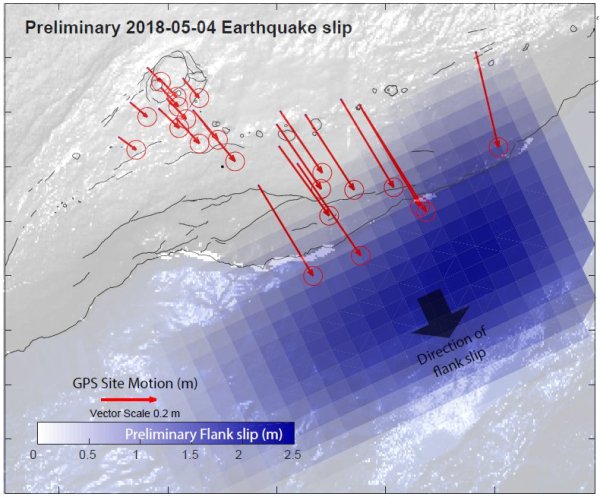
The following map produced by the Hawaii Volcano Observatory shows how the recent earthquake activity led to the Hilina Slump slipping towards the Pacific Ocean Observatory by about two meters, which is massive in geological terms.
Hilina-Slump-movement.jpg

Source: Berkeley Seismology Lab

Here’s how an article produced by the Berkeley Seismology Lab explained the above photo:

While the earthquakes under the summit and under the eruption center at the eastern end of the rift zone are generated by the movement of magma, the big event and its aftershocks under the pali have a different origin. This becomes obvious in Figure 2 [reproduced above]. It shows how the permanent GPS stations installed and operated by the Hawaii Volcano Observatory moved in response to the 6.9 quake. The red arrows indicate the direction of horizontal motion and all of them point to the southeast. The length of each arrow represents the extent of the motion with the longest ones having moved by more than 2 feet. This shows that the flank of the cliff on the southern coast of Hawaii has moved further towards the ocean.

What the article didn’t mention was that the 6.9 quake on May 4 was triggered by the massive outflow of lava from Kilauea Summit, Halemaʻumaʻu crater, into the East Rift Zone. Basically, the volcanic eruption in the Lower Puna region (where the Puna Geothermal Venture is located) is being fueled by fresh lava from the summit of Kileaua, which is being drained towards it.

While it began slowly as old lava oozed out of the new volcanic fissures in Leilani Estates, the recent upsurge is a result of fresh new lava arriving from the Kilauea Summit. The Honolulu Advertiser explained the process:

The first weeks of the eruption saw pasty, crumbly, slower-moving aa lava oozing slowly through the fissures. But that changed Friday afternoon, scientists said, when preliminary results from a testing sample showed a different composite of lava, the smoother pahoehoe variety that is generally fresher, hotter and faster.

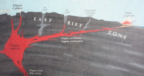
The following diagram shows the dynamics of the lava flows linking Kilauea Summit, the Pu’u’O’o Vent, and the East Rift Zone.


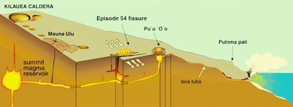
Source: Ars Technica


An article by Scott Johnson in Ars Technica, explained the process as follows:

Kīlauea’s main magma chamber seems to be a few kilometers below Halemaʻumaʻu Crater at its summit. When the volcano’s guts gurgle with a new injection of magma from below, the lava lake in Halemaʻumaʻu Crater rises. The conduits and crevices that constitute Kīlauea’s “plumbing” extend from the summit region over to the East Rift Zone. So after lava rises in Halemaʻumaʻu Crater, the lake sometimes drains back down as the new magma moves on toward the eastern section of the volcano.

This is where we finally get to the issue of whether the fracking at Puna Geothermal Venture was secretly an attempt to weaken the underlying geology in order to create a path for fresh lava to drain from Kilauea summit into the East Rift Zone. As the following diagram of the East Rift Zone illustrates, lava follows the path of least resistance in a highly pressurized environment.

c963be4f8d0ccf6d0ead0d0454e64fd9.png

This principle would be well known to any geologist, or plumber if we use Johnson’s analogy. This means that some would have been aware from the inception of the PGV in 1993, that the process of using highly pressurized water on subterranean rocks (aka fracking), severely compromising the underground environment, would effectively open up a new path for lava to flow from the Kilauea summit and the Pu’u’O’o Vent

Apparently, this is exactly what was planned by those behind the Puna Geothermal Venture according to Paul Collin, who has strong ties to the U.S. intelligence community:

It is understood that Hawaii’s geothermal power company “Puna Geothermal Venture” (PGV) purposefully “drilled” wells and “fracked” into the ground in such a way that lava from Earth’s mantle would eventually be redirected to open-up and spout a ‘brand new volcano within the island of Hawaii, and sure enough facts set forth by a USGS chart and briefing that lava has now been routed right along the same linear path south-east, which actually punched-out a ‘brand new caldera volcano’ within the “Lower East Rift Zone” adjacent to the extremely weak debris landmass known as the ‘Hilani Slump’ consisting of 10% of Hawaii’s southeastern land mass that was already slipping into the Pacific Ocean ‘without the new lava delta’ growing huger; about 400 meters per hour on land (alone) – threatening a tsunami event from coast to coast.

In my May 15 article, I described how the creation of a massive tsunami through a collapse of the Hilina slump was the secret purpose behind the creation of the Puna Geothermal Venture, whose owners are linked to the Rothschild family.

I wish to state for the record that I don’t believe the plan will succeed, and that the hoped-for megatsunami that would cripple the United States economically and militarily for decades to come will not occur. However, it is vitally important to expose this plan was and who is behind it.

My view is that the Rothschild family has chosen China as the hub for the kind of New World Order that the Deep State/global elite would like to emerge. That would be an openly authoritarian state where AI technology is used to monitor citizens and quickly remove troublemakers expressing dissenting political views.

The United States is the main obstacle to such an authoritarian New World Order being created, and secret geo-engineering was therefore undertaken in Hawaii that would create a megatsunami via a major collapse of the Hilina fault system.


If the plan had worked, then it is not hard to see how the U.S. would have been unable to prevent a New World Order emerging – based on China’s authoritarian socio-political model masked behind AI technology designed to appeal to a tech savvy Millennial generation.

It is also important to mention that this is the second time in 2018 that Hawaii was targeted by the Deep State/global elites for some kind of catastrophic event that would economically and militarily weaken the United States. On January 13, 2018, a ballistic nuclear missile was sent by a secret CIA linked Navy, called the “Dark Fleet”, in a false flag attack that was meant to embroil the United States in a catastrophic nuclear war.

In a January 20 article, I provided documents and references showing how the CIA has built its own secret fleet that conducts covert operations on behalf of the Deep State/global elite. Thankfully, that plan failed due to the intervention of a U.S. Air Force based secret space program that shot down the missile, as I discussed another article.

Since 2004, I have lived on Hawaii’s Big Island. On May 1, 2018, I moved from the lower Puna region just as the earthquakes intensified, to the Kona side of the Big Island. It boggles the mind that such a beautiful part of our planet is being repeatedly targeted by the global elite for catastrophes that will facilitate their New World Order plans.

I sincerely hope that appropriate legal and political action is taken against: all those behind the Puna Geothermal Venture for their role in the devastation that is being caused in the lower Puna region by their secret fracking; the local County officials that were likely bribed to remain silent over the risk of permitting such a venture; and also against the global elites who put together such a nefarious plan.

© Michael E. Salla, Ph.D. Copyright Notice

[Note: Audio Version of above article is available here or can be viewed below]

For further information on Michael E. Salla, Ph.D. Check: Sott Talk Radio Show!
The Truth Perspective: UFO Secrecy and JFK with Dr. Michael Salla

29 May 2015 (USA)
 
Last edited:
For me, Michael Salla has about O credibility after promoting Corey Goode. So l wonder what he’s up to with this story. Others have spoken about the possibility, that the PGV has contributed to this major eruption with good reason, so I’m not dismissing the possibility only that Salla is a suspicious character in my book.
 
Last edited:
Big Island Video News Published on Jun 10, 2018 / 1:48

USGS Scientist Shares Kilauea Eruption Update (Jun. 11, 2018)
[SIZE=4]https://www.youtube.com/watch?v=HgyeViAtN0A[/SIZE]
Video / 7:59 Up welling of water @ 2:31
ca2e06091eb7e7177afd0efecac00b5b.png

Comments:
Upcycle Electronics 57 minutes ago
Can someone go grab a couple undergrads to seed into these question groups? I swear, the bar has been set extremely low here. I've watched every one of these for weeks.

This is pathetic. Not a single person from any media outlet and asking questions has spent 15 minutes researching volcanism. The most intellectual question has been 'do you think this parallels the 1924 eruption?' That was several weeks ago. Com'on people!

They've stated that there was potential for a major steam explosion event like 1924 back when the lava lake first subsided. Then a few days later this guy showed up and said they were revising the whole steam event hypothesis. Here he said it was a steam explosion. What's that all about. He's also mentioned that they felt Kilauea should be reclassified as an explosive volcano.

So the intelligent questions would be, what other parallel events and volcanos is USGS drawing parallels to at this point, or how does the current influx of data help you to revise your understanding of Kilauea? I swear there are more than a few imbeciles at these things acting like a scientist is a weather man there to predict the future. Science is observation and recording of information. By asking a scientist about anything unrelated to observations and recorded information proves your a total idiot.

Ask him/them about the SCIENTIFIC facts that allow the rest of us to draw our own conclusions about the future implications. Quit trying to show off a 2 digit IQ. If this is the best these reporters can do, get some new people. This is just pathetic and pointless both for this guy's time and for those of us in the intellectual minority. -Jake
http://icecream.me/uploads/39c102db2d0a4f5a1ca4fd05c29a6522.png

Big Island Video News Published on Jun 11, 2018 / 23:06

https://twitter.com/BigIslandNow/status/1006433078246424576
476301ef8238d1df5b99ab951f0de84a.png


Exclusive Interview With Mayor Kim: / 20:38
http://bigislandnow.com/2018/06/11/exclusive-interview-with-mayor-kim/?t=1528749280
Big Island Now Meteorologist Malika Dudley interviewed Hawai‘i Island Mayor Harry Kim in the Emergency Operating Center in Pāhoa on Monday morning, June 11, 2018.

In the interview, the mayor disclosed that approximately 410 people are currently in the two available shelters and at least 600 to 700 homes have been destroyed by lava, although officials are working on determining the exact number lost.

“I would be very surprised if it were less than 700,” the mayor said. “I would not be surprised if it was over 700,” the mayor added, considering the number of un-permitted structures in the area.

https://twitter.com/KHONnews/status/1006431900758523904
Hawaiian Airlines changes Big Island flight schedule
Reporter, Pacific Business News 7 hours ago

White House announces President Trump to visit Hawaii after historic North Korea summit
Updated: Jun 11, 2018 06:10 AM HST Video / 00:44
HONOLULU (KHON2)
- The White House says President Trump plans to visit U.S. military bases in Guam and Hawaii on the return from his historic summit with North Korea's Kim Jong Un.

The White House says Trump will stop at Andersen Air Force Base in Guam on Tuesday and also travel to Joint Base Pearl Harbor-Hickam in Hawaii later in the day.

This story is developing, stay with KHON2 on-air and online for the latest details.

https://twitter.com/Astro_Feustel/status/1005918062166577154
We can still see the Earth’s fury from @Space_Station as the lava continues to flow from #Kilauea. Expedition 56 is thinking of Hawaii as the dynamic Earth continues to evolve. 2:02 PM - 10 Jun 2018
DfW9I9RVQAAkFEa.jpg


Adapt 2030 Published on Jun 11, 2018 / 6:10
A freeze warning was put out on the Big Island of Hawaii that was above 12,000 ft. Rare is what the meteorologists said. This is termed ice nucleation, the other famous volcanoes were Pinatubo and Iceland that grounded air traffic across Europe. So we need to ask ourselves, how big is this eruption now? Snow across Idaho and Montana and some Rocky mountain states, freezing low temperature for N.E US.
 
Last edited:
(BIVN)
Like hundreds of his neighbors in Kapoho, Martin Blackwell just lost his home to lava. Yet the man who teaches calming techniques in times of fear and uncertainty has not changed his outlook.

We first met Blackwell in October 2014. At the time, a lava flow from Pu’u O’o had made its way miles downslope, and was threatening to inundate the town of Pahoa. Blackwell – who says he is a trauma, grief, and crisis therapist with experience in licensed clinics – was busy providing comfort and assurance to folks who were on the verge of panic. “Breathe slow… with the flow,” Blackwell’s business card reads. “Let excess fear and tension go.”

The lava flow stopped short of covering the village. Now, over three and a half years later, a new eruption has had far more destructive impacts on Puna. After devastating Leilani Estates with a line of volcanic fissures, a large lava flow channeled down to Kapoho and wiped hundreds of homes off the map, Blackwell’s home included. He watched it burn in a video released by Hawaii County Civil Defense that was recorded from a fire department helicopter.

Blackwell documented his experience in a video Pele’s Ultimate Lesson = Instant Aloha Breathe Slow With the Flow Let Go, just published to YouTube. Blackwell hopes it will become a resource for “Optimum Stress – Crisis Management for the Lava Flow and all Traumas”.

Blackwell says he will also be doing “breathe slow with the flow ” stress management groups on Monday evening at 7:30 p.m. and Friday mornings at 8 a.m. at the Pahoa Community Center near the Red Cross shelter.


Lava Tourism Could Be the Boost Big Island Needs
Updated: Jun 13, 2018 6:49 AM RDT Video / 03:21
HILO, Hawaii -
Concerns over the eruption led cruise lines to stop their Big Island port calls, that changed Tuesday when the NCL’s Pride of America returned.

Some now feel viewing the eruption with lava tourism could be the boost the Big Island’s visitor industry needs.
Just off the coast in Hilo, crew ships can be seen bring hundreds or even thousands of visitors in each port they stop in. For many, this is a welcome sight.

Downtown Hilo was bustling with activity, and vendors were once again busy at the farmers market.
“Today is very good, last week, not at all," said Lilian Storino of Shing Kai Trading Company. "We like the cruise ships, they help our business. Everybody here is happy.”

All the passengers Island News talked with were aware of the eruption, but still wanted to explore the Big Island.
“We did hear about the volcano but we felt confident in the folks at set up the tour that they would make sure our safety was a priority,” said (Marty Pendleton a visitor from Houston.

“Before we left, we found the cruise was not gonna be coming to the Big Island," said Eric Hein, a visitor from Denver. "But two days ago, we got the itinerary changed and we’re really happy. We were looking forward to coming to this island; we’ve been to the others but this is our first time to the Big Island”

Hein, like many other visitors and locals, would even like to see the volcano in action.

“My kids are nervous but I would be interested in going to see it. Not to see the distruction but to see the volcano. It’s a hell of an opportunity that you don’t normally get to see, especially being from Colorado”

Many would also like a chance to View the eruption from a safe location. An idea that could also provide a boost to tourism.
It is also one Mayor Harry Kim supports.

“We’ve been thinking about that from day one,” says Mayor Kim.

But because of the erratic nature of this eruption, and triple threat of dangerous levels of SO2, laze and fast moving lava, there has been no safe spot...but the mayor hopes people do get a chance to see this incredible sight in the future “This is still a priority," said Kim ".

It is a responsibility to see if there is anyway we can help the economy and we will continue to look. Once it stabilizes, ask, 'where can we allow people to go and see?'”

In addition to a cruise ship returning, another change here has been the county scaling back some of its efforts in response to the eruption. Which will also help save some of the mounting costs from this emergency.

Jun 13, 2018 / 16:41
 
Jun 13, 2018
Kīlauea Volcano Erupts
Release Date: June 12, 2018 Video pics Mini Snip: UPDATE, 6/12/18, 11:04pm HST
Kīlauea Volcano Lower East Rift Zone
Eruption of lava continues from the lower East Rift Zone (LERZ) fissure system in the area of Leilani Estates.
Fissure 8 lava fountains continue to heights of 130-140 ft from within the growing cone of cinder and spatter, which is now about 140 ft at its highest point. Fountaining at Fissure 8 continues to feed the fast moving channelized flow that is entering the ocean at Kapoho. Two prominent entries are creating vigorous steam plumes. Offshore of the entries, areas of upwelling have become more dispersed than when initially sighted. The sporadic spattering from Fissures 16/18 of the last several days has diminished.

Lava continues to pour into ocean at Kapoho Bay
http://www.staradvertiser.com/2018/...a-continues-to-pour-into-ocean-at-kapoho-bay/
Updated June 13, 2018 6:17pm Vid
Snip:
Lava from fissure 8 continues to power spectacular fountains and the flow pouring into the ocean at Kapoho Bay.
Fountain heights of 130 to 140 feet were observed overnight from fissure 8, according to officials at the Hawaiian Volcano Observatory, and a “towering” steam plume was seen at the ocean entry point during this morning’s overflight.
The sporadic lava spattering from fissures 16 and 18 has diminished, although they continue to glow at night.
Changing wind conditions may bring vog to the central, southern and western areas of Hawaii island.

Influx of new people has brought more crime, shelter residents say
Updated June 13, 2018 5:38pm Video
http://www.staradvertiser.com/2018/...has-brought-more-crime-shelter-residents-say/


The incredible scope of the Big Island eruptions, a disaster with no end in sight
Thursday, June 14th 2018, 7:12 am CEDT By Austin Westfall, HNN Intern Video / 01:20
Snip:
VOLCANO, HAWAII (HawaiiNewsNow) -
Nearly six weeks after eruptions on the Big Island started, officials are measuring the incredible scope of a disaster with no end in sight.
How much lava has erupted?
Almost 30 billion gallons of lava have erupted from Kilauea since May 11, according to the governor's office.
The U.S. Geological Survey said earlier in June that fissure no. 8 alone was spewing out about 26,000 gallons of lava per second, with lava fountains currently spewing up to 150 feet in the sky.
How much new land has the lava created?
How much has the lava destroyed?
How has the eruption affected the economy?
16976352_G.jpg


Honolulu Civil Beat on Twitter
Snippety -do-da
In the spring of 2016, former Republican lawmaker John Carroll wrote to the Honolulu rail board’s chairwoman — Colleen Hanabusa.
He raised concerns that the agency she helped oversee had not taken the proper steps to protect Oahu’s future transit project against the risk of storm surges, tsunamis and eventual sea-level rise.
“These failures … are shocking,” Carroll, then an attorney representing a group of Oahu residents calling itself “Do Rail Right,” told Hanabusa.
The hui had “researched the history, failures, and partial compliances of the project” and believed it lacked key federal approvals on flood risks, Carroll wrote.


Do Rail Right sought to challenge rail officials in court over the issue. But the effort fizzled when it fell short on funds, and Carroll had doubts about the group’s legal standing. The Honolulu Authority for Rapid Transportation, meanwhile, maintained that it had complied with federal law.
Fast-forward two years and Carroll is now one of Hawaii’s top Republican candidates for governor.


Ancient Map Reveals Active Volcanoes & Baobab Trees in Africa: Is There a Connection (632)
Published on Jun 13, 2018 Adapt 2030
a3d177466fef935cef2072c814c969b4.png

https://prd-wret.s3-us-west-2.amazonaws.com/assets/palladium/production/s3fs-public/styles/full_width/public/thumbnails/image/MCS NR pic.png?itok=rr56eyx_
The US relies on these countries for 50% or more of certain minerals

The Steamboat Geyser Eruption of June 4, 2018: A personal perspective
USGS: Volcano Hazards Program YVO Yellowstone
June 11, 2018
Yellowstone Caldera Chronicles is a weekly column written by scientists and collaborators of the Yellowstone Volcano Observatory. This week's contribution is from Jamie Farrell, assistant research professor with the University of Utah Seismograph Stations and Chief Seismologist of the Yellowstone Volcano Observatory
Snips:

There's been a lot of talk about Steamboat Geyser recently, and rightly so—major eruptions over the past several weeks have been occurring with surprising regularity (every 6 to 8 days), and the 9 eruptions in 2018 ended a period of quiet that lasted 3.5 years. Most of the 2018 eruptions occurred at night or during times when the area was closed to visitors. On June 4, however, the geyser put on a show starting at about 9 a.m. And YVO scientists were on site to witness the spectacle. I was one of those scientists.

Yellowstone Caldera
http://icecream.me/uploads/47f6fcd91e6b89acb9d8ed37c7f49003.png

While at Norris Geyser Basin to remove the instruments on June 4, we were lucky enough to witness the major eruption of Steamboat that began at around 9:04 am local time. The eruption began with what is called the water-phase. On this particular day, the water-phase lasted for around 30 minutes. Hot, silica-rich water was erupted to heights beyond 200 feet.

After 30 minutes, Steamboat entered into what is called the steam-phase. Here, the eruption is dominated by the high-speed ejection of steam with a sound that reminds one of a jet engine. This phase can last for hours to days.
(Note: just as this article was published, Steamboat erupted for a ninth time in 2018 -- at about 1:06 AM on June 11! The pattern continues!)

Earthquake swarm detected under Galeras volcano, Colombia
Posted by TW on June 13, 2018

Israeli Co. Fracking Plants Under Hawaii, Guatemala Vulcanos MANMADE Earthquakes+MEGA TSUNAMi
https://www.youtube.com/watch?v=cpat0b2dkTw
Published on Jun 10, 2018 / 4:24 :whistle:
 
Stumbled across a fringe YT video, of Logicbeforeauthority, he shows the earthquakes/kilauea rumblings follow a 5x5 pattern:

How big does a Hawaii quake have to be to trigger a dangerous tsunami? It depends
Wednesday, June 13th 2018, 6:07 am CEDT
VOLCANO, HAWAII (HawaiiNewsNow) - In the last 30 days, there have been at least 56 quakes on the Big Island with a magnitude 4.0 or greater. After each one, authorities must issue a statement letting people know if there's a tsunami risk.

But Brian Shiro, seismic network manager at the Hawaiian Volcano Observatory, says it takes more than a 4.0 to cause serious concern about a tsunami.

"Generally speaking, local tsunamis can be generated by shallow near- or off-shore earthquakes above about magnitude 6.8," he said.

A 6.7-magnitude earthquake in 2006, which was centered on the Big Island, did not generate a tsunami.

But a 6.9 earthquake last month that was centered near Kilauea's summit did generate small tsunami waves.

Shiro said the tsunami information statements released following quakes smaller than magnitude 6.8 are aimed at reassuring people there is no threat.

Experts added, though, that while a 6.9 magnitude quake is technically considered grounds for a tsunami warning, it does not mean a tsunami will pose a large threat.
Want to see if you're in a tsunami evacuation zone? Click here.
Rhett Butler, geophysicist at the University of Hawaii Manoa, says last month's 6.9 event was small.

"You could detect it but it was not large enough to be a concern," he said.

That quake was something called a thrust event, which is especially typical for creating tsunamis, Butler said. Thrust events deform the seafloor after one tectonic plate is forced under another. These events produce some of the most powerful earthquakes in the world.

"If it had been a magnitude 7.9 event, it would have had a much more serious event," Butler said.

Such an event is not completely out of the question, he added.

"It is conceivable that you could get a large earthquake in the area," he said, adding that a bigger seismic event would "not be unexpected."

The U.S. Geological Survey says the most recent and destructive tsunami in Hawaii was a magnitude 7.7 earthquake off Kilauea's south flank in 1975.

Copyright 2018 Hawaii News Now. All rights reserved.


GEO's Haiti Event Supersite Website
Haiti_USGS_events_to_25Jan_2057.png

regional.seismicity.jpg

PALSAR_vertical.jpg


Haiti Earthquake January 12, 2010 Recorded at Keele
fc0c3ea2c73847822792c57b8956f70b.png

http://hypocentral.com/blog/wp-content/uploads/2010/01/20100112Haiti_tt1-1024x850.png

Volcano Music Could Help Scientists Monitor Eruptions - Eos
Video / 00:51 This news article was issued by the American Geophysical Union (AGU) as a press release on 13 June 2018.
tornillo-example.png

Scientists dubbed Cotopaxi’s sounds ‘tornillos’ because the sound waves looked like screw threads.
Credit: Jeff Johnson
 
Some fissures producing more steam and appear hotter as eruption shows no sign of stopping
Saturday, June 16th 2018, 12:47 am CEDT
PAHOA, HAWAII (HawaiiNewsNow) - Seismicity increased overnight Thursday at the Kilauea Volcano Summit, climbing to about 40 events per hour with up to five earthquakes per hour that were greater than magnitude-3
The USGS reports that many of these earthquakes were felt in the Volcano area.


Inward slumping of the rim and walls of Halemaumau continues in response to ongoing subsidence at the summit.

Friday morning officials said that lower levels of sulfur dioxide gas and minor amounts of ash are being transported downwind, with small bursts of ash and gas accompanying intermittent explosive activity.

Experts expect heavier vog to blanket the interior and southern parts of the Big Island, wrapping around to Kona through the weekend.

The Department of Health recommends that residents with breathing issues should limit outside activities and stay indoors.

Several residents have reported symptoms such as itchy throats and watery eyes and noses in response to the affected air quality.

Meanwhile, Hawaiian Volcano Observatory reports that the eruption continues with little change in the lower East Rift Zone.

Fissure no. 8 lava fountains were observed overnight Thursday reaching heights of 200 feet {1} from within the growing cone of cinder and spatter, which is now about 165 feet at its highest point

Lava from Fissure no. 8 continues to flow through the well-established channel to the ocean at Kapoho, with rare, small overflows of the channel levees.

A Thursday morning overflight confirmed that activity at the vent and channel continued with no significant changes.

The ocean entry remained fairly broad with one main entry and several minor ones.

A laze plume at the ocean entry is still being generated.

The USGS also reports that Fissures no. 16 and 18 continue to ooze lava.

So far, more than 112 million cubic meters of lava have erupted from 24 fissures that opened up along a 3.8-mile line that cuts through Leilani Estates, ground zero for the ongoing eruptions.

Big Island Mayor Harry Kim has said lava has claimed as many as 700 homes, taking out whole communities.

The official number of homes destroyed is 455, some 192 of which are primary residences, the governor's office said.

Hawaii County Civil Defense said this week that it's beginning to scale back operations because while lava continues to spew from the earth at a high rate, it's flowing over areas that have already been covered and hitting the sea off coastal communities that have already been destroyed.

"We've pretty much thrown everything at this event for the past month and half now," said Talmadge Magno, civil defense administrator. "Some aspects of it can kind of start to scale down as the volcano somewhat runs into a stable situation."

Last week, authorities allowed some Leilani Estates residents to return and about half of the subdivision's residents are now back full time, Magno said. The other half live in a part of the subdivision that remains under a mandatory evacuation order.

Magno stressed that civil defense will remain activated round the clock, and that residents should remain vigilant.

Eruptions on the Big Island started May 3, forcing thousands to flee their homes. Last week, the state pledged $12 million to help Hawaii County pay for the mounting costs of responding to Kilauea's ongoing eruptions, while a host of other organizations have sought to begin efforts to house evacuees.

Already, the county has shelled out at least $3 million for disaster response, officials said.

[There are 24 fissures in Puna. Only one is spitting out 26,000 gallons of lava per second]


New plan made to address energy loss due shutdown of PGV power plant
“Hawaii Electric Light and the other Hawaiian Electric Companies appreciate the community’s and Governor’s support in giving us the chance to process more pending renewable and energy saving projects that will help our customers and the environment in this time of need,” said Hawaii Electric Light President Jay Ignacio.

According to the PUC, in order to help meet the electricity needs of the Big Island, Hawaii Electric Light and the other Hawaiian Electric Companies will expand and accelerate development of new renewable energy projects, continue to expedite interconnections of pending rooftop solar and storage, and collaborate with Hawaii Energy to implement new demand response and energy efficiency programs for Big Island residents and businesses.

“We understand that energy may not be top of mind for those dealing with the repercussions from the eruption,” said Hawai‘i Energy Executive Director Brian Kealoha. “Hawaii Energy stands ready, along with the PUC and Hawaii Electric Light, to help our Big Island community reduce their energy bills through efficiency.”

Jun 15, 2018


Sakurajima volcano in southwestern Japan erupts - Xinhua | English.news.cn
Source: Xinhua 2018-06-16 13:39:24
134e3c7aac2f2e33902ed7d9a61ad685.png

Video Day turn's Dark / 01:06
TOKYO, June 16 (Xinhua) -- The Sakurajima volcano in Kagoshima prefecture, southwestern Japan, saw an explosive eruption Saturday morning and no injury has been reported.

The eruption was observed at around 7:20 a.m. local time at one of the peaks of the volcano, spewing volcanic ash 4,700 meters into the sky, according to the local weather agency.

Sakurajima is an active composite volcano and a former island in Kagoshima prefecture. The most recent eruption started on May 2, 2017.

The weather agency maintained the alert level for the volcano at level 3 on a scale of 5, restricting entry into the mount and warning of falling rocks.


Published on Jun 16, 2018


{1}
211339_962734.jpg

If you’ve driven down US Highway 101 in the Silicon Valley and puzzled over the existence of an enormous hangar about a half-mile from the road, then you’ve seen NASA Ames.
Measuring 200 feet high, 300 feet wide, and 1,100 feet long, Hangar One, as it’s known, can fit six football fields inside. These days, its skin has been stripped off because it contained PCBs, asbestos, and lead paint. The agency is keeping its steel-trussed interior structure as a landmark.
 
Last edited:
When these vulcanoes go off, the explosions show similarities to huge bombs. I can't help but wonder, if the impressive and shocking visual impacts of watching these outbursts help human consciousness as a collective and some people in places of power in particular to reconsider their fantasies of aggression and self destruction, as outwardly expressed in the threats of going all in for a conflict in the Middle East. It is not so simple to go out and wreack havoc when ones own house has caught fire.
 
Back
Top Bottom