stellar
The Living Force
Yes, of course you're right. I think I just go carried away in thought with all the increasing overlap lately. My bad. Never mind.Well, earthquakes don't always associate directly with volcanoes...
")
Yes, of course you're right. I think I just go carried away in thought with all the increasing overlap lately. My bad. Never mind.Well, earthquakes don't always associate directly with volcanoes...
 www.volcanodiscovery.com
 watchers.news
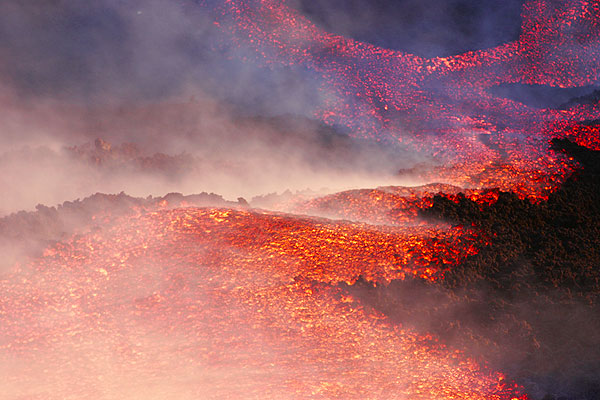
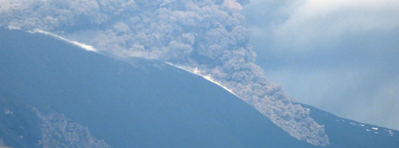
The Geological Institute carrying out reconnaissance work in the area of San Nicolás, where we can see that part of the cone that emitted pyroclasts in the northeast area has detached along the north slope, generating a new morphology with numerous lava flows and the partial collapse and abandonment of the lava tube that directed the North lava flow.
Otherwise, the accumulation of lava flows in the area of San Nicolas is generating a small lake.
Today, October 23, in the morning, at 10:22h, we are recognizing the northern part of the cone. It has collapsed.
There is lava spilling all over the northern slope.
--
Strombolian process continues
With constant variation of the cones and emergence of new foci.
--
Destruction of the pyroclastic cone to the northwest, a new emission center is opening from the collapse of this cone, which contributes the emission centers that were more to the northeast, part of the lava is already flowing over the eruptive cone, and the tube can be observed, which contributed all the lava to the north, has sunk and is forming a small lava lake in the area of San Nicolas with the crossing of the.... (almost inaudible)
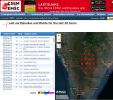
Perhaps the locations are tied to a GPS grid with low resolution; the sensors would match the location to the level of accuracy. It is similar to when you zoom in on a digital photo; at some point the pixel resolution will show up. The only reason the pattern shows up on the earthquake map is because there have been so many quakes, so close, and within such a short period of time.Yes; I went to Earthquake monitor - Earthquakes in 2021 - Latest Earthquakes in the world and zoomed into La Palma, off Morocco, North West Africa, and I get this picture. Very weird!
| Magnitude | ML 3.6 |
| Region | CANARY ISLANDS, SPAIN REGION |
| Date time | 2021-10-24 16:10:09.4 UTC |
| Location | 28.56 N ; 17.84 W |
| Depth | 12 km |
| Magnitude | ML 3.7 |
| Region | CANARY ISLANDS, SPAIN REGION |
| Date time | 2021-10-24 15:54:48.3 UTC |
| Location | 28.57 N ; 17.85 W |
| Depth | 10 km |
It's known that earthquakes and explosions, etc , can be caused by beaming so that is certainly a possibility IMO. Pulsing such action might be a way to fracture the earth until the lava is exposed to underground sea level and then kaboom, crack, splat.This of course does not prove there is no fiddling from somewhere, but given how much stress there is on a social level across the World, the Earth may feel like blowing the whistle. And perhaps it does.

You mean like Haiti:It's known that earthquakes and explosions, etc , can be caused by beaming so that is certainly a possibility IMO. Pulsing such action might be a way to fracture the earth until the lava is exposed to underground sea level and then kaboom, crack, splat.
On the other hand, if it is the earth doing it, well, I know just how she feels.

 cassiopaea.org
Whether there has been fiddling or not, psychopaths may get the blame anyway. This is indicated in the following excerpt, which however also mentions some reasons for "the Gulf Stream thing" that may apply to the current volcanic activities on La Palma.(L) I have a question. I've been waiting for somebody to ask it, but since nobody is going to ask it, I want to ask it: Was the Haiti earthquake an induced earthquake, or was it totally natural?
A: (Planchette swirls on board) INDUCED! Bet you didn't expect that, did you?!
Q: (L) Frankly, I didn't. Because I've already gone on record saying it wasn't. I just poo-pooed the whole idea as too far out there. (laughter) So now I've gotta...
(Joe) Well, it was the Russians who said that, wasn't it?
A: No!
Q: (Joe) Didn't you tell us the Russians reported that?
(L) The question I want to ask is, how do they induce earthquakes? (To Ark) How do you think they induce earthquakes? (Joe) Space-based satellite
(Ark) Well, just search the internet! (laughter) Yeah, it's on the internet. You create special waves that go into the earth and propagate in the right direction...
(L) I don't believe it. They don't have enough power to do that.
(Joe) I want to know who induced it?
A: U.S.
Q: (Joe) At the government level, or super-secret nonsense?
A: Secret gov.
Q: (L) And how did they do this? Was this from some kind of waves that Ark is talking about?
A: Close. And notice that no one is arguing with them right now!
Q: (L) In other words, you've got something that can do that, nobody's gonna mess with you.
(Ark) But the main question is, did they really want to induce it in the neighborhood of Haiti, or it was a mistake?
A: Yes, the prep was done.
Q: (Andromeda) So they intentionally did it to Haiti.
(Ark) What I would do, I would use a submarine and go near the fault, and do the job using these submarines as a so to say amplifiers for something. There are these faults under the ocean. It's enough to move this fault in the right direction with the right frequency, and you get it.
A: Too dangerous that way because the pulses would also destroy the sub. Better to use triangulated space-based weapons.
Q: (Belibaste) Why did they target Haiti specifically?
A: Close to South America. Convenient, oil, other factors of imperialistic nature.
Q: (Andromeda) Was it like a test?
A: No.
Q: (Burma Jones) Not a test, so they've used this thing a lot before?
(Joe) They used it on the Columbia.
A: Once or twice.
Q: (Joe) Used on the space shuttle.
(Psyche) That's why Chavez was so sure.
(Ark) It's probably much easier for the island than on the mainland...
(L) Yeah, because you've got separation with the ocean bed and different strata. It would be too uncontrollable if you started zapping a fault on a large land body.
(Andromeda) Like California?
(Joe) When they said, "notice how no one is arguing with them now", does that mean that most major nations in the world are aware that this was a...
A: Yes
Q: (Joe) Good way to shut people up.
A: Spy vs. Spy
Q: (L) Anybody else got anything pressing?
cassiopaea.org
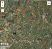
I went back to the link of the video with the pattern guy. He has struck gold. Within 48 hours he has gathered140,000+ views and 5000+ likes. His future is secured, there will soon be another swarm that will display a pattern. I tried to look for them in Crete, Indonesia, (attached) California and Hawaii, and they seem to be everywhere, or have been within the last 48 hours, just less intense than in La Palma.Q: (L) [...] Okay, so we've got that. Is there any follow-up question on the Gulf Stream thing? Oh, wait a minute... Read that back to me... {previous exchange is read back} What do you mean: "The cause is more than the oil"?
A: Internal planetary changes including magnetic field modifications.
Q: (L) And what is causing the internal planetary changes including the magnetic field alterations?
A: Both the change in the cosmic environment and the presence of foreign bodies in and near the inner solar system. {pause} Realm convergence.
Q: (L) Well, clearly human beings are really miniscule specks on this planet, and the planet itself is a miniscule speck in the galaxy, which is a miniscule speck in the universe. So, in a very large sense, we don't really count. So whatever happens, happens.
A: More or less, but remember that some consciousnesses "weigh" more than others. Also recall that "His eye is on the sparrow." While it may seem grim from your perspective, even you care about your smallest parts.
Q: (L) Well, it just seems like psychopaths have really screwed things up.
A: It is actually a bad time for them.
Q: (L) It's a bad time for them? What do you mean?
A: They will get all the blame!
| Magnitude | ML 2.7 |
| Region | CANARY ISLANDS, SPAIN REGION |
| Date time | 2021-10-24 22:06:39.8 UTC |
| Location | 28.56 N ; 17.85 W |
| Depth | 12 km |
More earthquakes in a manipulated grid pattern. They do not look natural.
EMERGENCY UPDATE LA PALMA!!!! EXTREMELY IMPORTANT INFORMATION !!!!
I am also inclined to be a little extra critical of the person "Off Grid desert farming...". He seems very alarmist, lose with facts and keen on seeing nefarious activity everywhere. A couple of weeks ago, he posted what he called drone photage of La Palma, which did not look like La Palma and from the comments was from Iceland. A week ago when a lava tsunami occurred in La Palma, he posted it saying that the MSM was suppressing it and that not only would it cause many deaths as people couldn't be evacuated, but also claiming that millions would die in the US as this was just the start of the 'inevitable' tsunami which he says is going to wipe out the US east coast.I went back to the link of the video with the pattern guy. He has struck gold. Within 48 hours he has gathered140,000+ views and 5000+ likes.
Notice they use three to four decimals. 28.564 degrees N and 17.8477 degrees W. There will still be a gird, but it will be much finer, and that is why we can not see it on the map.[...] If one compares the two different sets of numbers, we have that 28.564 degrees N matches with 28.56 N, while 17.8477 degrees W matches with 17.85 W. The difference is in the number of decimals they publish. Maybe their sensors are slightly different. Or maybe their raw data is the same, but EMSC-CSEM does not publish a number that pretends to be more accurate than they think the sensors can justify?
I am also inclined to be a little extra critical of the person "Off Grid desert farming...". He seems very alarmist, lose with facts and keen on seeing nefarious activity everywhere. [...] One could say that he is just caring about people and want to warn them, yet that to me is not what he is doing. Causing panic, posting misleading videos from different places than what is claimed, posting alarmist headlines with multiple exclamation marks, claiming as hard facts that 100 million people are going to their certain deaths is not helping anyone.[...] Videos from people who continually see apocalypse happening tomorrow and who sees themselves as rescuers with special insight and who post titled youtube videos titled "extremely important information!!!" or the like and normally all in capital letters, should be avoided or at least with a qualifier why this is worth looking at.
More earthquakes in a manipulated grid pattern. They do not look natural.
EMERGENCY UPDATE LA PALMA!!!! EXTREMELY IMPORTANT INFORMATION !!!!


La Palma volcano update: Quakes at La Palma are NOT artificial! https://bit.ly/3bov3Rr Live Accurate Earthquake Data From Spain https://bit.ly/2XhGy97 Earthquakes Today: latest quakes near La Palma volcano: past 24 hours https://bit.ly/3hLpMXk La Palma Quakes vs Depth Live Chart https://bit.ly/2XseTTkLIVE: La Palma Volcano Eruption, the Canary Islands https://bit.ly/3vFWrDM