Volcanoes Erupting All Over

5000 Terremotos en la isla de La Palma (Canarias) en los últimos dos meses.
No time to play #30DayMapChallenge , but wanting to participate, I will use something that I am doing these days. Day 1,#puntos#points . 5000 Earthquakes on the island of La Palma (Canary Islands) in the last two months.


La Palma Eruption Update: Two 5.0 Mag Earthquakes Over The Weekend as The Volcano Darkens The Sky!
Premiered 54 minutes ago Magnetic Reversal News
Moderate mag. 5.0 earthquake - La Palma Island https://bit.ly/3EDwW94 La Palma volcano update: Intense ash emissions continue, bad air quality in the Ariadne Valley https://bit.ly/3CA0Udz Latest quakes near La Palma volcano: past 24 hours https://bit.ly/3hLpMXk La Palma Quakes vs Depth Chart https://bit.ly/2XseTTk LIVE: La Palma Volcano Eruption, the Canary Islands https://www.youtube.com/watch?v=dTTm5... Analysis of the volcanic activity https://www.ign.es/web/vlc-serie-palma Seismicity on La Palma https://bit.ly/3nGxtAs Ground Deformation La Palma https://bitly.is/2ZOJICX 3D Earthquake Visualization @ La Palma https://bit.ly/3bxQyPw

They catch a volcanic ray on La Palma.

Video of the eruption and the ash dispersion from the Llano del Jable Astronomical Viewpoint at 2.30 pm (Canary time) / Video of the eruption and the ash dispersion from the Llano del Jable Astronomical Viewpoint at 2.30 pm (Canarian time)#LaPalma


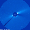
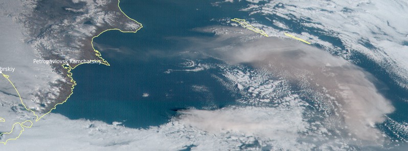
News from #Sabancaya ,#Karymsky ,#Cumbre Vieja and #Vulcano . http://earth-of-fire.com/2021/11/news-from-sabancaya-karymsky-cumbre-vieja-and-vulcano.html News from Sabancaya, Karymsky, Cumbre Vieja and Vulcano.
1635785227225.png
 

Attachments

  • cme_c3c.gif
    cme_c3c.gif
    4 MB · Views: 6
Last edited:
Vulcano, Aeolian Islands
30 Oct 2021 • Sicily, Italy

Opera-Momentaufnahme_2021-11-01_100601_www.emsc-csem.org_.jpg

Vulkane.net (by Marc Szeglat) writes following regarding earthquakes in the area of an already unsettled Vulcano volcano.

Lipari Islands: Earthquake in the Tyrrhenian Sea

State: Italy | Location: 14.87 ; 38.50 | Eruption: Fumarolic

Seismicity is elevated in the area of the Lipari Islands. Of particular interest are further earthquakes in the area of Vulcano. Since yesterday, there have been 3 tremors with magnitudes between 2 and 2.3. There, in addition to the increased seismicity, there are further signs that magma is rising. The volcano could be preparing for an eruption.

Off the northwest coast of Stromboli, it quaked today with M 2.1 at a depth of only 1 km.
Exciting times for volcanophiles!

My husband told me that he got a notification last week of an 3.8 M earthquake near Lipari Island (the island north of Vulcano). It appears that the area is turning more unsettled for the time being...
 
@thorbiorn - I am replaying here at the volcano's thread
La Palma experienced a quake in the morning 7:24 am (GMT+1) on October 30, but was it a magnitude 5.1, 5.0, 4.1 or 4.5? Did it happen at a depth of 5, 35, 39, or 40 km, and where exactly was the epicenter?
Interesting how an event can be listed in different ways. Perhaps the need for immediate reporting affects the initial accuracy. One could also imagine that national services and institutes may be more invested in analyzing their data after event and update their information, but in certain circumstances one can also imagine national services would be subject to political pressure.
At Telegram channel Emergencia La Palma, these inconsistencies are often mentioned, it is often observed that the National Geological Institute (ING) lowers the numbers of the earthquakes.

Almost every day a FB page, Volcanes y Ciencia Hoy Volcanoes and Science Today, publishes a report of the volcano on La Palma Island, had to make a Telegram Channel -Volcanes y Ciencia Hoy- because that page had problems days ago, something that happens nowadays when they go outside the official narrative.

548- 01/11/2021 20:30h Canarias.- ERUPTION OF THE ISLAND OF LA PALMA.- DAY 44.- LIGHTNING, EXPLOSIONS, EARTHQUAKES (4.4 the last one), MORE ASH, MORE LAVA, AND MORE NONSENSE.-. The volcano does not stop throwing ash and explosions, the tremor rises this afternoon, with an intense jet noise due to the exit of gases and from afternoon to afternoon an earthquake makes everything move, with vibrations in the windows, in the doors and without being able to leave the house due to the amount of ash in the air throughout the valley. There is no one who can live like this, protect yourselves well.

This ash gives very high values above 200 micrograms per cubic meter and in fact has forced to suspend classes for tomorrow in 5 municipalities of the island and to close the airport, it is impressive.

But it is not only throwing a lot of ash, but also a lot of lava that is rapidly descending from the cone in a myriad of channels and volcanic tubes, appearing in fountains and disappearing in sinkholes in an impressive way. When not all the flow enters or a big chunk comes down and gets stuck, it overflows, generating new spills that go down the hillside over the old lava flows, it is impressive.
THE LAVA FLOW: (In Spanish, Las Coladas)
The lava flow14 caused by the overflow of the channel that fed lava flow 13 is advancing at about 15-20 meters per hour to the west of the cogote mountain, downhill towards the sea with very fluid and hot lava, with two well-defined arms. It is about 200m from the access road to the port of Naos, so the problems only increase.
As if that were not enough, there have been some overflows further down in the area at the head of lava flow 13, which has given another lava flow that is bordering this flow on the southern edge and above this has widened in some places, partially covering some kipukas that were near Todoque.
The seismicity continues and in addition to strange noises in the Gomera sensor in the form of horizontal stripes that have been changing in frequency that I do not know what they are, and that look like volcanic glissandos (1) , that is to say that more magma is on the way, but it is not the only thing, we have had something else that looks in the same direction.
LONG PERIOD EARTHQUAKE:
es2021vknwa 01/11/2021 13:03:06 28.5577 -17.8358 10 km
IV M 4.0 mbLg NE FUENCALIENTE DE LA PALMA.ILP

Today's earthquake after noon has been special, it has been an earthquake with a very long coda or tail, especially in the sensor of La Gomera, a long period earthquake that has lasted more than 2 min, and that is an unmistakable sign of a depressurization of fluids and magma movement in depth ... or what is the same, there is more magma on the way to the eruptive mouth, almost nothing.

EDITED: And THE LAST one a few minutes ago.

en2021vlcky 01/11/2021 20:24:10 20:24:10 28.5694 -17.8245 38 km M 4.4 mbLg SW VILLA DE MAZO.ILP
You have seen the animation?... Didn't you see something weird? Look closely and you will notice that almost all the small earthquakes are in one area and the larger ones in another. This is due to a problem with the rock density model used by the IGN. It is denser than it really is. A problem known for years (in Tenerife and El Hierro) and that they do not want to change, they prefer to say that the seismicity in the Canary Islands is special and that they have to use a customized scale for the Canary Islands, so nobody knows what is going on, not even them.
SPECIFIC LOCAL MAGNITUDE SCALE FOR EARTHQUAKES IN THE CANARY ISLANDS - I'M HALLUCINATING IN COLORS - WHAT AN INTERNATIONAL RIDICULOUSNESS.
The IGN prepares a specific local magnitude scale for earthquakes in the Canary Islands
The reason is that the Richter calibration used was calibrated on the mainland, so it is convenient to adapt it to the reality of the islands to give more accurate results.
The National Geographic Institute (IGN) has developed a scale of magnitude of seismic movements specific to the Canary Islands, which will lead to transform the previous records to adapt them to the new formula, but the differences will be of a few tenths, IGN seismologist Juan Rueda told Efe.
The work is currently being submitted for publication prior to its integration into the calculation process and, when it is done, the magnitudes of the Canary Island earthquakes determined by the IGN will have a lower degree of uncertainty.
...
The American physicist had in California a Wood-Anderson seismograph with analog recording and said that if he measured the maximum amplitude of the wave in the record and made its logarithm, the result would be a measure of the energy. He also said that a parameter had to be removed depending on the place where the earthquake occurs and the place where the station is located, and therein lies the problem because "the rest of us are not in California, so the attenuation parameter to be removed from the logarithm of the amplitude is different depending on the place," said Juan Rueda.
What is usually done is to calibrate the Ritcher scale to each place, and that was carried out in peninsular territory and that is why the National Geographic Institute uses the magnitude mbLg. These letters correspond to m (magnitude), b (body, because the internal waves are measured), and Lg (because of the multiple waves that are registered in an earthquake, the Lg wave is used in the peninsula).
Thus, in the Canary Islands a formula made for a different territory is used, and in view of this situation, the National Geographic Institute has developed a new formula for the Canary Islands, where previously the magnitude of earthquakes was calculated according to the duration of the earthquake record, something that was carried out from analog records.
In this way, it was measured how long an earthquake lasted, a formula was applied and this gave a value of magnitude duration.

Juan Rueda emphasized that "all" the magnitudes are intended to give values similar to those of Ritcher in California, which leads different agencies to give magnitudes that present differences, but these are small.

The change that will be made for the Canary Islands will lead to homogenize the previous magnitudes with the new ones, as happened when the mbLg magnitude began to be applied in the islands, and it is done to avoid biases when comparing the magnitude of the earthquakes in different periods.

Juan Rueda has specified that when he says that the magnitude is determined by the amplitude of the seismic waves, it must be taken into account that an earthquake is registered in multiple seismic stations, so that an average of the magnitude values is made for each station.

And as there is a coefficient that depends on each station, it is different in each one, and "always" there is an uncertainty in the value of the magnitude, something that is due to the method of calculation and that the energy is not measured in the focus but in the distance, so you have to make a correction to extrapolate what would be the energy at the focus of the earthquake, he added.

In this context, he emphasized that it is a hoax to say that the IGN lowers the magnitude of earthquakes, and said that what happens is that the first calculation is automatic, it is carried out by a computer that is continuously analyzing the waveform.

When the computer detects an earthquake it measures the maximum amplitude, which is from "peak to peak", and then the analyst carries out a revision and most of the time this peak is something "isolated", so it is necessary to go to the maximum amplitude but sustained of the seismogram, which lowers the amplitude, and therefore the magnitude.

Juan Rueda reminded that the magnitude scale has no limit, but a seismic movement above 9 has never been registered.

Translated with www.DeepL
----------
These cheap excuses of the IGN for their lack of scientific rigor in their data and studies only show their inability to collaborate with the rest of the scientific world. The truth is that in a globalized world and they want to be the only ones who know what is going on, the rest of the world is not going to know.

Translated with www.DeepL
(1) from wikipedia: In music, a glissando (Italian: [ɡlisˈsando]; plural: glissandi, abbreviated gliss.) is a glide from one pitch to another (About this soundPlay (help·info)). It is an Italianized musical term derived from the French glisser, "to glide". In some contexts, it is distinguished from the continuous portamento. Some colloquial equivalents are slide, sweep (referring to the "discrete glissando" effects on guitar and harp, respectively), bend, smear, rip (for a loud, violent gliss to the beginning of a note),[1] lip (in jazz terminology, when executed by changing one's embouchure on a wind instrument),[2] plop, or falling hail (a glissando on a harp using the back of the fingernails).[3]
Music-glissando.png
 
@thorbiorn - I am replaying here at the volcano's thread
Thank you, @mabar! I attempted to learn more about the application of the Richter scale. There may be reasons for the varying numbers, and the efforts to create an adapted scale for La Palma. Here are a couple of excerpts from articles by the USGS that explain why measuring the magnitude of an earthquake is difficult and why there are different scales.
Moment magnitude, Richter scale - what are the different magnitude scales, and why are there so many?
Earthquake size, as measured by the Richter Scale is a well known, but not well understood, concept. The idea of a logarithmic earthquake magnitude scale was first developed by Charles Richter in the 1930's for measuring the size of earthquakes occurring in southern California using relatively high-frequency data from nearby seismograph stations. This magnitude scale was referred to as ML, with the L standing for local. This is what was to eventually become known as the Richter magnitude.

As more seismograph stations were installed around the world, it became apparent that the method developed by Richter was strictly valid only for certain frequency and distance ranges. In order to take advantage of the growing number of globally distributed seismograph stations, new magnitude scales that are an extension of Richter's original idea were developed. These include body wave magnitude (Mb) and surface wave magnitude (Ms). Each is valid for a particular frequency range and type of seismic signal. In its range of validity, each is equivalent to the Richter magnitude.

Because of the limitations of all three magnitude scales (ML, Mb, and Ms), a new, more uniformly applicable extension of the magnitude scale, known as moment magnitude, or Mw, was developed. In particular, for very large earthquakes, moment magnitude gives the most reliable estimate of earthquake size.

Moment is a physical quantity proportional to the slip on the fault multiplied by the area of the fault surface that slips; it is related to the total energy released in the earthquake.
The moment can be estimated from seismograms (and also from geodetic measurements). The moment is then converted into a number similar to other earthquake magnitudes by a standard formula. The result is called the moment magnitude. The moment magnitude provides an estimate of earthquake size that is valid over the complete range of magnitudes, a characteristic that was lacking in other magnitude scales.
What is noticeable above is that the magnitude scale is good for very large earthquakes, and that in general it is an estimate.

The difficulties of calculating the size of an earthquake.
How Big Was That Earthquake?
[...]
How do seismologists determine the size of an earthquake? This sounds like a simple question, and it is a fundamental task of earthquake monitoring in Yellowstone and elsewhere. Although simple in concept, in practice measuring the magnitude of an earthquake can be quite challenging. It’s not as easy as making the earthquake stand on a scale and reading the dial. In fact, methods to compute earthquake magnitudes have evolved considerably over the years and continue to evolve today.'
[..]
The Richter scale was an important development, but there were problems. First of all, the scale saturates for the largest earthquakes—that is, the scale is unable to accurately distinguish between an earthquake of magnitude about 7.0 and one that is in fact much larger. The other problem is that geology varies among different regions, meaning that the rocks may absorb differing amounts of energy between the earthquake source and the seismic station where the earthquake is recorded. Because of this variability, the method for determining Richter magnitudes usually must be modified for use in regions outside southern California.

To solve these problems, scientists developed a new magnitude scale called moment magnitude, sometimes written Mw.
Unlike the Richter scale, moment magnitude is based on a physical quantity of the earthquake source, the seismic moment, which represents the average fault slip multiplied by the area over which the slip occurs and by the stiffness of the surrounding rocks. The equations are written such that ML and Mw magnitudes are roughly comparable. Moment magnitude has now replaced the Richter scale as the standard for measuring large earthquakes worldwide (above about magnitude 5), and it is sometimes calculated down to about magnitude 3 in places where seismic networks are dense and high quality. But Mw has challenges—it's slower and more involved to calculate than other magnitudes like ML, requiring careful modeling of the earthquake waveforms. And smaller earthquakes are not readily amenable to this type of processing, although determining Mw for smaller earthquakes is an area of current research.

Earthquakes in the Yellowstone area are monitored by the University of Utah Seismograph Stations (UUSS) in partnership with the U.S. Geological Survey. In addition to ML and Mw, UUSS also uses a scale called “coda magnitude” (Mc) to characterize earthquakes in the region. This magnitude measurement is based on how long it takes for the seismic energy to return to background levels after the earthquake. Mc is designed to be compatible with ML.
The above excepts show that there are different considerations when deciding on the expression of the mathematical model depending on the location. Since it is 50 years since the last eruption on La Palma, it is possible there was not enough data to develop a suitable model of the seismic activity near the volcano. Apparently earthquakes near volcanoes are generally below 6, and since the magnitude scale is more suitable for large quakes it may explain the variations and the need to refine the scale to local conditions.

From this page, one can zoom in on La Palma and find that IGN has several stations installed:
Screenshot 2021-11-02 130941.png
The latest seismic activity on La Palma
A moderator on one of the live feeds posted two links in the chat: Instituto Geográfico Nacional and IGN-LA PALMA-SIS The last has these images of the activity, since the beginning:
PA_SIS_rsam_CENR_serie.jpg
From the last few days:
PA_SIS_rsam_CENR_us.jpg
If one lives in an earthquake prone area, one can try out a seismograph app, or participate with the app from the Earthquake Network. Various regions of the planet have their own centers. The European — Mediterranean service, EMSC-CSEM advertise their own app, Lastquake, on their homepage.

Another way to estimate the size of earthquakes is to find out what people on the location experience. The geological services ask for direct observations and have forms one can fill out. To translate observations to numbers, there is the Mercalli Scale. The differences with the Richter scale are explained here:

Comparison chart
Mercalli Scale versus Richter Scale comparison chart
Edit this comparison chartMercalli ScaleRichter Scale
MeasuresThe effects caused by an earthquakeThe energy released by an earthquake
Measuring ToolObservationSeismograph
CalculationQuantified from observation of the effects on earth’s surface, humans, objects and man-made structuresBase-10 logarithmic scale obtained by calculating logarithm of the amplitude of waves.
ScaleI (not felt) to XII (total destruction)From 2.0 to 10.0+ (never recorded). A 3.0 earthquake is 10 times stronger than a 2.0 earthquake.
ConsistencyVaries depending on distance from epicenterVaries at different distances from the epicenter, but one value is given for the earthquake as a whole.

Measurement
The Mercalli Intensity Scale measures the intensity of an earthquake by observing its effect on people, the environment and the earth’s surface.

The Richter Scale measures the energy released by an earthquake using a seismograph. A base-10 logarithmic scale is obtained by calculating the logarithm of the amplitude of waves recorded by the seismograph.

Comparing the Scales
Intensity (Mercalli)Observations (Mercalli)Richter Scale Magnitude (approx. comparison)
I​
No effect
1 to 2​
II​
Noticed only by sensitive people
2 to 3​
III​
Resembles vibrations caused by heavy traffic
3 to 4​
IV​
Felt by people walking; rocking of free standing objects
4​
V​
Sleepers awakened; bells ring
4 to 5​
VI​
Trees sway, some damage from falling objects
5 to 6​
VII​
General alarm, cracking of walls
6​
VIII​
Chimneys fall and some damage to building
6 to 7​
IX​
Ground crack, houses begin to collapse, pipes break
7​
X​
Ground badly cracked, many buildings destroyed. Some landslides
7 to 8​
XI​
Few buildings remain standing, bridges destroyed.
8​
XII​
Total destruction; objects thrown in air, shaking and distortion of ground
8 or greater​
If one goes to Earthquakes - Earthquake today - Latest Earthquakes in the World - EMSC and scrolls down, one can for larger quake find a number that indicates the intensity. They will also say how many responses they had.

The question of accuracy
The last couple of days the SO2 emissions are down to now 4990 t/day while the total outflow is still 66 m3. If one gives a number like 4990 t/day then one would expect an accuracy of ± 5 t. just like 66 m3/s would indicate an accuracy of ± 0.5 m3. Clearly this is exaggerated accuracy. Similarly, it may not be realistic to get the earthquake magnitude accurate down to the last tenth.
EMSC-CSEM reports the quake on November 1, 20:24 UTC as 4.0:
MagnitudeML 4.0
RegionCANARY ISLANDS, SPAIN REGION
Date time2021-11-01 20:24:09.9 UTC
Location28.58 N ; 17.72 W
Depth30 km
The intensity on the Mercalli scale of the above quake based on three people was IV, corresponding to 4 on the Richter scale.
IGN reports it as a 4.6 at 36 km and IPMA registers a 3.8 at 43 km:
2021-11-01 20:24:1128.55 N17.93 W43 km3.8Canary Islands, Spain RegionIPMA
Last time I compared the services, it was a difference of about 1 and now of 0.8 (4.6-3.8). On each occasion, IGN had the higher number. Who is right? Is one better than the other, or is the number the average ± 0.5. The depth varies this time between 30 km and 43 km, with an average around the figure that IGN gives, 36 km.

Let go of numbers?
What is seen on the surface is fire, lava, clouds of sulfur and ash. What is felt is, a roaring noise, trembling in the ground and lots of small earthquakes. The volcano does not seem to care much about numbers, or time, air-pollution, property rights, destruction, or is it construction? Is it time to let go of numbers, and let it do its thing?
 
Karymsky volcano has erupted, spewing ash 10.5 kilometers into the sky.

By VN - 5 Nov 2021

Posted by Teo Blašković on November 5, 2021

Published on Nov 4, 2021 (1:18)
 
Cumbre Vieja, La Palma, Spain
Collection of photos • 2-7 Nov 2021

The first image made by Mario Picazo yesterday, is simply dazzling.

The photos towards the end, made by Emilio Morenatti, speak with a different visual language not often seen, by highlighting abandoned details in the ash deposits.

Mario-Picazo.jpg
Photo by Mario Picazo


ABIÁN-SAN-GIL.jpg
Photo by ABIÁN-SAN-GIL

by-David-Rosario.jpg
Photo by David Rosario

252351338_3059228937651642_4525623273724820414_n-1.jpg

253219901_4796033883794646_5979772090043953375_n.jpg
Sulfur deposits visible


All images below made by Emilio Morenatti

Emilio-Morenatti_AP.jpg
1200x10.jpg
1200x07.jpg
1200x08.jpg
1200x09.jpg
1200x06.jpg
1200x05.jpg
1200x04.jpg
1200x02.jpg
1200x01.jpg
1200x0.jpg
 
_-2021-11-07-at-21.43.37.jpg

Montagne Pelée, Martinique, France
6 Nov 2021

🇩🇪 Vulkane.net writes

Montagne Pelée with microseismicity

State: France | Coordinates: 14.82, -61.17 | Eruption: microseismicity

The OVSM reported in last week's Bulletin that seismometers detected 25 weak earthquakes at Montagne Pelée on Matinique (Caribbean). The strongest had a magnitude of 1.1 and was thus still in the range of microseismicity. The hypocentres were shallow, more precisely, between 0.9 and 2.1 km depth. The quakes indicate that small cracks form in the rock due to the rise of magmatic fluids.

Whether this is magma is unclear at this time. There is a degassing zone, or submarine fumarole field, offshore that remains active. The IPGP took water samples to trace the origin of the gases. Since 2019, scientists have been observing the effects described. They indicate a slow awakening of the volcano. (DeepL)

_-2021-11-07-at-21.44.08.jpg

StPierre now.jpg

large.jpg


Montagne Pelée is infamous

for it's devastating eruption on 8 May 1902 when a glowing avalanche (Nuée Ardente) rolled down the slopes hitting the 7 km distant city of St Pierre, killing 30.000 people within minutes. Some photos from 1902

9aab806db3043e299dc2ce8f08e4a8fd.jpg

b4361dea1ccc1716e92e6ce86bb2b8e6-1.jpg

Collectie_Nationaal_Museum_van_Wereldculturen_TM-60062369_Uitbarsting_van_de_Mt._Pelee_Martini...jpg
Wallibu-river-valley-filled-with-pyroclastic-flow-deposits,-craters-are-from-secondary-steam-e...jpg
Wallibu river valley filled with pyroclastic flow deposits, craters are from secondary steam explosions.

iu.jpg
Nuée Ardente - Glowing Avalanche. Martinique. 1902.
 
Ooops. Correction :-[

I remember that I did wanted to check if "Bolivia" really was the right name / place in my map... (it should have been Peru of course). So, creating a larger entry just 15 minutes before rushing to work and still not dressed in uniform either :whistle:... it all was a little too tight for checking for errors; therefore I am sorry for the mistake.

Here is the correct map (i hope).

_-2021-11-07-at-21.43.37.jpg
 
About Cumbre Vieja volcano at La Palma, hereafter a link that shows before & after map from juxtaposition of photos of La Palma island & lava flow. Can zoom & move view:

Comparative map
Last update: Thursday 11/11/2021 at 11:00h. (image of the area affected by the eruption, captured by DRON flight by TICOM Soluciones SL). Use the search engine on the right to locate streets and portals.

Very impressive as how destructive the volcano is while it makes the island bigger as it creates more land surface by moving into the ocean.

Also from Volcano Discovery:

A magnitude 5.0 quake hit 36 km below the island this morning at 3.37 a.m. and was felt by thousands of people.
On the other hand, shallower quakes have become less in numbers and magnitude with "only" 75 quakes in total during the latest 24 hours.

Added: Seismic datas.
 
Cumbre Vieja Impressive samples collection with different cooling made last night at la Playa de Los Guirres, La Palma:


Sample collection at la Playa de Los Guirres at 2:00 am, with different types of cooling. Samples cooled with normal water produced large crystals, samples cooled in sea water produced much more massive samples. IGME and GIETMA (UME)

Images recorded by the Aerial Work Service of the #IGME (#STA) together with the Emergency and Rescue Group (#GES) of the Canary Islands Government.
 
Back
Top Bottom