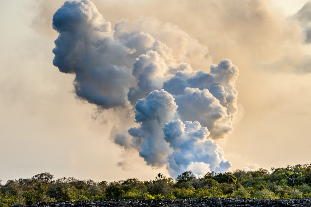
From a graphic perspective, this capture of Cumbre Vieja eruption is outstanding and very well framed!

You are using an out of date browser. It may not display this or other websites correctly.
You should upgrade or use an alternative browser.
You should upgrade or use an alternative browser.
Volcanoes Erupting All Over
- Thread starter Laura
- Start date
Volcanic Eruption In Germany - It's Boiling! Scientists Sure: "It Will Break Out One Hundred Percent"!
October 15, 2021While the world looks spellbound on the pictures of the volcanic eruption of the volcano "Cumbre Vieja" on the Canary Island of La Palma, a German volcano fills quietly with magma. The scientists of the Seismological Service Southwest are agreed that there will soon be a volcanic eruption in Germany as well.
Signs of volcanic eruption are increasing
According to the scientists, the affected region is under the Laacher See in the Eifel. For years, researchers have been observing geological processes there that indicate increased volcanic activity. Apparently the reservoirs under the lake are already filling with magma. In the opinion of the scientists, an early outbreak is only a matter of time.
Boiling water and smaller earthquakes have already been observed. Both signs are considered to be indicative of the movement of magma underground. These quakes are also known as DLF earthquakes. They take place in the upper part of the earth's mantle and have low oscillation frequencies.
Experts are certain: the volcano in the Eifel will erupt
Regarding the current situation at the Laacher See, a scientist says: “DLF earthquakes are regarded worldwide as an indication of the movement of magmatic fluids at great depths. Such earthquakes can be regularly observed under active volcanoes, for example in Iceland, Japan or Kamchatka. ”In addition, the Bonn geology professor Ulrich Schreiber is certain that the volcano in Germany is guaranteed to erupt again. Schreiber confirmed this to the daily “Express”: “At some point there will definitely be another outbreak. However, it is unlikely that it could start tomorrow ”. The last eruption on Laacher See took place a good 13,000 years ago.
(Translated with GTranslate)
XPan
The Living Force
Volcanic Eruption In Germany - It's Boiling! Scientists Sure: "It Will Break Out One Hundred Percent"!
October 15, 2021
While the world looks spellbound on the pictures of the volcanic eruption of the volcano "Cumbre Vieja" on the Canary Island of La Palma, a German volcano fills quietly with magma. The scientists of the Seismological Service Southwest are agreed that there will soon be a volcanic eruption in Germany as well.
Signs of volcanic eruption are increasing
According to the scientists, the affected region is under the Laacher See in the Eifel. For years, researchers have been observing geological processes there that indicate increased volcanic activity. Apparently the reservoirs under the lake are already filling with magma. In the opinion of the scientists, an early outbreak is only a matter of time.
Boiling water and smaller earthquakes have already been observed. Both signs are considered to be indicative of the movement of magma underground. These quakes are also known as DLF earthquakes. They take place in the upper part of the earth's mantle and have low oscillation frequencies.
Experts are certain: the volcano in the Eifel will erupt
Regarding the current situation at the Laacher See, a scientist says: “DLF earthquakes are regarded worldwide as an indication of the movement of magmatic fluids at great depths. Such earthquakes can be regularly observed under active volcanoes, for example in Iceland, Japan or Kamchatka. ”In addition, the Bonn geology professor Ulrich Schreiber is certain that the volcano in Germany is guaranteed to erupt again. Schreiber confirmed this to the daily “Express”: “At some point there will definitely be another outbreak. However, it is unlikely that it could start tomorrow ”. The last eruption on Laacher See took place a good 13,000 years ago.
(Translated with GTranslate)
But these articles always pop up in Germany
as soon there is a dramatic eruption going on in the world, such as Iceland earlier and now on La Palma... I guess the German media is "proud" of their little Eifel Volcanic area, the closest thing they can come up with, if any.
I have not heard or read of any increased volcanic activity in the German Eifel Area. Yes CO2 gases seep though the Laacher Lake, and there are a few micro earthquakes now and then. Which it has done for ages.
Unsettled and "unsettled"
I mean those areas, like most other hotter spots, are well surveilled and even the slightest signs are registered, in terms of tremor, micro earthquakes, gas increase, etc - and I am sure that if that would happen - with proof and not media interpretation - it would then quality for an area to be called 'unsettled'. (I think of Vulcano 2021 north of Sicily among the Aeolian Islands, and to some degree even Campi Flegrei 2021 Pozzuoli, west of Napoli, where increased seismic activity has been going on as well a 83 cm lift).
But it doesn't really tell a clear story, if those areas are really preparing to erupt.
Good is, that keen eyes are kept on volcanic areas, but the media buzz, we could be without.
Chad
The Living Force
1st tweet shows a 'volcanic ash devil' filmed at La Palma. It can be seen more clearly in the 2nd tweet as a photograph:
Chad
The Living Force
Volcano discovery reports that tremors continue in the area around Vatnafjöll volcano, Iceland, following an M5.2 quake on Thursday last week.
It also reports on an increase of tremors in the region of Hekla volcano, Iceland, north of Vatnafjoll. It says Hekla is considered to be one of the most active and most dangerous volcanoes in the region, and that it's "statistically overdue" an eruption.
Tremors around Hekla:
Last weeks earthquake near Vatnafjöll volcano, that was recalculated from M4.8 to M5.2
It also reports on an increase of tremors in the region of Hekla volcano, Iceland, north of Vatnafjoll. It says Hekla is considered to be one of the most active and most dangerous volcanoes in the region, and that it's "statistically overdue" an eruption.
Tremors around Hekla:
Hekla volcano (Iceland): increased number of earthquakes in the area
Mon, 15 Nov 2021, 21:05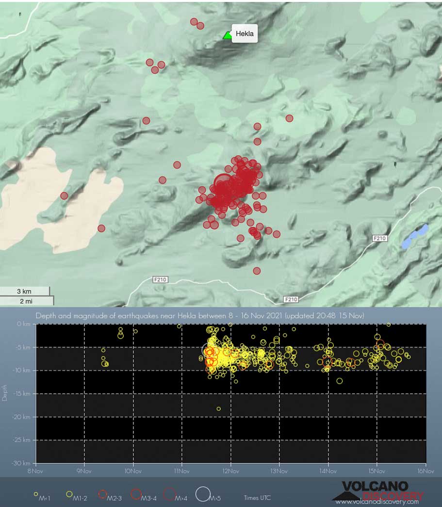
Hekla volcano (Iceland): increased number of earthquakes in the area
Hekla volcano (Iceland): news & activity updates / VolcanoDiscoverywww.volcanodiscovery.com
21:05 PM | BY: T

Earthquakes near Hekla volcano in the past 7 days
Aftershocks of Thursday's strong magnitude 5.2 quake under neighboring Vatnafjöll volcano continue with more than 50 tremors detected over the past 48 hours.
An increased number of quakes has also been occurring under Hekla volcano immediately to the north, most of them under the southwestern and western flanks. The problem is that Hekla, one of the country's most active volcanoes, and one of its most dangerous ones, is statistically overdue for an eruption, but typically does not give much warning signs such as earthquake swarms. Very often, the eruptions start with little to no warning time.
Whether last week's quake and the now continuing aftershocks will influence Hekla remains an open question, but the volcano is being monitored very closely.
Last weeks earthquake near Vatnafjöll volcano, that was recalculated from M4.8 to M5.2
Strong magnitude 5.2 earthquake at 6 km depth
11 Nov 13:27 UTC: First to report: VolcanoDiscovery after 6 minutes.
Strong mag. 5.2 earthquake - Iceland: 1.5 Km WSW of Vatnafjöll on Thursday, Nov 11, 2021, at 01:21 pm (Reykjavik time)
Detailed info, map, data, reports, updates about this earthquake: Strong mag. 5.2 earthquake - Iceland: 1.5 Km WSW of Vatnafjöll on Thursday, Nov 11, 2021, at 01:21 pm (Reykjavik time) -www.volcanodiscovery.com
11 Nov 13:29: Now using data updates from IMO
11 Nov 13:34: Magnitude recalculated from 4.8 to 5.0. Hypocenter depth recalculated from 3.9 to 3.6 km (from 2.4 to 2.2 mi).
11 Nov 13:37: Magnitude recalculated from 5.0 to 5.2. Hypocenter depth recalculated from 3.6 to 5.6 km (from 2.2 to 3.5 mi).
Update Thu, 11 Nov 2021, 13:33
Moderate magnitude 4.8 earthquake 65 km east of Selfoss, Iceland
")
4.8 quake 11 Nov 1:21 pm (GMT +0)
An earthquake of magnitude 4.8 occurred around noon on Thursday, November 11th, 2021, at 1:21 pm local time near Selfoss, Sveitarfélagið Árborg, South, Iceland, as reported by the Icelandic Met Office (IMO).
According to preliminary data, the quake was located at a very shallow depth of 3.9 km. Shallow earthquakes are felt more strongly than deeper ones as they are closer to the surface. The exact magnitude, epicenter, and depth of the quake might be revised within the next few hours or minutes as seismologists review data and refine their calculations, or as other agencies issue their report.
Our monitoring service identified a second report from the German Research Centre for Geosciences (GFZ) which listed the quake at magnitude 5.0. A third agency, the European-Mediterranean Seismological Centre (EMSC), reported the same quake at magnitude 5.0.
Based on the preliminary seismic data, the quake should not have caused any significant damage, but was probably felt by many people as light vibration in the area of the epicenter.
Weak shaking might have been felt in Hvolsvollur (pop. 900) located 32 km from the epicenter, Hella (pop. 780) 36 km away, Vestmannaeyjar (pop. 4,200) 59 km away, Selfoss (pop. 6,500) 65 km away, Hveragerdi (pop. 2,300) 74 km away, and Thorlakshofn (pop. 1,500) 84 km away.
Other towns or cities near the epicenter where the quake might have been felt as very weak shaking include Reykjavik (pop. 118,900) located 111 km from the epicenter, Kopavogur (pop. 31,700) 111 km away, and Hafnarfjordur (pop. 26,800) 112 km away.
XPan
The Living Force
Vulcano. Aeolian Islands, Sicily
24 Nov 2021, Italy

"50/50 chance for an eruption" according to INGV Sicilian chief vulcanologist Mauro Coltelli, telling the press in the latest statement.[Earlier 250 or 300 people have already been evacuated due to signs of gas poisoning in people as well animals]
Via Marc Szelgat's German site "Vulkane.net", he wrote today following
Stromboli. Aeolian Islands - Sicily
24 Nov 202, Italy
Etna. Sicily - Italy
22-23 Nov 2021

24 Nov 2021, Italy
"50/50 chance for an eruption" according to INGV Sicilian chief vulcanologist Mauro Coltelli, telling the press in the latest statement.[Earlier 250 or 300 people have already been evacuated due to signs of gas poisoning in people as well animals]
Via Marc Szelgat's German site "Vulkane.net", he wrote today following
Vulcano: Extreme carbon dioxide concentrations
Yesterday the INGV published the weekly bulletin on the events on Vulcano. The most striking feature of this bulletin is that the emission of carbon dioxide is described as very high and anomalous.
The value is given with 13743 g/m2/day and was measured crater area. Already since the weekend evacuations in the place Porto di Levante are considered, since the carbon dioxide concentrations were also there partly worryingly high.
Carbon dioxide is heavier than oxygen and can displace it near the ground or in depressions from the air we breathe, with the result that living beings suffocate. The gas escapes from magma and is considered an early indicator of rising magma.
Sicilian chief volcanologist Mauro Coltelli (INGV) told the press that there is about a 50/50 chance of an eruption. The situation on Vulcano therefore remains tense and even if no eruption should follow, the situation for the local people will remain uncertain for a while.
Stromboli. Aeolian Islands - Sicily
24 Nov 202, Italy
Stromboli: Normal activity level
The INGV certifies a normal activity level of the liparic Stromboli. This is remarkable, because the activity in the months after the big eruptions was classified as low for a long time. Between 14-25 strombolian eruptions are registered per hour.
Stronger representatives of their kind may well occur. The carbon dioxide emission is described as high.
The ratio of different helium isotopes to each other is also striking. These are early indicators that magma is rising from greater depths. I also find the increased quake activity in the Tyrrhenian Sea east of Stromboli striking. So, everything is normal, the only question is, for how much longer?
Etna. Sicily - Italy
22-23 Nov 2021
23 Nov 2021
Tonight, the tremor on Etna briefly rose into the red. A second peak scratched the red. In the previous days, ash emissions from the northeast crater were observed from time to time. Currently, the summit is shrouded in clouds, but it is possible that the volcano is preparing for an eruption.
22 Nov 2021
Yesterday, INGV reported weak ash emissions from the northeast crater. The volcanic ash rose only a few hundred meters high and was quickly dispersed by the wind [see photo above]. In addition, a horseshoe-shaped vortex (Etna's famous smoke rings) was reported.
Steam rings usually form in the wake of deep-seated explosions.
MIROVA detected a weak thermal anomaly. The remaining parameters are inconspicuous so far, but we know how quickly the situation at Etna can change.
Sangay volcano has erupted, spewing ash 6.4 kilometers into the sky.
 www.volcanodiscovery.com
By: VN - 24 Nov 2021
www.volcanodiscovery.com
By: VN - 24 Nov 2021
Sangay Volcano Volcanic Ash Advisory: CONS VA EMS. to 21000 ft (6400 m)
Sangay volcano (Ecuador) eruption news & activity updates
www.volcanodiscovery.com
Activity had been weaker throughout the night and less lava was visible at night compared to previous days, but this changed dramatically in the morning: at around 9 a.m. local time, an episode of sudden increase in the emission of lava occurred at the main effusive vent, and around 11 o'clock, from some of the most eastern emission points, a new voluminous and very liquid lava flow began to pour out towards the southwest, traveling parallel to the previous flow labeled #10.
The new lava flow quickly reached the southernmost end of the existing flow field and invaded new land, destroying a photovoltaic station and the Las Manchas cemetery. Although its advance has slowed down to about 25 m per hour later in the day, it is still threatening other urbanized areas, all of which have already been evacuated.
The new lava flow quickly reached the southernmost end of the existing flow field and invaded new land, destroying a photovoltaic station and the Las Manchas cemetery. Although its advance has slowed down to about 25 m per hour later in the day, it is still threatening other urbanized areas, all of which have already been evacuated.
La Palma volcano. Advancement of the new lava flow emerging from the new fissure at 5:15 pm Canarian time from Las Manchas. It moves at 600 m / h
irony
Terrible images on La Palma. This day the new lava flow has buried a cemetery.
The La Palma volcano opened a new mouth this morning, to the southwest of the main cone and at a lower elevation, in the Las Manchas area. On the way, it began to emit lava that flowed with great speed and has devastated several houses in addition to reaching and burying the Las Manchas cemetery, where about 3,700 people are buried.
El volcán abre una nueva boca y sepulta parte del cementerio de Las Manchas
XPan
The Living Force
Cumbre Vieja, LaPalma, Spain
Photo Impressions 26-28 Nov 2021
Some beautiful images photographers have taken at the La Palma eruption site during the past days.

Photo by "@urs.leutenegger"


The rain storm
26 Nov 2021
At the same time during the storm around 26 Nov 2021, the rainfalls were not that much as originally feared. The East Side of La Palma in and around the active volcanic region, received between 5 to 43 mm rain - without creating any lahars (ash mixed with water). On the NE side however, 232 mm rain fell at the most.
 Lapalma1.net (by Manfred Betzwieser ) wrote:

Photo Impressions 26-28 Nov 2021
Some beautiful images photographers have taken at the La Palma eruption site during the past days.
Photo by "@urs.leutenegger"
The rain storm
26 Nov 2021
At the same time during the storm around 26 Nov 2021, the rainfalls were not that much as originally feared. The East Side of La Palma in and around the active volcanic region, received between 5 to 43 mm rain - without creating any lahars (ash mixed with water). On the NE side however, 232 mm rain fell at the most.
Lapalma1.net (by Manfred Betzwieser ) wrote:The heavy downpour came down on the east side of La Palma. In the western part of the island, the downpour was limited. The dreaded mudslides or lahars in the metre-thick layers of ash did not occur. The passage of the Atlantic front recorded more than 3,000 lightning strikes. Specifically, the National Meteorological Agency (Aemet) recorded 3,151 lightning strikes between 9 pm on Thursday and 7 am on Friday.
Chad
The Living Force
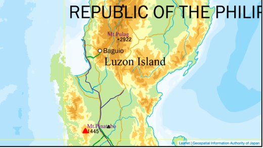
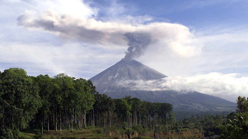
Earlier today a 'weak explosion' along with unusual seismic and infrasound signals have been detected at Mount Pinataubo, Phillippines. According to the article, the last time it erupted was 1991 and was considered the 2nd largest eruption of the 20th Century.
'Weak explosion' recorded & unusual seismic signals at Mount Pinatubo - last erupted in 1991, 2nd largest of the 20th century
Zacarian Sarao
Inquirer
Tue, 30 Nov 2021 05:21 UTC
© INQUIRER
FILE - The crater lake formed after Mt. Pinatubo erupted in 1991, shown in this file photo, has become a major attraction for outdoor enthusiasts, with trails opened in Tarlac and Zambales provinces.
A "weak explosion" was recorded at Mt. Pinatubo on Tuesday, said the Philippine Institute of Volcanology and Seismology.
In its latest bulletin, Phivolcs said the explosion was recorded between 12:09 p.m. and 12:13 p.m.
"The event produced a plume that was detected by the Himawari-8 Satellite and reported to Phivolcs by the Tokyo Volcanic Ash Advisory Center," said Phivolcs.
From Tokyo Volcanic Ash Advisory Center
"The seismic and infrasound signals are not typical of known volcanic processes and are currently being evaluated together with other potential sources," it added.
Phivolcs explained that there has only been very low seismic activity in the past days. The Pinatubo Crater Lake yields low diffuse volcanic carbon dioxide flux at only 257 tonnes per day.
However, Phivolcs warned the public not to enter the volcano's vicinity at this time.
Local government units were advised to prohibit entry into Pinatubo Crater "until the source of the above explosion event has been determined and to report to us any related information. "
"Communities and local government units surrounding Pinatubo are reminded to be always prepared for both earthquake and volcanic hazards and to review, prepare and strengthen their contingency, emergency, and other disaster preparedness plans," Phivolcs said.
Mt. Pinatubo last erupted on June 15, 1991, and was considered the second-largest eruption of the 20th century.

XPan
The Living Force
Pinatubo, Phillipines
1486 meter | 4875 ft height • 30 Nov 2021
German Vulkanet.net by Marc Szeglat about that a (phreatic) eruption at Mt Pinatubo has been confirmed [see photo below). (In the end I add some photo impressions people took from the 1991 eruption at Pinatubo Volcano).

Pinatubo, 1991 - VEI 6 eruption (memory lane)
photo impressions gathered from the Internet


At reddit i found a few comments (from 2015) about people who according to their writings, where near the 1991 eruption site (Clark Air Force Base)
1486 meter | 4875 ft height • 30 Nov 2021
German Vulkanet.net by Marc Szeglat about that a (phreatic) eruption at Mt Pinatubo has been confirmed [see photo below). (In the end I add some photo impressions people took from the 1991 eruption at Pinatubo Volcano).
Volcano Update 30 Nov 2021 • Pinatubo
The phreatic eruption at Pinatubo has been officially confirmed.
Country: Philippines | Coordinates: 15.13, 120.35 | Eruption: steam emission
This morning it was not yet clear whether there was indeed an eruption at the Philippine volcano Pinatubo. In the meantime, an eruption cloud was visually confirmed and also detected on satellite photos. However, the eruption cloud consisted almost entirely of water vapour and gas. It contained only little volcanic ash and was apparently of phreatic origin. For this, however, the cloud rose unusually high. Perhaps observations by volcanologists on site will reveal more precisely what happened.
PHILVOLCS recently issued the following statement, which is available here in automatic translation:
"Based on visual reports of an eruption plume and seismic, infrasound and satellite detections, DOST-PHIVOLCS confirms that a phreatic eruption occurred at Pinatubo crater between 12:09 and 12:13. The event was also confirmed after the AFP disposed of ordnance on the northern flank of Pinatubo at noon today, which has nothing to do with the volcano's condition. So far, there are no reports of ash fall from communities in Zambales over which the eruption plume spread. Considering that the volcano's seismic activity has been very low in recent days and a low diffuse volcanic CO2 flux has been measured at Pinatubo crater lake, as well as the high infrasound and seismic energy released by the eruption, the event was likely triggered by surface hydrothermal processes beneath the edifice."
Pinatubo killed hundreds of people in 1991
Some readers may wonder why the steam explosion at Pinatubo is given so much space here? Pinatubo is responsible for one of the most powerful eruptions of the last century, generating a VEI 6 eruption in 1991. Naturally, people are concerned when such a volcano shows signs of awakening. At that time, a lava dome grew in the crater and its explosion produced large pyroclastic flows and ash clouds. 875 people were killed.
Pinatubo, 1991 - VEI 6 eruption (memory lane)
photo impressions gathered from the Internet
At reddit i found a few comments (from 2015) about people who according to their writings, where near the 1991 eruption site (Clark Air Force Base)
yru1
I was there, stationed at Clark Air Force Base when it happened. Scariest 24 hours of my life. Simultaneously with the volcano eruption, there was a massive earthquake AND a typhoon hit the island. 24 hours of darkness with a typhoon-force sandblaster stripping all of the vegetation and a lot of the wildlife. And then just for giggles, boulders the size of a small car falling out of the sky. But hey, did I mention the free boat ride courtesy of the U.S. Navy? Thanks to the sailors of the Pacific Fleet for saving our bacon.
ursacrucible
I was also there, my Dad stationed in Clark. We were supposed to go to Subic but my Mom had a strange dream and told my Dad we'd stay near the base in a house a friend of our's owned. Turned out to be a good idea, the typhoon drowned Subic in ash and mud, my Dad spent most of his time there digging people out of collapsed buildings.
I was 8, it was dark as night for almost three days, typhoons and earthquakes. My mom is still surprised with how much I remember, but it's like, how could I possibly ever forget?
We were there until it was over, then drove ourselves to La Union several days later and waited for the official evacuation, but at that point it was mostly the Air Force getting us to my Dad's family in the states. That was the last time we got to ride in those cool airplanes with the netting down the middle to Cebu, or the backwards facing seats to Guam.
It was a crazy experience. My husband is always trying to remind me to write it all down for my kids to read someday.
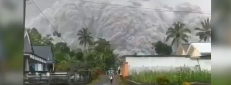
Semeru volcano has erupted, spewing ash 15.2 kilometers into the sky.
 watchers.news
Posted by Teo Blašković on December 4, 2021
watchers.news
Posted by Teo Blašković on December 4, 2021
 www.rt.com
4 Dec, 2021
www.rt.com
4 Dec, 2021
Published on Dec 4, 2021 (1:36)
High-level eruption at Semeru volcano, ash to 15.2 km (50 000 feet) a.s.l., Indonesia
A high-level eruption took place at Semeru volcano, East Java, Indonesia at around 08:20 UTC on Saturday, December 4, 2021. The Aviation Color Code was raised to Red. The eruption comes just two days…
watchers.news
Residents flee massive ash cloud from erupting volcano (VIDEO)
A volcano erupted on the Indonesian island of Java on Saturday, reportedly obscuring the sun with a massive cloud of ash, and sending locals into a panic.
Published on Dec 4, 2021 (1:36)
Trending content
-

-

-
Thread 'Coronavirus Pandemic: Apocalypse Now! Or exaggerated scare story?'
- wanderingthomas
Replies: 30K -