Watch the skies and land and oceans

Massive flood on the road due to intense rainfall in the Araklı of Trabzon province, Turkey​


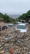
Heavy flooding and storms washed away cars in Guatemala​


Bebinca typhoon in China​


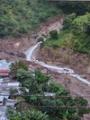
“Unprecedented” rain triggered floods and landslides in Japan​


Small tsunami waves hit Japanese islands south of Tokyo​

A half-meter tsunami hit the coast of Yaene on Hachijo Island at 8:58 a.m. (Japan time) Tuesday after a strong 5.9-magnitude earthquake struck the Izu Islands archipelago south of Tokyo.

On Miyake Island, a 10-centimeter tsunami hit the Tsubota and Ako areas at 9:11 local time (00:11 GMT), and another 20-centimeter tsunami hit Kozu at 9:37 local time (00:37 GMT). as confirmed by the JMA.

Following the tsunami, ferries linking Tokyo and Atami (in Shizuoka Prefecture, southwest of the capital) to the island of Oshima were cancelled, services that could be restored this afternoon if conditions in the region permit.

Captura de pantalla 2024-09-24 a las 19.49.01.png
 

Record rainfall has brought deadly flooding and landslides in Ishikawa, Japan​

flood, Ishikawa, Japan

Six dead after record rain causes floods in Ishikawa, Japan​


Heavy snowfall shuts roads, strands motorists in South Africa​


Extreme rainfall in L'Ametlla de Mar, Spain​

 
We were sitting out on the cliff overlooking Pelican Lake, Manitoba on Friday night when the storm mentioned above started. We're about 20km east from the location of the footage in Minto. One thing that was really odd that all of us noticed is that the lightning in the storm was very dark orange. None of us could ever remember seeing that colour in lightning. It was almost like the lightning portrayed in Mordor for the LOTR films...
 

Florida prepares for the arrival of a possible major hurricane in United States​


Impressive flooding in Platja d'Aro due to a torrential downpour, Spain​


Record-breaking floods in northern Thailand​


12 districts along the Ganga are experiencing flood-like conditions in india​


Major hurricane John hits Mexico's Pacific coast​


Heavy downpours hits UK​

 
A thought for former Laura home 🙏

Hurricane Helene Intensifies Ahead Of Florida Landfall, Packing Major Storm Surge, Flooding, High Winds Inland​

1727373942272.png

Hurricane Helene unleashes fury on Cancun resorts in torrential rain, Mexico​


Heavy rains flood in Mumbai, India​


Heavy flood on the street due to extreme rain in Cannes, France​


Chiang Mai city flooded as Ping River overflows, Thailand​


Floodwaters continue to rise as the River Danube bursts its banks in Budapest, Hungary​


Tennis ball-sized hail slams Oklahoma City, USA​


Massive forest fire in Guápulo of Quito, Ecuador​

1727374810833.png
 
Hurricane Helene might be a serious disaster for the entire Southeast. I've seen reports that Asheville (at UNCA) is under water and Columbia, SC is in flood stage. Point being that we are already waterlogged, and now, here comes that hurricane.
Prayers for Caesaria.
 
Hurricane Helene might be a serious disaster for the entire Southeast. I've seen reports that Asheville (at UNCA) is under water and Columbia, SC is in flood stage. Point being that we are already waterlogged, and now, here comes that hurricane.
Prayers for Caesaria.
Thanks, we will probably have to be mainly concerned with high winds and trees going down. It is indeed flooding in Asheville and further west from heavy rains the last two days. Remains to be seen if Helene can maintain its strength once inland, so everyone is preparing for the worst. The Florida panhandle looks to be in the worst spot, it's going to hit land there tonight. Tampa and north of there as well look like they're going to get hammered. Helene is quite the monster right now. NOAA is warning of a 15-20ft storm surge (very dangerous) and its wind fields extend 275 miles, which is why the wind may be the biggest issue for us in the mountains. A couple of hours ago Helene was upgraded to Category 3, sustaining winds up to 120mph. Let's pray it doesn't strengthen 🙏
 
Last edited:
Thanks, we will probably have to be mainly concerned with high winds and trees going down. It is indeed flooding in Asheville and further west from heavy rains the last two days. Remains to be seen if Helene can maintain its strength once inland, so everyone is preparing for the worst. The Florida panhandle looks to be in the worst spot, it's going to hit land there tonight. Tampa and north of there as well look like they're going to get hammered. Helene is quite the monster right now. NOAA is warning of a 15-20 storm surge (very dangerous) and its wind fields extend 275 miles, which is why the wind may be the biggest issue for us in the mountains. A couple of hours ago Helene was upgraded to Category 3, sustaining winds up to 120mph. Let's pray it doesn't strengthen 🙏
Take care over there you guys! Hoping for the best possible outcome for you and your home there in N.C.🙏
 
Thanks, we will probably have to be mainly concerned with high winds and trees going down. It is indeed flooding in Asheville and further west from heavy rains the last two days. Remains to be seen if Helene can maintain its strength once inland, so everyone is preparing for the worst. The Florida panhandle looks to be in the worst spot, it's going to hit land there tonight. Tampa and north of there as well look like they're going to get hammered. Helene is quite the monster right now. NOAA is warning of a 15-20ft storm surge (very dangerous) and its wind fields extend 275 miles, which is why the wind may be the biggest issue for us in the mountains. A couple of hours ago Helene was upgraded to Category 3, sustaining winds up to 120mph. Let's pray it doesn't strengthen 🙏
I'm glad you're on the West side of that river!
 
Helene is at Category 4 now, winds clocked at 130mph. They're now saying it'll be a 20ft storm surge in some parts of the Florida panhandle, which is really bad. I know that the weather people have a history of overhyping things, so keep it in mind. I'd say our biggest concern here is falling trees and landslides. The heavy rain the last few days is going to make it easier for trees to be uprooted by high winds.

I hope any forum members who are in Tampa or anywhere north/northwest of there up to southern Georgia are getting out of dodge.

Just a few tweets:


I'm riding it out. Inner rainbands are coming in now but the core is going to miss. The area that is going to get the ~150MPH winds is very sparsely populated, but due to the size and momentum of the storm you may have a minimal hurricane persist as far north as Athens. Things should get a bit more interesting here once the wind on the backside starts blowing in off the Gulf, but I'm not expecting anything higher than 80MPH. Right now it's around 50-60 sustained. I see this primarily as a surge threat. If the surge is accurate then anything within 5 miles of the coast will be flooded if not completely underwater. Unless I get hit by a tornado I'm pretty secure. It's just a matter of how many days will I be on generator power.
 
Take care all of you amid this frightful event, I hope the power doesn't go out and the damage is minimal.

I'm riding it out. Inner rainbands are coming in now but the core is going to miss. The area that is going to get the ~150MPH winds is very sparsely populated, but due to the size and momentum of the storm you may have a minimal hurricane persist as far north as Athens. Things should get a bit more interesting here once the wind on the backside starts blowing in off the Gulf, but I'm not expecting anything higher than 80MPH. Right now it's around 50-60 sustained. I see this primarily as a surge threat. If the surge is accurate then anything within 5 miles of the coast will be flooded if not completely underwater. Unless I get hit by a tornado I'm pretty secure. It's just a matter of how many days will I be on generator power.

Forgive my lack of knowledge regarding Florida's geography, but is there a city named Athens out there? Also, strange times indeed when Helene comes back to Athens!
 
As I write this, the region where I live (state of Guerrero Mexico) is being heavily affected by Hurricane John, there have been 4 days of non-stop rains, there is already a lot of damage. Less than a year ago another powerful hurricane, Otis, devastated the tourist area of Acapulco, the area managed to recover somehow, but today again, that area and practically the whole state have been severely affected by the increasingly extreme weather, more rains are still expected during the following days, which is bad news because many rivers and dams have already overflowed and many people have lost their homes and there are already some reports of deaths.


Back
Top Bottom