Cyclone Shaheen is already wreaking havoc in areas of Al Suwayq, Oman. 10/04/2021
You are using an out of date browser. It may not display this or other websites correctly.
You should upgrade or use an alternative browser.
You should upgrade or use an alternative browser.
Crazy Storm Weather and Lightning - Global
- Thread starter mabar
- Start date
In Marseilles, France, 200 mm (16'') of rain fell in a few hours leading the old port to overflow. More rain is expected today. Interestingly Marseilles is also the location the IUHM of Didier Raoult, who discovered and applies the HCQ + Azythromycin +zinc cocktail, criticized repeatdly the insane COVID policies. Marseilles is also the place of massive protests against the green pass.
713mm (2ft 5'') of rain in 12 hours in Liguria, Italy
Chad
The Living Force
Twitter video of lightning striking a house. It seems to have been taken with one of those doorbell cameras. The tweeter claims it happened yesterday, and i don't recall seeing the video before, although it's funny because these close-calls seem to be happening more often that it's becoming harder to keep track.
I thought it was interesting that the owner of the horses told the media that it was as if a house was on fire. He also said that big balls of fire were coming down together with lighting strikes:Seven horses killed by lightning strike in Maarheeze

"Alsof er een huis in brand stond": Zeven paarden omgekomen bij blikseminslag in Maarheze
Door een blikseminslag zijn woensdagmiddag in het Noord-Brabantse Maarheeze zeven paarden gestorven, meldt BN DeStem donderdag. De eigenaar van de dieren was op dat moment aan het werk in zijn weiland
My husband presently is on holiday in Catania, Sicily, where the weather went just crazy! Yesterday, a tornado was reported in Catania, followed by rain and hail, causing serious damage to homes and businesses. According to AccuWeather, there is an orange warning for thunderstorms today.
XPan
The Living Force
713mm (2ft 5'') of rain in 12 hours in Liguria, Italy
883.8 mm rain / 24 hours
4 Oct 2021
The peak of those torrential rainfalls in Northern Italy (Liguria) ended up with 884 mm for the 24 hour period in Rossiglione (GE). An amount which is not far away from the national rain record of 948.4 from 7-8 Oct 1970 in Genoa Bolzaneto.
Edit: I just read in another thread ("Dam failures, floods, landslides") that the total-total beyond 24 hours in Rossiglione, where extreme 927 mm. Mama mia....
Typically for the Genoa region are those pesky V-shaped Thunderstorms growing rapidly in from the south/southwest. They often form over the northern tip of Sardinia and then spread explosive, stretching all the way to Liguria. The geography of the area with the mountains and the south-southwest air flow, it all comes together ferociously feeding those V-shaped thunderstorm complexes with huge amounts of energy and humidity, leading to such large amounts rainfalls in that region. Apparently this happens pretty often during autumn (Gulf Of Genova, Liguria).
This system then moved towards
Sicily (5 Oct 2021) yesterday
So, the same system which raved over Liguria on 4 Oct, created day after huge thunderstorms with severe winds affecting the entire island of Sicily before the arrival of the cold front. It destroyed a lot of trees in the Etna-Catania region. A tornado appeared in Augusta. The amounts of rain were rather low, with up to 16-22 mm in the Catania region, and Nicolosi afoot of Etna, saw 28 mm. Nothing really to write home about.
(When I was the first time in Sicily 3-10 Oct 2014, during the first three days the sky was filled with numerous strong thunderstorms very similar to the situation from yesterday & today, but the totals were higher; around 150 mm on the east side of the Etna volcano, while Catania had around 70 mm rain) Yet, I have seen autumn events on the east side of Sicily, in the range of 600-700 mm during 1-2 days in late autumn).
I got reports from Adrano (5 Oct 2021), near Etna in the SW, where large parts of our Italian family lives, that the rainfalls were rather strong (it was here the impulse of a new CB clouds emerged around 15:30-16:00), resulting into floods gushing down the narrow streets of Adrano town... like big times (the streets in the old town are very narrow, leaning downwards). I do not know, if they have a weather station - I have never seen any measurements from there.
6 Oct 2021
Today new T-storms have emerged in the Sicily region but has slided to the southeast (Ragusa, Syracusa, Augusta). The highest preliminary rainfalls are coming from the town of Ragusa with 96 mm (00:00-18:00) Catania reports between 8 and 15 mm rainfalls so far.
Well as our friend said yesterday; autumn has come to Sicily.
Augusta, Sicily 5 Oct 2021
Comiso, Sicily - 5 Oct 2021
Catania, Sicily 5 Oct 2021
Catania, Sicily 5 Oct 2021
East Coast of Sicily (?) 5 Oct 2021
Palermo, Sicily - 5 Oct 2021
Catania City, Sicily - 5 Oct 2021
4-6 Oct 2021, lightning strikes over Europe in the last 48 hours
Last edited:
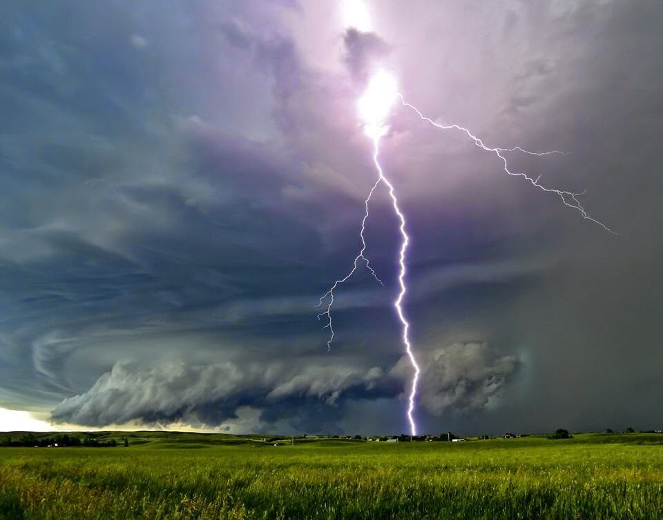
Lightning strikes on the sunset, what is more beautiful?
The electrical activity was intense during the #orages this October 4, with more than 18,000 #éclairs counted. Almost all in 3 departments: The #Var , the #HauteCorse and the #AlpesdeHauteProvence . All the data on our dedicated page ->https://keraunos.org/orages-en-dire
Quite the electrical storm in Southern California earlier in the week. Family member said their palm tree was struck and caught fire 
Approximately 4,000 lightning bolts were were reported over the past 24 hours, forecasters said Tuesday. About half that total was reported in Orange, San Diego and Riverside counties by 11 p.m. Monday.
The count also included dangerous cloud-to-ground lightning totals of 524 for San Diego County, 171 in Los Angeles County and 62 for Orange County, according to an NWS tally.
The lightning strikes were part of a raging storm that rolled into the Southland on Monday afternoon, bringing periods of heavy downpours, thunder, strong wind gusts and even hail well into the evening hours.
Yemen
Heavy torrential rains in Dis Mukalla, Hadhramaut coast. 10/6/2021
Heavy torrential rains in Dis Mukalla, Hadhramaut coast. 10/6/2021
Strong rain and electrical activity was presented today in the afternoon in Panama due to the passage of tropical waves No.40 and 41, abundant cloudiness, rains and significant storms with electrical activity are expected until next Tuesday, October 12, 2021.
Source:
A French photographer from Mosor captured sprites, a very rare and impressive meteorological phenomenon
According to the estimate of this photographer, the firefighters were at a distance of 329 to almost 500 kilometers. The latter were created above the storm cumulonimbus over the Italian region of Tuscany.A rare meteorological phenomenon, firemen, was photographed by the famous French photographer Stephane Vetter from the Zvjezdano selo Mosor observatory in the Gornje Sitno settlement in Split on the night of October 4-5.
In the space of a few hours, he filmed this light phenomenon from the terrace of the Mosor observatory, which was happening above the storm system over Italy, reports Dalmacija today .
According to the estimate of this photographer, the firefighters were at a distance of 329 to almost 500 kilometers . The latter were created above the storm cumulonimbus over the Italian region of Tuscany. The fire pit is formed at an altitude of about 70 kilometers as a short-lived light phenomenon in the form of fire flames directed downwards. The phenomenon can reach 90-100 kilometers in height, ie all the way to the ionosphere. It is a phenomenon of primarily red color , from the upper part of which branches like flames stand out, descending into the lower layers of the atmosphere, up to 25-30 kilometers into the stratosphere, and at the same time become bluish.

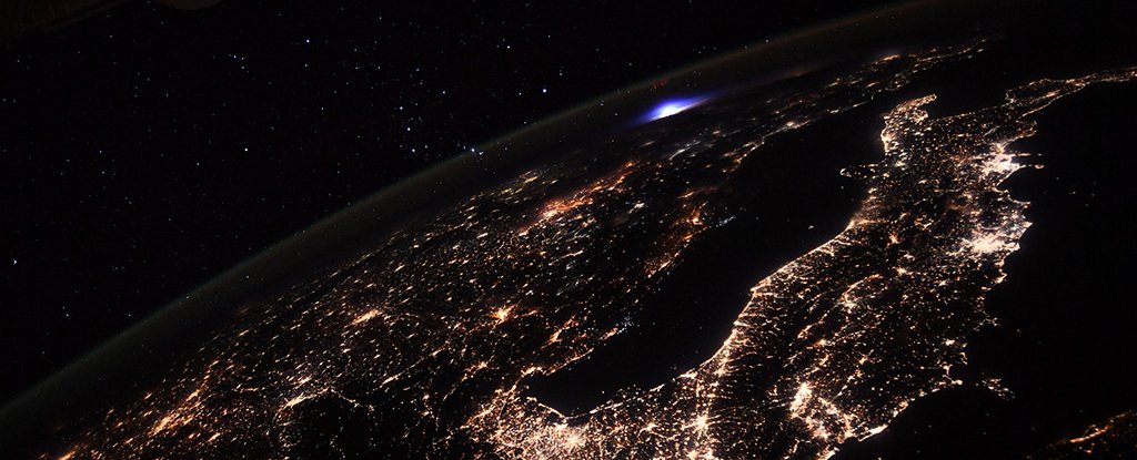
What The Heck Was This Blue 'Luminous Event' Photographed From The Space Station?
On October 8, French astronaut Thomas Pesquet captured something strikingly rare from on board the International Space Station (ISS).

What The Heck Was This Blue 'Luminous Event' Photographed From The Space Station?
11 OCTOBER 2021
On October 8, French astronaut Thomas Pesquet captured something strikingly rare from on board the International Space Station (ISS).
The photo – which is a single frame taken from a longer timelapse – might look like it shows a cobalt bomb exploding over Europe, but this scary-looking blue light didn't do any damage. In fact, most people would never have noticed it happening.
Instead, the frame shows something far less ominous called a 'transient luminous event' – a lightning-like phenomenon striking upwards in the upper atmosphere.
Also known as upper-atmospheric lightning, transient luminous events are a bunch of related phenomena which occur during thunderstorms, but significantly above where normal lightning would appear. While related to lightning, they work a little bit differently.
Torrential rains in Greece. The low pressure system named as Ballos, is leaving heavy rains and intense winds, causing numerous problems in much of the country. They report a deceased because of the strong storm.
Trending content
-
-
Thread 'Coronavirus Pandemic: Apocalypse Now! Or exaggerated scare story?'
- wanderingthomas
Replies: 30K -
-
