You are using an out of date browser. It may not display this or other websites correctly.
You should upgrade or use an alternative browser.
You should upgrade or use an alternative browser.
Earthquakes around the world
- Thread starter pescado
- Start date
Moderate earthquake, 5.6 mag has occurred near Izu Islands, Japan region
July 6, 2020

 sputniknews.com
06.07.2020
July 6, 2020
A moderate earthquake with magnitude 5.6 (ml/mb) was reported Izu Islands, Japan region (0 miles) on Monday. All ids that are associated to the event: us7000aiyp. Unique identifier: us7000aiyp. The earthquake occurred at a depth of 380.73 km (237 miles) below the earth’s surface. The temblor was reported at 18:19:09 / 6:19 pm (local time epicenter). A tsunami warning has not been issued (Does not indicate if a tsunami actually did or will exist). Exact time and date of earthquake 06/07/20 / 2020-07-06 18:19:09 / July 6, 2020 @ 6:19 pm UTC/GMT. Exact location, longitude 138.1515° East, latitude 31.477° North, depth = 380.73 km.
In the past 24 hours, there have been one, in the last 10 days one, in the past 30 days two and in the last 365 days nine earthquakes of magnitude 3.0 or greater that has occurred nearby. Each year there are an estimated 1320 moderate quakes in the world. Earthquakes 5.0 to 6.0 may cause light damage to buildings and other structures.

Magnitude 6.6 Earthquake Strikes Off Indonesia - USGS
The epicentre of the quake was 93 kilometres north of Batang, in the province of Java, at a depth of more than 500 kilometres, seismologists say.

5.1 magnitude earthquake strikes off coast of Alaska
There is no information on injuries as a result of the earthquake, and no tsunami threat has been announced
Chad
The Living Force
According to USGS there's just been a M4.9 earthquake, 10km deep, in Lubin, Poland.
Notably there were a few M2s registered in the weeks prior that kept appearing on the quake alert acccount i follow, and so i did a little looking and although it did seem like they had increased in frequency, it wasn't clear whether this was that unusual.
While there's probably a number of related quakes that occurred before, one that also comes to mind was a M4.2 near Blagaj, Bosnia Herzegovina on 7th July.
Added: whilst looking into Poland's seismic activity yesterday i came across this detailing quakes recorded in the past:
Affected countries: Czechia, Germany, Poland, and Slovakia
11 km from Lubin, Poland · 07:19

Notably there were a few M2s registered in the weeks prior that kept appearing on the quake alert acccount i follow, and so i did a little looking and although it did seem like they had increased in frequency, it wasn't clear whether this was that unusual.
While there's probably a number of related quakes that occurred before, one that also comes to mind was a M4.2 near Blagaj, Bosnia Herzegovina on 7th July.
Added: whilst looking into Poland's seismic activity yesterday i came across this detailing quakes recorded in the past:
Poland is a country of low seismic activity and return periods of earthquakes are long. Thus, historical records of seismic events are here the main source of information. Earthquake catalogue since XVI century, without foreshocks and aftershocks, is listed. Epicenters of seismic events are distributed mainly in southern Poland along Sudetes and Carpathians, and in central and northwestern Poland, generally along the Teisseyre-Tornquist Zone. The historical data from the Precambrian Platform in northeastern Poland, and from the Fore-Sudetic Block and the Carpathian Foredeep are too poor for evaluation of earthquake parameters with sufficient accuracy. The Orawa-Nowy Targ Basin in the Carpathians is the best seismically recognized region in Poland. A series of seismic events occurred on November 30, 2004, with the main earthquake of magnitude M = 4.4 and epicentral intensity I 0 = 7 in the EMS-98 scale, caused even damage to buildings. Similar events were recorded there in years 1935 and 1717. The Kaliningrad earthquakes of M = 5.0 and M = 5.2 on September 21, 2004 occurred in the area of the Precambrian Platform supposed to be aseismic. The earthquakes caused slight damage to individual buildings in more than 100 localities in northern and northeastern Poland. The seismicity of Poland can be only well recognized by monitoring of micro shocks, i. e. seismic events of M ≪ 2 by arrays of local seismic stations located both in active and supposedly aseismic areas.
Last edited:
5.6-magnitude quake hits western Indian-Antarctic Ridge -- USGS
2020-07-08
2020-07-08
HONG KONG, July 8 (Xinhua) -- An earthquake with a magnitude of 5.6 jolted western Indian-Antarctic Ridge at 09:08:24 GMT on Wednesday, the U.S. Geological Survey said.
The epicenter, with a depth of 10.0 km, was initially determined to be at 49.7963 degrees south latitude and 114.3173 degrees east longitude.
The biggest earthquake worldwide last week was a M6.6 in Indonesia.This last week saw 3 out of 83 earthquakes of those equal or above to 4.5 in the map area (today looking slightly different as I am on the road). There were no M6 or above worldwide this last week. 2563 out of 3040 out of all earthquakes worldwide (according to USGS only) also fell in the area.
Percentage 84,3%
The usual area considered in this weekly reporting saw 4 out of 80 earthquakes equal or greater to 4.5 and 2694 of 2985 quakes of all sizes.
Percentage: 90.3%

5.1-magnitude quake hits city in north China
A 5.1-magnitude earthquake jolts a district in Tangshan City, in north China
BREAKING:

 sputniknews.com

Magnitude 5.1 Earthquake Registered in Venezuela, USGS Reports
The seismic activity was recorded at a depth of 10 kilometres. There are no reports of damage or casualties caused by the tremor.
5.7-magnitude quake hits 151 km north of Ruteng, Indonesia -- USGS
2020-07-15
2020-07-15
NEW YORK, July 14 (Xinhua) -- An earthquake with a magnitude of 5.7 jolted 151 km north of Ruteng, Indonesia at 23:33:58 GMT on Tuesday, the U.S. Geological Survey said.
The epicenter, with a depth of 599.13 km, was initially determined to be at 7.2439 degrees south latitude and 120.4496 degrees east longitude.
5.8-magnitude quake hits 70 km WSW of Rio Grande, Panama -- USGS
July 16, 2020
July 16, 2020
NEW YORK, July 15 (Xinhua) -- A 5.8-magnitude earthquake jolted 70 km WSW of Rio Grande, Panama at 21:39:40 GMT on Wednesday, the U.S. Geological Survey said.
The epicenter, with a depth of 5.66 km, was initially determined to be at 7.4708 degrees north latitude and 81.922 degrees west longitude.

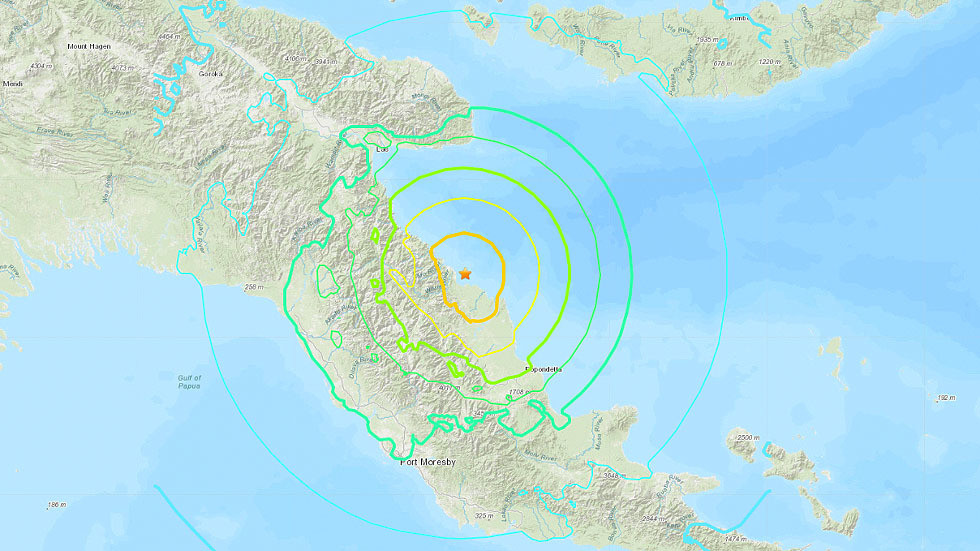
7.0-magnitude quake hits off Papua New Guinea coast
A 7.0-magnitude earthquake has struck the region of eastern Papua New Guinea at a depth of 85.5km, the US Geological Survey reported. A tsunami warning was issued.
Agron
Jedi Council Member
M 5.9 - South-America Chile [Antofagasta] Tocopilla
Preliminary Earthquake Report:
Date/Time: 17.07.2020 05:40:36 UTC
Magnitude: M 5.9
Mercalli Scale: 6
Depth: 73.82 km
Coordinate: 20° 14.118, 70° 8.394
Additional data:
Local time in the epicenter: Friday, July 17, 2020 at 01:40 at night at epicenter
Continent: South-America
Country: Chile [CL]
State: [Antofagasta]
Location: 70.00 km (43.50 miles) W of Tocopilla, [Antofagasta]
Population: 24460 person(s)
6.1-magnitude quake hits 236 km E of Port Blair, India -- USGS
2020-07-17
2020-07-17
HONG KONG, July 17 (Xinhua) -- An earthquake with a magnitude of 6.1 jolted 236 km E of Port Blair, India at 14:03:42 GMT on Friday, the U.S. Geological Survey said.
The epicenter, with a depth of 10.0 km, was initially determined to be at 11.984 degrees north latitude and 94.8885 degrees east longitude.
5.7-magnitude quake hits 243 km E of Port Blair, India -- USGS
2020-07-18
 July 18, 2020
2020-07-18
NEW YORK, July 17 (Xinhua) -- An earthquake with a magnitude of 5.7 jolted 243 km E of Port Blair, India at 18:32:59 GMT on Friday, the U.S. Geological Survey said.
The epicenter, with a depth of 10.13 km, was initially determined to be at 12.0932 degrees north latitude and 94.9395 degrees east longitude.

Moderate earthquake, 5.9 mag was detected near Kirakira in Solomon Islands
A moderate earthquake magnitude 5.9 (ml/mb) strikes near Kirakira, Solomon Islands on Saturday. The temblor has occurred at 01:37:14/1:37 am (UTC/GMT) at a depth of 42.42 km (26 miles). How did you react? Was there any damage?
www.earthquakenewstoday.com
M 6.1 - 144 km ENE of Hihifo, Tonga
2020-07-18
2020-07-18
Trending content
-
Thread 'Coronavirus Pandemic: Apocalypse Now! Or exaggerated scare story?'
- wanderingthomas
Replies: 30K -
-
-
