WORLDWIDE EARTHQUAKE REPORT FEBRUARY 02/2023
Another strong earthquake in the Caribbean plate

● M 5.0 - 49 km NNE of Beauséjour, Guadeloupe
2023-02-02 13:13:23 (UTC)
16.727°N 60.935°W. 23.7 km depth
USGS earthquake alert
Guadeloupe was shaken 49 km (31 mi) NNE of Beauséjour (pop: 1,720) Guadeloupe, by an earthquake of magnitude 5.0 The quake hit at a shallow depth of 23.7 km beneath the epicenter near Abymes, Guadeloupe, in the morning on Thursday, February 2nd, 2023, at 9:13 am local time. Soufrière de Guadeloupe is the nearest volcano located at 109 km its current status is restless

● M 5.0 - 58 km W of Tyonek, Alaska
2023-02-02 14:48:25 (UTC)
61.072°N 152.214°W. 111.0 km depth
USGS earthquake alert
A magnitude 5.0 earthquake 58 km (36 mi) W of Tyonek (pop: 171) The earthquake occurred at an intermediate depth of 111 km beneath the epicenter early morning on Thursday, February 2nd, 2023, at 5:48 am local time. Spurr is the nearest volcano located at 25 km from epicenter. Mount Spurr is a stratovolcano and is the highest volcano in the Aleutian Volcanic Arc. According to Volcanodiscovery "Mt Spurr had a violent sub-plinian eruption in 1992 and a large eruption in 1953, both ranking at VEI 4 and produced by Crater Peak, a small flank vent on the south side."

● M 5.0 - 84 km NNE of Tobelo, Indonesia
2023-02-02 23:05:07 (UTC)
2.460°N 128.224°E. 88.2 km depth
USGS earthquake alert
An earthquake of magnitude 5.0 occurred 100 km north of Tobelo (pop. 10,000) Indonesia, Indonesia's Meteorology, Climatology, and Geophysical Agency reported. The quake hit at an intermediate depth of 88 km beneath the epicenter near Tobelo, in the morning on Friday, February 3rd, 2023, at 8:05 am local time.

● Earthquake Forecast: Larger seismic activity may occur from 4 to 6 February, most likely up to mid or high 6 magnitude. There is a slight possibility of a larger seismic event around 4 February.
Solar System Geometry Survey
● Summary
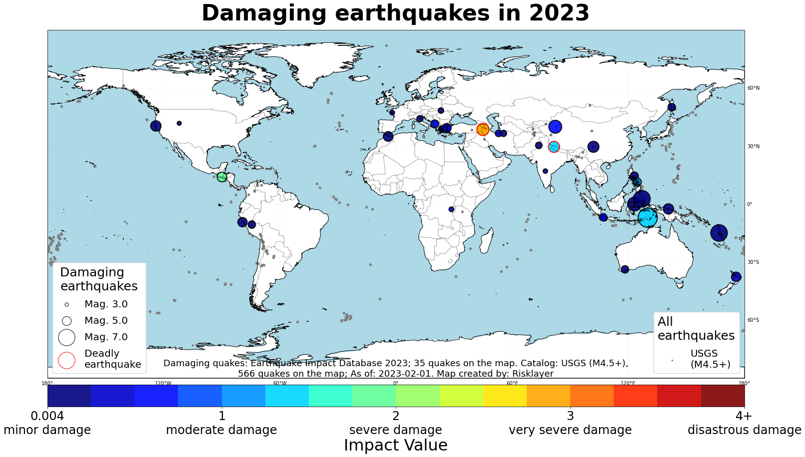
Seismic activity level has been at low levels in the last 24 hours. This is the last chart posted by Volcanodiscovery at 00:30 UTC on February 02 Global seismic activity chart
~3 quakes above magnitude 5
~39 quakes between magnitude 4 and 5
~87 quakes between magnitude 3 and 4
~217 quakes between magnitude 2 and 3
~499 quakes below magnitude 2 that people normally don't feel.
~845 earthquakes in the past 24h (835 earthquakes in the 24 hours prior to this report) Estimated combined seismic energy release: 4128 tons of TNT or 0.3 atomic bombs
Volcanodiscovery earthquake report 24h
Another strong earthquake in the Caribbean plate
● M 5.0 - 49 km NNE of Beauséjour, Guadeloupe
2023-02-02 13:13:23 (UTC)
16.727°N 60.935°W. 23.7 km depth
USGS earthquake alert
Guadeloupe was shaken 49 km (31 mi) NNE of Beauséjour (pop: 1,720) Guadeloupe, by an earthquake of magnitude 5.0 The quake hit at a shallow depth of 23.7 km beneath the epicenter near Abymes, Guadeloupe, in the morning on Thursday, February 2nd, 2023, at 9:13 am local time. Soufrière de Guadeloupe is the nearest volcano located at 109 km its current status is restless
● M 5.0 - 58 km W of Tyonek, Alaska
2023-02-02 14:48:25 (UTC)
61.072°N 152.214°W. 111.0 km depth
USGS earthquake alert
A magnitude 5.0 earthquake 58 km (36 mi) W of Tyonek (pop: 171) The earthquake occurred at an intermediate depth of 111 km beneath the epicenter early morning on Thursday, February 2nd, 2023, at 5:48 am local time. Spurr is the nearest volcano located at 25 km from epicenter. Mount Spurr is a stratovolcano and is the highest volcano in the Aleutian Volcanic Arc. According to Volcanodiscovery "Mt Spurr had a violent sub-plinian eruption in 1992 and a large eruption in 1953, both ranking at VEI 4 and produced by Crater Peak, a small flank vent on the south side."
● M 5.0 - 84 km NNE of Tobelo, Indonesia
2023-02-02 23:05:07 (UTC)
2.460°N 128.224°E. 88.2 km depth
USGS earthquake alert
An earthquake of magnitude 5.0 occurred 100 km north of Tobelo (pop. 10,000) Indonesia, Indonesia's Meteorology, Climatology, and Geophysical Agency reported. The quake hit at an intermediate depth of 88 km beneath the epicenter near Tobelo, in the morning on Friday, February 3rd, 2023, at 8:05 am local time.
● Earthquake Forecast: Larger seismic activity may occur from 4 to 6 February, most likely up to mid or high 6 magnitude. There is a slight possibility of a larger seismic event around 4 February.
MAGNITUDE PROBABILITY
updated 2 February 2023, 09:49 UTC| M 6.0-6.4 | M 6.5-6.9 | M 7.0-8.4 | M 8.5+ |
| 50% | 40% | 40% | 30% |
● Summary
Seismic activity level has been at low levels in the last 24 hours. This is the last chart posted by Volcanodiscovery at 00:30 UTC on February 02 Global seismic activity chart
~3 quakes above magnitude 5
~39 quakes between magnitude 4 and 5
~87 quakes between magnitude 3 and 4
~217 quakes between magnitude 2 and 3
~499 quakes below magnitude 2 that people normally don't feel.
~845 earthquakes in the past 24h (835 earthquakes in the 24 hours prior to this report) Estimated combined seismic energy release: 4128 tons of TNT or 0.3 atomic bombs
Volcanodiscovery earthquake report 24h