Earthquakes around the world

WORLDWIDE EARTHQUAKE REPORT FEBRUARY 15/2023

● M 5.2 - 193 km WSW of Adak, Alaska
2023-02-15 07:35:23 (UTC)
51.253°N 179.239°W. 35.0 km depth
USGS earthquake alert
Moderate magnitude 5.2 earthquake in Bering Sea, 120 mi west of Adak (pop. 332), Aleutians West, Alaska, USA, on Tuesday, Feb 14, 2023 at 9:35 pm local time

●M 5.1 - 101 km E of Neiafu, Tonga
2023-02-15 18:00:55 (UTC)
18.527°S 173.033°W. 30.5 km depth
USGS earthquake alert

Two magnitude 5.1 earthquakes occur within a minute of each other on the Mid-Atlantic Ridge.

●M 5.1 - central Mid-Atlantic Ridge
2023-02-15 02:13:12 (UTC)
8.016°N 37.068°W. 10.0 km depth
USGS earthquake alert

●M 5.1 - central Mid-Atlantic Ridge
2023-02-15 02:14:32 (UTC)
7.883°N 36.988°W. 10.0 km depth
USGS earthquake alert

●M 5.0 - 122 km WNW of Colchani, Bolivia
2023-02-15 22:12:20 (UTC)
20.046°S 68.076°W. 173.9 km depth
USGS earthquake alert
A magnitude 5.0 earthquake 122 km (76 mi) WNW of Colchani (Potosí) (pop: 12,000) Bolivia. The earthquake occurred at an intermediate to considerable depth of 174 km beneath the epicenter early evening on Wednesday, February 15th, 2023, at 6:12 pm local time.

●M 4.8 - 12 km SE of Pāhala, Hawaii
2023-02-15 07:27:06 (UTC)
19.114°N 155.407°W. 31.8 km depth
USGS earthquake alert
Moderate magnitude 4.8 earthquake - North Pacific Ocean, 47 mi southwest of Hilo, Hawaii County, USA, on Tuesday, Feb 14, 2023 at 9:27 pm local time. Loihi is a submarine volcano nearest located at 26 km from epicenter.

● Strongest aftershock today in Turkey

M 4.6 - 1 km WSW of Göksun, Turkey
2023-02-15 07:36:30 (UTC)
38.014°N 36.480°E. 10.0 km depth
USGS earthquake alert

The kilometer-long geological fractures in kahramanmaras left by past earthquakes in Turkey.

● Summary

Seismic activity level has been at high levels in the last 24 hours. This is the last chart posted by Volcanodiscovery at 01:00 UTC on February 15 Global seismic activity chart
~2 quakes above magnitude 6
~6 quakes between magnitude 5 and 6
~32 quakes between magnitude 4 and 5
~175 quakes between magnitude 3 and 4
~440 quakes between magnitude 2 and 3
~541 quakes below magnitude 2 that people normally don't feel.
~1196 earthquakes in the past 24h (1100 earthquakes in the 24 hours prior to this report) Estimated combined seismic energy release: 71155 tons of TNT or 4.4 atomic bombs
Volcanodiscovery earthquake report 24h
 
WORLDWIDE EARTHQUAKE REPORT FEBRUARY 16/2023

Strong earthquake rocks Haiti and Cuba

●M 5.4 - 42 km WSW of Bombardopolis, Haiti
2023-02-16 06:50:46 (UTC)
19.610°N 73.738°W. 14.2 km depth
USGS earthquake alert

The U.S. Geological Survey recorded a strong earthquake of magnitude 5.4 in northern Haiti early Thursday morning at 01:50 local time.

The epicenter of the quake was 42 km from Bombardopolis, Haiti and 79.3 km southeast of Maisí (pop. 27300) Guantánamo province, Cuba, with a depth of 14.2 kilometers.


●M 5.6 - Vanuatu
2023-02-16 05:37:05 (UTC)
15.091°S 167.029°E. 36.0 km depth
USGS earthquake alert

●M 5.3 - southern Mid-Atlantic Ridge
2023-02-16 15:55:33 (UTC)
21.884°S 11.631°W. 10.0 km depth
USGS earthquake alert

●M 5.2 - 19 km WNW of Uzunbağ, Turkey
2023-02-16 19:47:49 (UTC)
36.201°N 35.828°E. 10.0 km depth
USGS earthquake alert
Aftershock greater than magnitude 5.0 shook Turkey 30 km west of Antioch, Antakya İlçesi, Hatay, on Thursday, Feb 16, 2023 at 9:47 pm local time


●M 5.1 - 95 km SSW of Puerto San José, Guatemala
2023-02-16 12:02:40 (UTC)
13.190°N 91.284°W. 10.0 km depth
USGS earthquake alert

●M 5.0 - 27 km W of San Nicolas, Philippines
2023-02-16 10:33:58 (UTC)
14.980°N 119.825°E. 52.4 km depth
USGS earthquake alert

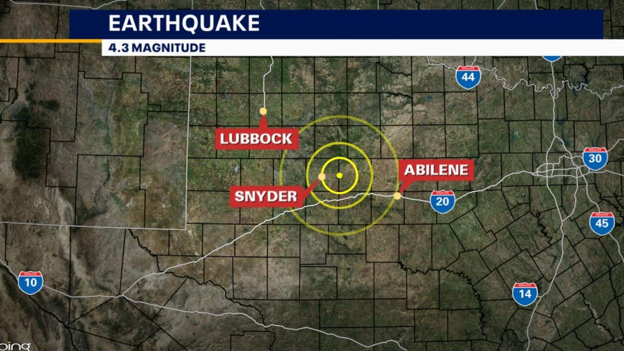
●M 4.7 - 15 km NE of Hermleigh, Texas
2023-02-16 10:29:04 (UTC)
32.745°N 100.652°W. 8.7 km depth
USGS earthquake alert

M 4.1 - 72 km WSW of Palmar de Cuautla, Mexico
2023-02-16 05:38:02 (UTC)
22.067°N 106.333°W. 15.0 km depth
USGS earthquake alert

● Summary

Seismic activity level has been at moderate levels in the last 24 hours. This is the last chart posted by Volcanodiscovery at 01:00 UTC on February 17 Global seismic activity chart
~7 quakes above magnitude 5
~41 quakes between magnitude 4 and 5
~153 quakes between magnitude 3 and 4
~498 quakes between magnitude 2 and 3
~616 quakes below magnitude 2 that people normally don't feel.
~1315 earthquakes in the past 24h (1196 earthquakes in the 24 hours prior to this report) Estimated combined seismic energy release: 71155 tons of TNT or 4.4 atomic bombs: 14447 tons of TNT or 0.9 atomic bombs
Volcanodiscovery earthquake report 24h
 

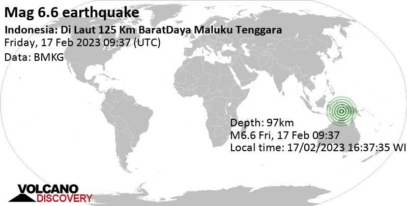
Strong mag. 6.6 earthquake - Banda Sea, 130 km southwest of Tual, Maluku, Indonesia

Date & timeFeb 17, 2023 09:37:35 UTC - 2 hours 16 minutes ago
Local time at epicenterFriday, Feb 17, 2023 at 7:07 pm (GMT +9:30)
StatusConfirmed
Magnitude6.6
Depth97.0 km
Epicenter latitude / longitude6.6°S / 132.1°E
ID.png
(Banda Sea, Indonesia)
Antipode6.6°N / 47.9°W
Shaking intensityWeak shaking
Felt156 reports
Primary data sourceBMKG (Meteorological, Climatological, and Geophysical Agency of Indonesia)
Nearest volcanoManuk (233 km / 145 mi)
 
Moderate mag. 4.5 earthquake - 17 km west of Târgu Jiu, Gorj, Romania, on Friday, Feb 17, 2023 at 11:11 am. This quake was likely an aftershock of the 5.6 quake 10.8 km northwest of Târgu Jiu, Gorj, Romania, Feb 14, 2023

Twenty-one aftershocks greater than magnitude 3 have been recorded in Târgu Jiu Gorj since February 14 and this M4.5 earthquake has been the highest magnitude.

M 4.5 - Romania
2023-02-17 09:11:40 (UTC)
45.086°N 23.068°E. 10.0 km depth
USGS earthquake alert
chrome_screenshot_1676646773804.png

Agencies updated the earthquake M6.6 to M6.1

M 6.1 - 130 km SW of Tual, Indonesia
2023-02-17 09:37:34 (UTC)6.599°S 132.076°E38.6 km depth
USGS earthquake alert

Data for the same earthquake reported by different agencies

Mag.DepthLocationSource
6.697 kmIndonesia: Di Laut 125 Km BaratDaya Maluku TenggaraBMKG
6.110 kmKEP. TANIMBAR REGION, INDONESIAEMSC
6.139 kmTanimbar Islands Reg., IndonesiaRaspberry
Shake
6.110 kmTanimbar Islands Reg., IndonesiaGeoAu
6.110 kmIndonesia: Near AmbonRENASS
6.020 kmIndonesia [Sea]INGV
6.146 km130 Km SW of Tual, IndonesiaGFZ
6.139 kmTanimbar Islands Region, IndonesiaUSGS
6.110 kmTanimbar Islands Reg., IndonesiaIRIS
 
WORLDWIDE EARTHQUAKE REPORT FEBRUARY 18/2023

● M 5.2 - 82 km E of Nago, Japan
2023-02-17 01:46:31 (UTC)
26.474°N 128.799°E. 13.3 km depth
USGS earthquake alert
An earthquake of magnitude 5.2 occurred in the morning on Friday, February 17th, 2023, at 10:46 am local time 82 km (51 mi) E of Naga (pop: 59,600) Okinawa, Japan. According to USGS data, the quake was located at a shallow depth of 13 km. Shallow earthquakes are felt more strongly than deeper ones as they are closer to the surface.

● M 5.3 - central Mid-Atlantic Ridge
2023-02-17 02:11:31 (UTC)
1.079°N 28.081°W. 10.0 km depth
USGS earthquake alert

● M 4.5 - 23 km SW of Kovancılar, Turkey
2023-02-17 15:34:38 (UTC)
38.584°N 39.648°E. 10.0 km depth
USGS earthquake alert
Strongest aftershock in Turkey today.

● Electromagnetic fluctuation detected in the purple band across Pacific Ocean. We also have to consider this afternoon's X2.3 solar flare whose radiation ionized the upper part of the Earth's atmosphere over the west coast of the American continent and the Pacific Ocean.

Since the earthquake in Turkey we have exceeded 1100 earthquakes per day.

● Summary

Seismic activity level has been at high levels in the last 24 hours. This is the last chart posted by Volcanodiscovery at 00:40 UTC on February 18 Global seismic activity chart
~1 quake above magnitude 6
~2 quakes between magnitude 5 and 6
~43 quakes between magnitude 4 and 5
~125 quakes between magnitude 3 and 4
~447 quakes between magnitude 2 and 3
~644 quakes below magnitude 2 that people normally don't feel.
~1262 earthquakes in the past 24h (1315 earthquakes in the 24 hours prior to this report) Estimated combined seismic energy release: 146 gigawatt hours, equivalent to 1.3 x 10⁵ tons of TNT or 7.9 atomic bombs
Volcanodiscovery earthquake report 24h
 
Strong earthquake rocks Costa Rica

M 5.2 - 11 km ESE of Río Segundo, Costa Rica
2023-02-18 08:24:12 (UTC)
10.220°N 84.176°W. 10.0 km depth
USGS earthquake alert
Costa Rica was shaken 33 km San Jose (pop: 335,000) Provincia de San José and 12 km (7 mi) E of Rio Segundo (Valverde Vega, Alajuela) (pop: 9,850) by an earthquake of magnitude 5.2
The quake hit at a shallow depth of 10 km beneath the epicenter near San Jose early morning on Saturday, February 18th, 2023, at 2:24 am local time. Poas volcano is located 7 km from epicenter and is one of Costa Rica´s most active volcanoes. Poas last eruption was in 2017
20230218_091336.png

The Caribbean plate has been active in the last few months.

M 6.2 - 40 km WSW of Pointe-Noire, Guadeloupe
2023-01-20 11:23:41 (UTC)
16.131°N 62.156°W. 166.4 km depth
USGS earthquake alert
M 5.0 - 32 km SSE of Matanzas, Dominican Republic
2023-02-01 11:11:16 (UTC)
17.953°N 70.353°W. 45.1 km depth
USGS earthquake alert
● M 5.0 - 49 km NNE of Beauséjour, Guadeloupe
2023-02-02 13:13:23 (UTC)
16.727°N 60.935°W. 23.7 km depth
USGS earthquake alert
Strong earthquake rocks Haiti and Cuba

●M 5.4 - 42 km WSW of Bombardopolis, Haiti
2023-02-16 06:50:46 (UTC)
19.610°N 73.738°W. 14.2 km depth
USGS earthquake alert

placa-del-caribe.jpg
 
WORLDWIDE EARTHQUAKE REPORT FEBRUARY 18/2023

● M 5.7 - South Sandwich Islands region
2023-02-18 21:28:00 (UTC)
55.433°S 27.888°W. 20.4 km depth
USGS earthquake alert

● M 5.4 - 218 km ENE of Levuka, Fiji
2023-02-18 23:03:05 (UTC)
17.534°S 178.699°W. 548.3 km depth
USGS earthquake alert

● M 5.3 - 85 km NNW of Sola, Vanuatu
2023-02-18 09:02:54 (UTC)
13.228°S 167.119°E. 198.6 km depth
USGS earthquake alert

● M 5.0 - 9 km ENE of Göksun, Turkey
2023-02-18 19:31:31 (UTC)
38.051°N 36.600°E. 10.1 km depth
USGS earthquake alert

● M 4.7 - Crete, Greece
2023-02-18 17:32:57 (UTC)
35.830°N 25.516°E. 10.0 km depth
USGS earthquake alert


● Summary

Seismic activity level has been at moderate levels in the last 24 hours. This is the last chart posted by Volcanodiscovery at 00:40 UTC on February 19 Global seismic activity chart
~5 quakes above magnitude 5
~51 quakes between magnitude 4 and 5
~146 quakes between magnitude 3 and 4
~418 quakes between magnitude 2 and 3
~503 quakes below magnitude 2 that people normally don't feel.
~1123 earthquakes in the past 24h (1262 earthquakes in the 24 hours prior to this report) Estimated combined seismic energy release: 14674 tons of TNT or 0.9 atomic bombs.
Volcanodiscovery earthquake report 24h
 
This week saw a lot of activity, with 2 M7 (M7.8 and M7.5) and 3 M6. All of them in Turkey.
In the usual area, there were 0 out of 182 earthquakes worldwide equal to or greater than 4.5 and 1551 out of 2015 quakes of all sizes.
Percentage: 76.9%
This week saw 6 M6 earthquakes, all M6.1 and in New Zealand, Indonesia and the Philippines.
In the usual area, there were 3 out of 111 earthquakes worldwide equal to or greater than 4.5 and 1552 out of 1893 quakes of all sizes.
Percentage: 82.0%
Earthquakes 7 days to Feb 19th  2023.gif
 
WORLDWIDE EARTHQUAKE REPORT FEBRUARY 20/2023

In his latest video SSGEOS forecast for the coming days a clustering of earthquakes. In the past 24 hours around the Ring of Fire most of the activity above magnitude 4 has been recorded, although this activity is not unusual throughout the region (Chile, Indonesia, Japan) Outside the ring of fire we find that the Caribbean plate has been active and this is mainly concentrated in the Puerto Rico region. While in the eastern Mediterranean region Turkey continues to record activity above magnitude 4, a magnitude 4.5 earthquake was recorded in Italy and a magnitude 4.5 in Cyprus.

● M 5.3 - 109 km WNW of Iquique, Chile
2023-02-19 02:40:40 (UTC)
19.967°S 71.167°W. 7.2 km depth
USGS earthquake alert
20230219_200836.jpg

● M 5.0 - 162 km NE of Laikit, Laikit II (Dimembe), Indonesia
2023-02-19 15:17:04 (UTC)
2.427°N 126.096°E. 76.7 km depth
USGS earthquake alert

● M 5.0 - Hokkaido, Japan region
2023-02-19 18:55:42 (UTC)
42.798°N 143.131°E. 130.4 km depth
USGS earthquake alert

● M 5.3 - South Pacific Ocean
2023-02-19 23:23:36 (UTC)
34.358°S 126.162°W. 10.0 km depth
USGS earthquake alert

● M 5.3 - Mid-Indian Ridge
2023-02-19 16:07:11 (UTC)
12.820°S 66.371°E. 10.0 km depth
USGS earthquake alert

● M 5.0 - South Sandwich Islands region
2023-02-19 13:08:13 (UTC)
58.414°S 23.199°W. 10.0 km depth
USGS earthquake alert

● M 4.5 - 59 km WNW of Leni, Italy
2023-02-20 01:11:16 (UTC)
38.674°N 14.156°E. 10.0 km depth
USGS earthquake alert

● M 3.6 - 6 km SSW of Limassol, Cyprus
2023-02-19 14:26:20 (UTC)
34.628°N 33.005°E. 3.6 km depth
USGS earthquake alert
chrome_screenshot_1676858597829.png

● Earthquake Forecast: updated 19 February 2023, 13:31 UTC. Stronger (clustering of) seismic activity may occur from approximately 20 to 22 February, potentially peaking around the 22nd. SSGEOS

MAGNITUDE PROBABILITY

updated 19 February 2023, 13:31 UTC

M 6.0-6.4M 6.5-6.9M 7.0-8.4M 8.5+
50%50%50%40%


● Summary

Seismic activity level has been at moderate levels in the last 24 hours. This is the last chart posted by Volcanodiscovery at 01:40 UTC on February 20 Global seismic activity chart
~8 quakes above magnitude 5
~49 quakes between magnitude 4 and 5
~145 quakes between magnitude 3 and 4
~420 quakes between magnitude 2 and 3
~484 quakes below magnitude 2 that people normally don't feel.
~1106 earthquakes in the past 24h (1123 earthquakes in the 24 hours prior to this report) Estimated combined seismic energy release: 12051 tons of TNT or 0.8 atomic bombs
Volcanodiscovery earthquake report 24h
 
Very Strong Earthquake Turkey

M 6.3 - 3 km SW of Uzunbağ, Turkey
2023-02-20 17:04:28 (UTC)
36.121°N 36.004°E
10.0 km depth
USGS earthquake alert

Data for the same earthquake reported by different agencies

Mag.DepthLocationSource
6.410 km3 Km WSW of Uzunbağ, TurkeyUSGS
6.22 kmTURKEY-SYRIA BORDER REGIONEMSC
6.410 kmTurkey: 588 Km E From Megisti (Kastellorizo)NOA
6.210 kmTurkeyGFZ
 
Very Strong Earthquake Turkey

I was just reading reports from family and friends in Cyprus that they felt a strong earthquake in the capital, Nicosia, and it was from the new Turkey quake.

These poor people in the affected areas!

Earthquake registering 6.3 hits Turkey-Syria border region -EMSC


ANTAKYA, Feb 20 (Reuters) - An earthquake, with a magnitude 6.3 at a depth of two km (1.2 miles), struck the Turkey-Syria border region on Monday, the European Mediterranean Seismological Centre (EMSC) said.

Two Reuters witnesses reported a strong quake and further damage to buildings in central Antakya which was hit by two massive earthquakes two weeks ago, causing tens of thousands of deaths and destroying buildings and infrastructure.

Other witnesses said Turkish rescue teams were running around after the latest quake, checking people were unharmed.

Muna Al Omar, a resident, said she was in a tent in a park in central Antakya when the earthquake hit.

"I thought the earth was going to split open under my feet," she said, crying as she held her 7-year-old son in her arms.

"Is there going to be another aftershock?" she asked.
 
WORLDWIDE EARTHQUAKE REPORT FEBRUARY 20/2023

According to Volcanodiscovery data the M6.3 (17:04 UTC feb 20) earthquake in Turkey released a estimated energy of 42502 tons of TNT or 2.7 atomic bombs. This quake was likely an aftershock of the 7.8 quake 32 km west of Gaziantep, Turkey on Feb 6, 2023. Several earthquakes have been recorded after the M6.3 earthquake and the highest magnitudes have been M4.2 and M4.3.

●M 4.2 - 9 km SSW of Uzunbağ, Turkey
2023-02-20 19:00:14 (UTC)
36.067°N 35.986°E. 10.0 km depth
USGS earthquake alert

●M 4.3 - 7 km NW of Nurhak, Turkey
2023-02-20 23:21:14 (UTC)
38.008°N 37.372°E. 10.0 km depth
USGS earthquake alert

The earthquake was felt in countries such as Lebanon, Jordan, Iraq, Syria and Egypt. The sea was seen to be completely withdrawn in the city of Akka, Israel.

Sea reported to have receded off #Akka coast near #Hayfa Bay in #Palestine following new earthquake recorded southeast of Turkey.

● M 5.0 - 73 km NE of Casuguran, Philippines
2023-02-20 03:09:47 (UTC)15.213°N 122.829°E10.0 km depth
USGS earthquake alert

● M 5.1 - 142 km SSE of ‘Ohonua, Tonga
2023-02-20 04:05:03 (UTC)
22.456°S 174.276°W. 10.0 km depth
USGS earthquake alert

● M 5.1 - Solomon Islands
2023-02-20 17:53:33 (UTC)
9.829°S 160.237°E. 12.0 km depth
USGS earthquake alert

● Summary

Seismic activity level has been at moderate levels in the last 24 hours. This is the last chart posted by Volcanodiscovery at 01:00 UTC on February 21 Global seismic activity chart
~1 quake above magnitude 6
~3 quakes between magnitude 5 and 6
~50 quakes between magnitude 4 and 5
~154 quakes between magnitude 3 and 4
~447 quakes between magnitude 2 and 3
~576 quakes below magnitude 2 that people normally don't feel.
~1231 earthquakes in the past 24h (1106 earthquakes in the 24 hours prior to this report) Estimated combined seismic energy release: 47938 tons of TNT or 3 atomic bombs
Volcanodiscovery earthquake report 24h
 

Trending content

Back
Top Bottom