Earthquakes around the world

WORLDWIDE EARTHQUAKE REPORT FEBRUARY 21/2023

● M 5.4 - 42 km SSE of Old Harbor, Alaska
2023-02-21 05:35:23 (UTC)
56.845°N 153.074°W. 9.2 km depth
USGS earthquake alert

● M 5.1 - 110 km SSE of Akureyri, Iceland
2023-02-21 08:41:04 (UTC) 64.715°N 17.576°W. 10.0 km depth
USGS earthquake alert

● M 5.1 - Bonin Islands, Japan region
2023-02-21 18:05:33 (UTC)
27.128°N 143.557°E. 11.9 km depth
USGS earthquake alert

● M 5.0 - South Sandwich Islands region
2023-02-21 02:54:01 (UTC)
59.359°S 24.066°W. 10.0 km depth
USGS earthquake alert

● M 5.0 - Banda Sea
2023-02-21 16:15:52 (UTC)
6.227°S 130.104°E. 10.5 km depth
USGS earthquake alert

● M 5.0 - 282 km WSW of Sinabang, Indonesia
2023-02-21 19:22:12 (UTC)
1.819°N 93.923°E. 10.0 km depth
USGS earthquake alert

● Summary

Seismic activity level has been at moderate levels in the last 24 hours. This is the last chart posted by Volcanodiscovery at 00:00 UTC on February 22 Global seismic activity chart
~6 quakes above magnitude 5
~24 quakes between magnitude 4 and 5
~152 quakes between magnitude 3 and 4
~497 quakes between magnitude 2 and 3
~694 quakes below magnitude 2 that people normally don't feel.
~1373 earthquakes in the past 24h (1231 earthquakes in the 24 hours prior to this report) Estimated combined seismic energy release: 7718 tons of TNT or 0.5 atomic bombs
Volcanodiscovery earthquake report 24h
 
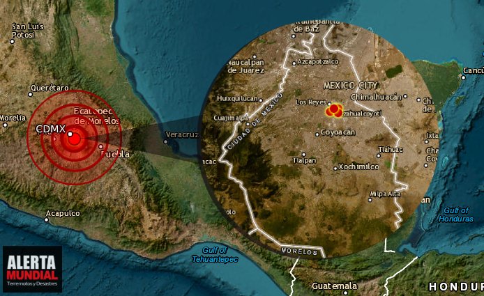
Strange earthquakes in Mexico City (CDMX) commonly occur in the area of the Popocatepetl volcano, on the coasts of Guerrero, Michoacan, Oaxaca and Chiapas...Rarely in the center of the republic.

Four earthquakes in a row are registered in the CDMX in a matter of minutes...

Earthquakes detected in the CDMX, Mexico, this Tuesday, February 21, 2023, reports the National Seismological (CSN).

Today Tuesday afternoon four consecutive earthquakes were registered with epicenter in the area of Iztacalco, Mexico City; no material damages were reported.

The quakes had a magnitude of 2.1, 1.9, 1.2 and 1.9 and were registered at 16:44, 16:48, 16:52 and 16:58 with epicenter in Iztacalco, Mexico City, said the National Seismological (CSN).

This afternoon, the SSN reports three earthquakes to the east of CDMX with epicenter south of Palacio de los Deportes. Perceived in neighborhoods near the epicenter.

1. M1.9 - 16:48 h.
2. M1.2 - 16:52 h.
3. M1.9 - 16:58 h.

At 18:21 h a fourth earthquake was reported.

SSN has registered 261 earthquakes with epicenter in CDMX from January 01, 1990 to date. Mexico City is located on what used to be Lake Texcoco. Iztacalco is number 8 on the following map showing where CDMX and the former Texcoco Lake are located. At number 6 was the ancient Tenochtitlan.

D_XfYLtXUAQoiMn.jpg
 
WORLDWIDE EARTHQUAKE REPORT FEBRUARY 22/2023

Major magnitude 6.8 earthquake - Tajikistan-Xinjiang Border Region on Thursday, February 23, 2023 at 00:37
M 6.8 - 67 km W of Murghob, Tajikistan
2023-02-23 00:37:40 (UTC)
38.073°N 73.208°E. 20.5 km depth
Estimated energy release: 14. 9 atomic bombs
USGS earthquake alert

Data for the same earthquake reported by different agencies

Mag.DepthLocationSource
6.821 kmTajikistan-Xinjiang Border RegionUSGS
6.710 km67 Km W of Murghob, TajikistanGFZ


● M 5.6 - Kepulauan Babar, Indonesia
2023-02-22 09:34:04 (UTC)
7.061°S 129.457°E. 124.8 km depth
USGS earthquake alert

● M 5.0 - 112 km E of Gerāsh, Iran
2023-02-22 01:11:07 (UTC)
27.769°N 55.272°E. 10.0 km depth
USGS earthquake alert

● Summary

Seismic activity level has been at moderate levels in the last 24 hours. This is the last chart posted by Volcanodiscovery at 01:00 UTC on February 23 Global seismic activity chart
~1 quake above magnitude 6
~2 quakes between magnitude 5 and 6
~41 quakes between magnitude 4 and 5
~143 quakes between magnitude 3 and 4
~412 quakes between magnitude 2 and 3
~668 quakes below magnitude 2 that people normally don't feel.
~1267 earthquakes in the past 24h (1373 earthquakes in the 24 hours prior to this report) Estimated combined seismic energy release: 294 gigawatt hours, equivalent to 2.5 x 10⁵ tons of TNT or 15.8 atomic bomb
Volcanodiscovery earthquake report 24h
 
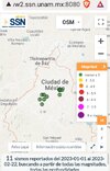
Four earthquakes in a row are registered in the CDMX in a matter of minutes...

1. M1.9 - 16:48 h.
2. M1.2 - 16:52 h.
3. M1.9 - 16:58 h.

At 18:21 h a fourth earthquake was reported..
Fifth

SEISM
Magnitude 1.5
Loc. 2 km SOUTHWEST of IZTACALCO, CDMX
22/02/23 20:34:53
Lat 19.38 Lon -99.11
Pf 2 km

This year there had been several with epicenter in Mexico City, small ones below 3 magnitude.
 

Attachments

  • Screenshot_20230222_221423.jpg
    Screenshot_20230222_221423.jpg
    221.6 KB · Views: 0
M 6.8 - 67 km W of Murghob, Tajikistan
2023-02-23 00:37:40 (UTC)
38.073°N 73.208°E. 20.5 km depth
Estimated energy release: 14. 9 atomic bombs
USGS earthquake alert

Aftershocks greater than magnitude 4.0 in Tajikistan so far

● M 5.0 - 86 km W of Murghob, Tajikistan
2023-02-23 00:55:14 (UTC)
38.147°N 72.982°E. 10.0 km depth
USGS earthquake alert

● M 4.6 - 103 km W of Murghob, Tajikistan
2023-02-23 01:06:05 (UTC)
38.180°N 72.783°E. 10.0 km depth
USGS earthquake alert

● M 4.9 - 60 km W of Murghob, Tajikistan
2023-02-23 01:35:57 (UTC)
38.182°N 73.279°E. 10.0 km depth
USGS earthquake alert

● M 4.8 - 64 km W of Murghob, Tajikistan
2023-02-23 02:07:46 (UTC)
38.182°N 73.235°E. 10.0 km depth
USGS earthquake alert

● M 4.7 - 77 km WNW of Murghob, Tajikistan
2023-02-23 02:18:00 (UTC)
38.336°N 73.107°E. 10.0 km depth
USGS earthquake alert

6.8 earthquake shakes lightly populated part of Tajikistan​


A 6.8 magnitude earthquake shook a lightly populated, remote part of Tajikistan early Thursday near China’s far western Xinjiang region.

It was 67 kilometers (41 miles) west of Murghob, Tajikistan, and 20 kilometers (12 miles) below ground, according to the U.S. Geological Survey.

Mughrob is the district capital with a population of a few thousand people high in the Pamir Mountains.

The quake was strongly felt across the border in some areas of Kashgar prefecture and Kizilsu Kyrgyz autonomous prefecture in Xinjiang, but no casualties or damage has been reported so far, state media CCTV said, citing local information officers.

China Earthquake Networks Center said the quake was 7.2 magnitude and 10 kilometers (6 miles) deep. Measurements by different agencies often differ.

 
Seismic activity in South America

M 5.5 - 151 km WSW of San Antonio, Chile
2023-02-23 10:23:38 (UTC)
33.924°S 73.200°W. 26.8 km depth
USGS earthquake alert
Strong mag. 5.5 earthquake - South Pacific Ocean, 176 km southwest of Valparaiso, Region de Valparaiso, Chile, on Thursday, Feb 23, 2023 at 5:23 am The quake occurred 152 km (94 mi) WSW of San Antonio (pop: 85,700) at a shallow depth of 27 km

M 5.3 - 61 km WNW of San Antonio de los Cobres, Argentina
2023-02-23 13:01:20 (UTC)
24.047°S 66.898°W. 214.0 km depth
USGS earthquake alert
Moderate mag. 5.3 earthquake - 163 km west of Jujuy, Departamento de Doctor Manuel Belgrano, Jujuy, Argentina, on Thursday, Feb 23, 2023 at 10:01 am local time at a considerable depth of 214 lm
 
WORLDWIDE EARTHQUAKE REPORT FEBRUARY 23/2023

There is no doubt that the earthquake in Turkey moved something globally. These are the records from January 30 to February 05.

January 30
~767 earthquakes in the past 24h
January 31
~810 earthquakes in the past 24h
February 01
~835 earthquakes in the past 24h
February 02
~845 earthquakes in the past 24h
February 03
~824 earthquakes in the past 24h
February 04
~704 earthquakes in the past 24h
February 05
~643 earthquakes in the past 24h

Since the earthquake occurred in Turkey, the daily record exceeds 1000 earthquakes. In the past 24 hours alone, 1234 earthquakes occurred around the world. It is also worth noting the prevalence of minor earthquakes below magnitude 2. The Earth is shivering

(Joe) In the last session, they said that soon things will become very chaotic and strange and that it would give many people chills. Was this situation that we're in now what they were talking about?

A: Partly. There are chills of different kinds.

The third M5.0 earthquake occurred in the Pacific Ocean.

● M 5.0 - central East Pacific Rise
2023-02-23 17:21:55 (UTC)
6.082°S 106.448°W. 10.0 km depth
USGS earthquake alert
chrome_screenshot_1677201215436.png
M 4.5 - northern East Pacific Rise
2023-02-23 08:27:11 (UTC)
14.987°N 104.502°W. 16.7 km depth
USGS earthquake alert

After the M6.3 earthquake in Indonesia this morning, only earthquakes of magnitude 3+ and 4+ have occurred.

● Earthquake Forecast: updated 23 February 2023, 14:00 UTC Some seismic increase may occur around 25-26 February, but probably not much. The first week of March will be critical. SSGEOS

MAGNITUDE PROBABILITY

updated 23 February 2023, 14:00 UTC
M 6.0-6.4M 6.5-6.9M 7.0-8.4M 8.5+
50%40%40%30%

● Summary

Seismic activity level has been at moderate levels in the last 24 hours. This is the last chart posted by Volcanodiscovery at 01:00 UTC on February 24 Global seismic activity chart
~1 quake above magnitude 6
~3 quakes between magnitude 5 and 6
~45 quakes between magnitude 4 and 5
~124 quakes between magnitude 3 and 4
~419 quakes between magnitude 2 and 3
~651 quakes below magnitude 2 that people normally don't feel.
~1243 earthquakes in the past 24h (1267 earthquakes in the 24 hours prior to this report) Estimated combined seismic energy release: 294 gigawatt hours, equivalent to 2.5 x 10⁵ tons of TNT or 15.8 atomic bomb
Volcanodiscovery earthquake report 24h
 
WORLDWIDE EARTHQUAKE REPORT FEBRUARY 24/2023

●M 5.0 - 152 km SE of San Jose Village, Northern Mariana Islands
2023-02-24 15:24:47 (UTC)
14.071°N 146.696°E. 10.0 km depth
USGS earthquake alert

Turkey has recorded light to moderate seismic activity. According to USGS the earthquake northwest of Sincik was recorded at a depth of 0.0 km. This is only possible when it is not possible to determine the depth, by mistake or by an explosion...a big explosion (More or less 30 tons of TNT)


●M 4.5 - Central Turkey
2023-02-24 14:02:01 (UTC)
37.969°N 33.988°E. 18.5 km depth
USGS earthquake alert

●M 4.5 - 7 km NE of Sincik, Turkey
2023-02-24 20:25:28 (UTC)
38.083°N 38.669°E. 0.0 km depth
USGS earthquake alert

●M 4.2 - eastern Turkey
2023-02-25 00:28:10 (UTC)
38.995°N 41.099°E. 10.0 km depth
USGS earthquake alert

●M 4.2 - 9 km WNW of Uzunbağ, Turkey
2023-02-25 01:12:20 (UTC)
36.163°N 35.934°E. 10.0 km depth
USGS earthquake alert

What does it mean that the earthquake occurred at a depth of 0 km? How can an earthquake have a negative depth; that would mean it’s in the air. What is the geoid, and what does it have to do with earthquake depth?​


An earthquake cannot physically occur at a depth of 0 km or -1km (above the surface of the earth). In order for an earthquake to occur, two blocks of crust must slip past one another, and it is impossible for this to happen at or above the surface of the earth. So why do we report that the earthquake occurred at a depth of 0 km or event as a negative depth sometimes?
First of all, the depth of an earthquake is usually the most difficult part of its location to nail down with great accuracy. Since most earthquakes are deep within the crust, an error of +/- 1 or 2 km is irrelevant; in other words, it is a small error when the depth is something like 13 km. If the earthquake depth is relatively shallow, however, it becomes more of an issue. A negative depth can sometimes be an artifact of the poor resolution for a shallow event.
For quarry blasts that are recorded by the seismic network, the depth is fixed at 0 km since we can never determine a precise depth for these, but we know they are very close to the surface.

● Summary

Seismic activity level has been at low levels in the last 24 hours. This is the last chart posted by Volcanodiscovery at 02:00 UTC on February 25 Global seismic activity chart
~1 quake above magnitude 5
~33 quakes between magnitude 4 and 5
~138 quakes between magnitude 3 and 4
~399 quakes between magnitude 2 and 3
~630 quakes below magnitude 2 that people normally don't feel.
~1201 earthquakes in the past 24h (1243 earthquakes in the 24 hours prior to this report) Estimated combined seismic energy release: 294 gigawatt hours, equivalent to 2.5 x 10⁵ tons of TNT or 15.8 atomic bomb
Volcanodiscovery earthquake report 24h
 
Strong earthquake in Japan

M 6.0 - 61 km ESE of Kushiro, Japan
2023-02-25 13:27:42 (UTC)
42.780°N 145.074°E. 50.2 km depth
USGS earthquake alert

A shallow magnitude 6.0 earthquake was reported late at night 61 km (38 mi) ESE of Kushiro (pop: 183,600) Kushiro Shi, Hokkaido, Japan. According to the United States Geological Survey, the quake hit on Saturday, February 25th, 2023, at 11:27 pm local time at a moderately shallow depth of 50 km.

Data for the same earthquake reported by different agencies
Mag.DepthLocationSource
6.050 kmHokkaido, Japan RegionUSGS
6.568 kmJapan: OFF NEMURO PENINSULANIED
6.050 kmHokkaido, Japan RegionRaspberry
Shake
5.910 kmJapan: Near SapporoRENASS
6.120 kmJapan [Sea]INGV
6.156 kmHokkaido, Japan RegionGFZ
6.142 kmHokkaido, Japan RegionGeoAu
6.110 kmHokkaido, Japan RegionIRIS
6.060 kmJapan: 日本北海道附近海域CEIC
6.150 kmHOKKAIDO, JAPAN REGIONEMSC
Volcanodiscovery
 
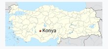
I think this sinkhole at Konya, Turkey; may be related to this earthquake.


#Watch - a hole,# Show it _ bit _ the _ people, # and confused _ the _ scholars!! ️

A deep hole with a diameter of 37 meters and a depth of 12 meters suddenly appeared in the Turkish state of Konya
The newly appeared crater after the earthquake

M 5.3 - central Turkey
Time 2023-02-25 04:27:12 (UTC-06:00)
Location 37.996°N 34.019°E
Depth 17.0 km
 

Attachments

  • Screenshot_20230225_123922.jpg
    Screenshot_20230225_123922.jpg
    66.3 KB · Views: 1
Strong earthquake in Papua New Guinea

M 6.2 - 29 km ENE of Kandrian, Papua New Guinea
2023-02-25 21:24:48 (UTC)
6.111°S 149.793°E. 38.2 km depth
59 km (36 mi) SE of Kandrian (pop: 1,010)
USGS earthquake alert

Data for the same earthquake reported by different agencies

Mag.DepthLocationSource
6.565 kmNew Britain Region, Papua New GuineaUSGS
5.910 kmNew Britain Region, Papua New GuineaGFZ
5.610 kmPapua New Guinea: Near Port MoresbyRENASS
6.565 kmPapua New Guinea: New Britain Region, P.N.G.Raspberry
Shake
 
WORLDWIDE EARTHQUAKE REPORT FEBRUARY 25/2023

●M 5.2 - 19 km ENE of Emirgazi, Turkey
2023-02-25 10:27:12 (UTC)
37.994°N 34.022°E. 16.5 km depth
USGS earthquake alert

●M 5.1 - 133 km NW of Ishikawa, Japan
2023-02-25 22:45:44 (UTC)
27.165°N 126.767°E. 10.0 km depth
USGS earthquake alert

●M 5.1 - South Pacific Ocean, Fiji,
2023-02-25 10:25:44 (UTC)
23.51874°S 179.33847°W 612.5 km depth
GEONET

●M 5.1 - southern Mid-Atlantic Ridge
2023-02-25 05:00:01 (UTC)
47.267°S 13.342°W. 10.0 km depth
USGS earthquake alert

●M 5.0 - 145 km S of Vilyuchinsk, Russia
2023-02-25 06:25:22 (UTC)
51.626°N 158.622°E. 70.1 km depth
USGS earthquake alert

● Three earthquakes were recorded in the Michoacan Gap

M 4.7 - off the coast of Michoacan, Mexico
2023-02-25 06:51:37 (UTC)
15.359°N 104.627°W. 10.0 km depth
USGS earthquake alert

M 4.4 - off the coast of Michoacan, Mexico
2023-02-25 06:56:52 (UTC)
15.194°N 104.209°W. 10.0 km depth
USGS earthquake alert

M 4.3 - off the coast of Michoacan, Mexico
2023-02-25 07:28:08 (UTC)
15.167°N 104.443°W. 10.0 km depth
USGS earthquake alert

The Michoacan Gap is a seismic gap located in the Mexican Pacific Ocean, off the coast of the states of Michoacan and Guerrero, with an extension in the order of 200 km, from Petatlan, Guerrero to Maruata, Michoacan. Like the Guerrero rift, it is located within the subduction zone between the Cocos Plate and the North American plate, where the former is introduced below the latter. The 1985 Mexico earthquake, which left numerous victims and damage in Mexico City, took place in this region. Wikipedia
chrome_screenshot_1677378157394.png

● Atmospheric fluctuations 25 February 2023.Potential for increased seismic activity in or near the purple bands.

● Summary

Seismic activity level has been at moderate levels in the last 24 hours. This is the last chart posted by Volcanodiscovery at 01:00 UTC on February 65 Global seismic activity chart
~2 quakes above magnitude 6
~5 quakes between magnitude 5 and 6
~43 quakes between magnitude 4 and 5
~111 quakes between magnitude 3 and 4
~378 quakes between magnitude 2 and 3
~550 quakes below magnitude 2 that people normally don't feel.
~1089 earthquakes in the past 24h (1201 earthquakes in the 24 hours prior to this report) Estimated combined seismic energy release: 52137 tons of TNT or 3.3 atomic bombs.
Volcanodiscovery earthquake report 24h
 
This week saw 6 M6 earthquakes, all M6.1 and in New Zealand, Indonesia and the Philippines.
In the usual area, there were 3 out of 111 earthquakes worldwide equal to or greater than 4.5 and 1552 out of 1893 quakes of all sizes.
Percentage: 82.0%
Last week saw 5 M6 earthquakes with the highest being a M6.8 in Tajikistan.
In the usual area, there were 6 out of 109 earthquakes worldwide equal to or greater than 4.5 and 1618 out of 1851 quakes of all sizes.
Percentage: 87.4%
Earthquakes 7 days to February 26th 2023.gif
 
WORLDWIDE EARTHQUAKE REPORT FEBRUARY 26/2023

The Kermadec Islands in New Zealand were shaken by three almost consecutive earthquakes. The first quake had a magnitude of 4.6, a second quake 24 minutes later was reported by GEONET with a magnitude 5.0 and later updated by USGS to magnitude 4.9. Finally, the third earthquake recorded a magnitude 5.0.

~M 4.6 - Kermadec Islands, New Zealand
2023-02-26 11:13:16 (UTC)
30.248°S 177.694°W. 26.5 km depth

~M 4.9 - Kermadec Islands, New Zealand
2023-02-26 11:37:41 (UTC)
30.215°S 177.561°W. 26.2 km depth

~M 5.0 - Kermadec Islands, New Zealand
2023-02-26 11:48:16 (UTC)
30.279°S 177.525°W. 22.5 km depth
USGS earthquake alert

● M 5.1 - 118 km NNW of Naisano Dua, Indonesia
2023-02-26 16:41:15 (UTC)
8.610°S 123.349°E. 189.5 km depth
USGS earthquake alert

● M 5.0 - 120 km WSW of Adak, Alaska
2023-02-26 13:53:18 (UTC)
51.609°N 178.330°W. 45.2 km depth
USGS earthquake alert

● M 5.0 - 77 km NNW of Aksu, China
2023-02-26 23:58:05 (UTC)
41.805°N 79.868°E. 10.0 km depth
USGS earthquake alert

● Three earthquakes were recorded in the Michoacan Gap
Fourth earthquake recorded in the Michoacan Gap, Mexico

~ M 4.4 - off the coast of Michoacan, Mexico
2023-02-26 16:30:03 (UTC)
15.132°N 104.435°W. 15.8 km depth
USGS earthquake alert

● Subduction zones that have remained quiet in recent years.
Most of the world’s earthquakes, tsunamis, landslides, and volcanic eruptions are caused by the continuous motions of the many tectonic plates that make up the Earth’s outer shell. The most powerful of these natural hazards occur in subduction zones, where two plates collide and one is thrust beneath another. USGS

● Summary

Seismic activity level has been at moderate levels in the last 24 hours. This is the last chart posted by Volcanodiscovery at 00:00 UTC on February 27 Global seismic activity chart
~5 quakes above magnitude 5
~33 quakes between magnitude 4 and 5
~98 quakes between magnitude 3 and 4
~361 quakes between magnitude 2 and 3
~578 quakes below magnitude 2 that people normally don't feel.
~1075 earthquakes in the past 24h (1089 earthquakes in the 24 hours prior to this report) Estimated combined seismic energy release: 6536 tons of TNT or 0.4 atomic bombs.
Volcanodiscovery earthquake report 24h
 

Trending content

Back
Top Bottom