Earthquakes around the world

Last week saw 1 M7.6 earthquake in Tonga and no M6 earthquakes.
In the usual area, there were 9 out of 93 earthquakes worldwide equal to or greater than 4.5 and 1860 out of 2296 quakes of all sizes.
Percentage: 81.0%
Last week saw 2 M7, both in the Loyalty Islands region (M7.7 and M7.7) and 2 M6, being a M6.5 also in the Loyalty Islands region & a M6.4 in Guatamala.
In the usual area, there were 3 out of 143 earthquakes worldwide equal to or greater than 4.5 and 1629 out of 2113 quakes of all sizes.
Percentage: 77.1%
Earthquakes 7 days to May 21st 2023.gif
 

Strong mag. 6.1 earthquake - 188 km southeast of Honiara, Solomon Islands

Date & timeMay 21, 2023 15:45:13 UTC - 49 minutes ago
Local time at epicenterMonday, May 22, 2023 at 2:45 am (GMT +11)
StatusConfirmed
Magnitude6.1
Depth77.8 km
Epicenter latitude / longitude10.2728°S / 161.4442°E
SB.png
(Solomon Islands)
Antipode10.273°N / 18.556°W
Shaking intensityStrong shaking
Felt3 reports
Primary data sourceUSGS (United States Geological Survey)
Nearest volcanoGallego (214 km / 133 mi)
 
WORLDWIDE EARTHQUAKE REPORT MAY 21_2023

M 6.8 - Prince Edward Islands region
2023-05-21 14:56:45 (UTC)
43.436°S 39.368°E. 10.0 km depth
USGS earthquake alert
Aftershock

● M 5.1 - Prince Edward Islands region
2023-05-21 17:23:20 (UTC)
43.863°S 39.479°E. 10.0 km depth
USGS earthquake alert

According to Volcanodiscovery data, this M6.8 has been the strongest earthquake in the region in the last 100 years

On december 18, 2021 ocurred a very strong magnitude 6.0 earthquake.

The energy from the M7+ earthquakes in the South Pacific Ocean is migrating westward and is expected to impact eastward, mainly Chile, although Central America and Mexico are not ruled out. California has already been shaken by an M5.5 earthquake and is expected to stop there or continue on its way to Alaska. Japan has already recorded a M5.5 earthquake, M5.8 in Tonga, M5.3 in Papua New Guinea and M5.4 west of Macquarie Island.

chrome_screenshot_1684689571847.png

● M 5.8 - 109 km SE of Neiafu, Tonga
2023-05-21 05:23:11 (UTC)
19.413°S 173.327°W. 10.0 km depth
USGS earthquake alert

● M 5.2 - 106 km SE of Neiafu, Tonga
2023-05-21 11:26:03 (UTC)
19.400°S 173.351°W. 10.0 km depth
USGS earthquake alert

● M 5.5 - 129 km WSW of Kurio, Japan
2023-05-21 22:20:05 (UTC)
29.831°N 129.183°E. 189.4 km depth
USGS earthquake alert

● M 5.4 - west of Macquarie Island
2023-05-21 21:11:41 (UTC)
52.201°S 139.690°E. 10.0 km depth
USGS earthquake alert
chrome_screenshot_1684715586147.png

● M 5.3 - eastern New Guinea region, Papua New Guinea
2023-05-21 18:53:18 (UTC)
6.051°S 147.586°E. 62.6 km depth
USGS earthquake alert

● Summary

Seismic activity level has been at high levels in the last 24 hours. This is the last chart posted by Volcanodiscovery at 23:00 UTC on May 21 Global seismic activity chart
  • 2 quakes above magnitude 6
  • 7 quakes between magnitude 5 and 6
  • 47 quakes between magnitude 4 and 5
  • 107 quakes between magnitude 3 and 4
  • 276 quakes between magnitude 2 and 3
  • 557 quakes below magnitude 2 that people normally don't feel.
~996 earthquakes in the past 24h (794 earthquakes in the 24 hours prior to this report) Estimated combined seismic energy release: 328 gigawatt hours, equivalent to 2.8 x 10⁵ tons of TNT or 17.6 atomic bombs
Volcanodiscovery earthquake report 24h
 
WORLDWIDE EARTHQUAKE REPORT MAY 22_2023

New aftershocks in the Loyalty Islands region

●M 5.5 - southeast of the Loyalty Islands
2023-05-22 06:52:47 (UTC)
23.749°S 171.676°E. 30.5 km depth
USGS earthquake alert

●M 5.0 - southeast of the Loyalty Islands
2023-05-22 21:45:56 (UTC)
22.884°S 170.432°E. 10.0 km depth
USGS earthquake alert

● M 5.1 - 236 km ESE of Tadine, New Caledonia
2023-05-22 22:54:13 (UTC)
22.644°S 169.851°E. 10.0 km depth
USGS earthquake alert
chrome_screenshot_1684799406415.png

●M 5.3 - 150 km ENE of Gizo, Solomon Islands
2023-05-22 13:36:13 (UTC)
7.667°S 158.135°E. 10.0 km depth
USGS earthquake alert

●M 5.2 - Banda Sea
2023-05-22 04:45:20 (UTC)
6.622°S 129.281°E. 10.0 km depth
USGS earthquake alert

●M 5.1 - near the south coast of Honshu, Japan
2023-05-22 07:42:40 (UTC)
34.433°N 139.305°E. 10.0 km depth
USGS earthquake alert

●M 5.1 - 33 km NE of Hihifo, Tonga
2023-05-22 13:30:38 (UTC)
15.738°S 173.575°W. 39.0 km depth
USGS earthquake alert

●M 5.0 - 78 km NNE of Sarupathar, India
2023-05-22 02:45:36 (UTC)
26.900°N 96.983°E. 10.0 km depth
USGS earthquake alert

●M 4.5 - 49 km E of Hashtrūd, Iran
2023-05-22 17:36:59 (UTC)
37.491°N 47.611°E. 10.0 km depth
USGS earthquake alert

●M 4.2 - 6 km S of Fântânele, Romania
2023-05-22 17:46:42 (UTC)
46.070°N 21.398°E. 11.3 km depth
USGS earthquake alert


● Summary

Seismic activity level has been at moderate levels in the last 24 hours. This is the last chart posted by Volcanodiscovery at 23:00 UTC on May 22 Global seismic activity chart
  • 8 quakes above magnitude 5
  • 35 quakes between magnitude 4 and 5
  • 118 quakes between magnitude 3 and 4
  • 303 quakes between magnitude 2 and 3
  • 542 quakes below magnitude 2 that people normally don't feel.
~1006 earthquakes in the past 24h (996 earthquakes in the 24 hours prior to this report) Estimated combined seismic energy release: 10877 tons of TNT or 0.7 atomic bombs.
Volcanodiscovery earthquake report 24h
 

Generation of equatorial plasma bubble after the 2022 Tonga volcanic eruption​


Abstract.
Equatorial plasma bubbles are a phenomenon of plasma density depletion with small-scale density irregularities, normally observed in the equatorial ionosphere. This phenomenon, which impacts satellite-based communications, was observed in the Asia-Pacific region after the largest-on-record January 15, 2022 eruption of the Tonga volcano. We used satellite and ground-based ionospheric observations to demonstrate that an air pressure wave triggered by the Tonga volcanic eruption could cause the emergence of an equatorial plasma bubble. The most prominent observation result shows a sudden increase of electron density and height of the ionosphere several ten minutes to hours before the initial arrival of the air pressure wave in the lower atmosphere. The propagation speed of ionospheric electron density variations was ~ 480–540 m/s, whose speed was higher than that of a Lamb wave (~315 m/s) in the troposphere. The electron density variations started larger in the Northern Hemisphere than in the Southern Hemisphere. The fast response of the ionosphere could be caused by an instantaneous transmission of the electric field to the magnetic conjugate ionosphere along the magnetic field lines. After the ionospheric perturbations, electron density depletion appeared in the equatorial and low-latitude ionosphere and extended at least up to ±25° in geomagnetic latitude.


Kilauea Earthquakes, Lava Tubes, Solar Project, Kona Parking (May 22, 2023)


Ahyi Seamount Activity. West Coast Earthquake update. Monday night 5/22/2023
May 23, 2023, TheEarthMaster


M 6.1 - 288 km E of Vao, New Caledonia
 
WORLDWIDE EARTHQUAKE REPORT MAY 23_2023

Seismic activity continues in the Loyalty Islands region. Three strong earthquakes shook the island, two M5+ and one M6.1.

M 6.1 - 288 km E of Vao, New Caledonia
2023-05-23 06:41:58 (UTC)
● M 5.0 - southeast of the Loyalty Islands
2023-05-23 06:22:14 (UTC)
23.2515°S 170.6168°E. 32.8 km depth

● M 5.0 - southeast of the Loyalty Islands
2023-05-23 09:26:43 (UTC)
22.857°S 170.839°E. 42.9 km depth
USGS earthquake alert

M 5.1 - 207 km NW of Tobelo, Indonesia
2023-05-23 15:04:55 (UTC)
3.114°N 126.752°E. 45.9 km depth
USGS earthquake alert

M 5.0 - New Ireland region, Papua New Guinea
2023-05-23 13:00:37 (UTC)
3.835°S 151.551°E. 10.0 km depth
USGS earthquake alert

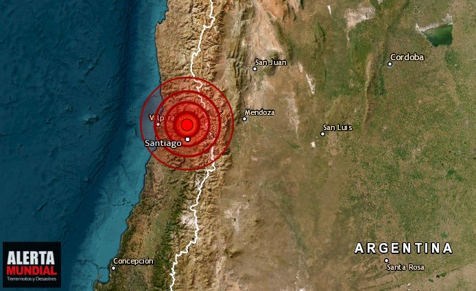
Seismic activity continues at moderate levels in Chile. The highest magnitude earthquake has been 4.5. The energy of the earthquakes on Loyalty Island has not exploded in South America and Central America.

● M 4.5 - 56 km W of Talcahuano, Chile
2023-05-23 22:57:32 (UTC)
36.799°S 73.741°W. 17.2 km depth
USGS earthquake alert

Concern about the accumulation of seismic energy in northern Chile.

The article was published in the journal "Geophysical Research Letters" and provides information on seismic conditions in Chile. According to Chilean researchers, a significant accumulation of seismic energy has been detected in the Antofagasta region in the north of the country, which has experienced several moderate-intensity telluric movements in recent months.

The study, based on a coupling model of the Chilean subduction, uses advanced mathematical and computational tools to analyze the deformation and rotation of the South American continental plate. The researchers involved in this study are Francisco Ortega Culaciati and Vicente Yáñez Cuadra, from the Department of Geophysics (DGF) of the University of Chile.

One of the highlights of this study is a new method developed to estimate the degree of coupling or seismic potential along the interface of the Nazca and South American tectonic plates between Antofagasta and La Serena. Calculating the coupling between tectonic plates is a complex challenge, since it is performed from measurements of movements at the Earth's surface, even though the events occur at a depth of several kilometers.

The analysis includes considerations on the effects of previous seismic movements, as well as tectonic and geological processes, such as the coupling between tectonic plates, the rotation and translation of tectonic microplates, deformations in the Earth's mantle and even the uplift of the Andes Mountains.

The first conclusions of the study indicate a high accumulation of seismic energy in the area closest to the tectonic plate contact off the coast of Antofagasta, where an earthquake of magnitude 8.0 occurred in 1995. Two other areas with a high degree of coupling between tectonic plates were also identified, located in the areas of Taltal and Copiapó, and Vallenar and La Serena.

Francisco Ortega warned that the so-called "Atacama seismic lagoon" has been affected by earthquakes in the past, such as those that occurred in 1819 and 1922, separated by almost 100 years. Although it is not possible to predict when the next major earthquake will occur in the area, it is reasonable to expect that the energy accumulated since 1922 will be released sometime in the future.

It is important to remember that in 1960, the city of Valdivia, in the Los Rios region, experienced the strongest earthquake recorded in modern times, with a magnitude of 9.5 on the Richter scale.

● Summary

Seismic activity level has been at moderate levels in the last 24 hours. This is the last chart posted by Volcanodiscovery at 23:00 UTC on May 23 Global seismic activity chart
  • 1 quake above magnitude 6
  • 4 quakes between magnitude 5 and 6
  • 44 quakes between magnitude 4 and 5
  • 90 quakes between magnitude 3 and 4
  • 232 quakes between magnitude 2 and 3
  • 557 quakes below magnitude 2 that people normally don't feel.
~928 earthquakes in the past 24h (1006 earthquakes in the 24 hours prior to this report) Estimated combined seismic energy release: 28052 tons of TNT or 1.8 atomic bombs
Volcanodiscovery earthquake report 24h
 
WORLDWIDE EARTHQUAKE REPORT MAY 24_2023

The seismic energy from the Loyalty Islands M7.7 earthquake and M7.6 earthquake in Tonga is moving as expected and the latest major earthquake shook the Banda sea in Indonesia.
M 6.2 - Banda Sea
2023-05-24 15:49:34 (UTC)
According to Ka-tet's forecast for the next 7-10 days is likely:

● Indonesia at worst case M6+.
chrome_screenshot_1684689571847.png
Atmospheric fluctuations were detected five days ago
M4+ earthquakes have been recorded in China, Nepal, Japan and Iran so far, but we have not seen a larger magnitude response in the Americas. SSGEOS mentions the following
Powerful atmospheric fluctuations (detected 3 days ago) indicate the possibility of a M 7-8 #earthquake in the Atlantic, South/Central America or the Caribbean.
20230524_150501.jpg

The last highest magnitude earthquake in the Americas occurred in Guatemala with a M6.4 and was an intraplate earthquake.
M 6.4 - 2 km SE of Canillá, Guatemala

chrome_screenshot_1684964218975.png
Guatemala thus becomes a fulcrum point and an equal response is expected on both sides of the epicenter. In 2017 there was also a 6.8 earthquake in Guatemala that was intraplate and two months later a magnitude 7.1 quake shook the state of Morelos in Mexico and was catastrophic for Mexico City.

Ka-tet mentions that it is very possible an intraplate earthquake with origin in the region of Puebla and Morelos in the coming days Ka-tet estimates a M5+ earthquake and in the worst case M6+

The greatest concentration of energy is in Central America and the Caribbean and to a lesser extent in Ecuador and Peru. But so far there is no compensation in Chile, so it is estimated an earthquake M6+ and in the worst case M7+ in the coming days.

M 5.5 - Pacific-Antarctic Ridge
2023-05-24 10:33:19 (UTC)
56.870°S 140.846°W. 10.0 km depth
USGS earthquake alert

M 5.2 - 40 km SSW of Maitum, Philippines
2023-05-24 00:44:06 (UTC)
5.693°N 124.379°E. 10.0 km depth
USGS earthquake alert

M 5.0 - 101 km ESE of Kokopo, Papua New Guinea
2023-05-24 13:15:06 (UTC)
4.664°S 153.124°E. 56.6 km depth
USGS earthquake alert

M 5.0 - southeast of the Loyalty Islands
2023-05-24 22:23:22 (UTC)
23.360°S 171.073°E. 10.0 km depth
USGS earthquake alert

M 4.6 - 72 km WNW of Candelaria, Argentina
2023-05-24 15:17:48 (UTC)
31.857°S 66.556°W. 132.0 km depth
USGS earthquake alert

M 4.6 - 178 km WSW of Lebu, Chile
2023-05-24 18:28:55 (UTC)
38.375°S 75.442°W. 18.0 km depth
USGS earthquake alert

● Summary

Seismic activity level has been at moderate levels in the last 24 hours. This is the last chart posted by Volcanodiscovery at 23:00 UTC on May 24 Global seismic activity chart
  • 1 quake above magnitude 6
  • 5 quakes between magnitude 5 and 6
  • 37 quakes between magnitude 4 and 5
  • 103 quakes between magnitude 3 and 4
  • 257 quakes between magnitude 2 and 3
  • 541 quakes below magnitude 2 that people normally don't feel.
~944 earthquakes in the past 24h (928 earthquakes in the 24 hours prior to this report) Estimated combined seismic energy release: 37664 tons of TNT or 2.4 atomic bombs.
Volcanodiscovery earthquake report 24h
 

Attachments

  • chrome_screenshot_1684964218975.png
    chrome_screenshot_1684964218975.png
    1.7 MB · Views: 1
Seismic response arrived in Panama, as expected in Central America.

According to Ka-tet's forecast for the next 7-10 days is likely:

● Southern Mexico (Guerrero and Chiapas), and Central America (towards the Gulf of Panama) M6+ in the worst case M7+

M 6.6 - Panama-Colombia border region
2023-05-25 03:05:33 (UTC)
8.889°N 77.123°W
10.0 km depth
USGS earthquake alert

Data for the same earthquake reported by different agencies​

Mag.DepthLocationSource
6.610 kmPanama-Colombia Border RegionUSGS
6.510 kmPanama-Colombia Border RegionGFZ
6.710 kmColombia: 96 Km Al Norte De Ustupo, PanamáINETER
6.610 kmColombia: Near CartagenaRENASS
6.610 kmPanama-Colombia Border RegionRaspberry
Shake
6.68.6 kmColombia [Sea]INGV
6.610 kmPanama-Colombia Border RegionIRIS
6.310 kmPanama-Colombia Border RegionGeoAu
6.640 kmPANAMA-COLOMBIA BORDER REGIONEMSC
 
Back
Top Bottom