Earthquakes around the world

Very strong mag. 6.6 Earthquake - 52 km northeast of Bislig City, Province of Surigao del Sur, Caraga, Philippines

Date & timeDec 3, 2023 10:35:57 UTC - 2 hours 47 minutes ago
Local time at epicenterSunday, Dec 3, 2023 06:35 pm (GMT +8)
StatusConfirmed
Magnitude6.6
Depth56.2 km
Epicenter latitude / longitude8.4498°N / 126.7204°E
ph.png
Philippines
Antipode8.4498°S / 53.28°W
Shaking intensityModerate shaking
Felt56 reports
Primary data sourceUSGS (United States Geological Survey)
Nearest volcanoLeonard Range (140 km / 87 mi)
 
It is a shame that SSGEOS no longer publishes its planetary and lunar geometry analysis
I checked their site today, there's this:

A convergence of critical planetary geometry can result in major seismic activity in the first week of December, potentially reaching mid 7 magnitude or larger.


CaptureEQ.PNG

Even without any detailed explanations, we can see that last week was very "busy" regarding planetary geometry, lot of events around 28/30 november.
 
Last week saw 3 M6 earthquakes with the highest being a M6.9 in the Mariana Islands.
In the usual area, there were 2 out of 108 earthquakes equal to or greater than 4.5 and 1259 out of 1740 quakes of all sizes.
Percentage: 72.4%
Last week saw 1 M7 (M7.6 in the Philippines) and 7 M6, with the highest of those being a M6.9 also in the Philippines)
In the usual area, there were 7 out of 224 earthquakes equal to or greater than 4.5 and 1417 out of 1888 quakes of all sizes.
Percentage: 75.1%
Earthquakes 7 days to Dec 3rd 2023.gif
 
WORLDWIDE EARTHQUAKE REPORT DECEMBER 03_2023

Very high levels of seismic activity have been recorded in the past 24 hours. The shaking continues in the Philippines. A cluster of M5+ aftershocks occurred before each M6+ earthquake today. December 03 started with an M5.3 aftershock in Mindanao at 02:02 am local time (GMT + 0) and was followed by seven M5+ aftershocks with M4+ aftershocks interspersed. Then a M6.6 earthquake occurred in the Hinatuan region at 10:35 am. After some M4+ earthquakes and at 10:53 am, another sequence of nine M5+ earthquakes with interspersed M4+ earthquakes began and concluded with an M6.9 earthquake.

The M6.9 earthquake (with a preliminary magnitude M7.0) occurred in the Aras-asan region northeast of where yesterday's M7.6 earthquake hit. So far and since yesterday, 50 M5+ earthquakes have been recorded in the Philippines region alone.

The total number of earthquakes recorded in the last 24 hours have increased to 1056 due to the high activity in the Philippines. According to Volcano earthquake report the volcanoes with the highest seismic activity (>10 eq) were:​
Clear Lake (34 quakes between mag 0.3-2.2) Fagradalsfjall (11 quakes between mag 0.1-1.2) Reykjanes (32 quakes between mag 0.1-1.9)​

Recent quakes worldwide map shows the distribution of the last 20 large earthquakes. Great seismic activity is occurring in the Philippines alone with earthquakes ranging from mild to very strong.​
1701645852555.png

● M 5.3 - Mindanao, Philippines
2023-12-03 02:02:39 (UTC)
8.564°N 126.838°E. 59.7 km depth
USGS earthquake alert
● M5.1 Mindanao Philippines at 03:28:19 UTC
● M5.2 Barcelona Philippines at 03:36:24 UTC
● M5.2 Barcelona Philippines at 04:41:51 UTC
● M5.1 Mindanao Philippines at 04:59:15 UTC
● M5.0 Philippines Islands region at 05:27:55 UTC
● M5.5 Mindanao Philippines at 05:43:42 UTC
● M5.0 Marihatag Philippines at 09:45:36 UTC
M 6.6 - 43 km ENE of Hinatuan, Philippines
2023-12-03 10:35:57 (UTC)
8.450°N 126.720°E. 56.2 km depth

USGS earthquake alert
● M5.6 Barcelona Philippines at 10:53:06 UTC
● M5.6 Hinatuan Philippines at 10:54:56 UTC
● M5.5 Aras-asan, Philippines at 10:58:38 UTC
● M5.8 Marihatag Philippines at 12:39:37 UTC
● M5.2 Hinatuan Philippines at 12:44:48 UTC
● M5.8 Mindanao Philippines at 14:36:01 UTC
● M5.1 Barcelona Philippines at 14:54:09 UTC
● M5.0 Hinatuan Philippines at 17:01:51 UTC
● M5.1 Aras-asan, Philippines at 18:11:20 UTC
● M 6.9 - 87 km E of Aras-asan, Philippines
2023-12-03 19:49:36 (UTC)
8.884°N 127.110°E. 10.0 km depth

USGS earthquake alert
● M5.0 Aras-asan Philippines at 20:18:52 UTC
● M5.4 Aras-asan Philippines at 20:30:19 UTC
● M5.4 Mindanao Philippines at 21:43:41 UTC
● M5.1 Marihatag Philippines at 22:42:19 UTC
● M5.1 Mindanao Philippines at 23:25:12 UTC
chrome_screenshot_3 dic. 2023 14_11_13 GMT-06_00.png

● M 5.2 - Seram, Indonesia
2023-12-03 02:39:55 (UTC)
2.781°S 129.351°E. 10.0 km depth
USGS earthquake alert
chrome_screenshot_3 dic. 2023 14_33_38 GMT-06_00.png

● M 5.1 - South Sandwich Islands region
2023-12-03 19:11:02 (UTC)
58.780°S 25.276°W. 36.4 km depth
USGS earthquake alert

● M 4.6 - Romania
2023-12-03 22:05:48 (UTC)
45.552°N 26.339°E. 139.7 km depth
USGS earthquake alert
chrome_screenshot_3 dic. 2023 17_31_45 GMT-06_00.png

Mindanao/Barcelona region, Philippines (M4.6, M4.6, M4.8, M4.6, M4.7, M4.9, M4.7, M4.7, M4.7 , M4.6, M4.9, M4.9, M4.8, M4.7, M4.7, M4.9, M4.5, M4.7, M4.6. M4.8, M4.7, M4.9, M4.7, M4.9, M4.6, M4.6. M4.7, M4.9, M4.7, M4.6, M4.8, M4.6, M4.7, M4.9, M4.5, M4.7, M4.6, M4.8, M4.7, M4.5, M4.5, M4.5, M4.7, M4.8, M4.7, M4.8, M4.7, M4.6) Labuan Bajo, Indonesia (M4.5) Veracruz Mexico (M4.3) Lae, Papua New Guinea (M4.5) Izu Islands region (M4.9) Maug Islands region (M4.8)​

● Summary

Seismic activity has been at very high levels in the last 24 hours. This is the last chart posted by Volcanodiscovery at 23:06 UTC on December 03 Global seismic activity chart
seismic-activity-level.png
In the past 24 hours, there were 1056 quakes of magnitudes up to 6.9
  • 2 quakes above magnitude 6
  • 32 quakes between magnitude 5 and 6
  • 102 quakes between magnitude 4 and 5
  • 179 quakes between magnitude 3 and 4
  • 294 quakes between magnitude 2 and 3
  • 447 quakes below magnitude 2 that people normally don't feel.
Last five daysHighest record
Nov. 29 - 743 eq.Nov. 11 - 3056 eq.
Nov. 30 - 792 eqDue to volcanic
Dec. 01 - 914 eq.Activity in Iceland
Dec. 02 - 800 eq.
Dec. 03 - 1056 eq.
Estimated combined seismic energy release equivalent to 610 gigawatt hours, equivalent to 5.3 x 10⁵ tons of TNT or 32.8 atomic bombs
Volcanodiscovery

Given that the estimated energy released in the past 24 hours was 32.8 atomic bombs, it is possible that there is an error in yesterday's data provided by Volcanodiscovery
Estimated combined seismic energy release equivalent to 4663 gigawatt hours, equivalent to 4 x 10⁶ tons of TNT or 250.8 atomic bombs
Volcanodiscovery
 

Attachments

  • 1701645936957.png
    1701645936957.png
    333.5 KB · Views: 2
WORLDWIDE EARTHQUAKE REPORT DECEMBER 04_2023

Moderate levels of seismic activity occurred in the past 24h. The magnitude of earthquakes in the region of Hinatuan, Mindanao and Barcelona Philippines has decreased. The maximum magnitude reached today was 5.7 in Mindanao. The energy is being distributed to China, which recorded two M5+ earthquakes in the Xinjiang region, to Pakistan (M5.2) and to western Turkey (M5.1).

This energy also has to compensate in the Americas, mainly in Central and South America. The map below shows the possible magnitudes that can manifest for the Mexican Southeast, Central America and western South America (Peru, Ecuador, Chile) according to Ka-tet's analysis
chrome_screenshot_3 dic. 2023 14_11_13 GMT-06_00.png
chrome_screenshot_4 dic. 2023 19_23_07 GMT-06_00.png

The total number of earthquakes recorded in the last 24 hours have increased to 1192 This exceeds the range of normal seismic activity. This is due to increased seismic activity in volcanoes and ongoing aftershocks in the Philippines. According to Volcano earthquake report the volcanoes with the highest seismic activity (>10 eq) were:​
Brennisteinsfjöll (12 quakes between mag 0.1-1.5) Clear Lake (24 quakes between mag 0.3-1.5), Fagradalsfjall (27 quakes between mag 0.1-1.4),Krísuvík (12 quakes between mag 0.1-2.1), Reykjanes (32 quakes between mag 0.1-2.6),

1701732852090.png

Recent quakes worldwide map shows the distribution of the last 20 large earthquakes. The energy is moving toward the Hindu Kush and westward reaching Turkey for the time being. In the Americas there has been no response to the large seismic activity in the Philippines.​
1701732781310.png

● M 5.5 - Mindanao, Philippines
2023-12-04 01:07:50 (UTC)
8.441°N 126.873°E. 64.5 km depth
USGS earthquake alert
● M5.1 Hinatuan Philippines at 02:11:03 UTC
● M5.2 Mindanao Philippines at 02:38:18 UTC
● M5.4 Mindanao Philippines at 04:17:24 UTC
● M5.1 Barcelona Philippines at 04:43:49 UTC
● M5.4 Mindanao Philippines at 04:59:01 UTC
M5.7 Mindanao Philippines at 05:08:35 UTC
● M5.4 Barcelona Philippines at 05:15:42 UTC
● M5.0 Hinatuan Philippines at 06:08:30 UTC

● M 5.3 - 68 km northeast of Jiayuguan City, Gansu, China
2023-12-04 07:51:00 (UTC)
40.35°N / 98.66°E 10 km depth
Volcanodiscovery earthquake alert

● M 5.1 - 123 km east of Kumul, Xinjiang, China
2023-12-04 14:16:43 (UTC)
42.99°N / 95°E 10 km depth
Volcanodiscovery earthquake alert
chrome_screenshot_4 dic. 2023 18_01_59 GMT-06_00.png

● M 5.2 - 65 km SSW of Khuzdar, Pakistan
2023-12-04 12:19:23 (UTC)
27.278°N 66.324°E. 10.0 km depth
USGS earthquake alert
chrome_screenshot_4 dic. 2023 18_05_41 GMT-06_00.png

● M 5.1 - western Turkey
2023-12-04 07:42:19 (UTC)
40.438°N 28.856°E. 6.5 km depth
USGS earthquake alert
chrome_screenshot_4 dic. 2023 18_07_18 GMT-06_00.png

Other light earthquakes occurred in Mindanao/Barcelona region, Philippines (M4.8, M4.9, M4.5, M4.5. M4.5 , M4.8, M4.6, M4.9, M4.6, M4.5, M4.4, M4.6, M4.7, M4.5, M4.7) Guatemala (M4.2) Perú, Bolivia border (M4.4) Nikolski, Alaska (M4.8) Bulolo Papua New Guinea (M4.7) El Pedregal Peru (M4.6) Vanuatu (M4.5) South Indian Ocean (M4.7) Fiji region (M4.5) Kepulauan Talaud, Indonesia (M4.9) Kandrian, Papua New Guinea (M4.5) Guadeloupe region, Leeward Islands (M4.4) Kokopo Papua New Guinea (M4.9)​

● Summary

Seismic activity has been at moderate levels in the last 24 hours. This is the last chart posted by Volcanodiscovery at 23:06 UTC on December 03 Global seismic activity chart
1701735069838.png
In the past 24 hours, there were 1192 quakes of magnitudes up to 5.7
  • 17 quakes above magnitude 5
  • 70 quakes between magnitude 4 and 5
  • 167 quakes between magnitude 3 and 4
  • 350 quakes between magnitude 2 and 3
  • 588 quakes below magnitude 2 that people normally don't feel.
Last five daysHighest record
Nov. 30 - 792 eqNov. 11 - 3056 eq.
Dec. 01 - 914 eq.Dec. 04 - 1192 eq.
Dec. 02 - 800 eq.
Dec. 03 - 1056 eq.
Dec. 04 - 1192 eq
Estimated combined seismic energy release equivalent to to 35516 tons of TNT or 2.2 atomic bombs
Volcanodiscovery
 

Disneyland shuts 35 rides after nearby earthquake ‘shook things up’

3.5-magnitude earthquake in Fullerton, California centered about 2 miles north of Disneyland forces employees to evacuate some rides, no damage immediately reported..

The quake was recorded at 8:09 p.m. and was centered about 1.2 miles east of Fullerton, the U.S. Geological Survey reported.
A minor earthquake near Disneyland forced the closure of dozens of rides and left visitors with little to do while employees conducted mandatory safety protocols before reopening the attractions at the Anaheim theme park.
An earthquake in Fullerton on Monday, Dec. 4 centered about 2 miles north of Disneyland forced the temporary closure of at least 35 rides.
The 3.5-magnitude quake at 8:10 p.m. on Monday was centered near Chapman and Raymond Avenues in Fullerton, according to the U.S. Geological Survey. A smaller aftershock struck around 8:30 p.m.

No initial damage was reported at Disneyland or Disney California Adventure.
A preliminary 3.5 earthquake occurred moments ago in the Fullerton area. Although earthquakes of that size don’t usually impact infrastructure or cause injuries, please call/text 911 if you need emergency services. pic.twitter.com/jPyy4jvdJD
— CSUF Police Department (@csufpd) December 5, 2023


fullerton ,C.A.png

“Damage is very unlikely but guests will be inconvenienced while rides are inspected,” MiceChat posted to Instagram.
“All rides are down, all lines are closed and they are telling us after safety protocols are passed they’ll open them back up,” Napa photographer Elise Delamare wrote on Instagram.
 
WORLDWIDE EARTHQUAKE REPORT DECEMBER 05_2023

Moderate levels of seismic activity occurred in the past 24h. Seismic activity continues in the Philippines but with lower magnitude and frequency. December 5th started with a M5.4 earthquake in Mindanao from which light (M4+) to moderate earthquakes occurred until the Aras-asan region was shaken by a strong M5.8 earthquake.

As expected the energy is moving towards China and America. The Chinese territory was shaken by four M5+ earthquakes, the strongest of which registered a magnitude 5.8 in the Tibet region. In China a M6+ earthquake is expected to occur, hopefully this activity is compensating and a significant event does not occur.

On the other hand, the energy of the strong activity in the Philippines reached the island of Samoa, which registered a M5.0 earthquake and the island of Hawaii, which registered a M5.1 earthquake. This means bad news for the Mexican territory as the possibility of a significant event in the next few days is growing. Let's wait and see.

The total number of earthquakes recorded in the last 24 hours have decreased to 1070 which is outside the average seismic activity range of less than 900 earthquakes per day. According to Volcano earthquake report the volcanoes with the highest seismic activity (>10 eq) were:​
Clear Lake (22 quakes between mag 0.3-1.3), Fagradalsfjall (13 quakes between mag 0.2-1.6), Hrómundartindur (17 quakes between mag 0.1-1.9) Reykjanes (19 quakes between mag 0.2-1.6)
1701818555427.png

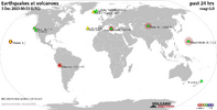
Recent quakes worldwide map shows the distribution of the last 20 large earthquakes. We see three regions that marked the most seismic activity equal to or greater than M4.5: Gulf of Aden, China, Philippines and Indonesia, as well as an isolated but significant earthquake in Hawaii.​
1701818344554.png

● M 5.4 - Mindanao, Philippines
2023-12-05 00:34:30 (UTC)
8.951°N 126.622°E. 43.7 km depth
USGS earthquake alert
● M5 1 Marihatag Philippines at 00:58:34 UTC
● M5.0 Marihatag Philippines at 01:01:09 UTC
● M5.1 Barcelona Philippines at 05:27:14 UTC
● M5.6 Mindanao Philippines at 09:10:08 UTC
● M5.4 Mindanao Philippines at 09:42:54 UTC
● M5.1 Hinatuan Philippines at 12:42:35 UTC
● M 5.8 - 66 km ENE of Aras-asan, Philippines
2023-12-05 13:36:39 (UTC)
9.126°N 126.869°E. 35.0 km depth
USGS earthquake alert
chrome_screenshot_5 dic. 2023 17_48_45 GMT-06_00.png

● M5.8 - Tibet, China
2023-12-05 08:39:10 (UTC)
35.0438°N / 88.8132°E. 10 km depth
NCS India earthquake alert

● M5.6 - 68 km northeast of Jiayuguan City, Gansu, China.
2023-12-05 00:55:23 (UTC)
40.35°N / 98.66°E. 10 km depth
KNDC Kazakhstan alert

● M5.2 - 186 km southwest of Aral, Xinjiang, China,
2023-12-05 00:49:42 (UTC)
39.5793°N / 79.4745°E. 10 km depth
KNDC Kazakhstan alert

● M5.0 - Qinghai, China,
2023-12-05 02:47:39 (UTC)
35.62°N / 91.35°E. 10 km depth
KNDC Kazakhstan alert
chrome_screenshot_5 dic. 2023 18_31_34 GMT-06_00.png

● M 5.7 - 17 km W of Talisay, Philippines
2023-12-05 08:23:55 (UTC)
13.930°N 120.462°E. 77.7 km depth
USGS earthquake alert
chrome_screenshot_5 dic. 2023 18_45_04 GMT-06_00.png

●M 5.6 - 149 km NNW of Las Khorey, Somalia
2023-12-05 07:31:33 (UTC)
12.286°N 47.443°E. 10.0 km depth
USGS earthquake alert

● M 5.4 - Gulf of Aden
2023-12-05 20:19:53 (UTC)
12.339°N 47.497°E. 10.0 km depth
USGS earthquake alert

● M 4.5 - 162 km NW of Las Khorey, Somalia
2023-12-05 06:02:25 (UTC)
12.106°N 47.053°E. 10.0 km depth
USGS earthquake alert
chrome_screenshot_5 dic. 2023 18_46_57 GMT-06_00.png

● M 5.1 - 13 km SSE of Volcano, Hawaii
2023-12-05 03:53:45 (UTC)
19.323°N 155.204°W. 1.9 km depth
USGS earthquake alert
chrome_screenshot_5 dic. 2023 18_50_57 GMT-06_00.png

● M 5.1 - Halmahera, Indonesia
2023-12-05 12:36:38 (UTC)
2.557°N 128.256°E. 67.0 km depth
USGS earthquake alert
chrome_screenshot_5 dic. 2023 18_52_25 GMT-06_00.png

● M5.0 - 239 km southwest of Apia, Tuamasaga, Samoa,
2023-12-05 18:53:35 (UTC)
15.213°S / 173.4706°W 28 km depth
EMSC earthquake alert
chrome_screenshot_5 dic. 2023 18_54_19 GMT-06_00.png

Philippine Islands region (M4.7, M4.8, M4.7, M4.5. M4.7, M4.6, M4.9, M4.8, M4.5, M4.6) Cortes Philippines (M4.7) Tidman Philippines (M4.9) Gulf of Aden (M4.7) Las Khorey, Somalia (M4.9, M4.5, M4 5, M4.9) Port Blair, India (M4.8) Hihifo, Tonga (M4.7) Guerrero Mexico (M4.2)​

● Summary

Seismic activity has been at moderate levels in the last 24 hours. This is the last chart posted by Volcanodiscovery at 22:53 UTC on December 05 Global seismic activity chart
1701817717384.png
In the past 24 hours, there were 1070 quakes of magnitudes up to 5.8:
  • 18 quakes above magnitude 5
  • 57 quakes between magnitude 4 and 5
  • 159 quakes between magnitude 3 and 4
  • 285 quakes between magnitude 2 and 3
  • 551 quakes below magnitude 2 that people normally don't feel.
Last five daysHighest record
Dec. 01 - 914 eq. Nov. 11 - 3056 eq.
Dec. 02 - 800 eq. Dec. 04 - 1192 eq.
Dec. 03 - 1056 eq.
Dec. 04 - 1192 eq.
Dec. 05 - 1070 eq.
Estimated combined seismic energy release equivalent to 50648 tons of TNT or 3.2 atomic bombs.
Volcanodiscovery
 
WORLDWIDE EARTHQUAKE REPORT DECEMBER 06_2023

Moderate levels of seismic activity occurred in the past 24h. Since we have been keeping track of the number of earthquakes occurring in 24 hours, we have not seen something as extreme as a drastic drop in the number of events. We went from 1070 earthquakes on December 5th to 395 today. Let's hope this is not a sign that something truly significant is about to happen.

The Philippine Institute of Volcanology and Seismology (Phivolcs) has reported around 1700 aftershocks following the magnitude 7.6 on December 2, 2023. The aftershocks range in magnitude from 1.4 to 6.9. Today the highest magnitude aftershock recorded in Mindanao Philippines was 5.4. The frequency of events has decreased.

So far the energy remains concentrated in the Philippine region as there is no significant response towards Indonesia, the Vanuatu region, Solomon Islands, Japan, Kamchatka Peninsula and Alaska, let alone the Americas.

For analyst Jesus Ramos there are two factors that are adding instability in the Australian plate which in turn affects the Philippine plate and these are the Ulawun volcanoes in Papua New Guinea and Merapi in Indonesia.

mapa-de-la-decada-volcanes-volcanes-dignos-de-un-estudio-particular-de-su-historia-de-erupcion...jpg
shutterstock-2209458489.png
If the energy remains concentrated in the Mindanao region of the Philippines and volcanic activity at both ends continues, this could cause a severe earthquake, i.e., at least 1 magnitude above (M8.6) of the main earthquake of 7.6 and it cannot be ruled out that in the worst case it could reach M9. So, the best that could happen is M6 or M7 earthquakes in the region of Indonesia (Sumatra, Jakarta), Malasia, Solomon Islands region and Vanuatu and northwards in the region of Japan or Kamchatka.

The total number of earthquakes recorded in the last 24 hours have decreased to 395 which is well below average. According to Volcano earthquake report no active volcano has presented more than ten earthquakes.
Cerro Bravo (1 quake mag 3.0), Clear Lake (3 quakes between mag 0.8-1.3), Coso (1 quake mag 2.4), Etna (1 quake mag 3.0), Gagak (4 quakes between mag 2.8-3.2), Kilauea (1 quake mag 2.3) Kukak (1 quake mag 3.7), Leonard Range (1 quake mag 3.6), Reykjanes (1 quake mag 1.3), Tahual (1 quake mag 3.0)
1701905772121.png

Recent quakes worldwide map shows the distribution of the last 20 large earthquakes. We see a line of light to moderate seismic activity running from the Hindu Kush to the Vanuatu region. Seismic energy continues to concentrate in the Mindanao region of the Philippines.
1701906059379.png
● M 5.3 - 31 km ESE of Marihatag, Philippines
2023-12-06 01:55:58 (UTC)
8.667°N 126.544°E. 44.1 km depth
USGS earthquake alert
● M5.2 Hinatuan Philippines at 10:41:23 UTC
● M5.4 Mindanao Philippines at 14:52:35 UTC
● M5.3 Barcelona Philippines at 15:24:40
chrome_screenshot_6 dic. 2023 18_01_53 GMT-06_00.png

● M 5.4 - Qinghai, China,
2023-12-06 17:31:48 (UTC)
35.62°N / 92.4°E. 10 km depth
Volcanodiscovery earthquake alert

● M 5.0 - 33 km southeast of Aral, Xinjiang, China
2023-12-06 08:21:31 (UTC)
40.4°N / 81.61°E. 10 km depth
USGS earthquake alert
chrome_screenshot_5 dic. 2023 18_31_34 GMT-06_00.png

● M 5.1 - eastern New Guinea region, Papua New Guinea
2023-12-06 11:17:59 (UTC)
5.596°S 147.171°E. 168.0 km depth
USGS earthquake alert

● M 5.0 - Vanuatu
2023-12-06 21:07:47 (UTC)14.721°S 167.974°E10.0 km depth
USGS earthquake alert
chrome_screenshot_6 dic. 2023 17_50_29 GMT-06_00.png

● M 5.0 - 61 km N of Claveria, Philippines
2023-12-06 06:19:13 (UTC)
19.161°N 121.033°E. 34.9 km depth
USGS earthquake alert
chrome_screenshot_6 dic. 2023 17_54_31 GMT-06_00.png

● M 5.0 - off the coast of Aisen, Chile
2023-12-06 01:58:44 (UTC)
44.245°S 78.393°W. 10.0 km depth
USGS earthquake alert
chrome_screenshot_6 dic. 2023 17_57_30 GMT-06_00.png

Other light earthquakes occurred in Philippine Islands region (M4.6, M4.7, M4.7, M4.6, M4.6, M4.9, M4.6, M4.7, M4.8, M4.9) Gulf of Aden (M4.5) Chiapas Mexico (M4.1) Colima Mexico (M4.1)

● Summary

Seismic activity has been at moderate levels in the last 24 hours. This is the last chart posted by Volcanodiscovery at 23:11 UTC on December 06 Global seismic activity chart
1701904445784.png
In the past 24 hours, there were 395 quakes of magnitudes up to 5.4:
  • 11 quakes above magnitude 5
  • 46 quakes between magnitude 4 and 5
  • 138 quakes between magnitude 3 and 4
  • 166 quakes between magnitude 2 and 3
  • 34 quakes below magnitude 2 that people normally don't feel.
Last five daysHighest record
Dec. 02 - 800 eq.Nov. 11 - 3056 eq.
Dec. 03 - 1056 eq.Dec. 04 - 1192 eq.
Dec. 04 - 1192 eq.
Dec. 05 - 1070 eq.
Dec. 06 - 395. eq.
Estimated combined seismic energy release equivalent to 16187 tons of TNT or 1 atomic bomb
Volcanodiscovery
 
Veey Strong earthquake in Vanuatu

● M 7.1 - 123 km S of Isangel, Vanuatu
2023-12-07 12:56:30 (UTC)
20.659°S 169.206°E. 48.4 km depth
USGS earthquake alert
chrome_screenshot_7 dic. 2023 08_40_05 GMT-06_00.png

Fortunately this scenario happened and is a response to the M7.6 simo in the Philippines.

So far the energy remains concentrated in the Philippine region as there is no significant response towards Indonesia, the Vanuatu region, Solomon Islands, Japan, Kamchatka Peninsula and Alaska, let alone the Americas.
If the energy remains concentrated in the Mindanao region of the Philippines and volcanic activity at both ends continues, this could cause a severe earthquake, i.e., at least 1 magnitude above (M8.6) of the main earthquake of 7.6 and it cannot be ruled out that in the worst case it could reach M9. So, the best that could happen is M6 or M7 earthquakes in the region of Indonesia (Sumatra, Jakarta), Malasia, Solomon Islands region and Vanuatu and northwards in the region of Japan or Kamchatka.
 

Magnitude 7.1 quake hits off Vanuatu, tsunami warning lifted

A 7.1 magnitude earthquake struck Thursday off the coast of the Pacific island nation Vanuatu, but a tsunami threat passed and there were no immediate reports of damage.
The offshore quake hit at 1256 GMT at a depth of 48 kilometres (30 miles), around 120 kilometres south of the town of Isangel and 340 kilometres from the capital Port Vila, the United States Geological Survey said.

“There is no longer a tsunami warning from this earthquake,” the Pacific Tsunami Warning Centre said after revising its initial assessment.

Vanuatu’s Meteorology and Geohazards Department had warned residents in the southernmost Tafea province to take “precautionary measures” such as moving from the coast to higher ground.

USGS initially reported a magnitude of 7.3 and a depth of 35 kilometres, but soon revised its report.

Earthquakes are common in Vanuatu, a low-lying archipelago of 320,000 people that straddles the seismic Ring of Fire, an arc of intense tectonic activity that stretches through Southeast Asia and across the Pacific basin.
A magnitude 6.7 earthquake struck northern Vanuatu in November, with authorities warning that “small tsunami waves” had been picked up by ocean monitoring equipment.
Vanuatu is ranked as one of the countries most susceptible to natural disasters such as earthquakes, storm damage, flooding and tsunamis, according to the annual World Risk Report.

 
Back
Top Bottom