Earthquakes around the world

Due to close relatives in Wellington, we got a message on Facebook about the quake just after it happened. The quake has now been upgraded to 7.5 by one agency and to 7.8 by USGS.

There has been quite a number of aftershocks and since it is night there are not many pictures yet. But there are some as posted by stuff.co.nz _http://www.stuff.co.nz/national/86416467/gallery-large-quake-strikes-new-zealand

Broken glass and damages seen at Wakefield St, Wellington:
1479042921301.jpg


Wellington residents evacuated from a building in Willis St:
1479042921301.jpg


The bridge at Wellington ferry terminal has collapsed.
1479042921301.jpg


Damage to the buildings on Wakefield Street, Wellington
1479042921301.jpg


Scene in a Wellington resident's home after a quake hit:
1479042921301.jpg


Farmers in Cuba St in Wellington:
1479042921301.jpg


Fresh Choice in Nelson
1479042921301.jpg


Fresh Choice Nelson
1479042921301.jpg


Shattered glasses in one of the buildings in Wellington
1479042921301.jpg
 
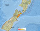
Here is a picture of the quake and aftershocks >=4.5
 

Attachments

  • Untitled.png
    Untitled.png
    627.9 KB · Views: 116
Aeneas said:
Here is a picture of the quake and aftershocks >=4.5

Hope that family and friends in N.Z. are safe, Aeneas. A possible Tsunami threat has been issued.

New Zealand's Civil Defense and Emergency Management Ministry (MCDEM) issued a warning for a tsunami for the eastern coast of both North and South Islands.

"The tsunami threat is for the east coast of all New Zealand (including Christchurch, Wellington and the Chatham islands," MCDEM twitted.
https://sputniknews.com/asia/201611131047387279-earthquake-new-zealand-magnitude/
 
angelburst29 said:
Aeneas said:
Here is a picture of the quake and aftershocks >=4.5

Hope that family and friends in N.Z. are safe, Aeneas. A possible Tsunami threat has been issued.

New Zealand's Civil Defense and Emergency Management Ministry (MCDEM) issued a warning for a tsunami for the eastern coast of both North and South Islands.

"The tsunami threat is for the east coast of all New Zealand (including Christchurch, Wellington and the Chatham islands," MCDEM twitted.
https://sputniknews.com/asia/201611131047387279-earthquake-new-zealand-magnitude/
Thank you Angelburst. It is still very early in the morning in NZ, 5:22am, so I think a clearer picture will emerge with daylight coming. The relatives are ok, 'just' rudely shaken awake.
 
As can be expected with such a large earthquakes, is a lot of 'smaller' earthquakes. So far, less than 5 hours after the initial quake, 16 aftershocks above 4.5:
17 of 82 earthquakes in map area.

5.1
46km SE of Blenheim, New Zealand
2016-11-13 15:33:03 (UTC)
14.7 km
5.0
42km SE of Blenheim, New Zealand
2016-11-13 13:49:59 (UTC)
8.0 km
6.2
12km N of Kaikoura, New Zealand
2016-11-13 13:31:27 (UTC)
10.0 km
5.3
39km SSE of Blenheim, New Zealand
2016-11-13 13:21:12 (UTC)
10.0 km
4.9
38km S of Blenheim, New Zealand
2016-11-13 13:12:30 (UTC)
20.9 km
4.9
19km N of Kaikoura, New Zealand
2016-11-13 12:52:19 (UTC)
4.9 km
5.2
29km SE of Blenheim, New Zealand
2016-11-13 12:38:38 (UTC)
19.4 km
5.2
26km W of Kaikoura, New Zealand
2016-11-13 12:37:45 (UTC)
10.0 km
5.2
51km N of Amberley, New Zealand
2016-11-13 12:25:55 (UTC)
9.6 km
4.9
23km NW of Kaikoura, New Zealand
2016-11-13 12:20:44 (UTC)
10.5 km
5.0
46km SSW of Brooklyn, New Zealand
2016-11-13 12:04:15 (UTC)
13.7 km
6.1
23km NNW of Kaikoura, New Zealand
2016-11-13 11:52:45 (UTC)
16.0 km
5.7
32km SSE of Blenheim, New Zealand
2016-11-13 11:41:49 (UTC)
10.0 km
6.5
17km NNW of Kaikoura, New Zealand
2016-11-13 11:32:07 (UTC)
10.0 km
5.8
2km NW of Kaikoura, New Zealand
2016-11-13 11:12:39 (UTC)
10.4 km
7.8
53km NNE of Amberley, New Zealand
2016-11-13 11:02:56 (UTC)
 
To add to today's quakes, which are higher than average mainly due to the aftershocks in New Zealand as noted by Aeneas, there's been strong activity in Argentina. The geomagnetic situation is 'unstable', KP index 5:

1 Day, Magnitude 2.5+ Worldwide
43 earthquakes

6.2 [just downgraded to 5.7]
26km N of Chilecito, Argentina
2016-11-13 14:01:00 (UTC)
100.6 km

us100077ap_ciim.jpg


5.7
24km E of Tinogasta, Argentina
2016-11-13 01:01:51 (UTC)
121.0 km

5.2
106km NNE of Chignik Lake, Alaska
2016-11-12 21:52:36 (UTC)
11.4 km

4.2
214km S of Punta de Burica, Panama
2016-11-12 20:51:07 (UTC)
10.0 km

5.0
209km SSE of Punta de Burica, Panama
2016-11-12 20:08:48 (UTC)
10.0 km
 
RT also reports an earthquake in Italy which has been hit badly lately.
17:21 GMT
4.2 earthquake hits central Italy

Central Italy has been struck by a 4.2 magnitude earthquake, the Italian National Institute of Geophysics and Volcanology said. According to the scientists, the epicenter of the quake was located about 109 kilometers away from Rome, in a Maltignano region, and at a depth of 10 meters. There have been no reports about any casualties or damage so far.
 
Oy, no! There was a 4.2 yesterday, always on the same 'crater' in center Italy, 10Km depth, as usual.
 
There was a 7.5 earthquake early this morning which hit Kaikoura in the South Island and affected Wellington as well. A tsunami warning was issued although it has now been downgraded. Originally it was predicting a 5 metre tsunami for the east coast of the south island. Inter island ferries are cancelled. Trains in the Wellington area are cancelled. There has been extensive road damage around Kaikoura including a huge slip closing a road tunnel.

To date, there have been 2 deaths reported.

More here:
http://www.nzherald.co.nz/nz/news/article.cfm?c_id=1&objectid=11747533
 
6.3 magnitude earthquake hit north-east Philippines

A 6.3 magnitude earthquake struck the north-east Philippines on Sunday, the European Mediterranean Seismological Centre (EMSC) said. The tremors were recorded at 11:40 UTC, with the epicenter of the quake located 62 kilometers north of the island of Jomalig and a depth of 10 kilometers. There have so far been no reports of casualties or destruction. A tsunami warning was not issued. The Philippine archipelago is part of the Ring of Fire in the Pacific Ocean, which is the most seismically active region on the planet due to the colliding tectonic plates. In 1990, a 7.8 magnitude quake took the lives of 1,600 people in the Philippines.

Source: RT
 
Two deaths due to this mornings earthquake in New Zealand, one was when a homestead collapsed on them the other a heart attack at the time of the quake.
After shocks have continued through the day.
This quake very unusual as it was felt as far north as Auckland city.
Where I am in the central north island someone lost 2 feet of water in their swimming pool due to the water sloshing around. It went on for quite a while.
Me I slept through the whole thing. Out cat seems a bit stressed this morning though.
 
This is super interesting,
Flashes of light observed in Wellington. This is an excerpt from this article.
http://www.stuff.co.nz/national/86420960/earthquake-strange-glowing-in-the-sky-possibly-earthquake-lightning


With "earthquake light", the phenomenon is also notoriously difficult to observe, study, and measure.​
Ad Feedback

GNS seismologist Caroline Holden said there were anecdotal reports of lights in the sky.

"Unfortunately, we cannot measure this phenomena or its extent with our instruments to provide a clear explanation," she said.

The phenomenon has been documented for centuries.

Hypotheses have suggested the movement of rocks could generate an electric field, others suggest quakes can lead to rocks conducting electromagnetic energy and a subsequent build up of electric charges in the upper atmosphere.

Yet another theory suggests a link between the electric charge, or current, released by the earth ripping and buckling below the surface, and the magnetic properties of rock.

The charge appears as light, so the theory goes.

People reported similar strange lights in the sky during the 2011 Christchurch earthquake.

In 1888, before a large quake around the Hanmer region, a strange glow in the sky was reported by observers.

One recent study documented hundreds of sightings of strange light, glowing, and aurora-like reports, from 1600 to the 19th century.

The study in the Seismological Research Letters suggested a charge builds up in rock inside the Earth's crust and, as it becomes rapidly unstable in a quake, expands outward.

In an earthquake, the electrical charge transfers from below the surface to the surface, or above, depending on the conductivity of the rock - appearing as light.

"When such an intense charge state reaches the Earth's surface and crosses the ground–air interface, it is expected to cause [an electric transmission and breakdown] of the air and, hence, an outburst of light.

"This process is suspected to be responsible for flashes of light coming out of the ground and expanding to considerable heights at the time when seismic waves from a large earthquake pass by."

The study said some seismologists also think the theory could account for other phenomena, such as changes to electrical fields, strange fog, haze, clouds, and low-frequency humming or radio frequency emission.

In the study, the researchers found the light was more often associated with a type of quake in which tectonic plates are wrenched apart, known as a "rift" earthquake.
 

Trending content

Back
Top Bottom