Earthquakes around the world

EARTHQUAKE REPORT JUL 09

People on social networks reported an earthquake in Germany. The unusual earthquake had a magnitude of 4.2 and occurred at 11:47 UTC on July 09.


The rest of the day was characterized by low and medium magnitude earthquakes. The strongest earthquake was M5.4.

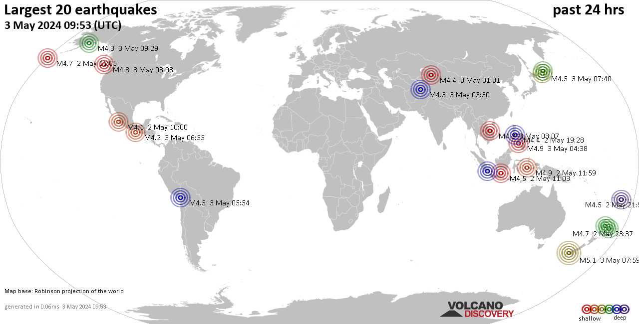
▪︎M 5.4 - Kermadec Islands region
2022-07-09 07:39:54 (UTC)
27.965°S 176.545°W
10.0 km depth

▪︎M5.2 - south of Java, Indonesia
2022-07-09 02:53:46 UTC
Depth: 52.9km

▪︎M5 - 203 km W of Abepura, Indonesia
2022-07-09 03:06:06 UTC
Depth: 61.49km

Quakes in the past 24 hours:

▪︎3 quakes above magnitude 5
▪︎38 quakes between magnitude 4 and 5
▪︎110 quakes between magnitude 3 and 4
▪︎225 quakes between magnitude 2 and 3
▪︎343 quakes below magnitude 2 that people normally don't feel.
▪︎719 quakes past 24 h. (805 earthquakes in the 24 hours prior to this report) Estimated combined seismic energy released: 2.6 x 10¹³ joules (7.31 gigawatt hours, equivalent to 6291 tons of TNT or 0.4 atomic bombs!)

 
Last week saw 3 M6 earthquakes, all of them M6.0 with two in Iran and one in the Philippines.
In the usual area, there were 1 out of 80 earthquakes worldwide equal to or greater than 4.5 and 1518 out of 1945 quakes of all sizes.
Percentage: 78.0%
Last week saw no earthquakes reaching M6.
In the usual area, there were 3 out of 125 earthquakes worldwide equal to or greater than 4.5 and 1617 out of 2111 quakes of all sizes.
Percentage: 76.6%
Earthquakes 7 days to July 10th 2022.gif
 
EARTHQUAKE REPORT PAST 24HRS

In the past 24 hours only one M5 earthquake has been recorded.

M 5.6 - Mariana Islands region (Originally recorded as M5.9 and later updated by USGS) 2022-07-10 22:19:59 (UTC)
18.772°N 147.046°E. 10.0 km depth

The rest of the day has been characterized by low magnitude earthquakes in the usual places around the Ring of Fire, it is worth mentioning that the seismic swarm in Puerto Rico has returned. 40 earthquakes have been recorded in the past 24 hours in the Puerto Rico region

▪︎2 quakes above magnitude 4
▪︎14 quakes between magnitude 3 and 4
▪︎21 quakes between magnitude 2 and 3
▪︎3 quakes below magnitude 2 that people normally don't feel.

Strongest earthquake M 4.5 - 73 km N of Culebra, Puerto Rico 2022-07-10 03:47:09 (UTC) 18.967°N 65.228°W. 24.0 km depth

Quakes in the past 24 hours:

▪︎Global seismic activity level: Low
▪︎1 quake above magnitude 5
▪︎32 quakes between magnitude 4 and 5
▪︎103 quakes between magnitude 3 and 4
▪︎262 quakes between magnitude 2 and 3
▪︎425 quakes below magnitude 2 that people normally don't feel.
▪︎823 quakes past 24 h. (718 earthquakes in the 24 hours prior to this report) Estimated combined seismic energy released: 2.7 x 10¹³ joules (7.38 gigawatt hours, equivalent to 6352 tons of TNT or 0.4 atomic bombs!)

 
Two strong earthquakes in Vanuatu

M 5.7 - 88 km ESE of Port-Vila, Vanuatu
2022-07-11 21:06:04 (UTC)
18.132°S 169.037°E
10.0 km depth

M 6.1 - 87 km SE of Port-Vila, Vanuatu
2022-07-11 21:10:49 (UTC)
18.186°S 168.996°E
10.0 km depth

Estimated seismic energy release
8.9 x 10¹³ joules (24.8 gigawatt hours, equivalent to 21301 tons of TNT or 1.3 atomic bombs!)
 
EARTHQUAKE REPORT PAST 24HRS

Tsunami statement issued after M6.1 earthquake in Vanuatu

TSUNAMI INFORMATION STATEMENT NUMBER 1 NWS PACIFIC TSUNAMI WARNING CENTER HONOLULU HI 1131 AM SST MON JUL 11 2022
EVALUATION ---------- * AN EARTHQUAKE WITH A PRELIMINARY MAGNITUDE OF 6.0 OCCURRED ABOUT 96 MILES SOUTHWEST OF UPOLU ISLAND AT 1124 AM SST ON MONDAY JULY 11 2022. * BASED ON ALL AVAILABLE DATA... THERE IS NO TSUNAMI THREAT TO AMERICAN SAMOA FROM THIS EARTHQUAKE. * SOME AREAS MAY HAVE EXPERIENCED VERY STRONG SHAKING. POTENTIAL IMPACTS ----------------- * NO TSUNAMI IMPACTS ARE EXPECTED. Tsunami information center
Definition of bulletins
Tsunami Warning - A tsunami warning is issued when a tsunami with the potential to generate widespread inundation is imminent, expected, or occurring. Warnings alert the public that dangerous coastal flooding accompanied by powerful currents is possible and may continue for several hours after initial arrival. Warnings alert emergency management officials to take action for the entire tsunami hazard zone. Appropriate actions to be taken by local officials may include the evacuation of low-lying coastal areas, and the repositioning of ships to deep waters when there is time to safely do so. Warnings may be updated, adjusted geographically, downgraded, or canceled. To provide the earliest possible alert, initial warnings are normally based only on seismic information.

Tsunami Advisory - A tsunami advisory is issued when a tsunami with the potential to generate strong currents or waves dangerous to those in or very near the water is imminent, expected, or occurring. The threat may continue for several hours after initial arrival, but significant inundation is not expected for areas under an advisory. Appropriate actions to be taken by local officials may include closing beaches, evacuating harbors and marinas, and the repositioning of ships to deep waters when there is time to safely do so. Advisories are normally updated to continue the advisory, expand/contract affected areas, upgrade to a warning, or cancel the advisory.

Tsunami Watch - A tsunami watch is issued to alert emergency management officials and the public of an event which may later impact the watch area. The watch area may be upgraded to a warning or advisory - or canceled - based on updated information and analysis. Therefore, emergency management officials and the public should prepare to take action. Watches are normally issued based on seismic information without confirmation that a destructive tsunami is underway.

Tsunami Information Statement - A tsunami information statement is issued to inform emergency management officials and the public that an earthquake has occurred, or that a tsunami warning, watch or advisory has been issued for another section of the ocean. In most cases, information statements are issued to indicate there is no threat of a destructive tsunami and to prevent unnecessary evacuations as the earthquake may have been felt in coastal areas. An information statement may, in appropriate situations, caution about the possibility of destructive local tsunamis. Information statements may be re-issued with additional information, though normally these messages are not updated. However, a watch, advisory or warning may be issued for the area, if necessary, after analysis and/or updated information becomes available. Tsunami Information Center

▪︎Moderate earthquake M 5.6 - 101 km NNE of Hihifo, Tonga
2022-07-11 22:23:36 (UTC)
15.163°S 173.325°W. 10.0 km depth

M 4.6 - 19 km NNW of Baikunthpur, India
2022-07-11 02:40:02 (UTC)
23.425°N 82.493°E. 10.0 km depth8

▪︎M 4.7 - 19 km WSW of Metsavan, Armenia
2022-07-11 03:36:23 (UTC)41.148°N 44.007°E10.0 km depth

▪︎M 4.5 - 25 km ENE of Kīsh, Iran
2022-07-11 17:16:50 (UTC)
26.634°N 54.263°E. 10.0 km depth

Earthquakes past 24 hours

▪︎1 quake above magnitude 6
▪︎4 quakes between magnitude 5 and 6
▪︎35 quakes between magnitude 4 and 5
▪︎89 quakes between magnitude 3 and 4
▪︎231 quakes between magnitude 2 and 3
▪︎445 quakes below magnitude 2 that people normally don't feel.
▪︎805 quakes past 24 h. (823 earthquakes in the 24 hours prior to this report) Estimated combined seismic energy released: 1.2 x 10¹⁴ joules (32.5 gigawatt hours, equivalent to 27949 tons of TNT or 1.7 atomic bombs)

Earthquake report past 24h
 
Strong earthquakes southeast Pacífic Ocean

M 5.8 - 125 km NE of Hihifo, Tonga
2022-07-12 00:35:05 (UTC)
15.217°S 172.908°W. 10.0 km depth

M 5.7 - 145 km SSW of Gataivai, Samoa
2022-07-12 02:04:53 (UTC)
15.049°S 172.711°W. 10.0 km depth

Unusual earthquake M 4.6 - 46 km SSW of Mufumbwe, Zambia
2022-07-12 02:11:38 (UTC)
14.070°S 24.630°E. 10.0 km depth
 
EARTHQUAKE REPORT PAST 24HRS

A second aftershock was recorded in the Easter Islands after the 6.8 magnitude earthquake (according to USGS).

M 5.5 - Easter Island region
2022-07-12 21:47:57 (UTC)
22.472°S 114.049°W. 10.0 km depth

The earthquake M6.8 had a estimated release seismic energy of 1 x 10¹⁵ joules (278 gigawatt hours, equivalent to 2.4 x 10⁵ tons of TNT or 14.9 atomic bombs!) There were different reports of the magnitude of the earthquake.

chrome_screenshot_1657671738029.png

Strong earthquake M5.5 - 14 km WSW of La Capilla, Peru. 2022-07-12 23:36:11 (UTC)
16.783°S 71.310°W. 10.0 km depth

Quakes in the past 24 hours:

▪︎1 quake above magnitude 6
▪︎8 quakes between magnitude 5 and 6
▪︎39 quakes between magnitude 4 and 5
▪︎91 quakes between magnitude 3 and 4
▪︎202 quakes between magnitude 2 and 3
▪︎487 quakes below magnitude 2 that people normally don't feel.
▪︎828 quakes past 24 h. (805 earthquakes in the 24 hours prior to this report) Estimated combined seismic energy released: 1.1 x 10¹⁵ joules (311 gigawatt hours, equivalent to 2.7 x 10⁵ tons of TNT or 16.7 atomic bombs!)
Earthquake report past 24h
 
EARTHQUAKE REPORT PAST 24HRS

Current Global seismic activity is moderate. The strongest earthquake occurred in Peru, with a magnitude of 5.1

M 5.1 - 32 km NNE of Cocachacra, Peru
2022-07-13 16:05:29 (UTC)
16.846°S 71.594°W. 17.7 km depth

Previous to the magnitude 5.1 M 5.0 - 31 km NE of Cocachacra, Peru. 2022-07-13 09:13:34 (UTC) 16.902°S 71.537°W.
21.6 km depth

Other earthquakes

M 5.0 - 141 km W of Valparaíso, Chile
2022-07-13 21:21:29 (UTC)
33.238°S 73.123°W. 10.0 km depth

Quakes in the past 24 hours:
▪︎4 quakes above magnitude 5
▪︎31 quakes between magnitude 4 and 5
▪︎109 quakes between magnitude 3 and 4
▪︎220 quakes between magnitude 2 and 3
▪︎468 quakes below magnitude 2 that people normally don't feel.
▪︎832 quakes past 24 h. (828 earthquakes in the 24 hours prior to this report) Estimated combined seismic energy released: 1.9 x 10¹³ joules (5.33 gigawatt hours, equivalent to 4584 tons of TNT or 0.3 atomic bombsi)

 
M 5.4 - 35 km WNW of Güiria, Venezuela
2022-07-14 19:16:58 (UTC)
10.701°N 62.597°W
108.6 km depth
(USGS)

Earthquake of magnitude 5.5 that was registered with epicenter 9 km northeast of Irapa. The tremor was felt in cities such as: Cumaná, Carúpano, in #Sucre; Maturín, in #Monagas and Anaco, in #Anzoátegui, eastern sectors of Venezuela.
 
EARTHQUAKE REPORT PAST 24HRS

After the M5.7 earthquake in Venezuela, an earthquake was registered in Ecuador with a preliminary magnitude of 6.0, later the earthquake would be updated to M5.7 by USGS.

▪︎M 5.7 - 12 km SW of Samborondón, Ecuador
2022-07-14 22:30:12 (UTC)
2.040°S 79.811°W. 73.0 km depth

Some videos were posted on Twitter of this strong earthquake in Ecuador. In the following video during the earthquake, people pray and implore the Lord for mercy.

People were evacuated from markets and shopping centers.

Another strong earthquake ocurred in Vanuatu (strongest in the last 24 hours)

▪︎M 5.8 - 15 km W of Port-Olry, Vanuatu
2022-07-14 17:50:27 (UTC)
15.047°S 166.930°E. 21.8 km depth

Moderate earthquake in California
▪︎M 4.6 - 13km NE of Ridgecrest, CA
2022-07-15 01:19:06 (UTC)
35.708°N 117.579°W. 6.5 km depth

Quakes in the past 24 hours:
▪︎Global seismic activity level: Moderate
▪︎7 quakes above magnitude 5
▪︎31 quakes between magnitude 4 and 5
▪︎125 quakes between magnitude 3 and 4
▪︎227 quakes between magnitude 2 and 3
▪︎419 quakes below magnitude 2 that people normally don't feel.
▪︎809 quakes past 24 h. (832 earthquakes in the 24 hours prior to this report) Estimated combined seismic energy released: 8.6 x 10¹³ joules (24 gigawatt hours, equivalent to 20649 tons of TNT or 1.3 atomic bombs!)

 
EARTHQUAKE REPORT PAST 24HRS

Maybe it is a coincidence or maybe not. In Japan there is a belief that the appearance of a rowing fish is the announcement of an upcoming earthquake of great magnitude.

They captured rowing, the fish that announces earthquakes and other catastrophes
Specific, the oarfish is considered in Japan as Ryugu no tsukai, which means “Messenger of the Palace of the God of the Sea”. This means that if several rowing fish are seen in the Asian country, the occurrence of powerful earthquakes is close.
The appearance of saber fish is associated in Japanese culture with the announcement of the occurrence of violent earthquakes and tsunamis. Although it is a popular belief, the sighting of them in recent years has preceded earthquakes in various parts of the world.
In July 2020 they found one in Alaska, where a few days later an earthquake of 7.8 degrees was recorded. Meanwhile, in June of that same year in Mexico An earthquake of 7.5 degrees was recorded 10 days after the strange animal appeared.
From science they advance a possible explanation for the appearance of the oarfish and the earthquakes: deep-sea fish such as oarfish live near the sea floor and are much more sensitive to active fault movements than those near the sea surface. This would make them emerge when they detect strange movements, which alter their behaviors.

Four days ago in Arica, Chilean fishermen captured a 3 meter oarfish

Two days ago peruvian fishermen hunt a sablefish or oarfish of more than five meters in Pucusana

Today Friday, Jul 15 at 19:37 UTC a very strong mag. 6.4 earthquake hit the South Pacific Ocean off the coast of Chile. Far south of where the oarfish were found, however, it does not cease to amaze people on social media.

The estimated seismic energy release of this M6.4 was equivalent to 60036 tons of TNT or 3.8 atomic bombs according to Volcanodiscovery data.

The past 24 hours have been characterized by mostly low magnitude earthquakes. Of note were a 4.7 magnitude earthquake in Pakistan and a 5.1 magnitude earthquake in Tonga.

▪︎M 4.7 - 37 km E of Dera Bugti, Pakistan
2022-07-15 22:22:13 (UTC)
29.085°N 69.541°E. 10.0 km depth

▪︎M 5.1 - south of the Fiji Islands
2022-07-15 21:27:25 (UTC)
23.026°S 176.980°W. 135.7 km depth

Quakes in the past 24 hours:

▪︎1 quake above magnitude 6
▪︎1 quake between magnitude 5 and 6
▪︎38 quakes between magnitude 4 and 5
▪︎120 quakes between magnitude 3 and 4
▪︎251 quakes between magnitude 2 and 3
▪︎481 quakes below magnitude 2 that people normally don't feel.
▪︎892 quakes past 24 h. (809 earthquakes in the 24 hours prior to this report) Estimated combined seismic energy released: 2.7 x 10¹⁴ joules (74.4 gigawatt hours, equivalent to 64000 tons of TNT or 4 atomic bombs)


▪︎Earthquake Forecast. This forecast was published 4 hours before the M6.4 earthquake in Chile. Possibly it is this earthquake. Let's hope it is, however, we must be alert in case a major earthquake occurs in the next few days.

 
EARTHQUAKE REPORT PAST 24HRS

Global Seismic activity level (based on the averages of all earthquakes during a given time interval) in the last 24 hours was moderate
Global seismic activity chart

Two M5+ earthquakes in the Kermadec Islands within minutes of each other.

M 5.2 - south of the Kermadec Islands
2022-07-16 18:04:03 (UTC)
32.323°S 178.103°W
10.0 km depth

M 5.3 - south of the Kermadec Islands
2022-07-16 18:08:08 (UTC)
32.273°S 178.168°W
10.0 km depth

M 5.3 - 151 km SSW of Lata, Solomon Islands
2022-07-16 07:50:50 (UTC)
12.056°S 165.490°E. 9.4 km depth

Quakes in the past 24 hours:

▪︎6 quakes above magnitude 5
▪︎50 quakes between magnitude 4 and 5
▪︎109 quakes between magnitude 3 and 4
▪︎256 quakes between magnitude 2 and 3
▪︎452 quakes below magnitude 2 that people normally don't feel.
▪︎873 quakes past 24 h. (892 earthquakes in the 24 hours prior to this report) Estimated combined seismic energy released: 5.3 x 10¹³ joules (14.8 gigawatt hours, equivalent to 12692 tons of TNT or 0.8 atomic bombs!)

Earthquake report past 24h

▪︎Earthquake Forecast 14-19 july video
 
Last week saw no earthquakes reaching M6.
In the usual area, there were 3 out of 125 earthquakes worldwide equal to or greater than 4.5 and 1617 out of 2111 quakes of all sizes.
Percentage: 76.6%
In the last week there were 3 M6 worldwide, the highest being a M6.8 in the Eastern Island region.
In the usual area, there were 3 out of 99 earthquakes worldwide equal to or greater than 4.5 and 1618 out of 2028 quakes of all sizes.
Percentage: 79.8%
Earthquakes 7 days to July 17th 2022.gif
 
Back
Top Bottom