Earthquakes around the world

Oct 16, 2019


Oct 15, 2019


Published 5 hours ago

SAN JOSE, Calif. - This week’s earthquakes have some people in the Bay Area understandably feeling uneasy. A seismologist with the USGS said the earthquakes in San Benito County and Contra Costa are not connected.

Tuesday’s quake registered at 4.7 north of San Juan Bautista on the San Andreas fault. Monday night’s quake registered at 4.5 north of Walnut Creek between the Concord and Calaveras faults.

“Earthquakes occur somewhat randomly,” said Annemarie Baltay, a seismologist with the USGS. “It’s just a statistical chance that occurred within 14 hours of each other.”

Baltay said there’s a less than two percent chance the earthquakes could lead to a bigger quake. She’s focused on ShakeAlert. It’s an early warning system that gives seconds notice of when an earthquake has begun.

“If you are in bed, we recommend you pull a pillow over your face so that you don't get cut on your face,” said Baltay.
Seismologists forecast a big earthquake by 2043. Baltay said there’s a 72 percent chance of a 6.7 magnitude or greater earthquake likely rupturing the Hayward fault.

“This afternoon's was a gentle roll compared to last night’s which was compared to more of a jerk,” said Frances Herbert who felt both earthquakes. She’s actually grateful for the small quakes.

“Hopefully they relieve some pressure so we don’t have the bigger one happen to us,” said Herbert.

“If everything is in rubble and the first responders can't get to us, we need to be self-sufficient,” said Patty Eaton of the Santa Clara Office of Emergency Management.

County officials recommend an emergency go-bag with important documents and an emergency kit with a tool to turn off your gas, a mini survival kit and a crank radio.

“It was a bit traumatic for me and my mother couldn't get to me because the streets were buckled,” said Herbert.

For Herbert, she was six years old when Loma Prieta happened. She realizes she's not as prepared as she’d like to be.

“We need to get it together and get that out-of-state contact arranged and our bags packed,” said Herbert.

Baltay said the beta version of the ShakeAlert system performed well as it was designed. For both earthquakes, an alert was issued to beta users five seconds after the quake.


Last edited:
Screenshot-2019-10-16-at-14.34.32.jpg


It's a good possibility, the failure of a component within the holding tanks infrastructure may have a relationship with the seismic data history.
Everything has a resonance frequency or a mechanical resonance. The Nustar Fire fuel storage tanks may have found theirs.


Investigators Comb Through Evidence At NuStar Facility To Find Cause Of Fire
As the sun set on the NuStar facility in Crockett, crews were busy mopping up and preventing another potential disaster by venting adjacent tanks damaged by Tuesday’s inferno. Steve Hill with Contra Costa County Fire says, “We are confident that at this point there is no longer any threat of ignition.” Andrea Nakano reports. (10-16-2019)


September 11, 2014 7-8 minute Read:
My rides along Amtrak California’s Capitol Corridor now include an eerie stretch where they pass the site at which the highest ground motions in the Napa earthquake were recorded mere weeks ago. Just at the south abutments of the I-80 bridges over the Carquinez Strait, where the Union Pacific tracks pass through the C&H refinery, a shallow borehole seismometer recorded an acceleration of 0.99g, nearly the full force of gravity lurching soil and structures from south to north.

A Capitol Corridor train passes the site of the strongest shaking record from the Napa earthquake. Clearly seismic measurements here have big implications for a lot of infrastructure. Photo © Hunter Lohse, from www.railpictures.net

The extreme magnitude of this acceleration is a local anomaly, with the next highest recorded accelerations being ~0.66g in downtown Napa, where heavy damage was concentrated. We know that in between these official seismic stations, accelerations exceeded 1g where, for example, sidewalk slabs were overthrown. The formal strong motion records are accessible through a web database maintained by the USGS and the California Geological Survey: the Center for Engineering Strong Motion Data.

The South Napa Earthquake was the strongest to hit the region in over two decades, so, as the CESMD staff explain,
“Many structures and sites have been instrumented since then, so this is the first set of significant data for many of these stations. The [newly instrumented] structures include the major Caltrans toll bridges in the Bay Area, for which Caltrans also supported installation of geotechnical (downhole) arrays.”
Indeed many significant new structures throughout the Bay Area (notably, large residential towers on Rincon Hill and the new eastern span of the Bay Bridge) got their first recorded response to significant ground motion during this 6.0 quake. These data allow engineers to calibrate and validate their models of structural response in order to verify how their seismic designs work, or to identify potentially compromised structures quickly following an earthquake.


Added reference direction of the 4.5 with a Depth @ 13.97 km (8.7 miles)
946fe2be1dc47172976c5aed56992b3c.png


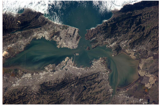
Astronaut’s-eye view of the bridges around San Francisco Bay. Golden Gate top center, Carquinez across strait in bottom right quadrant. Napa quake epicenter at lower right corner of frame. Photo via astronaut Rick Mastracchio

The Carquinez Strait site of highest recorded ground motions, above which Amtrak whizzes 36 times a day–and so do over 100,000 cars, offers a perfect illustration of seismic design and structural response. In addition to borehole seismometers on the south shore capturing the “ground truth” of shaking at the site, both the eastbound and westbound interstate highway bridges soaring above are heavily instrumented to gauge structural response to ground-shaking.

Plan and elevation view of seismic instrumentation on the westbound Carquinez suspension bridge

Notably, the westbound interstate lanes cross a brand new suspension bridge, completed in 2003 to replace a 1929 steel truss structure whose 1958 twin still carries the eastbound lanes. The differences among the accelerometer records from the ground, the 56-year-old metal truss bridge, and the 10-year-old suspension bridge are illuminating, and apparent even to a non-expert.

The site is 19 km from the epicenter. On the ground, the quake here was sharp, impulsive, and relatively short. The P-wave is strong, and the S wave follows by just over two seconds, yanking the instruments northward. High amplitude shaking lasts around 5 seconds then trails off.


Center for Engineering Strong Motion Data – record from site of highest recorded shaking (99%g) in Aug 24 M6.0 South Napa earthquake

On the metal truss bridge (accelerogram below), this motion is channeled into a dominant frequency as the bridge resonates. Here on the bridge, perceptible shaking lasts two to three times as long as it does on the ground below. There’s still a lot of ragged, high-frequency motion apparent at all positions along the bridge because the rattly metal structure’s small, stiff components transmit that original high-frequency energy from the ground. Amplitudes are consistently higher at the tops of the towers (channels 8, 23) and at midspan (channel 34) than they are on the piers and abutments (channels 6, 13, 32). For a really fascinating detailed look at how the structure responded, match the channels labeled here with this diagram of the instruments on the bridge.


Carquinez eastbound bridge Napa quake response

The suspension bridge is a whole different beast. Shaking starts strongly and abruptly with the P-wave, and by the time the S-wave ripples through (top two records, channels 54 and 74, show stations on bridge elements mounted firmly in the ground, and thus closely resemble the “ground truth” shaking), the bridge is already beginning to oscillate. Here, the structural resonance is strong and profoundly apparent… and it lasts for at least 40 seconds. Two dominant frequencies appear (more may be evident with more quantitative analysis than this cursory visual inspection), but you can see especially in the displacement records (e.g., channel 35 displacement) the main 1 Hz signal as well as another ~0.2 Hz (5 seconds per cycle) that shows up toward the end. You would feel this as strong, rhythmic bouncing for quite some time. Spooky!


Carquinez westbound bridge structural response to Napa earthquake. Note very periodic oscillation, and anticorrelation between E and W sides of bridge

One noteworthy feature of these suspension bridge records is the exact anticorrelation between the east and west sides of the bridge deck in the middle of the main span. Compare channels 35 & 39, or 32 & 33. As the west side moves down, the east side moves up. This pattern represents torsion of the bridge, which was illustrated notoriously in the failure of the Tacoma-Narrows bridge (the infamous Galloping Gertie), and in the less well known but very impressive Ibañez Suspension Bridge’s response to a M6.0 quake in Puerto Aysen, Chile:


This CESMD database can be accessed through an interactive map of strong motion records throughout the Bay Area from sites where shaking exceeded 0.5%g. Engineers will be well aware of this site, but I find it fascinating and useful to check out how shaking would have felt at various sites, in various buildings, and at various heights around the Bay Area. Have a look around the map for shaking records in your neighborhood, or pick your favorite iconic Bay Area structure and see how it “performed.”
Interactive Map of Strong Motion Stations for M6.0 South Napa Earthquake


Dr. Lucy Jones @DrLucyJones Today's M4.8 near Hollister is too far from yesterday's M4.5 to be connected. When we look for patterns between quakes at long distances, we see triggering for ~3x length of the fault. The fault length in a M4.5 is less than 1 k
10:05 PM · Oct 15, 2019
 
Southern California Earthquake....The Big one coming soon? New article released today..
Oct 18, 2019
A major California fault capable of producing a magnitude 8 earthquake has begun moving for the first time on record, a result of this year’s Ridgecrest earthquake sequence destabilizing nearby faults, Caltech scientists say in a new study released in the journal Science on Thursday


LOS ANGELES (KABC) --
A 3.7-magnitude earthquake hit the Compton area early Friday morning, according to the U.S. Geological Survey.

The quake hit around 12:20 a.m. and had a depth of 14 miles. According to the USGS, the quake hit 1.5 miles west of East Rancho Dominguez and 2.4 miles south-southwest of Lynwood.

People felt shaking in Orange County and parts around Los Angeles, including in the San Fernando Valley, East L.A. and Norwalk, the USGS said.

It is unclear if the earthquake caused any damage or injuries. A tweet from the Los Angeles Police Department's Communications Division said there had been "no impact at the LAPD Dispatch Centers" following the earthquake.

The quakes comes as millions of residents statewide participated in the Great California Shakeout earthquake drill on Thursday, the 30th anniversary of the magnitude 6.9 Loma Prieta quake that shook the Bay Area in 1989.

Hours before the Compton area was hit, a 3.8-magnitude temblor struck near Ridgecrest, which was where two powerful earthquakes hit in July.


Landslide, building damage from Philippine quake kills 4
1802371-1627122465.jpg

1 / 3
Debris are scattered on the floor of a damaged store a day after a strong quake struck in Digos, Davao del Sur province, southern Philippines on Wednesday night. (AP Photo)
1802376-692487268.jpg

2 / 3
Damaged walls are seen on a building a day after a strong quake struck in Digos, Davao del Sur province, southern Philippines on Wednesday night. (AP Photo)
1801656-121662790.jpg

3 / 3
People are seen receiving assistance outside Kidapawan Doctors Hospital in Kidapawan City, after an earthquake, in Kidapawan City, Philippines. (Reuters)

October 16, 2019 - DAVAO, Philippines: A strong and shallow 6.4-magnitude quake hit the southern Philippines on Wednesday,
the United States Geological Survey (USGS) said, sending hundreds rushing out of a shopping mall where local television said killing at least one child and injuring more than two dozen other people.

The USGS said the quake, which was 14 kilometers (8.6 miles), struck 69 km (43 miles) north-northwest of the city of General Santos, Mindanao at 7:39 p.m. (1137 GMT). The epicenter was about 80 km southwest of central Davao.

Five dead from strong quake in southern Philippines
1803261-1628248939.jpg

Residents stand near a crack caused by a 6.4 magnitude earthquake near the town of Magsaysay. Three children were among four people killed after the powerful earthquake hit the southern Philippines. (AFP)

More than 200 aftershocks from the 6.3 magnitude tremor have also been recorded.

Another 5.3 magnitude quake rocked Davao Oriental around 4:53 a.m. on Thursday.

October 17, 2019 - MANILA: Five people were reported killed and dozens injured after a strong 6.3 magnitude earthquake struck southern Philippines Wednesday evening, sending people scurrying out of their residences, buildings and shopping malls.

Information released by the Philippine Institute of Volcanology and Seismology (Phivolcs) showed the shallow quake of tectonic origin occurred 7:37 p.m. 22 km southeast of Tulunan town in North Cotabato.

It was felt at intensity 7, described as destructive under the Phivolcs Earthquake Intensity Scale (PEIS), in Kidapawan City, and in Tulunan and M’Lang towns, North Cotabato.

Intensity 6 was reported in Digos City, Davao Del Sur; Sto. Niño, South Cotabato; and Tacurong City.

President Duterte’s home city of Davao experienced intensity 5, as well as, in Alabel and Malungon, Sarangani; Lake Sebu, Palomok, Tampakan and Tupi in South Cotabato; Koronadal City; Roxas and Pikit in North Cotabato; General Santos (GenSan) City; and Kalamansig, Lebak and Palimbang, Sultan Kudarat.
 
5.6-Magnitude Earthquake Jolts Southern Iran - Reports
21.10.2019
At the moment there is no official information about casualties or damage caused by the natural disaster. The quake was also reported in nearby Dubai.

According to the Fars news agency, a tremor hit the southern part of the Islamic Republic on Monday. Preliminary reports suggest that the epicentre of the earthquake was located at a depth of 2 km in Hormozgan Province near the cities of Kukherd and Bandar Lengeh.

The country is located on major seismic faults and often experiences earthquakes, including powerful ones in Iran's South.

 
6.0-Magnitude Earthquake Hits Near Shores of Samoa - USGS
22.10.2019
The island nation is situated in the Ring of Fire - a seismically active area in the Pacific Ocean, where powerful earthquakes and volcano eruptions are common.

According to the United States Geological Survey (USGS), a 6.0-magnitude tremor struck off Samoa Tuesday morning. The epicentre of the quake is located at a depth of 89 kilometres (55 miles), about 169 km (105 miles) southwest of the capital city of Apia.

There are no official reports on casualties at the moment, and the authorities haven't issued a tsunami alert.


DETAILS TO FOLLOW
 
Is this reported incidence of burning sewers in California a result of the small earthquakes?
Or is it because all hell is about to break loose?
"Fires Are Being Reported Underground In California. This Is Northern California Around Where Last Years PARADISE FIRES "
These event also don't abide by the fire regulations if they happen in a dry period.
 
Is this reported incidence of burning sewers in California a result of the small earthquakes?

This is near Porter Ranch which is/was on fire.
I think this video is misleading and the bit is taken out of context because what is shown next is footage of the surroundings being on fire (I saw the original video but now I can't locate it).

This looks like it's a storm drain (drain/pipes that handle water run-off) and there's probably leafy debris in there that caught on fire from embers being sent out very far.
Embers travel very far in certain conditions. (documented in real fire conditions and in a research settings)

It certainly is odd but this seems like a logical explanation.
 
The last 7 days shows 2341 out of 2641 worldwide, happened in the pictured area. That is 88.6%.
Another week has gone and the pattern is the same, though there is a slight drop. 2161 quakes out of 2531 worldwide, which is 85.4%. If we add the 81 earthquakes on Hawaii which are not in the map area, in that period then it makes it 88.6%.
Earthquakes 7 days to 26 Oct.gif

To get an idea how unusual that is, at least to me, then if we look at another earthquake area where we hear a lot about earthquakes in the news, namely Southeast Asia, Japan, New Zealand, then we notice that there were only 87 earthquakes of all sizes in that same time period.
Earthquakes South east Asia.gif

55 of those 87 earthquakes were greater than 4.5 on the richter scale. In total there were worldwide 94 earthquakes greater than 4.5, so even if the greatest proportion of those lies in the latter map area, that is not the case for the small earthquakes. In the America, only 2 of the bigger earthquakes lies in the first map area above. It is worth keeping in mind that the bigger earthquakes releases a lot more energy/tension that the smaller ones and if sufficient pressure is not released, then it makes bigger earthquakes in the future more likely.
 
Back
Top Bottom