Heatwave with a global grip

Mass graves dug for horses in Kazakhstan as Central Asian steppe hit by brutal heat wave, leaving wells and rivers running dry​


International organizations are warning that months of severe drought in the former Soviet Republic of Kazakhstan are causing livestock to perish from hunger and thirst as supplies of food and water vanish in the sweltering heat.
A report by Reuters, published on Saturday, described how mass graves are being dug for hundreds of horses, farmed on the steppes for their meat and milk. One ranch owner, Gabidolla Kalynbayuly, told reporters that 20 of his steeds had already perished in the unseasonable heat this year, which has seen record-shattering temperatures in the Central Asian nation of up to 46.5 Celsius (115.7 Fahrenheit).
After months of sweltering weather, crops have failed and grass used to graze horses has virtually vanished. The drought has also left animals without food or water, while the price of hay and barley has shot up. At the end of July, the European Commission’s humanitarian aid watchdog agency warned that “minimum reserves of food and water are exhausted leading to the mass death of animals” in the west of Kazakhstan.
ALSO ON RT.COMWhy you should care about Kazakhstan: The drought nobody is talking about could be a harbinger of doom for the region & the West
The government has imposed a six-month ban on the exports of both food and livestock, insisting that produce should stay at home while it struggles to meet demand and rescue the agriculture sector. In addition, the drought has sparked diplomatic tensions with neighboring Kyrgyzstan, which spans the mountains from which Kazakhstan's water sources flow. Kyrgyz officials have come under pressure to ban water exports in response to overall scarcity.
Last week, Russian President Vladimir Putin said that his country is already seeing the effects of climate change, and being affected disproportionately by global warming. Putin explained that the average annual temperature for the past 44 years has been growing 2.8 times faster in Russia than the global average. “I have already spoken about this, and experts are well aware of this,” he said.
READ MORE: Putin says effects of global climate change disproportionately hitting Russia, as country battered by floods & raging wildfires
However, there are hopes that climate change could also bring positives to the world’s largest country, with vast regions currently too cold for agriculture thawing and opening up new opportunities for farmers to graze livestock. Analysts have repeatedly pointed to Russia as one potential winner from global climate change, against the backdrop of catastrophic predictions for the fate of much of the southern hemisphere.
 
Talking about the ongoing heatwave that's hitting Southern Europe, I was in Italy last week for my yearly holiday at the beach and while the temperature was high it didn't feel much different from any other summer.

However, on Sunday the temperature rose substantially to 38C to a point where I couldn't even walk on the beach as the wind was so hot it was burning my face, and my back when I turned around. That same afternoon, I saw two large fires appear at a distance in the span of 15-20 min that spread out very quickly and were accompanied by large plumes of dark grey smoke. The trains had to be stopped because of the fires.

And yesterday Italy saw the highest temperatures on record so I can only imagine what it must feel like.
 
Last edited:
It looks like Dubai is makin' it rain.


"Officials in Dubai are using drones to artificially increase rainfall as the city grapples with oppressive heat, video this week shows.

The rainmaking technology, known as “cloud seeding,” was put into use as summer temperatures have surged past 120 degrees Fahrenheit in the United Arab Emirates city, the Independent reported.

Experts have said the technology aims to make rain form more efficiently inside clouds and in doing so, make more water come down.

Drones are used to shoot electrical charges into clouds, causing them to clump together and trigger more rainfall.

Footage shared on Sunday by the UAE’s National Center of Meteorology showed the intense showers flooding roads in addition to flashes of lightning."
 
From this Sunday, a heat episode will affect France with temperatures that will become much higher than normal (12 to 14 ° C in the west). 30 to 35 ° C frequently expected.


Over 36 degrees in the afternoon on the plains of #sudouest until Wednesday before a possible degradation #orages Temperatures well above the standards for the beginning of September #forteschaleurs


U.S. Day 3-7 Hazards Outlook Weather Prediction Center Web Team
About the Hazards Outlook Created February 10, 2022
Valid February 13, 2022 - February 17, 2022
Snip:
Hazards:
- Heavy precipitation from portions of the central Plains, the Midwest and through the lower Great
Lakes, Wed-Thu, Feb 16-Feb 17.
- Heavy rain across portions of the central/southern Plains across the lower and mid-Mississippi
Valley, the Ohio Valley and into the lower Great Lakes and the southern Appalachians, Wed-Thu, Feb
16-Feb 17.
- Heavy snow possible across portions of northern Idaho, Mon, Feb 14.
- Heavy snow possible across extreme southeastern New England, Sun, Feb 13.
- Much below normal temperatures across portions of interior New England and the lower Great Lakes,
Sun-Mon, Feb 13-Feb 14.
- Heavy precipitation across portions of the Alaska Panhandle, Wed-Thu, Feb 16-Feb 17.
- High winds across western Aleutians, Sun-Mon, Feb 13-Feb 14.
- Much below normal temperatures across portions of western Alaska, Sun-Tue, Feb 13-Feb 15.

Detailed Summary:

The medium-range period will begin on Sunday, February 13th with a surge of arctic air
overspreading the Great Lakes/Ohio Valley and then toward New England. Temperatures are forecast
to drop to more than 20 degrees below normal across the interior section of the Northeast by Monday
morning. In addition, recent model runs indicate a colder trend near the Mid-Atlantic coast Monday
morning where temperatures could be 20 degrees colder than normal. Meanwhile, a low pressure
system is forecast to develop just off the Mid-Atlantic coast Sunday morning while moving further
offshore. However, an area of snow is expected to brush the Mid-Atlantic and southern New England
Sunday morning as the low pressure system exits the East Coast. It appears that southeastern New
England will be the likeliest area where accumulating snow could fall. Therefore, a heavy snow
area has been highlighted for extreme southeastern New England.

Over the Pacific Northwest, the next Pacific system is forecast to bring a period of snow across
the Cascades and into the northern Rockies next Monday into Tuesday behind a cold front, with a
chance of heavier snow across northern Idaho. The upper trough associated with this system appears
quite vigorous while pushing southeastward through the western U.S. with a period of wintry
precipitation expected to move into the central Rockies Tuesday to Wednesday. As the upper trough
exits into the Plains, the chance of heavy rain is forecast to blossom across portions of the
southern Plains to the mid-Mississippi Valley and into the Midwest later on Wednesday ahead of what
appears to be a rather dynamic cold front. The threat of heavy rain will likely expand further
east on Thursday into the lower to mid-Mississippi Valley and through the Ohio Valley, together
with the possibility of strong thunderstorms across the Deep South. In addition, arctic air
settling into the northern Plains will begin to interact with a low pressure system developing over
the central Plains with a swath of wintry weather mainly north of the track of the low center. The
current estimate is for the wintry precipitation to spread from portions of the central Plains
through the Midwest and the lower Great Lakes toward northern New England next Wednesday into
Thursday.

Meanwhile, one more day of record high temperatures is forecast for portions of California on
Sunday as a deep-layer warm high pressure system centered over the Rockies continues to promote dry
and gusty offshore winds. By Tuesday, a drastic cool down is anticipated as the cold air dipping
through the Pacific Northwest arrives behind a sharp cold front.

For Alaska, models continue to indicate that a large scale cyclone will approach the Aleutians from
the Pacific. The latest model runs still limit the sustained winds across the Aleutians to under
50 knots Sunday to Monday with less robust gusts. But the wind gusts are still forecast to reach
just under hurricane force across western Aleutians. Therefore, a high wind area is highlighted
for the western Aleutians. Farther north, a consistent period of below average temperatures in the
short range is expected to continue into the medium range for parts of the western mainland due to
a persistent area of high pressure. By next Wednesday, models support an area of heavy
precipitation to reach southeastern Alaska into the Panhandle later that day and continue into
early Thursday with the passage of a low pressure wave.

Kong

It's getting colder! A new mass of cold air will arrive at #Mexico causing temperatures to drop significantly. Stay on top of the information that Meteored has for you.

Windy.com / USA
Five Day Snow Forcast (And Ten Day).
 
This was posted Yesterday

Megadrought in Southwest Is Now the Worst in at Least 1,200 Years, Study Confirms​


From the article:
The drought that has enveloped southwestern North America for the past 22 years is the region’s driest megadrought—defined as a drought lasting two decades or longer — since at least the year 800, according to a new study in the journal Nature Climate Change.

University of California Los Angeles geographer Park Williams, the study’s lead author, said with dry conditions likely to persist, it would take multiple wet years to remediate the effects. “It’s extremely unlikely that this drought can be ended in one wet year,” he said. The study was coauthored by Jason Smerdon and Benjamin Cook of the Columbia Climate School.


“Without climate change, the past 22 years would have probably still been the driest period in 300 years,” Williams said. “But it wouldn’t be holding a candle to the megadroughts of the 1500s, 1200s or 1100s.”

As of Feb. 10, according to the U.S. Drought Monitor, 95 percent of the western United States was experiencing drought conditions. And in summer 2021, according to the U.S. Bureau of Reclamation, two of the largest reservoirs in North America—Lake Mead and Lake Powell, both on the Colorado River—reached their lowest recorded levels since tracking began.

Is this just another Global Warming scare, to comply with the agenda.
 

After Wednesday, Friday promises to be exceptional with an EFI (Extreme Forecast Index) reaching 1 over a wide area. The deviation from the climatology is expected to be extreme. Monthly heat records will therefore be expected.

Line-1
The world was counting on India to compensate for the losses of Ukrainian wheat crops on world markets. The climate decided otherwise: - Heatwave: India prohibits exports (low harvests). - Drought: Europe holds its breath. April 19 versus May 13.
Line-2
Europe holds its breath. Africa and Asia are tightening their belts.

1652663432743.jpeg
ByFrancis Wilkinson May 15, 2022, 5:00 AM PDT
1652663885304.png
There is no end in sight for 
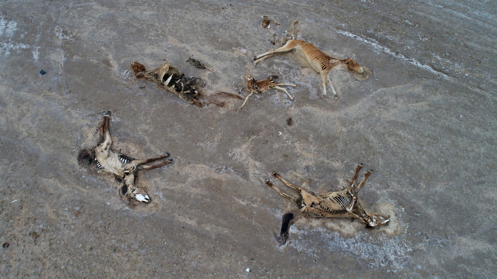
California’s drought. The state’s 39 million people are growing accustomed to the reality that there is not enough water for everyone — agriculture, industry, homeowners, fish and wildlife. Small water systems are in crisis. With groundwater supplies collapsing, many wells in rural areas have run dry, requiring water to be trucked in. A paucity of rain has made wildfire a persistent menace up and down the state.

Political fights over access to water will surely intensify as drought continues and shortages are prolonged. But according to Jay Lund, a professor of civil and environmental engineering at the University of California at Davis, the direction of those contests is becoming clear. In addition to his work on flood control and environmental water usage, Lund is an expert at modeling and optimizing California’s water supply. I spoke to him via email this month and last. A lightly edited transcript follows.

Francis Wilkinson: When we spoke last summer, you were optimistic about California’s capacity to manage drought and still prosper. Since then, the drought has not gotten better — although there was some welcome snow in the Sierra Nevada in April. Are you more worried now or are you still confident that California has enough water for its economy and its people?

Jay Lund: Most of California’s economy and people will be fine, despite being affected by this drought. There will be substantial water shortages for some major urban areas, and bigger effects on forest and fish ecosystems, agriculture, many rural wells, and some small water systems. All told, it will probably be comparable to last year and to the 2014 and 2015 drought years. Those droughts produced several billion dollars of economic losses. But you have to keep in mind that those losses are sustained within a statewide economy that exceeds $3 trillion per year.

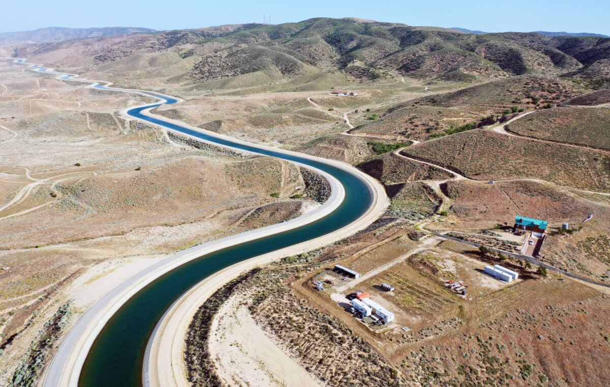
Q: Southern California depends on water from sources elsewhere — including the Colorado River and rivers in Northern California. Those rivers are failing to supply enough water for all the various entities that depend on them. What happens if those rivers don’t recover, and water supplies are further constrained?

A: About a third of Southern California households have been restricted to watering their lawn once per week, which should lead to a 20% to 30% reduction in water use for those households. But harsher conditions have so far been avoided because Southern California can draw on water from sources other than the Colorado River and Northern California. They can purchase water from other districts. For example, San Diego has not yet required mandatory water use reductions. In addition, Southern California has made great strides in water storage and permanent per-capita use reductions. Finally, waste-water re-use and ocean desalination have modestly increased water supplies.

Despite those successes, the Colorado and other rivers are perhaps in a prolonged “megadrought,” exacerbated by the higher temperatures of recent years. If these conditions continue or worsen, the water that Southern California has managed to store during wet years will be depleted, and water-use restrictions and purchases of water from farmers will necessarily increase.

Q: How much drought can the state take before it more aggressively prioritizes water usage, restricting water to less productive entities? And is the market or the state the ultimate decision maker, given so many competing interests?

A: The state has already restricted water allocations from major water projects to cities and farms. It has also curtailed surface-water diversions. Some of these reductions are pretty serious. California agriculture this year is likely to experience an overall reduction of 30% or more in surface water availability, which is similar to reductions last year and the drought years of 2014 and 2015. Some of those reductions will be eased by additional groundwater pumping and water purchases from farms that fallow fields previously devoted to lower-revenue crops.

Most of the “water market" consists of individual transactions negotiated among willing buyers and sellers, including farmers, irrigation districts and cities. The market is decentralized, but fairly effective at compensating farmers who transfer their water allotments to others who are struggling to keep orchards alive.

Q: Replacing surface water with groundwater pumping has produced some disastrous consequences, leading to dry wells and land subsidence so severe that infrastructure, including roads and bridges, have buckled. With aquifers depleted, isn’t more groundwater pumping just exacerbating the problem?

A: Additional agricultural pumping during droughts tends to deepen groundwater overdraft and leave rural wells dry. On the other hand, the additional pumping reduces agricultural and community economic losses from drought. The state has developed programs to identify households and rural communities with dry wells and supply them with bottled water, deeper wells or connections to neighboring water systems. Nevertheless, this remains a big problem in rural areas. Recent state legislation, which phases in regulations to end groundwater overdraft, should help stabilize groundwater levels and reduce the number of wells going dry during drought, but this will remain a problem. Ultimately, ending groundwater overdraft will require the long-term fallowing of a lot of agricultural land.

Q: In addition to reduced water availability, high temperatures are also increasing agricultural demand for water. The Public Policy Institute of California, a think tank that you’re affiliated with, estimates that warmer temperatures in 2021 — almost 3.5 degrees Fahrenheit above the 20th-century average — led to an 8% increase in crop water demand last year. So even if conservation efforts somewhat mitigate water loss, you have increased heat causing a spike in demand. Doesn’t something pretty significant have to give here?

A: Yes. Climate change has billions of dollars of implications for California’s economy. Some localities and regions will feel the impacts more acutely, especially agricultural areas, which are already fallowing hundreds of thousands of acres to end groundwater overdraft. In addition, the ecological effects of climate change are fundamentally reshaping the ecology of California’s forests and are making aquatic ecosystems even harder to manage.

Q: So, due to water scarcity, some rural areas will have to make the transition to a nonagricultural future?

A: An economic base that involves less irrigated agriculture would be more sustainable and more resilient to drought. For example, we can continue to shift land use from lower-valued crops to solar-power generation. But only a small portion of fallowed agricultural land will make that transition. Most of that land will simply become dry-land habitat, perhaps with low-intensity grazing. Rural communities in these areas will shrink unless they develop economic activities that are less reliant on water.

Q: One frequent suggestion along those lines is to phase out water-intensive crops such as almonds and replace them with less thirsty crops. But you have championed a different approach — prioritizing high-value crops over lower-value crops. Can you explain that?

A: What is happening is investment in crops with high profits per drop of water use, and the fallowing of crops with low revenue per drop of water use. Even though almonds use a bit more water per acre than, say, corn, they typically provide much more revenue per drop of water. Prioritizing crops based on minimal water use rather than on profitability would likely increase rural poverty.

Q: Given how much water is devoted to urban and suburban landscaping, wouldn’t it make more sense to restrict water for landscaping before imposing further restrictions on agriculture?

A: Maybe. But urban California uses only one-fifth as much water as the state’s agriculture does. So agriculture will have to use less water no matter what happens in the cities and suburbs. A rising price for agricultural water seems the best way to accomplish the necessary reduction in water use. Even if urban areas managed to meet all their water needs through recycling, desalination and conservation, our ecosystems and agriculture would still be in drought, because these are much bigger water users.

Q: Presuming drought is persistent, how does California look a decade from now? How will agriculture be different? How will consumers be affected?

A: Irrigated agriculture will occupy a noticeably smaller area of California. The remaining crops, on average, will produce higher revenues per drop. Cities will use less water, by engineering more water re-use, better water banking, and higher reliability and conservation.

But there is no escape from drought in California. Cities must be prepared for substantial water rationing in extreme cases. Forests will have fewer trees per acre, and different tree species in many areas. Aquatic ecosystems, sadly, are likely to have greater populations of non-native species.

California will always suffer from water problems, but most of the state’s economy can remain prosperous and healthy with proper management. Cities have considerable room to reduce per-capita water use. Agriculture, while shrinking in area and water use, seems likely to continue to grow economically with higher yields and more profitable crops.

California has continued to grow and prosper for 150 years despite its changing and challenging water problems. Managing ecosystems will remain the most difficult challenge for the state.

More From Bloomberg Opinion:

Trouble for Sin City (Las Vegas).

Sacrificing Lake Mead to Save Lake Powell
May 10 2022
The federal government recently announced it is taking unprecedented, emergency steps to help boost water levels at Lake Powell by holding back teh release of 500,000 acre feet of water. While this is good news for power production at Lake Powell, it means water levels at Lake Mead will continue to decline for the foreseeable future. In this video we review the water levels at Hoover Dam's reservoir, Lake Mead. Then we discuss the plan to hold water in Lake Powell, effectively sacrificing Lake Mead. We also discuss how the water level at Lake Mead has dropped so low that Water Intake #1 is now above the water line. How will this low water impact operations at Hoover Dam? Will Hoover Dam still be able to generate hydroelectric power? #LakeMead #HooverDam #Drought22 #ColoradoRiver #Arizona
 

From #forteschaleurs are expected over the next few days to the south of #pyrenees to the north we should pass the 30 degree mark but it is above all at altitude that the heat will be remarkable with a 0 above 4000m and 22 to 24 degrees 1500m 🤔

Good morning! Current temperatures at #Andorra 6.8ºC in Les Salines
@Ordinoesviu 11.3ºC at Roc St.Pere @SantErmengol@AndorraCapital @comuee10.6ºC at Borda Vidal @comusantjulia

Such extreme swings within the evening and am hours of temperatures.


09.06.2022 | Roman Oester | News SLF

The snow ablation date at the SLF test site on the Weissfluhjoch was 6 June 2022. This is the second earliest date since manual measurements began in winter 1936/37. A striking feature of the statistics is that the earliest snow ablation dates have occurred predominantly in the last 30 years. Another record was broken outright in winter 2021/22.

Eighty-six years ago, the "Expert Commission for Snow and Avalanche Research in Switzerland" began to carry out continuous, manual snow measurements on the Weissfluhjoch above Davos. For the SLF, that work is over for the time being, as Monday, 6 June 2022 marked the official date of snow ablation (Ausaperung in German). This means that more than half of the measuring site is free from snow. The statistics show that winter snow cover measurements are coming to an end increasingly early, with seven out of the ten earliest ablation dates being within the past 30 years. Moreover, this year's early-June date is almost a record-breaker, falling just three days later than the earliest such date in 1947.

1654843053557.png
Webcam shots of the Weissfluhjoch test site between 29 May and 6 June 2022, taken at 8 o'clock. Photo: SLF

More interesting facts about early snow ablation

  • As in 1947, the SLF reported several major Saharan dust events in winter 2021/22, which contributed to the rapid melting.
  • The snow had been melting continuously since 1 May 2022, when it measured 161 cm, 20 cm more than on the same day in the record year of 1947.
  • The snow depth last winter peaked on 16 February 2022 at 205 cm, which was about an average depth.
  • However, the total amount of new fallen snow was 663 cm, well below the average of just under 10 m.
  • The snow ablation date on the Weissfluhjoch has advanced by 1.2 days per decade since measurements began: the current average is 28 June, compared with 11 July in the middle of the 20th century.
  • Last winter saw the shortest duration of snow cover since records began, with snow lying on the Weissfluhjoch test site for 'only' 216 days. By comparison, snow cover in winter 1973/74 lasted over three months longer (315 days). This short duration is also not an isolated case, but part of a more general trend over the past 30 years.

    1654843262673.png
1654843329145.png
Chart showing manual snow measurements at the Weissfluhjoch test site for the hydrological year 2021/22. Graph: SLF
1654843443862.png
 

Attachments

  • 1654843009534.png
    1654843009534.png
    184.7 KB · Views: 1
(Machine translation)

Great heat: Over 30 students collapse at a sports festival

Jun 23, 2022 at 7:34 p.m

Velbert (dpa) - At a sports festival at a school in Velbert in the Mettmann district, over 30 students collapsed in the midday heat on Thursday. According to the fire department, twelve of them had to be treated by the rescue service and some were taken to nearby hospitals. The other students were picked up by their parents.

I find this really strange. Children are usually more resistant, so to see 30 pupils collapse - is it due only to heat or something more is added to the mix....?

Here in NRW, the weather is heavy. We had a heat wave 1-2 days with 36-37 temperatures. And then came the rain and cooled off the air.
Then again we had yesterday 31 degrees; it was very heavy to breathe, like a different kind of warmth. And in the night again came the storm. It is warmth mixed with moisture.

There was also hail in some parts of Germany. I reported about it here.
 
(Machine translation)


I find this really strange. Children are usually more resistant, so to see 30 pupils collapse - is it due only to heat or something more is added to the mix....?

Here in NRW, the weather is heavy. We had a heat wave 1-2 days with 36-37 temperatures. And then came the rain and cooled off the air.
Then again we had yesterday 31 degrees; it was very heavy to breathe, like a different kind of warmth. And in the night again came the storm. It is warmth mixed with moisture.

There was also hail in some parts of Germany. I reported about it here.
do you know the age of the children?
 
This morning the current heat wave along this border was at 14.5 C*. It seems this may be the return of the year without a summer perhaps.

Satellite images #meteo provided by the model #ARPEGE meteolab until Tuesday 7H https://meteolab.fr/modele/sat.html

Today, is another complicated day for agriculture with violent hailstorms from Toulouse to Colmar. Yesterday, the Médoc and Cognac vineyards were particularly hard hit. Map @KeraunosObsPhotos: Christian Daniau and Nicolas Suanez.


Jun 20, 2022
Lake Mead. Lake Mead Water Level. Lake Mead Water Level 2022. Hoover Dam. Lake Mead Update. Lake Mead Drought Update. What's Going On? Lake Powell Water Level 2022.why is lake mead drying up, lake mead drying up, lake mead discoveries, lake mead water level time lapse, lake mead drought, lake mead time lapse, Colorado river drying up, lake mead before and after, lake mead update, mead lake, Lake Powell, lake mead is drying up, lake meade, lake powell 2022

Drought is unearthing stunning discoveries from Italy's longest river

The dry spell is being called the country's worst in 70 years, and it has driven water levels so low in the famous Po River that a relic last seen in 1943 was revealed
Published Jun. 23, 2022, 5:46 PM CEST Snip:
One of Northern Italy's worst droughts in recent memory has dried up the country's Po River, unearthing relics that are typically covered up by the river's flowing currents.

The Po River, Italy's largest river at 405 miles long, is also the biggest reservoir of fresh water available in the country. The persistent drought, which is being called the worst in 70 years, threatens to challenge Northern Italy's supply of drinking water and make life difficult for farmers in the region.

In the northern village of Gualtieri, situated roughly between Florence and Milan, the river is so dry that a World War II-era barge has emerged from the river. The ship, known as the Zibello, is a 50-foot-long barge that sank in 1943. Normally, it is fully covered by the Po's waters. Now, much of the rusted ship has risen from the waters and is available for locals and tourists alike to gawk at.

1656055534340.png
“It’s the first time that we can see this barge,” amateur cyclist Raffaele Vezzal told The Associated Press as he hopped off his bike to get a glimpse of the unusual sight. Temperatures in Gualtieri have been in the low to mid-90s there the last 10 days or so, which is well above the normal of 82 for this time of year.

Elsewhere along the river, other smaller items are emerging from the depths for the first time. With large sections of the river's sandy floor now walkable, rocks, logs and large bones can be seen littering the ground.
 
No, I´m still exploring this for Stories of Covid vaccination side effects or worse thread because I suspect there is a link to vaccination.
same suspicion. but you know, young children have thermoregulation problems. it happened to me with my son years ago in sardinia during a historic heat wave, and despite all precautions. If the children are older than 5 or 6, then it would be interesting to relate the event to the age vaccination rate in the country of reference. but not only that. there is a trend that seems to me to be evident and related in general, to the anti-epidemic policies adopted in recent years. they make you unfit for change, even if only in heat and humidity.
 
Locally and for the country of France will go ballistic with a new heat dome in the coming days. Obviously, fires will be a considerable concern.

At 500 HPA, progressive installation of the heat dome in the next few days with the feeding action also of the cold drop. There is a risk of reaching 600 DAM on the Iberian Peninsula and possibly in France. An unprecedented event climatologically speaking!

Line-1
New heat wave episode next week with a #chaleur which will rise crescendo over the days. The #pyrenees and the #sudouest will unfortunately be in the front row with this burning air mass coming up from the south: 28/30°c at 850hpa is equivalent to 30/32°c at 1500m. Infoclimate
Line-2
In the plain, 40°c can be approached locally in Gascony from Tuesday, 34 to 38°c elsewhere.

1657457918429.png


Cold and cooler anomalies


Heat exhaustion vs. heatstroke: What are the warning signs and how should you react?
By Jillian MacMath, AccuWeather staff writer
 

Attachments

  • 1657457553858.png
    1657457553858.png
    640.3 KB · Views: 3
  • Screenshot 2022-07-06 at 21-48-27 Tahoe Daily Tribune.png
    Screenshot 2022-07-06 at 21-48-27 Tahoe Daily Tribune.png
    1.7 MB · Views: 3
Back
Top Bottom