The Ice Age Cometh! Forget Global Warming!

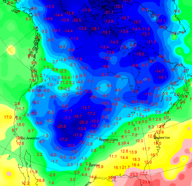
The invasion of the Canadian cold has turned the head of the American winter. Without waiting for November, she bound a huge territory in the middle of the United States with ice and frost. For example, in Denver, the temperature dropped to -15. Although a week ago in the capital of Colorado it was +25.
It's hard to believe, but at the end of October, the states with subtropical climates were hit by 20-degree frosts! In the town of Pueblo, Colorado, the thermometer showed −22.2. Frosts similar in strength were noted in Nebraska, Wyoming, Idaho and Utah. The small town of Craig in Moffat County, Colorado, where the temperature was -25.6 in the early morning of October 28, became the "pole of cold" of the United States these autumn days.
Tn-3-640x619.jpg


In addition, yesterday there was news that

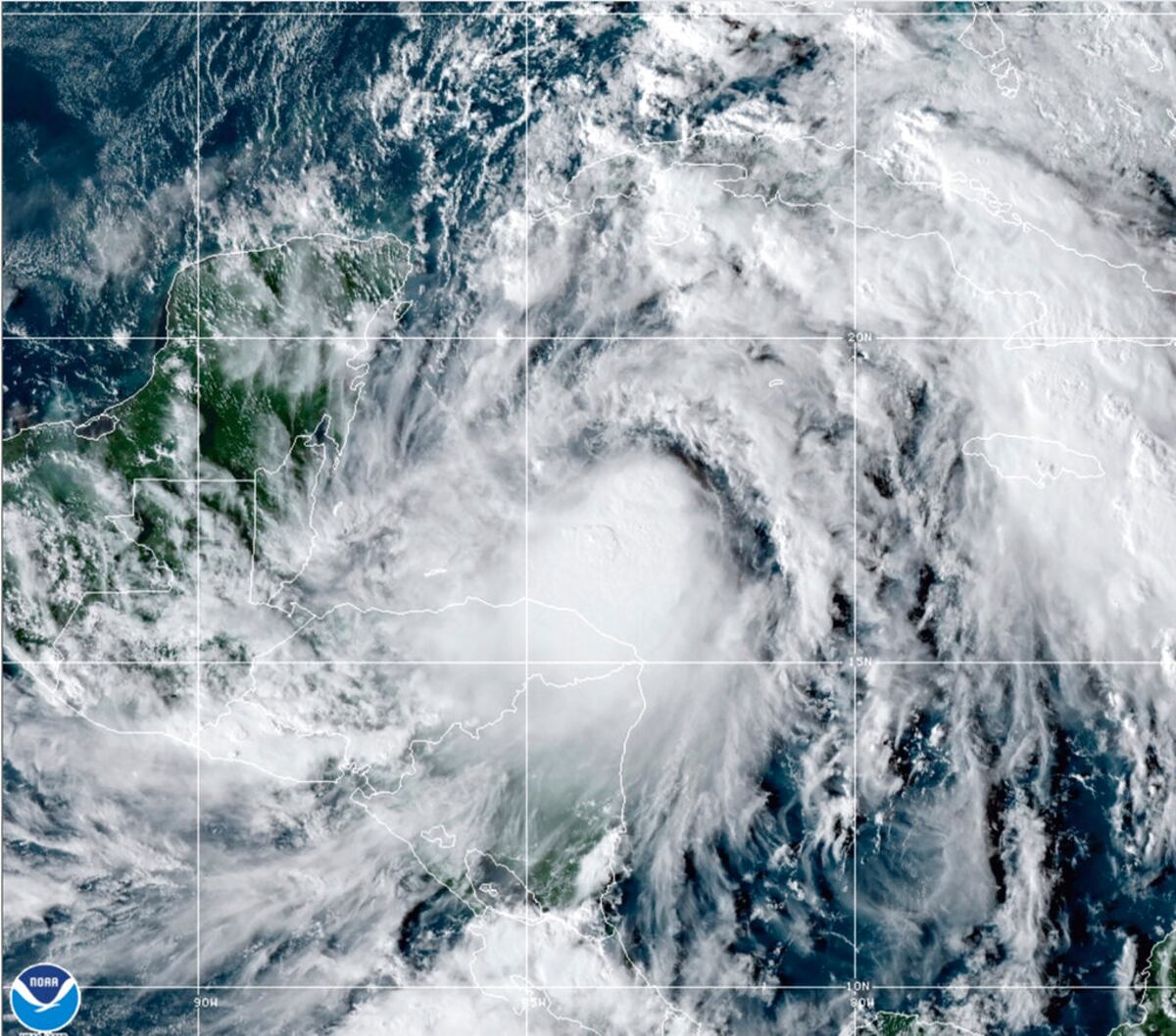
Hurricane Zeta hits Yucatan and moves towards Louisiana
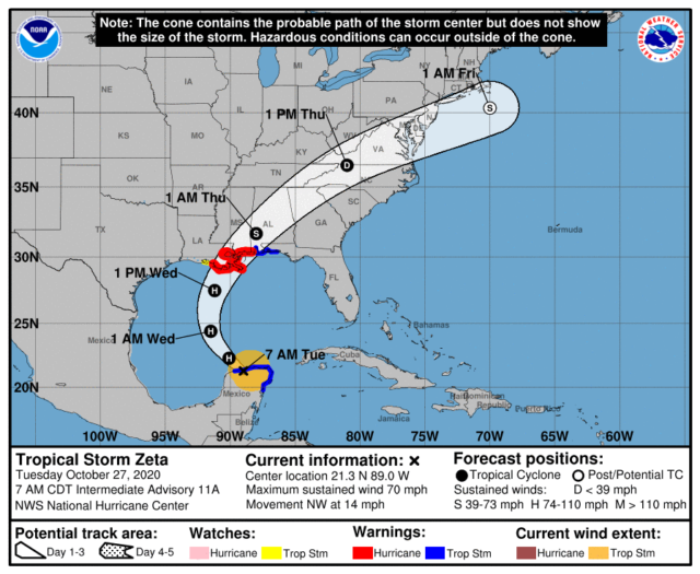
Hurricane Zeta entered the territory of the Yucatan Peninsula, known all over the world for its resorts. The weather system is located northwest of the city of Tulum and moves northwestward at a speed of about 22 km / h. The wind speed reaches 112 km / h.

In the north and north-east of the peninsula, there are showers, strong gusts of wind blowing away roofs and trees, a storm warning has been announced. Waves in coastal areas reach 7 meters in height. Already today, Zeta will enter the Gulf of Mexico, moving towards the south of the United States. Tomorrow the weather system will enter the United States near the border of Louisiana and Mississippi.

Louisiana Governor John Bel Edward has declared an emergency in the state. He urged residents to prepare for the disaster, paying particular attention to the correct handling of generators. The disaster is expected to have the greatest impact on Louisiana on October 28 and 29.
091825_5day_cone_no_line_and_wind-640x525.png


PS We see that almost SIMULTANEOUSLY two forces hit the US territory, a cold from the north and a hurricane coming from the south. This is a bit like The Day After Tomorrow. I wonder what will happen on the planet this winter?
 
Hurricane Zeta hits Yucatan and moves towards Louisiana

Snip: 7-9 minute Read:
NEW ORLEANS (AP) — Hurricane Zeta slammed into the storm-weary Gulf Coast on Wednesday, pelting the New Orleans metro area with rain and howling winds that ripped apart buildings, knocked out power to thousands and threatened to push up to 9 feet of sea water inland in a region already pounded by multiple storms this year.

The storm killed at least one person, a 55-year-old man who a Louisiana coroner said was electrocuted by a downed power line in New Orleans, and officials said life-threatening conditions would last into Thursday.

St. Bernard Parish President Guy McInnis said emergency workers were doing their best to respond to reports of people in distress after their roofs were blown off.

“Guys, we received the brunt of Zeta, and Zeta gave us a good punch,” McInnis told WDSU-TV.

Roads were flooded near the coast, where forecasters said Zeta made landfall around Terrebone Bay near Cocodrie, an unincorporated fishing village at the end of a highway with few if any full-time residents and a marine laboratory where a building was inundated.

Streams of rainfall ran off roofs in New Orleans' famed French Quarter, signs outside bars and restaurants swayed back and forth in the wind and palm trees along Canal Street whipped furiously. Officials said a person was hospitalized with minor injuries after a structure collapsed, but further details weren’t available.

With much of the city in the dark and more than 200 trees reported down, New Orleans Mayor LaToya Cantrell implored residents to stay home and let city officials assess the damage instead of going out and doing it themselves.

More than 875,000 customers were without electricity in Louisiana, Mississippi and Alabama, including about 350,000 in metro New Orleans. Outages were mounting quickly as the storm moved northeastward across the Deep South.

#Huracán#Zeta weakened to category 1 on the scale #Saffir -Simpson. It remains on land 70 km northeast of Hattiesburg, Mississipi, United States of America. Details in the link https://smn.conagua.gob.mx/es/pronosticos
 
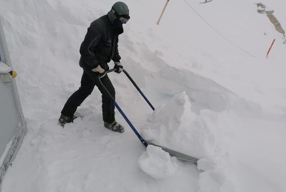
I've took this photo two days ago while flying from Frankfurt to Zagreb, over the Austrian Alps. Seems quite extensive snow cover for this time of year.
Wow indeed a magnificent sight and you are right, it is quite extensive for this time of the year as official snowfall stats aren’t usually reported this early into the season, but numbers of up to 20cm (8 inches) were widely registered across the Austrian and Italian peaks, with some areas saying they had received 80+cm (nearing 3 feet) by Tuesday morning. In total, around 25 ski areas are already open in the Alps and Scandinavia, and the first ski areas have also opened in U.S. and Canada where recent vast accumulations of record-smashing snow has helped drive the Northern Hemisphere Total Snow Mass to a staggering 300 gigatons above the 1982-2012 average.

The COLD TIMES are returning, the mid-latitudes are REFREEZING in line with historically low solar activity, cloud-nucleating Cosmic Rays, and a meridional jet stream flow.


Both NOAA and NASA appear to agree, if you read between the lines, with NOAA saying we’re entering a ‘full-blown’ Grand Solar Minimum in the late-2020s, and NASA seeing this upcoming solar cycle (25) as “the weakest of the past 200 years”, with the agency correlating previous solar shutdowns to prolonged periods of global cooling here.


Furthermore, we can’t ignore the slew of new scientific papers stating the immense impact The Beaufort Gyre could have on the Gulf Stream, and therefore the climate overall.
 

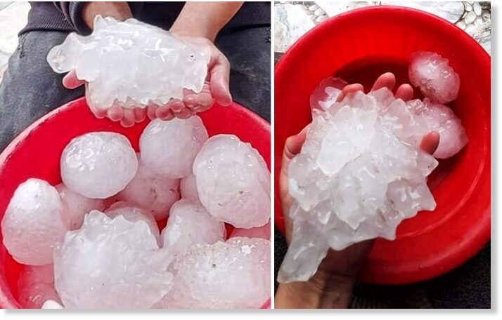
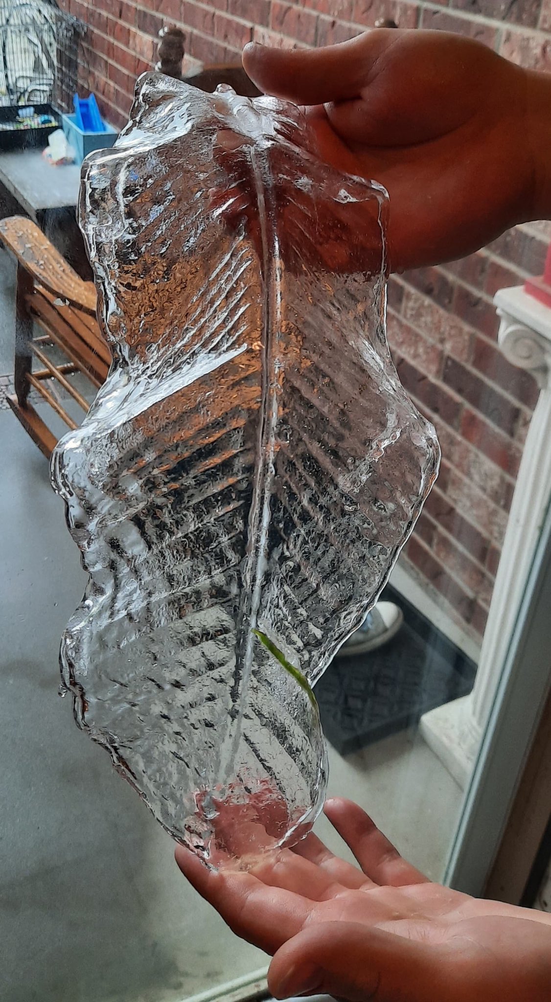
The capital of Libya, Tripoli has been hit by an unprecedented severe supercell storm on Tuesday, Oct 27th, 2020. The storm produced exceptionally large, *giant* hail, possibly more than 8 inches (20 cm) in diameter. The first reports indicate that hailstones could be one of the largest ever recorded on Earth!

Such hail size would definitely fit into the world's Top 3 giant hailstone events reported globally. Besides the Vivian (south Dakota) hailstorm from 2010 and the so-called 'gargantuan' hailstorm in Argentina in 2018.
 
The Beginnings of a Mini - Ice Age - COAST TO COAST AM - September 23, 2020
COAST TO COAST AM - September 23, 2020. Robert Felix, a former architect, became interested in the ice-age cycle back in 1991 and has been researching and writing about the possibility of a coming ice age ever since. In the first half, he argued that we are seeing the beginnings of a mini-ice age, which several astrophysicists have also recently concluded, he noted. This cycle may be similar to what happened in the 1600s when the sun had no sunspots.

 
Meanwhile in the fruit basket of my own province:


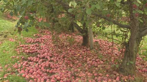
The ground of some orchards in East Kelowna is blanketed by soon-to-be-spoiled apples.

“I could cry,” apple grower Julius Kish said. “People are hungry, and it’s so much waste.”

In 50 years of farming, Kish said he’s never seen a worse growing season.

It started in the spring with hail and too much rain.


Apple growers then struggled to find fruit pickers because the COVID-19 pandemic brought about a shortage of temporary foreign workers to tend the crops, Kish said.“I only had three people the whole summer working for me. Can’t get any local people,” he said.
Kish is frustrated that his apples were left to rot because of a lack of fruit pickers, while many Canadians were sitting at home collecting $2,000 a month through the Canada Emergency Response Benefit (CERB), he says.

The labour shortage was then followed by a record-breaking snowfall and the earliest cold snap Kish can remember seeing in his half-century of growing.
 

80% of Russia is Buried in Snow​

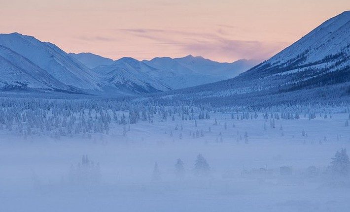
On October 30, “very cold weather was established” in north Siberia, reports hmn.ru. Unusually chilly lows of -20C (-4F) were suffered in Salekhard which resulted in hard frosts. Even during the day, highs in the region only climbed to -12C (10.4F) — readings that are some 16C below the seasonal average.

In addition to the cold, approximately 80% of the transcontinental nation is buried under early season snow — a feat rarely achieved this early in the season (Oct 29) since records began in 1998, and one particularly impressive given the far-west’s lingering warm setup (a phenomenon driven by the positioning of the jet stream, not a trace gas in the atmosphere).

Looking at data from Rutger’s Global Snow Lab (shown below), the pack also descends as far south as China, and as far west as Scandinavia. This impressive cover has contributed to the Northern Hemisphere, as a whole, experiencing a record-breaking snowy start to the season.

1604226387496.png


The COLD TIMES are returning, the mid-latitudes are REFREEZING in line with historically low solar activity, cloud-nucleating Cosmic Rays, and a meridional jet stream flow.
 
Arctic Sea Ice is not freezing In October for the first time since measurements began, now having an unknown effect on weather development towards Winter

Adapt 2030 discusses this here:

Ocean Current Disrupted Arctic Basin Not Freezing​


The Arctic Ocean has not refrozen in October the first time in "recorded history". The new incredible fast moving current that is blocking water circulation is coming from the Gakkel Ridge where the Earth's crust has split and water in the planet's crust is pouring out like a pressurized aquifer, disrupting the Murman and Spitzbergen Currents in the Laptev and Kara Seas.


Another sign of Earth 'opening up'?
 
Meanwhile in the fruit basket of my own province:
Over a few valleys from this fruit basket, and just over the midway point of October, temps here plummeted to -10 c and -15 c over a number of days, and overnight, and warmed during the day; somewhat. The snow also came to the valley while green leaves were in the transition of a normal fall and froze green. The cold (and snow) then moved West hitting the fruit basket you mention last week. It was January in October.

The mountains here are now pregnant with snow - a good month earlier than usual. Can even recall certain December times when the bears were desperately want for snow in the mountains to bury and hibernate in.

The Beginnings of a Mini - Ice Age - COAST TO COAST AM - September 23, 2020
Good talk, c.a.!

Robert Felix: glaciers rising, sea water lowering...
 
After catching up on last few pages of this thread, I thought it important to share a site I found a little while ago. The site is plateclimatology.com by James E Kamis.
From his About page:
James Edward Kamis is a Geologist and AAPG member of 41 years and who has always been fascinated by the connection between Geology and Climate. Years of research and observation have convinced him that the Earth’s Heat Flow Engine, which drives the outer crustal plates, is also an important driver of the Earth’s climate.
He received a BS in Geology from Northern Illinois University in 1973 and an MS in Geology from Idaho State University in 1976. He is proud to have worked for mining and oil companies that practiced responsible harvesting of materials necessary to sustain human life; Becker Industries, ARCO, Cross Timbers, Texaco, Fina, Union 76, and BTA Oil Producers LLC. He is currently retired.
James has developed the Plate Climatology Theory entirely on his own non-working hour time and with no funding from BTA Oil Producers LLC or any other entity.
He is also proud to state that he is an actively practicing Christian who believes science and spirituality are completely compatible. However, he developed the Plate Climatology Theory entirely based on scientific observations, geological intuition and inclusion of many published scientific research articles, many geological in nature.
The Plate Climatology Theory is built on the premise that there is a strong connection between geology and climate. The theory is intended to promote interaction between many branches of science primarily; geology, climatology, meteorology, biology, and oceanography. As such, it is not intended to debunk the Global Warming Theory, rather it is intended to offer a alternative theory that explains observed natural phenomenon.
The basic tenants of the Plate Climatology are sound; however it is a working theory which like all theories will likely need modification. This is invited, because that is how science should operate, formulate a good theory and then put it to many tests.
The development and intent of this theory is in no way politically motivated. It is not an attempt to demean any particular political group, university, government agency or group of scientists. James does in fact believe that climate scientists have been “atmospherically” biased in their interpretation of many observed climate trends and climate related. He believes that the vast majority of these scientists are highly skilled and dedicated individuals. James does not subscribe to utilizing his Plate Climatology Theory as a political or personal weapon to demean others. They have the right to disagree with this theory.

...how refreshing to find such an open-minded scientist! Kamis' theory doesn't challenge any of the working theories previously presented in this thread (he sounds sooooo humble, or maybe just cautious), but in my opinion, this information greatly enhances and fleshes out all current working climate change theories.
The Adapt2030 video approached the subject of Gakkel Ridge in the Artic Basin being possibly/partly responsible for anomalies on Nullschool maps. I thought he was going to expand on it and include Kamis' findings in the Arctic, but stopped short of the big reveal.
Davidson, of Suspicious Observers, has great science on spaceweather effects on climate and earthquake activity, but is missing this geological symptom which could also be contributing to climate change. If the solar activity can contribute to earthquake activity, why not to vulcanism on plate boundaries, as well? Also, Davidson credits the solar wind exclusively for the increasing ozone hole over Antarctica with nary a mention to the increased volcanic activity in western Antarctica. Activity that releases ozone depleting CFCs. (CFCs were one of the causes of global warming transmitted by the C's, but didnt' indicate whether CFCs were man made or "natural"; but Niall shares a great article in this post, suggesting the latter.)

Kamis' hour long video, The Plate Climatology Theory, fills in a LOT of gaps as he shares his expertise in geology and educates us on what's going on under the ice and waves?
He not only covers what he knows about the ocean floor up at the North pole, but also covers the Antarctic areas, The Galapogos Island area, as well as the Pacific Ring of fire and the origin of La Nina/El Nino occurrences.

I highly recommend his video to anyone interested in learning about this highly dismissed player(submarine volcanism) in climate change theories. I'm not promoting it as a complete theory, but rather a BIG piece of this huge puzzle which could help make other theories more comprehensive and converge with each other.


80% of Russia is Buried in Snow​

On October 30, “very cold weather was established” in north Siberia, reports hmn.ru. Unusually chilly lows of -20C (-4F) were suffered in Salekhard which resulted in hard frosts. Even during the day, highs in the region only climbed to -12C (10.4F) — readings that are some 16C below the seasonal average.

In addition to the cold, approximately 80% of the transcontinental nation is buried under early season snow — a feat rarely achieved this early in the season (Oct 29) since records began in 1998, and one particularly impressive given the far-west’s lingering warm setup (a phenomenon driven by the positioning of the jet stream, not a trace gas in the atmosphere).

Looking at data from Rutger’s Global Snow Lab (shown below), the pack also descends as far south as China, and as far west as Scandinavia. This impressive cover has contributed to the Northern Hemisphere, as a whole, experiencing a record-breaking snowy start to the season.

In fairness, it must be said that there is still no snow either in Moscow or in St. Petersburg (as of November 3, 2020).

So in St. Petersburg, last October became the warmest over the past 100 years (+ 9.1C average temperature) and one of the warmest in history (+ 9.3C was in 1775).

In Moscow, October 2020 became the warmest in the history of observations (+ 9.2C average temperature, norm + 5C)

November is also promised warmer than normal, but the weather has become so unpredictable that it is impossible to say what will happen in 10 minutes outside the window (sun, rain, wind).

-------------------------------------------------- -----------------------

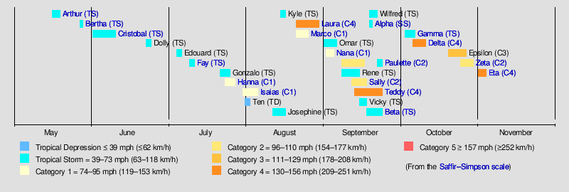
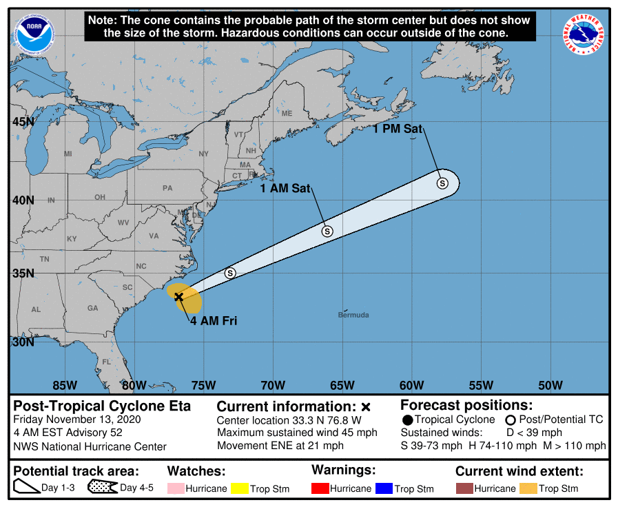
In addition, it is necessary to note the next tropical storm in the Atlantic. The 28th tropical storm for 2020 was named Eta.

bbd6c42417213bb1ff933accce6e1b43.png


On Monday November 2, Eta developed into a Category 4 hurricane in the western Caribbean. Eta is expected to have a disastrous impact on Central American countries due to its initial strength and very slow displacement.
NHC_AL292020_5day_cone_no_line_and_wind.png


Eta has a rare intensity for the end of the season. Only three Category 4 hurricanes (Lenny in 1999, Michelle in 2001 and Paloma in 2008) and one Category 5 hurricane (Cuban Hurricane 1932) occurred in the Atlantic during November ...

Combined, Eta can have the same catastrophic impact as Hurricane Mitch in 1998. "Mitch" wandered around Central America for several days. More than 10 thousand people died due to the catastrophic flood.

In terms of the number of tropical storms, the 2020 season caught up with the record 2005 season. Eta was the 28th tropical storm and 12th hurricane of the 2020 Atlantic season.

In many regions of Central America up to 600-900 mm of precipitation is predicted (more than in Moscow for a year!). Up to 1200-1500 mm is expected in the mountains. This amount of precipitation can lead to catastrophic flash floods and devastating landslides.
 
From Electroverse:

Record smashing snow and ice storms cause 'havoc' in Alaska and the Yukon


Record volumes of snow and ice began building Sunday afternoon across Alaska and NW Canada, and continued accumulating through Monday. The unprecedented storms soon strangled roads, knocked the power out for tens of thousands, and forced the closure of schools and businesses.

A boundary of cold Arctic air moved farther south than forecasters had originally expected, dramatically dropping temperatures across Alaska and the Yukon.

...Snowfall records were set across the state of Alaska, including in Juneau.

"On Nov. 1, Juneau Airport broke a record when it got 7.6 inches of snow," said NWS meteorologist Kimberly Vaughan, a reading that busted the old mark of 6.6 inches.

...In Fairbanks, located a short 17 hours drive to the NW, the 22 below zero observed at the city's International Airport marks November 2's third coldest temperature in recorded history. Only 1907's 33 below and the 24 below logged in both 1992 and 1975 beat yesterday's reading.

Meanwhile, the NWS reported lows of 25 below in North Pole and Manley Hot Springs, 27 below for Eagle and the Goldstream Valley, 24 below in Wiseman, 30 below in Circle and a whopping 40 degrees below zero in Chicken.

...Doug Lundquist, a meteorologist with Environment Canada, has worked in B.C. and Yukon for over three decades, but says he's "never quite seen a storm like this."

On Monday alone, accumulating snow in Whitehorse topped 47 cm (1.54 ft) — an amount that far exceeds daily records for November, which Lundquist said range from 5 to 15 cm (2 to 6 inches). In fact, it turns out that Monday's snow was Whitehorse's highest daily snowfall for any day in any month!


Trending content

Back
Top Bottom