The Ice Age Cometh! Forget Global Warming!

Entire Season Of Snow Could Dump On Texas Panhandle; Pipeline Operators Warned About 'Freak Storm'​


"The Texas Railroad Commission warned oil and gas operators across the Midland-Odessa and Panhandle regions about wintry precipitation through Friday."

"The combination of high winds and heavy wet snow through Thursday night into Friday will create whiteout conditions which will make travel extremely dangerous," local news ABC 7 said."


Mongolia warns of extreme cold in coming week​

mongolia-frio-1140x694.jpg
Large parts of Mongolia are expected to see extreme cold from the coming Monday and through the entire week, with expected overnight temperatures of 39 to 47 degrees Celsius below zero, the country's weather agency said Friday.

The weather agency said that heavy snow and snow storms are hitting the country's eastern and western parts, urging the public, especially nomadic herders and drivers, to take extra precautions against possible disasters.

Mongolia's climate is strongly continental, with long and frigid winters. A temperature of minus 25 degrees Celsius is standard during winter. Unstable weather events are also common in the country throughout the year.

 
Noteworthy records.


December could be much colder than the usual norm for North America and Canada.

Though the others say differently. So are we being set up?


Nutrien's Morning Minute - Nov 22, 2022
Nutrien Ag Solutions

1669148413345.png
1669152231028.png
1669152353191.png
1669384155331.png

Side-note:
 

Attachments

  • Screenshot 2022-11-25 at 08-35-46 Wouter van Bernebeek on Twitter.png
    Screenshot 2022-11-25 at 08-35-46 Wouter van Bernebeek on Twitter.png
    773.6 KB · Views: 4
At the time of posting it is night over Asia, but still moving back and forth a few hours does not change much, and it is cold:
View attachment 67406

I saw somewhere that the strip of cold should land on Europe on December 6. For the moment Meteo France predict min 2°C and max 8°C for Paris which is far from apocalyptic. Let see how it evolve and if they are right.

Paris weather.jpg
 

Attachments

  • Paris weather.jpg
    Paris weather.jpg
    8.3 KB · Views: 0

NEW STUDY: CLIMATE MODELS GOT IT WRONG, EASTERN PACIFIC OCEAN IS COOLING, LA NIÑA WINTERS COULD KEEP ON COMING

NOVEMBER 23, 2022 CAP ALLON

Earth’s climate system is unfathomably complex. Only a small percentage of the variables have been factored into the UN-funded models. A machine is only as good as the person that built it.

A new research paper has found ‘real world’ temperature differences in the Eastern Pacific Ocean that vary wildly from what the climate models say should be happening.
The study also suggests that La Niñas –the colder counterpart of El Niños– could keep on coming, adding to the climatic woes that the phenomenon delivers, which is to say harsher winters for much of the Northern Hemisphere, and heavy precipitation for the likes of Australia.

The global warming hypothesis favors El Niños, it always has.

The models decreed that El Niño’s would be the dominate ENSO pattern moving forward, correlating with rising global temperatures; the cold, deep ocean waters off South America were expected to rise to the surface, meet milder air and heat faster than the warmer ocean off Asia; this, in turn, would then decrease the temperature difference across the tropical Pacific and lighten the surface winds blowing toward Indonesia — aka, a El Niño setup.

Historical climate records confirm that during prior warm spells, Earth’s climate was more El Niño-like.

In recent years, however, La Niñas have been the dominant setup. In fact, the Northern Hemisphere is about to endure its third consecutive La Niña winter, something that has only occurred four times since 1900, and only twice since 1950.
So what’s going on? Is Earth now cooling?

The recent study, ‘Systematic Climate Model Biases in the Large-Scale Patterns of Recent Sea-Surface Temperature and Sea-Level Pressure Change’, looked at temperatures at the surface of the ocean recorded by ships and buoys from 1979 to 2020.

It was discovered that the Pacific Ocean off South America had actually cooled over that time, along with ocean regions farther south, too. This cannot be explained by the climate models. To put it delicately, big pieces of the puzzle are missing.

Like the sun, maybe?


The upshot of this ‘unexpected’ reality is that the temperature difference between the eastern and western Pacific has grown, instead of shrunk as was prophesied; the surface winds blowing toward Indonesia have strengthened, not weakened; and residents of the NH are enduring their third consecutive La Niña winter, instead of its warmer counterpart, El Niño.

The climate models –that our ‘betters’ base their world-reshaping policy decisions on– have gotten it entirely backwards.

The researchers openly admit that they don’t know why this pattern is happening. Lead author Robert Wills, a UW research scientist in atmospheric sciences, said his team are now exploring possible links to the Antarctic ocean, which is also cooling.

“There’s something about the regional variation, the spatial pattern of warming in the tropical oceans, that is off,” said Wills, of the models. “If it turns out to be natural long-term cycles, maybe we can expect it to switch in the next five to ten years, but if it is a long-term trend due to some processes that are not well represented in the climate models, then it would be longer. Some mechanisms have a switch that would happen over the next few decades, but others could be a century or longer,” he added.

Let that sink in…

Also note that the study only ran to 2020, so didn’t have the data for the two most-recent La Nina winters where a further intensification of the cooling has been noted.

Honest climate scientists admit that there are serious issues with the models, the biggest being ‘clouds’ — they simply haven’t properly accounted for them/don’t understand them.

“All models are wrong, but some models are useful,” so the quote goes. Well, thus far, climate models are seemingly only useful for pushing warped, antihuman, globalist agendas — they have provenly failed in every other regard.
 

Global Warming? Northern Hemisphere Snow Cover At 56-Year High

BY TYLER DURDEN

SATURDAY, DEC 03, 2022 - 01:00 PM

NOAA and Rutgers University released new data that showed snow cover across the Northern Hemisphere reached the highest level since measurements began in 1967 and are currently above the 56-year mean.


Caltrans remote video traffic camera, traffic moves slowly through the snowy
© Caltrans
In this image taken from video from a Caltrans remote video traffic camera, traffic moves slowly through the snowy conditions along Interstate 80 near Truckee, California, Thursday, Dec. 1, 2022.

It was a snowy start to meteorological winter across the mountains of California Thursday as a winter storm tracked across the state, and AccuWeather forecasters say that more snow is on the way.

The storm arrived in Northern California late Wednesday and continued throughout Thursday, delivering much-needed rain to the lower elevations. San Francisco International Airport measured 0.71 of an inch of rain on Thursday, nearly half of the 1.58 inches of rain that fell in all of November.

A yardstick was needed to measure the snow in the higher elevations with snow causing travel-related headaches for drivers across the region.

Interstate 80 at Donner Pass and Highway 50 at Echo Summit were closed periodically throughout the storm due to vehicles stuck on the snowpacked roads, but the roads have since been reopened to traffic.


The early-season snowfall was a boon for ski resorts across the region, including Mammoth Mountain, located 100 miles southeast of Lake Tahoe.

mmmmmm
More than 2 feet of snow fell over the resort in just 24 hours, leading to excellent conditions on the mountain.


"We have a beautiful powder day upon us with a storm total of 23-30 [inches], conditions are going to be incredibly fun," Mammoth Mountain said on its website Friday.

The highest snow report came from Sierra at Tahoe where 43 inches accumulated.

The snow was accompanied by strong winds, including a 123-mph gust at Washeshu Peak, California.
The hurricane-force wind gusts were not limited to California, as gusts over 80 mph were clocked in Utah and Colorado.

winds
"Feet of new snow and strong winds will overload an already weak snowpack and result in very dangerous avalanche conditions in the mountains," the Sierra Avalanche Center warned, according to a report from The Associated Press.

Skiers and snowboarders heading to the slopes may encounter disruptions due to avalanche mitigation efforts.

Another dose of rain and mountain snow is headed toward California this weekend, with snowfall accumulations of a foot or more once again expected in the higher elevations.

The new storm will also bring more meaningful rain to the lower elevations, including portions of Southern California.


China Peak Mountain Resort sees at least 2 feet of snow, expecting more

China Peak Mountain Resort
© China Peak Mountain Resort website.
There is good news for those who like to hit the slopes.

Officials at China Peak Mountain Resort said they saw some pretty consistent snowfall since around 3:30 p.m. on Thursday, December 1st. As of Friday, December 2nd, they have gained nearly two feet of snow since Thursday morning and they are expecting much more through the weekend.

Resort operator Tim Cohee says that China Peak will be open Saturday, December 3rd and Sunday, December 4th. In total, he says he's expecting anywhere from six to eight feet of snow by Sunday night.
 
Last edited:

Mammoth Mountain in California just got some major snow - almost 5 FEET in 5 days

Those are windshield wipers... we think. Mammoth Mountain received almost five feet of snow over the first five days of December 2022
© Peter Morning/Mammoth Mountain
Those are windshield wipers... we think. Mammoth Mountain received almost five feet of snow over the first five days of December 2022
We know the names of the seasons — spring, summer, fall, and winter — and we know the catchy nicknames for shorter stretches of the year, with "swimsuit season" and "jacaranda season" and "county fair season" and several other memorable monikers catching our fancy.

But up around Mammoth Mountain? The beginning of "things poking out of lots of snow season" has officially arrived with the major storm that swept through over the first weekend of December 2022.

If you know the Eastern Sierra ski destination, you know that when a lot of snowflakes fall, you're bound to see the tops of various items sticking out of snow drifts and snow banks, with windshield wipers, fence posts, and the famous mountaintop sign all revealing the impressive depth of the accumulation.


That accumulation was impressive indeed, with nearly five feet of fresh snow falling in December alone.

Video recently taken at the top of the mountain revealed high winds and blowing snow, a cold combination that added an icy intensity to an already dramatic winter event.

Here are some snapshots of the early December snowfall, a wintry wallop of a storm that promises primo holiday skiing.

The resort's distinctive vistas tell the frosty tale.
© Peter Morning/Mammoth Mountain
The resort's distinctive vistas tell the frosty tale.

Cozy cabin times at Tamarack Lodge and Resort.
© Peter Morning/Mammoth Mountain
Cozy cabin times at Tamarack Lodge and Resort.

Shoveling out: Snow was still falling on Monday, Dec. 5 with more in the forecast for December's second weekend.
© Mitchell Quiring/Mammoth Lakes Tourism
Shoveling out: Snow was still falling on Monday, Dec. 5 with more in the forecast for December's second weekend.

Chains were very much the order of the weekend around the area. As for the action on the mountain?
© Mitchell Quiring/Mammoth Lakes Tourism
Chains were very much the order of the weekend around the area. As for the action on the mountain? The Mammoth team says that it "... will be fully open as soon as crews can safely open the terrain."

Always check road conditions before visiting

Always check road conditions before visiting Mammoth Mountain and keep an eye on the destination's social pages for the latest on slope openings and what to expect with the coming storm.
 
I saw somewhere that the strip of cold should land on Europe on December 6. For the moment Meteo France predict min 2°C and max 8°C for Paris which is far from apocalyptic. Let see how it evolve and if they are right.

View attachment 67408
Finally the temperatures forecasted for the week of December 6 by Meteo France were really a bit above reals temperatures. Here's a screenshot done on December 6.

températures 06-12.jpg

This day forecast show temperatures still around 0°C for coming days:

température 11-12-2022.jpg
 
Insane snowfall at Donner Pass California.

Train Plowing railroad tracks after a winter storm - December 2022 - Donner Pass
This is in Soda Springs, CA just on the west side of Donner Pass. I couldn't shoot in the pass due to visibility being below required for drone flight. #trains are Union Pacific. I'll openly admit I do not know a lot about trains but always wanted to get shots of them #plowing and took up #trainspotting for a day. Perhaps a #railway fan can help me out in the comments. Shots took place after 4 feet of snow fell in Soda Springs #California after a major #snow #storm. Licensing via www.wxchasing.com


Screenshot 2022-12-12 at 07-17-14 NWS Sacramento (@NWSSacramento) _ Twitter.png
 

Winter storm pummels western US with heavy snowfall - 5 FEET of snow in 48 hours at Soda Springs, California

The storm is expected to reach the Great Basin and the Desert Southwest by Monday, the Weather Service said.
© Caltrans
The storm is expected to reach the Great Basin and the Desert Southwest by Monday, the Weather Service said.

A large winter storm system slammed into the western US over the weekend, blanketing mountain areas with heavy snow before taking aim at the South, where it's expected to bring severe weather, with strong winds, hail and tornadoes possible.

More than 15 million people in 14 states are under some sort of a winter weather alert as the powerful storm moves across the county.

The storm already brought avalanche warnings to parts of the West, shuttered major highways as conditions became icy and triggered flood watches.

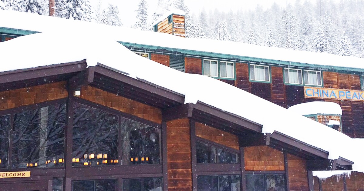
The storm blanketed some mountain areas of drought-parched California with thick snow, including Soda Springs in the northern part of the state, which received 60 inches of snow in 48 hours.

A multi-day severe storm threat begins Monday for parts of the South and southern central US. A slight threat for severe weather has been issued for parts of western and central Kansas and Oklahoma into northwestern Texas.

The threat does, however, strengthen as the system heads east Tuesday, likely impacting a large swath of the Lower Mississippi River Valley. Areas including Baton Rouge, New Orleans and Shreveport in Louisiana and Jackson, Mississippi, could see tornadoes, high wind gusts and damaging hail.

Additionally, the National Weather Service in Denver forecast whiteout and blizzard conditions for Tuesday in parts of the plains in Colorado.

To the east, residents in Fargo, North Dakota, are expected to see snowfall over 6 inches and will be under a winter storm watch from late Monday night until late Wednesday night. Duluth, Minnesota, could also see 6 inches of snow and will be under a winter storm watch starting Tuesday morning.

Though the storm is walloping some areas with severe weather, it's forecast to track across drought-stricken areas, bringing much needed relief - including to the Mississippi River Valley area, where excessive rainfall is possible Wednesday.


'It looks a lot like Christmas out here'

In the Sierra Nevada, snow pack totals are already above average, according to the National Weather Service in Reno.

Winter storm warnings were in place overnight for the Sierra Nevada Mountain Range, where an additional foot of snow could fall in the highest elevations before 4 a.m.

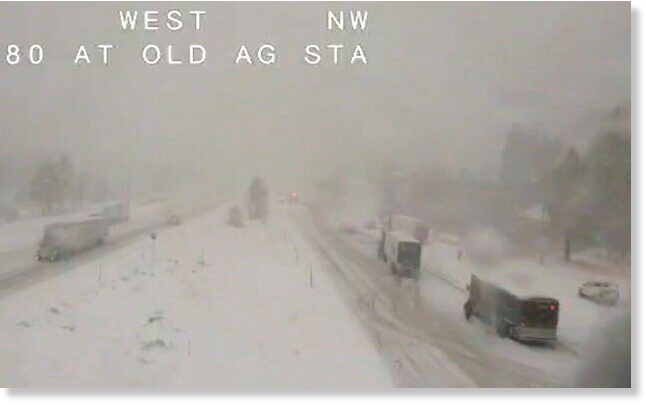
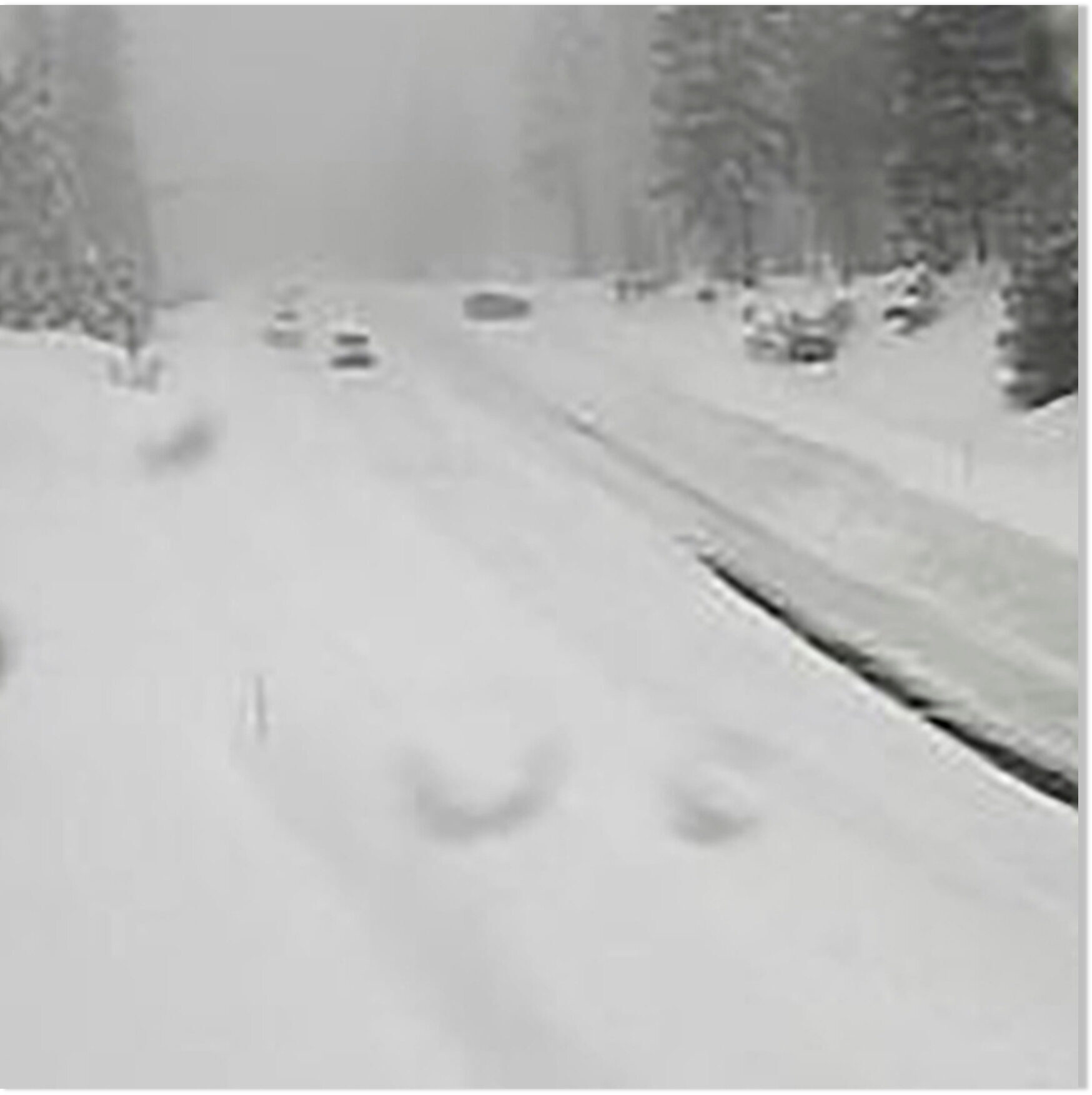
The storm already made for icy and dangerous conditions on key roadways, with authorities on Saturday closing down a long stretch of Interstate 80, from Colfax in Northern California to Stateline, Nevada, due to "blowing snow & near-zero visibility," Caltrans said on Twitter.

The Tahoe Basin and the Eastern Sierra are seeing snowfall totals that are typically recorded later in the winter, in January.

"The snowpack is about 225% of normal, so it's more than twice what we'd be expecting this time in December," said Mark Deutschendorf, forecaster at the National Weather Service office in Reno.

"It looks a lot like Christmas out here," Deutschendorf said. "It didn't come with a lot of wind, and it stuck to everything. It's like a picture postcard."

While he noted the snow totals so far are impressive, Deutschendorf said he is "cautiously optimistic" about this precipitation putting a big dent in the state's drought.

"We had a similar run of storms last year. We had a nice head start, and then January through March were incredibly dry," Deutschendorf explained.

In California, 48 inches of snow fell in Twin Bridges in a 48-hour period, 46 inches fell in Tahoe-Donner, 45 inches in Donner Peak and 44 inches at Palsades Tahoe Ski Base.

"We're Buried," the Palisades Tahoe Ski Resort wrote on its website Sunday, sharing photos of thick snow covering the ski resort in Olympic Valley, California.

"This is definitely a storm to remember
. We've now received 7.5 feet of snow since December 1st. Plus, in just 24 hours from Saturday morning to Sunday morning, we received more than 35 inches of snow — the 6th largest snowfall total in 24 hours that we have on record," resort operators wrote.

And in Southern California, residents were under warnings and watches amid heavy rain and localized flooding.

CNN's Andy Rose contributed to this report.
 
Back
Top Bottom