You are using an out of date browser. It may not display this or other websites correctly.
You should upgrade or use an alternative browser.
You should upgrade or use an alternative browser.
The Ice Age Cometh! Forget Global Warming!
- Thread starter Gaby
- Start date
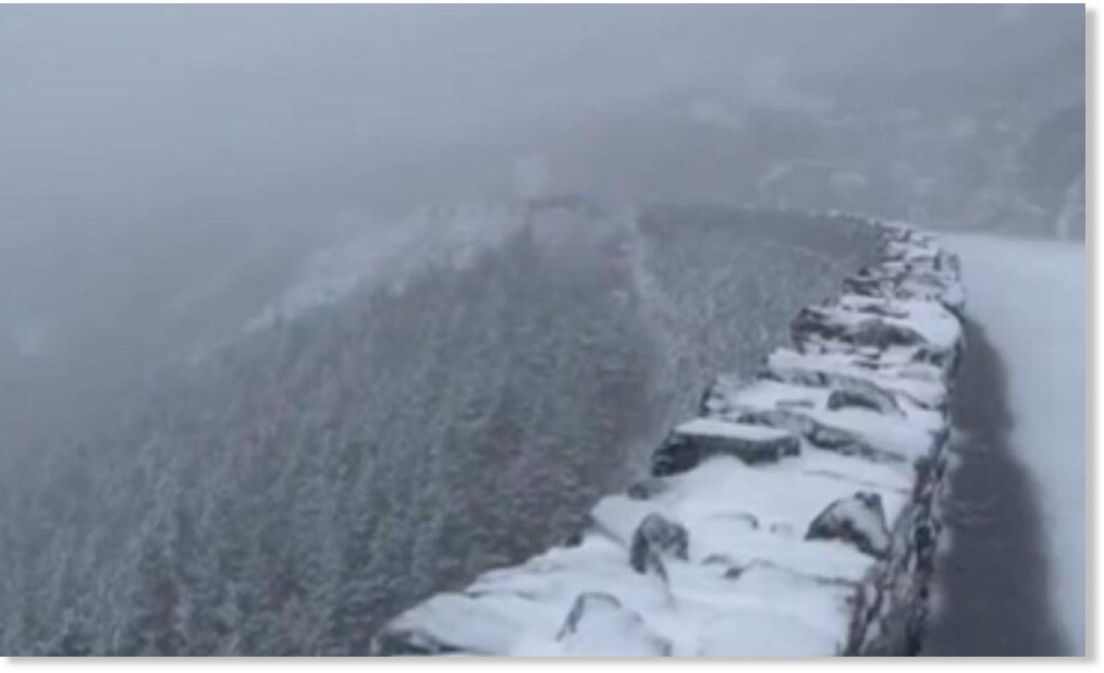
Early snowfall in the Pyrenees bombs the climate models of global warming.
 www.rt.com
25 Sep, 2022 10:08
www.rt.com
25 Sep, 2022 10:08


 www.sott.net


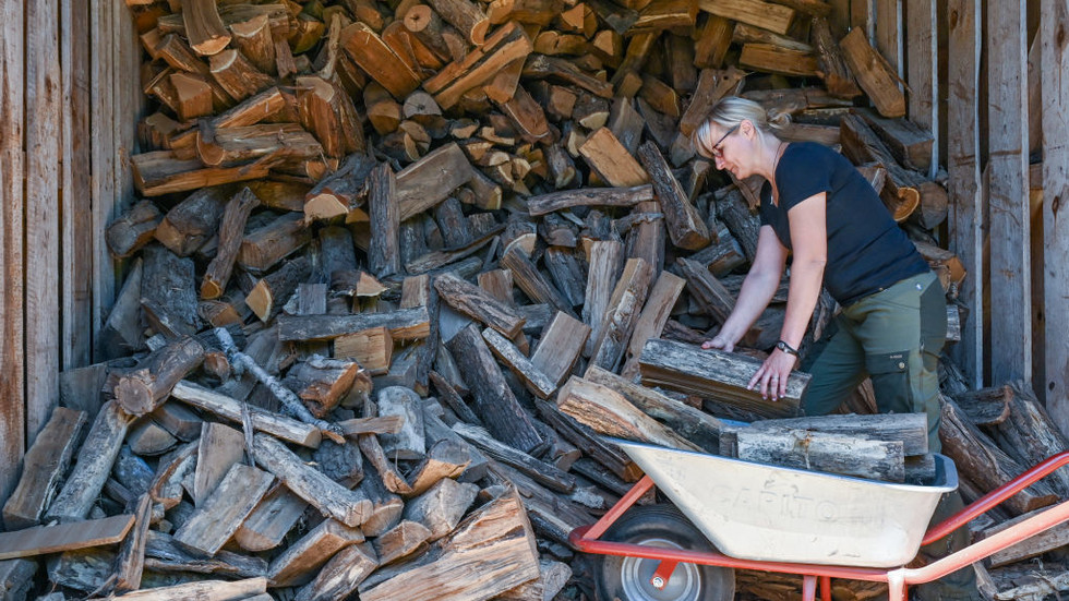
German firewood prices skyrocket – data
Prices for firewood in Germany have been soaring due to growing demand, according to official data
Prices for firewood and wood pellets in Germany spiraled 85.7% in August compared to the same month last year, the Federal Statistical Office (Destatis) reported on Thursday.
The figures show that firewood costs were growing much faster than consumer prices in general, which were up by 7.9% during the same period.
“Reasons for the above-average price rise for firewood and wood pellets are an increase in demand, as well as higher purchase prices and transport costs in the wood industry,” the statistics office explained.
It also noted that more people in Germany were turning to firewood as an alternative way to heat their homes amid surging energy prices.
Germany, the European Union’s largest economy, has been grappling with an energy crisis amid the halt in Russian natural gas supplies. Last month, Berlin revealed a series of steps aimed at reducing gas consumption during the upcoming heating season. The measures include lowering the heating temperature in offices and public buildings, with the exception of social institutions such as hospitals, from 20 to 19 degrees Celsius. Businesses, including major retailers, have already started reducing their use of power.
READ MORE: Power costs in Germany hit historic highs
The spike in energy costs has been hurting households and businesses across the EU. Other European countries have also started introducing drastic measures to limit energy use, such as banning outside lighting for buildings and lowering indoor heating temperatures.
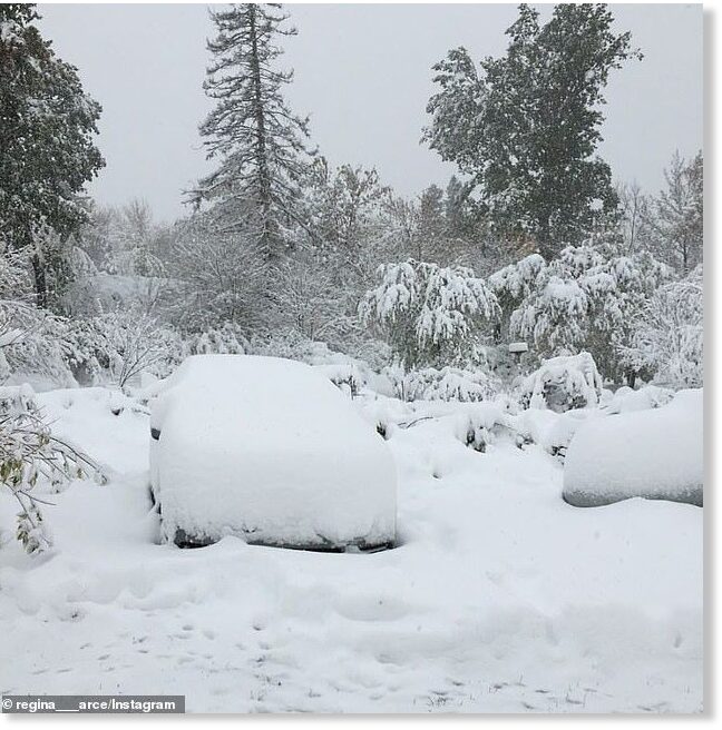
Early snow in September falls on east coast ski resorts -- Sott.net
Whiteface, NY, posted a video to Facebook this morning showing white stuff falling out of the sky and blanketing the ground. And it looks fantastic. Sugarbush, VT, also shared a video of it snowing. Awesome. Winter's coming. And not just to the...
www.sott.net
Last edited:
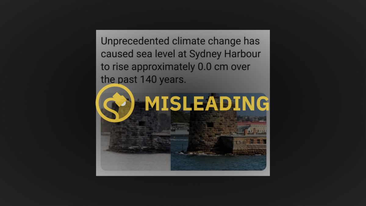
Snopes has fact checked this and gave it a resounding FALSE... hehe.
But it seems according to their records, the increase is very small, (and probably falls outside of the + or - error).
 www.snopes.com
"To say that the sea level in the Sydney, Australia region have not risen since the 19th-century is false. While sea level rise in that specific area is less than the global average, NOAA reports that the relative sea level trend is .75 millimeters each year, or .029 inches. It’s an admittedly small level and one that may not be detectable by the naked eye, but it’s a rise nonetheless."
 Sea level trends of Fort Denison in Sydney Harbor, Australia. NOAA
But it seems according to their records, the increase is very small, (and probably falls outside of the + or - error).
These Pics of Sydney Harbor Don’t Debunk Sea Level Rise, Climate Change
Iterations of this meme have been around since at least 2018.
www.snopes.com
"To say that the sea level in the Sydney, Australia region have not risen since the 19th-century is false. While sea level rise in that specific area is less than the global average, NOAA reports that the relative sea level trend is .75 millimeters each year, or .029 inches. It’s an admittedly small level and one that may not be detectable by the naked eye, but it’s a rise nonetheless."
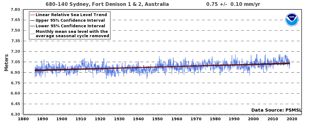 Sea level trends of Fort Denison in Sydney Harbor, Australia. NOAA
Early snowfall in the Pyrenees bombs the climate models of global warming.
German firewood prices skyrocket – data
Prices for firewood in Germany have been soaring due to growing demand, according to official data
An interrelated aside (especially in light of Russian pellet and lumber markets being shut down - sanctioned):

Ban On Russian Wood Pellet Exports Would Have Consequences On Waste - World Bio Market Insights
Starting July 10, the Russian wood pellet exports to Europe will be completely stopped. From this date, EU sanctions will come into effect, limiting the supply of wood products from Russia and Belarus. This is the main market for Russian companies. According to Lesprom Analytics, in 2021 the...
North American markets, right on cue, will climb:
European demand for wood pellets could fuel increased North American exports | Woodworking Network
Europe’s demand for wood pellet is expected to increase by 30 to 40 percent over the next five years, according to a new report released by Wood Resources International (WRI).
 www.woodworkingnetwork.com
Chad
The Living Force
I was looking to see if there were any weather maps showing the relatively sudden and notable cooling across Europe in the last week or so and came across the following, and which are provided by a meteorologist who is known for pushing the global warming/climate crisis nonsense.
Cooler than usual weather across Europe following the heatwaves and droughts of spring and summer. Record cold temperatures in a few parts of Greece on 26th September.
ADDED: The temps, at least in France, are set to move back up into mid-20C for a week or so.
Record cold in Greece reported on 26th Sept - some areas colder than the UK:
Last edited:
Portions of Midwest, Northeast in line for first snowflakes of the season
Updated Oct. 13, 2022, 5:25 PM EAT Snip:
A large swath of the United States will transition from a fall to winterlike pattern in the coming days, and some regions will have the chance to get their first snowflakes of the season, AccuWeather forecasters say.
The first of multiple cold fronts that will have the potential to produce severe weather in the East on Thursday will bring lower temperatures in its wake. Farther to the west and north, a much stronger push of cold air will arrive. Much colder air began to pour into the northern Plains on Wednesday, and a few snowflakes started to fly in portions of North Dakota and northern Minnesota on Wednesday night.

On this image captured on Thursday morning, Oct. 13, 2022, a storm system was visible that was producing rain and wet snow in portions of Minnesota, Wisconsin and the Upper Peninsula of Michigan. (AccuWeather Enhanced RealVue™ satellite)
Some of the coldest air so far this season will push across the northern Plains before the end of this week. Although snow on Wednesday night did not accumulate, that may not be the case on Thursday. Northern Minnesota could get 1-3 inches of snow from late Thursday night into Friday, but residents should not need to break out the shovels from storage quite yet, according to AccuWeather meteorologists.
"Upcoming snowfall is unlikely to accumulate on roads and sidewalks given how warm the ground still is, with snow largely just sticking to grassy areas and car tops," said AccuWeather Meteorologist Adam Sadvary.

That said, any heavier burst of snow could briefly cause sidewalks and less-traveled roads to become slushy. This would especially be the case in areas that are typically in the shade during daylight hours.
Any snow accumulation should melt on Friday as temperatures climb above freezing. Northern Minnesota, far northern Wisconsin, the Upper Peninsula of Michigan and even northern Lower Michigan could still have a mix of rain and snow showers on Friday, but the snow should melt on contact.
AccuWeather RealFeel® Temperatures will hover at levels more typical of mid-November over much of the region on Friday and may struggle to rise above 40 over parts of the Upper Midwest.
A mix of rain and wet snow showers may continue into Friday night and Saturday in northern portions of Minnesota, Wisconsin and Michigan.

Another cold front will be diving into the northern portions of the Plains and Great Lakes by Sunday.
"A potent cold front will push a surge of cold air across the Great Lakes region into late this weekend," said Sadvary.
Unlike the preceding air mass, the air that arrives late this weekend will dive much farther southeastward. By Monday, colder air will be pivoting into the Northeast.
"Early next week, chillier, November-like air will be able to spread across much of the Northeast," said Sadvary.
Snip:
The official start of winter is just over two months away, and even though many Europeans may be getting settled into fall routines, AccuWeather's team of long-range meteorologists has already pieced together an outlook for what Old Man Winter will bring to Europe this upcoming season.
Climbing electricity and gas costs across the continent are putting additional pressure on the prospect of what this winter will bring. Periods of cold weather could mean a ripple effect throughout different aspects of the European economy. It could bring long-lasting impacts to the day-to-day lives of residents as well as repercussions to tourism and commerce that can expand on a global level.
This winter season, experts say that the overall pattern will be largely influenced by La Niña, an oceanic and atmospheric phenomenon that is the cold counterpart to El Niño. During La Niña, unusually low ocean temperatures expand across the Equatorial Pacific, which in turn creates an ocean-atmospheric feedback system that can impact weather across the globe--particularly the winter temperature and snowfall patterns.
Climatologists say La Niña is still undergoing strengthening and is predicted to continue through the rest of the autumn and winter months.
"La Niña is expected to peak in November," AccuWeather Lead International Meteorologist Jason Nicholls said, adding that the El Niño Southern Oscillation (ENSO) signature should return to a neutral phase -- neither La Niña or El Niño -- in January. Despite that change during the latter part of the season, atmospheric conditions should remain La Niña-like throughout the entirety of winter due to a lag between the climate phenomenon and altered weather conditions.
What does this mean for the 2022-2023 winter outlook across Europe? Since this winter is the third consecutive winter season under the influence of La Niña, this season may bring a handful of similarities to last year's winter weather. However, AccuWeather forecasters say that this year contains a rare piece of the puzzle that recent years have not.
“A triple La Niña has occurred only three times since record-keeping began, the most recent being the start of the century from 1998 to 2001,” explained AccuWeather Senior Meteorologist Alan Reppert. By looking back at the few times in recent history when there were three La Niña winters in a row, forecasters can analyze these unique years and use them as part of their toolkit to help piece together what this winter may hold.
How cold will it get this season, and which areas can expect stormy conditions? AccuWeather meteorologists answer that and more in a region-by-region breakdown below.
Southern Europe to take brunt of potent storm
AccuWeather forecasters say there are indications that the general storm track this winter will often aim for southern Europe.
Locations across Portugal, Spain, southern France, Italy and the Balkans stand a greater chance of receiving more frequent rain and wind-driven events than other parts of the continent. In some ways, residents from the Iberian Peninsula to southeastern Europe could see some similarities to the previous two years.
This could mean an increased risk for heavy rain events, especially in southeastern France, north-central Italy and the western Balkans. Those living in cities, such as Venice, Italy, should closely monitor any storms in the area this winter due to their location's vulnerability to flooding. A dominant southerly storm track across Europe would also mean the potential for higher snowfall along the southern slopes of the Alps, explained Roys.
Windstorms are known for bringing damaging winds, torrential rainfall and even unloading snow in higher terrain. Last year, many of the named storm events in Spain and Portugal occurred later in the windstorm season in the springtime. However, numerous impacts from Storm Blas were felt during the first half of November across portions of eastern Spain and southern France.
Blas was named by Agencia Estatal de Meteorología (AEMET), the Spanish Meteorological Agency, on Nov. 5, 2021. The storm spread heavy rain and gusty winds to the eastern coast of Spain before tracking over the western Mediterranean and bringing additional rain and wind to parts of Algeria and France.
Blas was named by Agencia Estatal de Meteorología (AEMET), the Spanish Meteorological Agency, on Nov. 5, 2021. The storm spread heavy rain and gusty winds to the eastern coast of Spain before tracking over the western Mediterranean and bringing additional rain and wind to parts of Algeria and France.

Two snowmen frame the snow-draped dome of St. Peter Basilica. The snow blanketed ancient arches in the Roman Forum. (AP Photo/Alberto Pellaschiar)
Mountainous areas that can have higher snowfall totals this winter over the Iberian Peninsula include the Cantabrian Mountains, Central System and Pyrenees Mountains across northern and central Spain. The upcoming pattern could lead to ideal stretches of weather for area ski resorts and winter vacation destinations. However, low-lying areas outside the higher terrain will also stand a chance of getting normal to slightly above-average snowfall amounts as temperatures drop throughout the winter.
Following a remarkably dry summer in some regions with periods of sweltering temperatures, the yields from crops such as maize (corn), sunflower, sugar beet, potatoes and soybeans took a direct hit, according to the European Union’s crop monitoring service MARS. Experts have noted that the milder weather and periods of much-needed rainfall that arrived in some regions by late summer came too late for it to benefit many summer crops significantly. The prospects for this winter's growth and the upcoming harvest have moved into the spotlight.
Europeans have rising concerns that dry soil and depleted water reservoirs across southern Europe will need above-average winter precipitation to be restored. With this in mind, winter is typically the wettest season across this part of the continent, and the pattern favors rounds of unsettled weather that could help to put a dent in the ongoing drought. However, it is not expected that the upcoming stormy pattern could completely erase the drought. It may take years of above-average rainfall seasons to replenish the current low water levels.
Temperatures will likely trend near normal to slightly above normal across southern Europe this winter. However, periods of unsettled weather can be accompanied by spells of cooler weather, according to Reppert.
United Kingdom and Ireland can face cold bursts
By the start of December 2021, parts of the United Kingdom and Ireland had already observed some impacts from windstorms, including the named storms Aurore, Arwen and Barra. Storm Arwen was the notable storm that trapped 61 concertgoers inside the Tan Hill Inn, England's highest pub, for several days in late November 2021.
Last winter in mid-February, Storm Eunice brought substantial damage to infrastructure across the United Kingdom. The O2 Area's roof in London was badly torn by extreme wind gusts during this period. The Needles, a landmark in southern England, observed a wind gust of 122 mph from Storm Eunice, which the U.K. Met Office confirmed as the highest wind gust ever reported in England. To put the strength of winds into perspective, a Category 3 major hurricane in the Atlantic has winds ranging from 111 to 120 mph.
Average temperature anomaly in Europe for December/January/February according to CFSv2. Despite the uncertainties of these long-term forecasts, if they materialize, it will be catastrophic considering the energy crisis. A "normal" winter will already be problematic.
Attachments
Arctic Blast To Blanket Eastern Half Of US Next Week
"Unseasonably cold weather begins Monday and could last through the week and extend down to the Gulf of Mexico. There's also a risk of snow across the Great Lakes, Midwest, and New England."
"AccuWeather's models expect temperatures to dive 10-20 degrees Fahrenheit below average for the first half of next week for the entire eastern half of the country."
Arctic Blast To Blanket Eastern Half Of US Next Week | ZeroHedge
ZeroHedge - On a long enough timeline, the survival rate for everyone drops to zero
 www.zerohedge.com
Up to 16 inches of early snow, fierce gales, pounding surf slap northern Wisconsin, Michigan
Severe wintry October storms dumps more than a foot of lake-effect snow The season's first major lake-effect snow event has dumped more than a foot of snow on Lake Superior's leeward shores. And up to another foot of snow could fall in some...
www.sott.net
Up to 16 inches of early snow, fierce gales, pounding surf slap northern Wisconsin, Michigan
Severe wintry October storms dumps more than a foot of lake-effect snow
The season's first major lake-effect snow event has dumped more than a foot of snow on Lake Superior's leeward shores.
And up to another foot of snow could fall in some spots.
Parts of northwestern Wisconsin and Michigan's Upper Peninsula picked up more than a foot of snow so far. Marquette set a new daily snowfall record Monday.
Here are some select snowfall reports from the area.
Herman [Baraga Co, MI] PUBLIC reports SNOW of 9.00 INCH at 12:00 PM EDT -- SPRUCE AND PINE TREES DOWN IN HERMAN. FRUIT TREES ALSO DAMAGED AT CO-OP STATION /HERM4/. HEAVY AND DENSE WET IS FALLING AND OBSERVED ON THE GROUND.
1 ESE Bergland [Ontonagon Co, MI] CO-OP OBSERVER reports SNOW of 11.40 INCH at 8:00 AM EDT -- CO-OP OBSERVER STATION BERM4 BERGLAND DAM.
2 NW Wakefield [Gogebic Co, MI] PUBLIC reports SNOW of 12.00 INCH at 2:15 PM EDT -- ESTIMATED SNOWFALL SO FAR AT THE SNOWRIVER MOUNTAIN RESORT NEAR WAKEFIELD. REPORT VIA SOCIAL MEDIA.
1 W Ironwood [Gogebic Co, MI] PUBLIC reports SNOW of 14.30 INCH at 4:46 PM EDT --
Gile [Iron Co, WI] CO-OP OBSERVER reports SNOW of 16.00 INCH at 10:40 AM CDT -- AN ADDITIONAL 7 INCHES OF SNOW HAS FALLEN SINCE 5 AM CDT. THIS BRINGS THE STORM TOTAL SNOWFALL TO 16 INCHES.
Flooding surf
High winds over 50 mph drove waves of 10 to 13 feet that caused flooded streets near the shoreline in Marquette, Michigan.
Temperature extremes: Tens of millions of people under frost and freeze alerts as cold temperatures hit US Deep South
The cold air that's led to snow and sub-freezing temperatures across the Midwest and Great Lakes in the last few days is spreading across the southern United States. Over 75 million Americans are under frost or freeze alerts as the cold weather...
www.sott.net
------------------------------------------------------------------------------------------------------------------------------
Temperature extremes: Tens of millions of people under frost and freeze alerts as cold temperatures hit US Deep South
The cold air that's led to snow and sub-freezing temperatures across the Midwest and Great Lakes in the last few days is spreading across the southern United States.
Over 75 million Americans are under frost or freeze alerts as the cold weather moves south.
The temperature in Jacksonville, Florida, reached 42 degrees on Wednesday, with a wind chill that brought the temperature down to 37 degrees Wednesday morning, which marks the earliest recorded wind chill value in the 30s in Jacksonville's fall season.
On Wednesday morning, dozens of records were tied or broken.
Austin, Texas, hit 38 degrees; Jackson, Mississippi, reached 30 degrees; Charlotte, North Carolina, tied its record low of 30 degrees; Kansas City, Missouri, dipped to 25 degrees; and Cedar Rapids, Iowa, hit a low of 16 degrees.
In the Great Lakes region, heavy snowfall combined with leaves still on trees caused many branches to fall on power lines leaving thousands of customers without electricity.
Up to 18 inches of lake-effect snow fell in northern Wisconsin on Monday. Around 18.1 inches of snow fell in the Upper Peninsula of Michigan on Monday and Tuesday, breaking the 2-day snowfall record, the NWS Marquette said.
Other parts of the U.S. aren't experiencing the cooler weather, as Alaska and southern California are both unseasonably warm.
In Alaska, the cities of Juneau, Sitka, Ketchikan, Yakutat, Haines, and Skagway have all had their warmest start to October on record.
The National Weather Service issued a heat advisory for parts of Southern California, with temperatures rising into the mid-90s from San Diego to Anaheim this afternoon.
Last edited:
Russian Scientists Forecast Cooling, Thicker Ice Over The Coming Years; Putin Is Hoping For A Cold Winter; + Hundreds Of Low Temperature Records Fall Across The U.S. - Electroverse
"The Sun defines the climate, not carbon dioxide" ... "we are entering a stage of certain chilling, which is related to the 70-year chilling-warming cycle."
Russian scientists, in the relevant fields, have long predicted cooling due to low solar activity. Russia knows where global temperatures are headed. It could be argued that their recent geopolitical maneuverings are tied to this.
“The Sun defines the climate, not carbon dioxide,” so says eminent Russian space scientist, Habibullo Abdussamatov (Dr. Sc. – Head of Space research laboratory of the Pulkovo Observatory).
Observations of the Sun show that carbon dioxide is “not guilty” for the steady increase in temperature observed over the past few decades, he continues, and that what lies ahead in the coming years is not warming but a global and very prolonged bout of cooling.
“We should fear a deep temperature drop — not catastrophic global warming,” warns Abdussamatov, who was one of the researchers featured in the 2009 U.S. Senate Report of More Than 700 Dissenting Scientists Over Man-Made Global Warming.
“Humanity must survive the serious economic, social, demographic and political consequences of a global temperature drop, which will directly affect the national interests of almost all countries and more than 80% of the population of the Earth.”
Abdussamatov (2012) … for more.
Although the most prominent, Abdussamatov is far from the only Russian scientist forecasting cooling.
Alexander Makarov, director of the Arctic and Antarctic Research Institute, told reporters this week that lower air temperatures and much larger volumes of ice are expected in the Arctic over the coming years.
“According to certain estimations, before 2050, ice in the Arctic will remain 100%,” he said. “Moreover, the forecasts say we are entering a stage of certain chilling, which is related to the 70-year chilling-warming cycle. In fact, within a few years, the situation along the Northern Sea Route will change rather substantially.”
Answering claims of so-called ‘catastrophic anthropogenic global warming’, Makarov points out that ice conditions are not changing as unambiguously as the models foretold, noting that there is no linear decrease in ice.
“This year, at the end of August, we saw more ice in the Chukchi Sea — to the highest levels in over 20 years,” added Makarov.
Top Climate Scientist Slams Climate Alarm: Carbon Dioxide Is A “Particularly Ridiculous” Choice As A Pollutant
PUTIN IS HOPING FOR A COLD WINTER
Across Europe, governments are scrambling to prevent blackouts this winter. But success will largely be determined by the weather.
Western analysts say Putin is hoping for a cold winter after cutting Russian gas exports to Europe.
Another cold season, like that suffered in 2010/2011 or something akin to 2018’s “Beast from the East”, would likely result in untold hardships that could weaken EU resolve in the Ukraine.
“Europeans will go through the worst of it this winter,” said Eliot A. Cohen, a war historian and security expert at the the Center for Strategic and International Studies at Johns Hopkins University.
In recent months, nations have slashed their gas consumption in order to save supplies for winter. Europe has been racing to fill up its strategic reserves, buying in extra supplies at record prices from the likes of Algeria, Qatar, Norway and the United States.
The measures have worked. As it stands, EU stocks are at around 90% capacity: “Europe is well-placed to go through the winter under normal weather conditions,” said Alireza Nahvi, a research associate at Wood Mackenzie.
Seasonal weather forecasts have become unusually important.
Europe’s Copernicus Climate Change Service says it’s still too early to make confident predictions re. the upcoming winter; in the same breath, though, the service adds that initial indications suggest that it will be warm overall. It must be noted, however: this government-funded agency uses data from the likes of the ‘warm-mongering’ UK Met Office and Météo-France, meaning anything it says should be taken with a handful of salt. Much like USDA crop reports, the aim of this Copernicus is to settle markets and push an agenda, not to roil them with unwanted realities.
To conclude, a winter with average temperatures combined with a gas reduction of 9% should see Europe make it through the winter months without any major disruptions, so says the International Energy Agency (IEA), a consultancy financed by Western nations, who recently ran the numbers.
However, if the continent suffers a winter that is colder-than-average, even slightly, that will put immense pressure on the gas system,” cautions Gergely Molnar, an IEA gas analyst, with brownouts/blackouts during the coldest stretches of the year likely.
HUNDREDS OF LOW TEMPERATURE RECORDS FALL ACROSS THE U.S.
As predicted —nailed a week ago by the GFS— a truly fierce Arctic outbreak has gripped much of the United States.
And while the AGW Party and their MSM lapdogs point to the pocket of heat in the Northwest and declare a ‘cLiMaTe EmErGeNcY’, the fact remains that a bout of record-breaking, unprecedented cold is sweeping two-thirds of the CONUS.
Over the past 24-hours alone, hundreds of low temperature benchmarks have been busted:
Rather than evidence of CO2-induced ‘cLiMaTe ChAnGe’, however, North America’s current setup demonstrates a low solar activity-induced weakening of the jet stream — from its straight ZONAL flow to a wavy MERIDIONAL one:
‘Swings between extremes‘ become the predominant feature during bouts of reduced solar output, with your ‘extreme’ determined by which ‘side’ of the jet stream you’re on: If you’re located ‘above’ the JS, you’re on for record-challenging cold dragged down from the Arctic, whereas if you’re ‘under’ it, you’re set for anomalous heat pulled up from the tropics (in the NH).
What alarmists call ‘cLiMaTe ChAnGe’ can be fully explained by this mechanism — a wavy jet stream exaggerated by low solar activity:
This setup will be the driving force of America’s weather next week, too.
Looking at the latest GFS run (shown below), the Northwest’s anomalous heat is about to ‘swing’ to record-challenging cold, cold that will also extend to central and eastern regions of the CONUS as the month progresses and Halloween nears:
GFS 2m Temperature Anomalies (C) Oct 24 – Oct 29 [tropicaltidbits.com].
The early-season snow totals are just as impressive, with feet forecast for states such as Montana, Wyoming, Utah and Colorado:
GFS Total Snowfall (inches) Oct 19 – Nov 4 [tropicaltidbits.com].
Winter is here for many.
I hope you heeded the warnings and prepared.


"With its strong preference to peak during boreal winter and rapidly decay in spring (known as “phase-locking”), and quasi-periodic oscillations of 2–7 years, historically, ENSO rarely maintains for long in either its cold phase (La Niña) or warm phase (El Niño). However, since the turn of the current century, three instances of so-called “double dip” La Niña events have occurred, in 2007–09, 2010–12 and 2020–22."
lilies
The Living Force
Amazing how little public science advancement was made to develop and secure new heating technologies in the last 100 years.Russian scientists, in the relevant fields, have long predicted cooling due to low solar activity. Russia knows where global temperatures are headed. It could be argued that their recent geopolitical maneuverings are tied to this.
Instead Tools of Oppression: Big Brother Satellites, military war tech, computers, gene-editing - tools to help totalitarian control is supported & financed to a maximum level.
While groundbreaking and in all-conditions absolutely working, new technologies that do not rely on fossil fuels and could enable billions of people to heat & light their homes & cook are completely missing.
This alone proves the unwashed masses of Sheeple are sentenced to extinction by the Super Rich.
David DuByne of ADAPT 2030 update:
Well done. Here are a few of his points:
"Resource Nationalization" Countries will have stopped exporting food-goods by November/December of this year.
Year without summer has already started in New Zealand.
Finances being swept up around the globe.

 www.bitchute.com
Well done. Here are a few of his points:
"Resource Nationalization" Countries will have stopped exporting food-goods by November/December of this year.
Year without summer has already started in New Zealand.
Finances being swept up around the globe.
(2/2) Our World Is In Freefall, What to Expect by Jan 2023
Get Your Gold IRA FREE Investor Guide Today! Click Below! https://www.patriotgoldgroup.com/download/silver-ira-investor-guide.html?src=7954844 Call (1-800-356-4470) Today! Freefall is a good way to describe the events from Summer 2022 leading to now, but what can we expect as closures and...
www.bitchute.com
Last edited:
Trending content
-

-

-
Thread 'Coronavirus Pandemic: Apocalypse Now! Or exaggerated scare story?'
- wanderingthomas
Replies: 30K -
