It's possible Greta will get her wish - planes, trains, and automobiles imbedded by unrelenting snow and ice!Travel has been disrupted on roads, trains and in airports after heavy snow, with one man dead
You are using an out of date browser. It may not display this or other websites correctly.
You should upgrade or use an alternative browser.
You should upgrade or use an alternative browser.
The Ice Age Cometh! Forget Global Warming!
- Thread starter Gaby
- Start date
It's possible Greta will get her wish - planes, trains, and automobiles imbedded by unrelenting snow and ice!
Assuming she even makes it across the Atlantic. This is not a good time of year to sail that route, and the weather is already nuts out there.
Maybe these guys can help her out:Assuming she even makes it across the Atlantic. This is not a good time of year to sail that route, and the weather is already nuts out there.
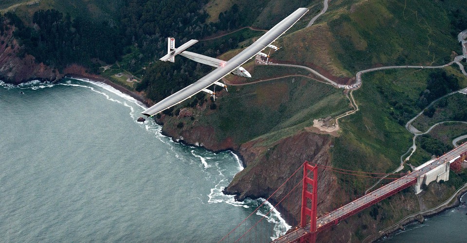
Somebody supplied that yacht - why not a solar plane? And it's not like she's going to miss any school!Flying Around the World in a Solar Powered Plane
The journey took a very long time—505 days to fly 26,000 miles (42,000 km) at an average speed of about 45 mph (70 kph)—but pilots Bertrand Piccard and Andre Borschberg successfully landed the Solar Impulse 2 aircraft in Abu Dhabi on Tuesday, after flying around the world using only the power of the Sun. Solar Impulse 2 is a solar-powered aircraft equipped with more than 17,000 solar cells that weighs only 2.4 tons with a wingspan of 235 ft (72 m). Technical challenges, poor flying conditions, and a delicate aircraft all contributed to the slow pace. Gathered here are images from the record-setting circumnavigation, undertaken to help focus the world’s efforts to develop renewable energy sources.
Flying Around the World in a Solar Powered Plane
Pilots Bertrand Piccard and Andre Borschberg successfully landed the Solar Impulse 2 aircraft in Abu Dhabi on Tuesday, after flying around the world using only the power of the Sun.www.theatlantic.com
Maybe not the best time of year for a solar plane ride over the Atlantic. How about under it? Nuclear submarines are carbon free (if you don't count what's being exhaled/eliminated by the human operators)!the weather is already nuts out there.
From wiki:
A nuclear submarine is a submarine powered by a nuclear reactor. The performance advantages of nuclear submarines over "conventional" (typically diesel-electric) submarines are considerable. Nuclear propulsion, being completely independent of air, frees the submarine from the need to surface frequently, as is necessary for conventional submarines. The large amount of power generated by a nuclear reactor allows nuclear submarines to operate at high speed for long periods of time; and the long interval between refuelings grants a range virtually unlimited, making the only limits on voyage times being imposed by such factors as the need to restock food or other consumables.
Current generations of nuclear submarines never need to be refueled throughout their 25-year lifespans.[1] Conversely, the limited power stored in electric batteries means that even the most advanced conventional submarine can only remain submerged for a few days at slow speed, and only a few hours at top speed, though recent advances in air-independent propulsion have somewhat ameliorated this disadvantage. The high cost of nuclear technology means that relatively few states have fielded nuclear submarines. Some of the most serious nuclear and radiation accidents ever to occur have involved Soviet nuclear submarine mishaps.[2][3]
As we can see in the tweet below, it was rough on Wednesday. If nothing else, she gets some life experience in a hurry, if that will help? Following the other accounts in the above tweet, a youtube channel turned up:Assuming she even makes it across the Atlantic. This is not a good time of year to sail that route, and the weather is already nuts out there.
Sailing La Vagabonde. And a website: Sailing La Vagabonde | A Few Words Behind The Movies where there was a current map of the weather in the region they sail:
And their background:
We’re Riley and Elayna, an Australian couple documenting our journey traveling the world by sail despite no previous sailing experience. We’ve been filming it all on YouTube since 2014. We’ve crossed the Mediterranean, Atlantic, Caribbean, and Pacific, and are now raising our boy Lenny on our boat as well.
We’ve suffered terrifying storms, pirate scares, financial breakdowns, equipment failures, water shortages, and other interesting mishaps but we wouldn’t trade living on the Sea and going where the wind takes us for anything.
Greta is not the youngest, it looks like they have a baby on board. Apart from Greta, is it time to learn something about sailing, signs and times considered? In this thread we are maybe talking about ice breakers.
Last edited:
And from the following BOAT LIFE: The Exhaustion sets in.. 5 Days at Sea. Ep. 223 | Sailing La Vagabonde I guess she might have the opportunity to be helpful by helping to clean and cook.Greta is not the youngest, it looks like they have a baby on board.
Yep, the data for this time a year (for a 50 footer), is dangerous at best. As the open seas takes no prisoners.This is not a good time of year to sail that route, and the weather is already nuts out there.
This is what maybe, underway here. The current cloud cover continues unprecedented since the beginning of the year.
With damage control already active.
[Mini glacial period] Does Europe enter the mini glacial period after the US? https://youtube.com/watch?v=0n9LKAmho-s Increased radiative cooling due to thinning of the thermosphere and a decrease in solar radiation in the winter generate intense cold waves. If the snow and ice area increases due to intense cold waves, the albedo (sunlight reflectance) will increase and the cold will stay
Last edited:
lilies
The Living Force
WOW! There are large black areas in the Sun?! First time I've see it. Previous years it was only tiny dark spots, now have become large black areas, WOW!!
The forecast isn't too bad and these people who sail the boat have experience, though not that many small boats cross this time of the year.Yep, the data for this time a year (for a 50 footer), is dangerous at best. As the open seas takes no prisoners.
I looked at some web sites that informs about the weather at sea:
Wheather online
Ventusky What I like about this map is also that it shows very well where there is cold at the moment. The contrasts between warm and cold air can be dramatic.
On MarineTraffic: Global Ship Tracking Intelligence | AIS Marine Traffic there are quite a few ships in the Atlantic.
The forecast isn't too bad and these people who sail the boat have experience
Things are about to change in the coming days.

Dégradation pluvio-orageuse la semaine prochaine : le point ce dimanche
La goutte froide persiste sur la France en ayant tendance à se résorber progressivement. L'air frais persiste dans un contexte assez mou. Cela explique les gelées matinales que nous connaissons dans les secteurs déventés....
 www.meteolanguedoc.com
The cold drop persists in France, tending to gradually diminish. The fresh air persists in a rather soft context. This explains the morning frosts that we know in the déventés sectors. The degradation is reduced as expected this morning and tomorrow on the Roussillon with low rainfall. The change of weather is confirmed for the next week with a risk of degradation quite intense. Explanations.
As the depression fades slowly, a vast low-pressure system will slide from the Atlantic to France (see animation below). The transition will be short-lived before the introduction of a flow of South a little softer but especially more humid.
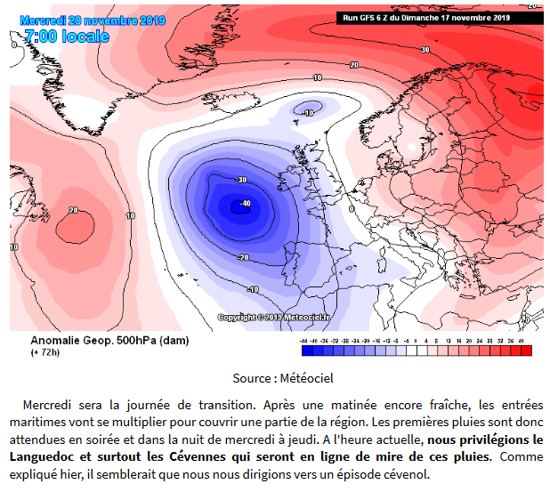
Wednesday will be the transition day. After a still cool morning, the maritime entries will multiply to cover a part of the region. The first rains are expected in the evening and in the night from Wednesday to Thursday.
At the moment, we favor the Languedoc and especially the Cevennes which will be in line of sight of these rains. As explained yesterday, it seems that we were heading for a Cevennes episode.
The situation could remain blocked for several days. Indeed, the episode that should begin between Wednesday and Thursday may persist until Saturday. Thursday and especially Friday will be the most watered days with many rainfall especially between Herault, Gard and the Cevennes. In view of a strong sea wind, the rains may be more heterogeneous on the plains to go hang on the reliefs where they will be abundant.

The models begin to agree (despite normal divergences at this time) on a lasting Cevennes episode between Thursday and Saturday. The Roussillon could also have rain but without consequences. Uncertainties still lie in the precise timing but also in the ability of thunderstorms to develop. Indeed, the instability will not, a priori, be very high. The risk of violent storms is not considered. However, the convective character of the rains will have an important role on the rainfall intensities.
The most plausible scenario reports moderate to punctually strong rainfall over the Cevennes reliefs. On the plains, rainy passages are expected but they can be interspersed with lulls. The first accumulations are 200 to 300 mm on the Cevennes spread over several days, 50 to 100 mm in the interior plains of the Hérault and Gard, rather 30 to 70 mm in approaching the littorals.
This first forecast will certainly be refined regularly in view of the uncertainties mentioned above.
Meanwhile:
Anyone crossing the Atlantic within such a nutshell, especially at this time of the year, is simply foolish and asking for trouble. The great ocean is certainly not something to take lightly in any shape, form or fashion. I think there is a lot to the notion, that if you don't approach natural phenomena like the oceans with the due respect and caution they deserve, you ask for big trouble. Heck, I've already a lot of respect and awe when confronted with relatively small waves at the beach. The ocean is breathtakingly awesome but at the same time breathtakingly dangerous and formidable. Greta and company don't strike me as the most aware and caring people in that respect.
Trending content
-

-
Thread 'Coronavirus Pandemic: Apocalypse Now! Or exaggerated scare story?'
- wanderingthomas
Replies: 30K -
-
