Translated from French by Microsoft
#Tempête of 7 june 1987 [2/2]-Brigitte Simonetta attempted to explain the phenomenon in the journal of Antenne 2 @claude_serillon but in a particularly confused way, mixing the notion of #tornade with that of #tempête
You are using an out of date browser. It may not display this or other websites correctly.
You should upgrade or use an alternative browser.
You should upgrade or use an alternative browser.
Tornadoes around the World
- Thread starter angelburst29
- Start date
Translated from French by Microsoft
Impressive

New details on suspected tornadoes that ripped through Minnesota
Bone Lake in Minnesota and Bone Lake in Wisconsin were hit hard.
More information is being learned about the tornadoes that ripped through areas west and north of the Twin Cities on Sunday afternoon.
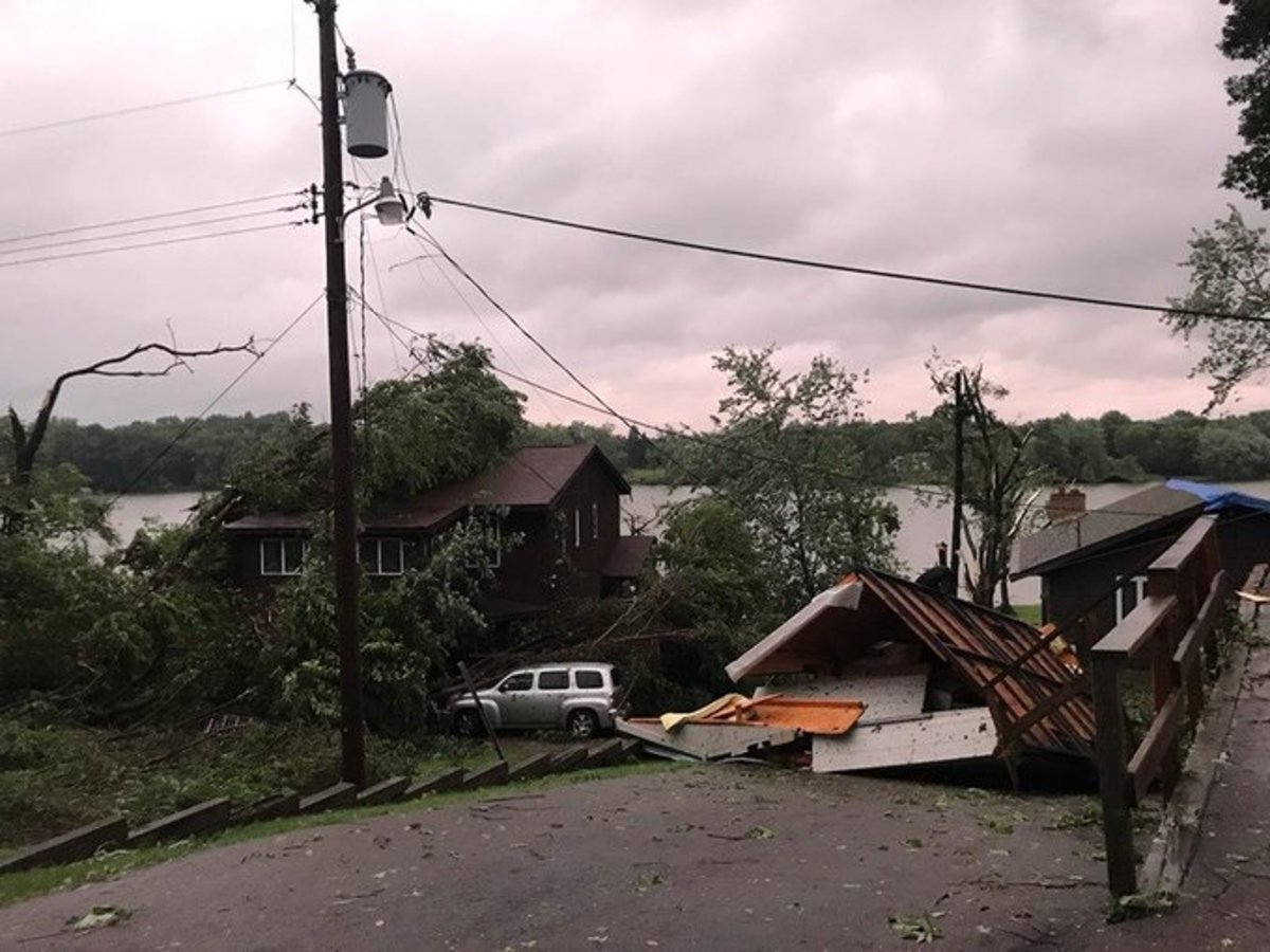
According to the Washington County Sheriff's Office, a suspected tornado that tore through a residential near Bone Lake west of Scandia (north of the Twin Cities) resulted in no injuries, but nine structures sustained significant damage, in addition to heavy tree damage in the area.
Jake Heitman tweeted video of the tornado, and it appears to be a large wedge rapidly moving through the Scandia area.
Washington County Emergency Management contacted the American Red Cross but no assistance for Scandia residents had been requested as of Sunday night.
Further to the northeast in Polk County, Wisconsin, a possible tornado shredded at least one farmstead. Briana Zellmer took video of the damage at her parents' home, describing the destruction as "horrendous."
"The most recent weather event affected the Bone Lake area in the Georgetown and Bone Lake Townships," said the Polk County Sheriff's Office in a Facebook post.
"While there was significant home and secondary building damage, no reports of injuries were received and no deaths have occurred. At this time, emergency responders have checked all residents and public roadwys are being cleared. We have not received conformation of a tornado from the NWS."
Another video shows immense destruction from the Bone Lake, Wisconsin twister.
Ironically, the apparent tornadoes did damage near Bone Lake in Minnesota, and near Bone Lake in Wisconsin.
Here's a map showing Scandia, with Bone Lake just to the northwest of town.
Bone Lake in Wisconsin is located about 40 miles northeast of Scandia.
tornado watch was issued by the National Weather Service at 2:50 p.m. and within 45 minutes there was a confirmed tornado on the ground near Biscay, which again dropped down near Silver Lake in McLeod County.
Video of that twister from storm chaser Michael Marz also appears to be a large cone tornado.
The National Weather Service in the Twin Cities will have damage survey teams in three areas on Monday to determine if damage was caused by tornadoes or straightline winds, and if it was tornado damage, how strong they were.
- Area 1: Biscay/Silver Lake areas in McLeod County.
- Area 2: Bone Lake near Scandia in Washington/Chisago counties.
- Area 3: Near Bone Lake in Polk County, Wisconsin.
Tornado Touchdowns Confirmed in Pinellas, Polk; Thousands Without Power
Residents in several Tampa-area locations are cleaning up after heavy rain, power outages — and extensive tornado damage.
PUBLISHED 5:44 AM EDT Oct. 19, 2019 UPDATED 3:22 PM ET Oct. 19, 2019

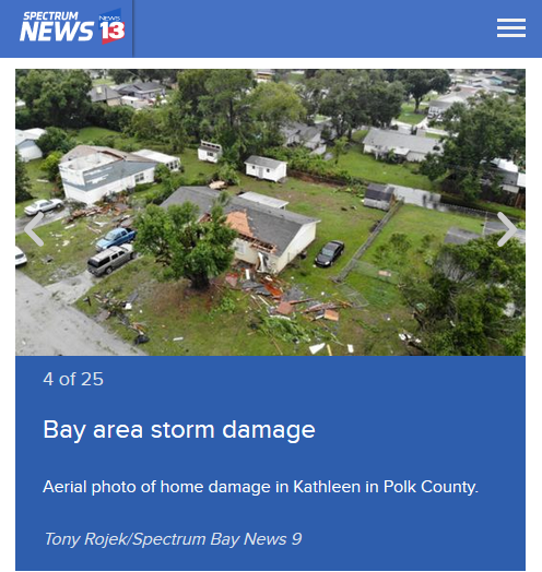
ST. PETERSBURG, Fla. — Officials have confirmed that extensive damage in Polk County late Friday night. was caused by an EF-2 tornado.
The tornado was one of two that hit the Tampa Bay area as Nestor came through Florida. Residents in several Bay area locations are cleaning up after heavy rain, windy conditions and — in some cases — power outages and damage.
Almost 10,000 Lakeland Electric customers lost power due to damage caused by the tornado which first touched down at Lakeland-Linder Airport and traveled north across I-4 and into Kathleen in Polk County.
Once the storm hit Kathleen, it damaged the roof of Kathleen Middle School. A tractor-trailer overturned on I-4 westbound at Polk Parkway as the tornado crossed the roadway.
The Polk County Sheriff's Office Emergency Communications Center received dozens of reports of damage to homes, windows, carports and barns.
Power lines and numerous trees were reported down or damaged in locations that included Knights Station Road, Highland Grove Drive, Willow Wisp Drive and Sunnyside Drive.
One Polk County resident said: "It sounded like a train coming through there. I could hear it whistling through the window ... it sounded like bombs going off.
"Just as quick as it came, it was gone," she said.
According to initial law enforcement reports, there have been no serious injuries reported to the Sheriff's Office or Polk County Fire Rescue.
Deputies remained on scene where there were power lines down in the roadway until Lakeland Electric could arrive and fix the downed lines as well as restore power.
Meanwhile, an EF-0 tornado with winds near 70 mph was confirmed in Pinellas County. It struck the Seminole area (Twelve Oaks Mobile Home Park) and produced minor damage.
The number of Duke Energy outages in Pinellas County was climbing before 8 a.m. There were about 2,000 customers without power in Seminole, with about 3,000 total in the county. By 11 a.m., however, the countywide number was down to about 1,000.
Tornado warnings were in effect much of Friday night, and tornado watches remained in effect until noon Saturday. A watch means tornadoes are possible in and near the area where it has been issued. A warning means a tornado has been sighted or indicated by weather radar and that there is imminent danger.
Several locations have experienced or may experience flooding. Those areas include: Clearwater, Largo, Seminole, Harbor Bluffs, Ridgecrest, Safety Harbor, Belleair, Redington Shores, Belleair Bluffs, Belleair Beach, Redington Beach, Indian Shores, North Redington Beach, Belleair Shore, Walsingham Park and Belleair Shores.
The worst of the weather happened east of Tropical Storm Nestor, which became the 16th named storm of the 2019 Atlantic stormseason on Friday afternoon.
Nestor is poorly organized, so the Spectrum Bay News 9 Weather Experts said don't focus on the center of the storm — most of the significant weather is well east of the center.
By this afternoon, conditions will begin to dry out. There will still be a few showers leftover but the frequency will decrease and the threat for tornadoes will end.
Another front approaches and stalls over our area Monday into Tuesday. This will lead to higher rain chances on Monday and Tuesday.
Stay with Spectrum Bay News 9 today for updates.
@MLMontpellier @MeteoLanguedoc Tornado of 20/10/19 herault probably on Aspiran seen from Puilacher
Many #tornades reported under the #orage currently circulating on the #Hérault (info transmitted by the storm hunter Vincent Deligny) between Pézenas and Clermont-l'Hérault. More information to come.
A caravan was torn off a vehicle pulling it, and projected on the other side of the road! Photo via Daniel Gauvin: https://facebook.com/photo.php?fbid

Dallas Tornado Causes Significant Damage Sunday Night
A large, damaging tornado caused significant damage in the heart of the Dallas-Fort Worth metroplex
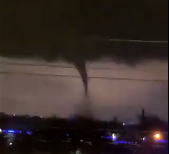
A large, damaging tornado caused significant damage in the heart of the Dallas-Fort Worth metroplex on Sunday night, leading to reports of injuries.
The tornado touched down around 7pm CDT near Dallas’ Love Field, or roughly eight miles northwest of downtown Dallas. It then stayed on the ground for approximately 10 miles, cutting through the heart of Dallas’ University Park neighborhood before crossing Interstate 635. The tornado then moved through the northern edge of Dallas County, including the suburbs of Richardson and Garland.
A separate tornado warning was issued for the southern side of Dallas County as well, though that storm didn’t produce any immediate reports of tornadoes.
Widespread reports of damage began to circulate on social media, particularly on the north side of the city.
On Sunday night, local authorities urged locals to stay off the roads in affected areas.
Video of the Tornado recorded in Colon Queretaro (Mexico) this afternoon of October 20, 2019. Credits Hugo Garcia
Edit add related:
Recent events in both weather and social unrest are just NUTS. Reminds me of the very first session with the Cs:
One naturally wonders if that was a prediction of a marker event? Like the 2014 "explosion" in Ukraine was the beginning of the total insanity that we live in today.
Q: (L) What are you here for tonight?
A: Prophecy.
Q: (L) What prophecies?
A: Tornadoes Florida - several.
Q: Where else?
A: Also Texas and Alabama.
Q: (L) When?
A: Sun is in Libra.
One naturally wonders if that was a prediction of a marker event? Like the 2014 "explosion" in Ukraine was the beginning of the total insanity that we live in today.
A destructive tornado touched down in the northeastern part of Dallas on Sunday night (Oct. 20), knocking out power for more than 150,000 residents and causing significant property damage. Though the tornado cut through a densely populated area, no storm-related deaths have been reported, according to the city's official website.
"We should consider ourselves pretty fortunate that we didn’t lose any lives, no fatalities, and no serious injuries," said Dallas Mayor Eric Johnson told The Washington Post. "Property damage, we’re not concerned about
The tornado was part of a series of severe storms reported from Texas to the Illinois-Missouri border yesterday, battering the region with hail, lightning, heavy rain and 70 mph (113 km/h) winds. The National Weather Service has yet to determine the intensity of the tornado that hit Dallas, but radar scans revealed powerful wind lifting debris more than 20,000 feet (6 kilometers) in the air, The Washington Post reported. (The height at which debris circulates is often indicative of a storm's strength.)
Sunday's violent maelstrom likely formed after a supercell thunderstorm — a violent storm with a deep, rotating updraft that can easily intensify into a tornado — collided with several smaller rainstorms north of the Dallas-Fort Worth airport on Sunday night (Oct. 20), according to the Post.
By 9 p.m. local time, radar scans of the storm revealed an ominous "debris ball" made of obliterated homes, businesses and other property, swirling about 2 miles high (3.2 km). Within the next 10 minutes, the debris reached a height of nearly 3 miles (4.8 km). The National Weather Service in Fort Worth labeled the storm "life threatening" and capable of "complete destruction."
The tornado did most of its damage in Dallas' Preston Hollows neighborhood — an affluent community that includes the home of former president George W. Bush and first lady Laura Bush. (They were both unharmed by the storm, a spokesperson said). Numerous homes, schools and businesses were destroyed by the storm, however, and the roads were littered with trees and downed power lines. Dozens of roads remain closed, and roughly 100 traffic lights are still without power, the city's website said.
Tornadoes form when winds of different temperatures and humidity meet. In the United States, this generally happens when warm, moist air from the Gulf of Mexico meets cool, dry air moving southward from Canada. Warm air likes to rise, but can sometimes get trapped under a block of cold air when two storm fronts meet. Unable to move upward, the warm air starts to rotate instead, sometimes pulling the cool air below it and intensifying into a spinning wind funnel that stretches from the ground to the sky.
While this storm was remarkably strong, tornadoes are not an uncommon occurrence in the overall region. Dallas County has been hit with about 100 twisters in the last 140 years, the National Weather Service reports, including 19 in the last decade.
Dates: September 24th – October 23rd
"We should consider ourselves pretty fortunate that we didn’t lose any lives, no fatalities, and no serious injuries," said Dallas Mayor Eric Johnson told The Washington Post. "Property damage, we’re not concerned about
The tornado was part of a series of severe storms reported from Texas to the Illinois-Missouri border yesterday, battering the region with hail, lightning, heavy rain and 70 mph (113 km/h) winds. The National Weather Service has yet to determine the intensity of the tornado that hit Dallas, but radar scans revealed powerful wind lifting debris more than 20,000 feet (6 kilometers) in the air, The Washington Post reported. (The height at which debris circulates is often indicative of a storm's strength.)
Sunday's violent maelstrom likely formed after a supercell thunderstorm — a violent storm with a deep, rotating updraft that can easily intensify into a tornado — collided with several smaller rainstorms north of the Dallas-Fort Worth airport on Sunday night (Oct. 20), according to the Post.
By 9 p.m. local time, radar scans of the storm revealed an ominous "debris ball" made of obliterated homes, businesses and other property, swirling about 2 miles high (3.2 km). Within the next 10 minutes, the debris reached a height of nearly 3 miles (4.8 km). The National Weather Service in Fort Worth labeled the storm "life threatening" and capable of "complete destruction."
The tornado did most of its damage in Dallas' Preston Hollows neighborhood — an affluent community that includes the home of former president George W. Bush and first lady Laura Bush. (They were both unharmed by the storm, a spokesperson said). Numerous homes, schools and businesses were destroyed by the storm, however, and the roads were littered with trees and downed power lines. Dozens of roads remain closed, and roughly 100 traffic lights are still without power, the city's website said.
Tornadoes form when winds of different temperatures and humidity meet. In the United States, this generally happens when warm, moist air from the Gulf of Mexico meets cool, dry air moving southward from Canada. Warm air likes to rise, but can sometimes get trapped under a block of cold air when two storm fronts meet. Unable to move upward, the warm air starts to rotate instead, sometimes pulling the cool air below it and intensifying into a spinning wind funnel that stretches from the ground to the sky.
While this storm was remarkably strong, tornadoes are not an uncommon occurrence in the overall region. Dallas County has been hit with about 100 twisters in the last 140 years, the National Weather Service reports, including 19 in the last decade.
- Photos: The Tornado Damage Scale In Images
- Tornado Chasers: See Spinning Storms Up-Close (Photos)
- Image Gallery: Moore, Okla., Tornado Damage - May 20
Dates: September 24th – October 23rd
Libra is a charged Zodiac sign that's often a provocateur of balance. It's an air sign of refreshing clarity, and many are intellectually oriented.
Libra has the distinction of welcoming Autumn with Fall Equinox, on or around September 21st.
It's the sign of the Mirror and knowing the Self by looking into the reflection -- either an actual mirror or the eyes of another person. That's why Libra is the sign of relating. Libra wonders, "Who am I in relation to her?"
Libra is hypersensitive to reactions and is expert at reading people. It's hard to get away with a lie with Libra, as they're sharp and spot fakery. Some become essayists or media observers. Others get drawn into beautification livelihoods, like design, fashion or the arts.
The Dark Side of Libra is being relentless with others, and needing attention all the time, even if it's negative. Close friends can feel on duty 24-7 for reactions, and be targets of ire if they say the wrong thing.
Some Libras avoid clashing with others and pretend everything's fine, even when it's clear they are barely holding it together. It's hard on Libra to go through dark nights of the soul, and trust that they will re-emerge stronger.
Teen Libras are very looks-conscious and hypersensitive to peer pressure. They may want to be popular, and have a super hard time if bullied or talked to in a harsh or vulgar way.
Recent events in both weather and social unrest are just NUTS.
Recently there was a tornado near Sacramento: Tornado near Sacramento
Apparently not as rare as I thought: Tornados in California
Last edited:
Trending content
-
-
-
Thread 'Coronavirus Pandemic: Apocalypse Now! Or exaggerated scare story?'
- wanderingthomas
Replies: 30K -

