Volcanoes Erupting All Over

New island discovered after major submarine eruption at Fukutoku-Oka-no-Ba, Japan

A new island has been discovered some 50 km (31 miles) south of Iwo Jima, Ogasawara Islands, Japan just three days after a major submarine eruption at Fukutoku-Oka-no-Ba volcano.

According to the Japan Meteorological Agency (JMA) the new island is approximately 1 km (0.62 miles) in diameter and C-shaped. It was discovered on Sunday, August 15.

In addition, pumice created by the eruption was found by the coast floating across a 60 km (37 miles) area northwest of the island.1

New islands have been confirmed in the area in 1904, 1914, and 1986, with all having submerged, Kyodo reported. The one found in 1986 sank after around two months, according to the coast guard.
 
The second paper also talks about ash and dust loading in the atmosphere as influencing cooling by reflecting solar radiation. So if volcanoes load particulate matter into the atmosphere "from below",

Thanks for sharing this info, I haven’t taken a full look at the links, but wanted add that I was thinking about the build up of dust recently, be it comet or in general from volcanoes, wildfires or whatever else.

I once worked for a small custom cabinet shop and the master builder was always adamant about cleaning up the saw dust and making sure the interior vacuum was on when cutting so that dust wouldn’t become too dense and cause a combustion or start a fire in the shop.

Anyway, this got me thinking of what might happen at a macro level, as in across our atmosphere, if dust particles became too dense and triggered an explosion? I know it wouldn’t be good, but wonder if this “loading up” of dust in the atmosphere could be causing the increase in extreme wildfires among other things. 🤔

Heck, maybe if two or more types of dust with different properties (densitwere intermixed together in the atmosphere coupled with a strong current (air flow) this could cause them to vibrant and make sound kinda like blowing through a blade of grass - sky trumpets? There was video posted of this on forum recently from the fires in Russia can’t recall the name…

Anyway, I looked into the possibility of combustion of dust in operations and it’s definitely a thing. Here’s a detailed document from OSHA about how this can happen:

Dust deflagration, other fire, and explosion hazards in the industries noted in Section I, Purpose, are covered by several OSHA standards and the general duty clause. A chemical dust deflagration (me: from Wikipedia - is a subsonic combustion propagating through heat transfer: hot burning material heats the next layer of cold material and ignites it.) occurs when the right concentration of finely divided chemical dust suspended in air is exposed to a sufficient source of ignition to cause ignition (combustion) of the dust. If the deflagration is in a confined area, an explosion potential exists. These materials can also cause other fires. Combustible dust is often either organic or metal dust that is finely ground into very small particles. The actual quantity of dust that may accumulate in an affected area may vary, depending upon air movement, particle size, or any number of other factors.
Also interesting is effect from moisture on dust particles, from Appendix E, Section 2 - Percent Moisture Content:

Note: “Moisture in dust particles raises the ignition temperature of the dust because of the heat absorbed during heating and vaporization of the moisture. The moisture in the air surrounding a dust particle has no significant effect on the course of a deflagration once ignition has occurred. There is however, a direct relationship between moisture content and minimum energy required for ignition, minimum explosive concentration, maximum pressure, and maximum rate of pressure rise. For example, the ignition temperature of cornstarch may increase as much as 122F, with an increase of moisture content from 1.6 percent to 12.5 percent. As a practical matter, however, moisture content cannot be considered an effective explosion preventive, since most ignition sources provide more than enough heat to vaporize the moisture and to ignite the dust. In order for moisture to prevent ignition of dust by common sources, the dust would have to be so damp that a cloud could not be formed.” (Source: Fire Protection Handbook, 19th Edition).

Maybe there’s some more here to throw into the mix and mull over in regards to upcoming “events”. Here’s the link to the OSHA doc, it’s got good nuts in bolts info even if it’s 43 pages long. Hope this helps in some way!

 
Anyway, this got me thinking of what might happen at a macro level, as in across our atmosphere, if dust particles became too dense and triggered an explosion? I know it wouldn’t be good, but wonder if this “loading up” of dust in the atmosphere could be causing the increase in extreme wildfires among other things. 🤔
Horrifying possibility, however I think dust deflagration requires thick mixtures of highly combustible particles in specific conditions. If I remember correctly, grain silo explosions are caused by this. It's unlikely that such mixtures could occur on an atmospheric scale though, due to the volume, layering and movement of air at various altitudes.

Regarding wildfires, I think that the most likely factors are extreme temperatures due to climate volatility in advance of the cooling shift, and significantly more ignition events due to increased lightning strikes as the upper atmosphere becomes more electrically charged. You do make a good point about wildfires adding to the dust loading though. And no doubt there's a lot of CO2 generated, as well!
 
Regarding wildfires, I think that the most likely factors are extreme temperatures due to climate volatility in advance of the cooling shift, and significantly more ignition events due to increased lightning strikes as the upper atmosphere becomes more electrically charged.

Thanks for the response, @Ryan . What you mention makes sense although got me thinking more. I would imagine by the time our atmosphere got so dense with dust to risk deflagration we would be long gone or hiding underground.

I’m sure there has got to be a threshold spec that determines the conditions for ignition based on the level of particulate density in relation to the overall spatial area. I’ll need to look in the doc more when I have a chance. I wonder what that metric would be at an atmospheric level? Big number no doubt. Wonder if micro-zones of varying dust density could occur based on the polarity of a region and trigger some “ignition” event?

Going a little further, applying this knowledge could also be used for nefarious purposes and probably has. The tactic could be used by “the secret team” where by the dust used leaves no trace of itself - chemical plants come to mind 🤔

Horrifying possibility, however I think dust deflagration requires thick mixtures of highly combustible particles in specific conditions.

Agreed. Last thought on this, also on a macro-cosmic level. Suppose a planet became so dense with dust and ignited some how - plasma arc or other electrical catalyst - and exploded - what would the aftermath look like? First thought was something similar to nebulae although they are apparently formed from dying stars:
A nebula is a giant cloud of dust and gas in space. Some nebulae (more than one nebula) come from the gas and dust thrown out by the explosion of a dying star, such as a supernova. Other nebulae are regions where new stars are beginning to form. For this reason, some nebulae are called "star nurseries."
Anyway, sorry for going a little off the thread topic. I guess there’s plausibility here but wont belabor my musings here. Definitely more for me to discern here…🕵️‍♂️
 
Eruption of Ebeko volcano in the Kuril Islands

The eruption of Ebeko frightened the residents of Severo-Kurilsk. In the morning, the volcano threw out a column of ash 3.7 kilometers high, and then it spread for another 10 kilometers. No one was injured and the population is safe.

Residents of Severo-Kurilsk today woke up the eruption of Ebeko-Russian

Around 9 am local time, the volcano threw out a column of ash 3.7 km high, which stretched the plume for another 10 km.
The Ministry of Emergency Situations clarified that there is no threat to the life and health of people. In the city, ash is not expected, according to the EDDS, the smell of hydrogen sulfide is not felt. Ebeko is quite an active volcano - for several years he threw out ashes, but according to local media, this time the release was so strong that the windows and walls were shaking in the houses.
 
Etna • Sicily - Italy
54th paroxysm event

29 Aug 2021

It is time again - as Mama Etna is just having it's 54th paroxysm early evening into sunset. The first four photos are coming from my husbands sister Gabi, who lives in the town of Adrano, afoot Etna in the SW. Apparently ash fell over Nicolosi in the south (ca 15 km from the top), Fornazzo (Etna east flank), and Giarre (east coast) . The ash over Nicolosi was showed bigger chunks, "fingernail sized", my guy described the size as). A lava flow has been appearing at the top at dusk.

photo_2021-08-29_19-50-08_Gabi_in_Adrano_Sicily.jpg photo_2021-08-29_19-50-11_Gabi_in_Adrano_Sicily.jpg
photo_2021-08-29_19-50-14_Gabi_in_Adrano_Sicily.jpg photo_2021-08-29_19-50-17_Gabi_in_Adrano_Sicily.jpg


Other photos

240810514_4368395659870051_7170412962952965024_small.jpg

Carmen Plate.jpg
Photo by Carmen Plate

Marc GElen.jpg
Photo by Marc Gelen
 
Increasing volcanic and geothermal activity in Iceland: flooding and harmful levels of sulphur detected in rivers downstream from volcanoes underneath a glacier; as well as uplift reported at Aska volcano that started at the end of July. Note that for both they aren't entirely sure what's causing it, although they do say that Iceland is prone to intermittent surges in activity.

At a quick glance of the locations on the map, it seems that rising activity isn't localised, as such, it's rather spread out across the centre and southern parts of the country?

Articles below:

Flooding & sulphuric smells at rivers in Iceland linked with change in geothermal & volcanic activity


Desirai Thompson
Grapevine.is
Wed, 01 Sep 2021 12:00 UTC


iceland river
© Vísir/Jóhann K.

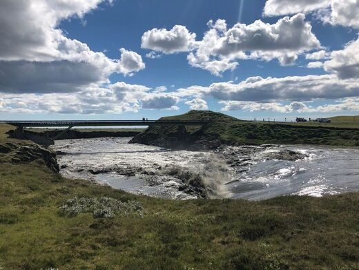
The river Skaftá in Southern Iceland has been seeing changes in recent days indicating a flood has begun.

Electrical conductivity in the river has increased steadily over the past two days, an indication that geothermal factors are involved. The water level has also risen in the past few hours, according to MBL. According to the Icelandic Meteorological Office, sulphuric smells have also been reported in the vicinity of Skaftá and Hverfisfljót.

Residents and passersby in the area are encouraged to remain diligent and apprise themselves of potential changing conditions in the area. Flooding over the riverbank and across nearby roads is possible in the next few days.


iceland flood map national park volcano
© Yandex
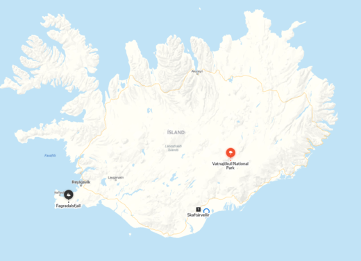
Map showing location of Vatnajökull National Park, Skaftárvellir, and Fagradalsfjall volcano that saw earthquake swarms in 2019 and began erupting in 2021

Additionally, the concentration of hydrogen sulphide from glacier runoff to the river is so high that it may damage the mucus membranes of the eyes and respiratory tract. Cracks are also able to quickly form around Vatnajökull at this time. Tourists are therefore encouraged to avoid this area as well as Skaftárjökull, Tungnárjökull and Síðujökull where running water may come to the surface.


Comment: Regarding activity at Vatnajökull, Wikipedia notes:
In more modern times, the volcanoes continue to erupt beneath the glaciers, resulting in many documented floods. One jökulhlaup in 1934 caused the release of 15 km3(3.6 cu mi) of water over the course of several days.[5] The volcanic lake Grímsvötn was the source of a large jökulhlaup in 1996.[6] There was also a considerable but short-lived eruption of the volcano under these lakes at the beginning of November 2004.[7]On 21 May 2011 a volcanic eruption started in Grímsvötn in Vatnajökull National Park at around 7 p.m.[7] The plume reached up to 17 kilometres (11 mi).[7]
Inflation at Askja:

Uplift detected at Askja volcano in Iceland, began end of July


Icelandic Met Office
Fri, 03 Sep 2021 22:00 UTC


Askja
© Wikipedia
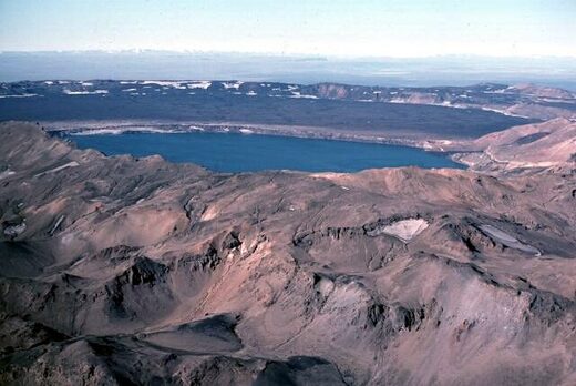
Askja is located in Iceland. Pictured here in 1984.
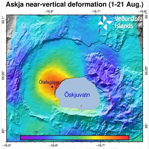
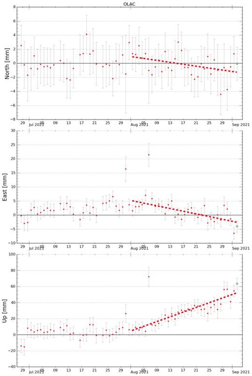
GPS observations and ground deformation maps derived from Sentinel-1 satellite data reveal that Askja volcano began inflating at the beginning of August 2021. The uplift signal is centered on the western edge of Öskjuvatn, close to Ólafsgígar, and corresponds to ~5 cm/month of vertical motion. Geodetic modelling (performed using both GPS and satellite data) indicates that the source of this inflation is located at a depth of approximately 3 km and corresponds to a volume change of approximately 0.001 km³/month.

The cause of such inflation is uncertain, but most likely it is due to the inflow of new magma. Askja volcano is seismically active and earthquakes are regularly measured in the area.


Askja

The image shows the near-vertical deformation in mm for the period 1-21 August. The InSAR image is obtained from two passages of Sentinel-1 satellite. The red color indicates uplift and the blue corresponds to subsidence (see the scale). The area experiencing the highest inflation is north-west Öskjuvatn. The black triangle indicates the location of the closest GPS station Ólafsgíga (OLAC).
The last eruption at Askja was in 1961. Regular geodetic measurements were done in 1970-1972 and showed a period of uplift, however no further measurements were acquired until 1983. Since then, a continued subsidence of a rate of 1 cm/year was detected until this current inflation phase started.

Active volcanoes in Iceland are often characterized by periods of inactivity, lasting years to decades, with intervals of enhanced seismicity, geothermal activity, and inflation. In most cases, magmatic intrusions do not culminate into an eruption. At this stage it is then very difficult to anticipate how the situation will evolve. The inflation is continuing at present (3. Sept 2021) and will be closely monitored by IMO which will distribute additional information in case of further changes.

More information about Askja volcano is available at icelandicvolcanos.is

Askja

Data from the GPS station OLAC (location shown in the InSAR image), for the North, East and Up components over the period 27 July - 2 September 2021. The station, which is located close to the center of the inflating area, shows that the uplift started between the end of July and beginning of August (mainly visible in the Up component) and it is still ongoing (2. Sept 2021). The dashed red line indicates the rise speed that is assessed to be ~5 cm /month.
 
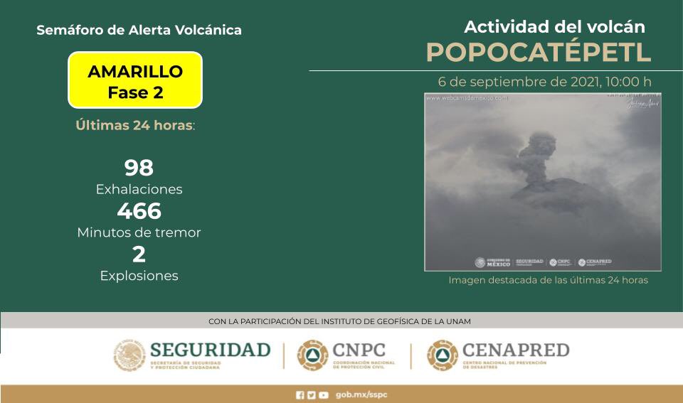
Protección Civil México@CNPC_MX
https://pbs.twimg.com/media/E-nJThZWYAUcB-N?format=jpg&name=medium

5:20 PM · Sep 6, 2021

[Suwanosejima Ash Fall Forecast (Breaking News)]
Within an hour, there is a rather large amount of ash fall in Toshima Village, and ash fall is expected to reach Toshima Village in Kagoshima Prefecture. Also, in the range from the crater to about 4 km southeast, small fountains may be swept away by the wind.

特務機関NERV@UN_NERV
7:17 PM · Sep 6, 2021
[Volcano Observation Report on Suwanosejima Eruption September 07, 2021 02:17] At around 02:07 on the 07th, there was an eruption at Suwanosejima (Mitake crater). The altitude of the eruption is 1500m above the crater, and the direction of the eruption is southeast.


Fagradalsfjall, Iceland
13 Sep 2021

Supposedly 5 new vents opened up at the Fagradalsfjall eruption site on Iceland today, after a recent longer break - making it now the biggest eruption in it's timeline.


••• Older images •••


Merapi, Indonesia
27 May 2021

Gunarto song captured on 27 May 2021 a meteor seemingly "plunging" into the crater of the Merapi volcano.

gunarto-song (photographer)-mount-merapi-2.jpeg


Fagradalsfjall, Iceland
26 Aug 2021

As the night returned to the arctic regions, photographer Marceau Gresse captured the Fagradalsfjall eruption together with Northern Lights on 26 Aug 2021

Marceau-Gresse-26-Aug-2021.jpg


Fukutoku-Oka-no-ba • Japan
27 Aug 2021


The shape of Niijima, a new island discovered at Fukutoku Okanoba, a submarine volcano in the Ogasawara Islands that has been erupting, has changed again, with the eastern part of the island partially submerged in the sea.

The Japan Coast Guard (JCG) yesterday released new photos of the new island, which was observed by aircraft at Fukutoku Okanoba, an underwater volcano about 50 kilometres south of Iwo Jima in the Ogasawara Islands.

On the 16th of this month, Niijima was shaped like a round "bracket" with a diameter of about one kilometer, but on the day before yesterday, the eastern part of the island was mostly submerged in the sea. The western part of the island was almost unchanged.

No eruption was observed during the observation, but at the crater between the two Niijima islands, a greyish material, probably volcanic ash, was gushing out over the sea surface and the color of the seawater turned brown over a wide area, extending westwards.

Professor Kenji Nogami of the Tokyo Institute of Technology, who was on board the aircraft, said: "Active volcanic activity is still continuing. The Niijima island to the west has not changed significantly and will probably remain as land for some time". (27th, 14:51)

Text below the YT video, DeepL translated

240713175_4289056807826149_4303489019914435058_n.jpg

240677451_4289056827826147_8899843256232127058_n.jpg
 

Trending content

Back
Top Bottom