Vulcano Cabeza, Cumbre Vieja Volcano
LaPalma, Spain
1 + 2 Oct 2021
From the german site
lapalma1.net from Manfred Betzwieser translated with DeepL.
Note:
Here at the Cassiopaean Forum, I inserted others photos, compared to Manfred's site, the latter which often shows low quality screen dumps. However I always try to keep the time frames equal, which means recent photos. If older photos are shown, I usually write that below the photo, or keep them outside of his text.
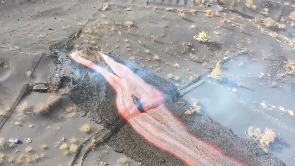
New Vent opened
Cabeza volcano rages on with another lava mouth
On the north-eastern side of Cabeza volcano, another lava mouth opened during the night. The leaking lava initially formed a lava lake. An extensive fumarole field was observed, which is now overflowing and forming a lava flow to the north.
However, it is expected to drift west towards the sea soon and join the old lava flow. Should this not be the case, it will again be very dangerous for inhabited areas. This was preceded in the evening by two powerful earthquakes of M3.4 and M3.5 at 18.50 and 20.30 hrs from a depth of 13 kilometres. Volcanologists expect further quakes, which could also exceed M4.
It is not unusual for an additional lava mouth to form in the immediate vicinity of the main eruption, which can disappear just as quickly.
Plume of gas and ash moves northwards
PEVOLCA is more concerned about the change in weather conditions. This morning, the drifting of the smoke column towards the north could be observed from the eastern side.
In Los Llanos, ash has already been falling for hours, as residents tell me. It remains to be seen how far north ash will fall, perhaps as far as Tijarafe. The measured height of the ash and gas column was 2500 m yesterday. The prevalence of atmospheric stability contrasts with the presence of a significant thermal inversion.
Today, according to AEMET (meteorological service) calculations, the gas column is expected to drop to about 700 metres as a warm and dry mass of African origin penetrates and pushes over it. The above configuration will move the ash and SO2 cloud from the eruption area to the north-northwest and mainly affect the western slope of La Palma. The high stability in the lower layers of the troposphere, together with the weak winds on the western slope, will present unfavourable meteorological conditions from an air quality perspective.
New island grows
The injection of lava into the Atlantic Ocean at Tazacorte has already created an island 40 metres high and 700 metres wide. The surface area is 16 ha.
There is already debate among historians as to whether it is an island, a delta or a fajana . Fajana means a plain at the foot of a cliff. And that is exactly what is formed on the cliff of Tazacorte, which could perfectly be called Fajana del Perdido - according to one of the opinions. I think there are more important things at the moment than worrying about naming things.
Timeline • 1 Oct 2021
11.30
The new lava flow that formed yesterday at the Cumbre Cabeza volcano is heading for the Callejón de la Gata industrial park in Los Llanos de Aridane, according to Canarias Radio. The lava appears to have crossed the LP-2 road and is not connecting with the main flow.
12.15
The emission of water vapour and gases in the area of contact of the lava with the seawater maintains an active cloud (maritime plume), which is monitored by scientists. Residents of the coastal towns of Tazacorte - San Borondón, Marina Alta, Marina Baja and La Condesa - remain confined, while Canary Islands Emergency Service 112 recommends the use of FFP2 masks outside the 2km exclusion zone and discourages vulnerable people from going outside.
13.00
The island of La Palma continues to grow. Now there are already around 30 hectares of new land.
14.00
The eruption of the Cabeza volcano is increasing day by day the damage caused since last 19 September, when the process began in the area of Cabeza de Vaca and has now affected 1,005 buildings, of which 870 are completely destroyed and 135 severely damaged, according to the latest data update from the Copernicus system. In addition to this damage, 30.2 kilometres of roads, paths and asphalt roads have been destroyed by the lava.
14.30
It is an inferno what the people in the Aridane Valley have to live through right now. The new lava flow is probably passing the main town of Los Llanos de Aridane at breakneck speed. Next on the finish line towards the sea is Tazacorte.
14.50
Statement from IGN - Eruptive activity on La Palma continues. Since the last statement, a total of 12 earthquakes have been located in the southern area of La Palma, close to the volcanic eruption in progress. As on the previous days, the hypocenters are located between 10 and 14 km deep in the same area where the reactivation began on 11 September.
Two of the earthquakes were felt by the population, the largest of which had a maximum intensity of III in the epicentral zone and corresponds to a magnitude 3.5 mbLg earthquake yesterday at 20:30 UTC. The mean amplitude of the volcanic quake remained stable during yesterday morning within a range of mean values for this eruption. From 18 UTC yesterday, it gradually began to increase until it reached values similar to those it had reached during the first two days of the eruption (19-20 September).
The island's network of permanent GNSS stations shows a return to deformation stability.
14.55
The beginning of the eruption has extended towards the north, where many houses have been destroyed, said the President of La Palma. The fact that this volcano has ejected more than 80 million cubic meters of magma, compared to 40 million from Teneguía in a third of the time, shows the aggressiveness and intensity with which it has worked in these thirteen days, he said.
16.00
There are even two new vents. These two new lava emission centres, which are about 15 metres apart, appeared at half past two in the morning and are located at a distance of 600 metres from the base of the cone in a northwesterly direction. The new flow originating from these centres is to the west, parallel to the flow that enters the sea from the north and reached the LP 212 road this morning. This was reported by the technical director of PEVOLCA, Miguel Ángel Morcuende.
16.10
A new ML3.6 quake at 3.13pm from 10km depth in Fuencaliente.
Cheerful slogans that do not correspond to the truth
16.20
"The problem is concentrated in the Aridane Valley, but the rest of the island is living a normal life with some ash problems, but in general life is normal and without overshoots," explained Morcuende from PEVOLCA.
Those who let such sayings go have no idea about the emotional life of the Palmeros. Almost everyone has relatives or friends who have been directly affected by the volcanic eruption. Many of the evacuees now live on the east side or in the north of the island. It is not just the lava flow that has destroyed hundreds of homes and the livelihoods of many families, but the family and social impact that a volcanic eruption of this magnitude has in an inhabited area. The whole of La Palma is affected.
Miguel Ángel Morcuende is not a Palmero, so he does not understand the situation. It makes me angry when the head of the crisis team, officially spreads such bullshit.
17.20
These are the lava masses that are currently falling out of the new opening towards the sea. Fast-flowing and very fluid lava that cannot be stopped.

18.20
New earthquake from 12 km depth at 17.53 with M3.4 in Fuencaliente. So with the strong lava ejection, it will continue during the night.
- - - - - - - - - - - - - -- - - - - - - - - - - - - -
2 October 2021
Poor air quality forces curfew
Air quality heavily polluted with sulphur dioxide and ash
Due to the deteriorating air quality, the curfew is extended to several areas of Los Llanos and El Paso. The volcanic cloud spun like a top yesterday
In addition to the four districts on the coast of Tazacorte San Borondón, Marina Alta, Marina Baja and La Condesa, areas of Los Llanos and El Paso have now been added. The risk zone is the area between the crossing of Camino Cruz Chica with the main road LP-2 further west to the intersection with Nicolás Brito Pais, further on this road to the ring road and through it to the Hoyas Hondas roundabout.
Likewise, the entire area that was affected by the August fire. Up to the El Paso football field, including the area west of LP-3 up to the Sombrero roundabout. Due to weather conditions, there are significant risks from elevated levels of sulphur dioxide and other toxic suspended solids. The curfew was ordered by PEVOLCA last night for an indefinite period.
Full steam ahead
The Cabeza volcano seems to be up to something. Gases and lava are pouring out of all the vents. At the moment, the plume seems to be pointing south. On Friday, ash even fell in the northernmost municipality of Santo Domingo de Garafia. No corner of the island is spared the effects of the volcano.
A look at last night's quakes shows the multitude and the strength. Everything from M2.1 to M3.0 was present. It all took place in the area of the magma chamber at a depth of 10 to 13 km. The shallow quake at only 1 km near El Paso was probably a relaxation quake.
So far, there have been none of the expected stronger quakes over ML4. However, it is only a matter of time before the conveyor channel is blocked and has to be cleaned free. I still have to get an up-to-date picture of the course of the lava channels towards the sea and will write something about it later. Actually, I had planned to get a direct impression on site.
Because of the sulphur fumes, the excursion has now been postponed and I don't want to get in the way of the rescue workers.
*end*
Other images I picked up
Apparently from what I understand is, that the winds during this time were calm, which lead to the formation of a plume with unusual looking rings, seen from a 3D kind of mindset... I have in rare images seen this phenomena with Etna on Sicily doing the same, when the winds are all calm.
__________________________________________________________________
Vulcano, Aeolian Islands
Sicily - Italy
1-2 Oct 2021
Oh, and I found a
recent photos of Vulcano, in the Aeolian Islands showing a higher degree of degassing. One observation: I have noticed during my trips to Vulcano, that
humidity also plays a roll in how much steam becomes visible at the rim of the Fossa Crater.
Photo by Meret Bertschinger, showing Vulcano before sunset on 1 Oct 2021
Photo by Gianluca Rando, who also wrote on Facebook:
All my sympathy to the Friends of Vulcano (Aeolian Islands). As you may have heard, a thick, visible tongue of smoke is currently rising from the crater of the volcano, which has been inactive for about 133 years. The activity of the archipelago is constantly monitored by the National Institute of Geophysics and Volcanology.
Tutta la mia solidarietá agli Amici di Vulcano (Isole Eolie). Come avrete appreso, attualmente una lingua di fumo ben densa e visibile fuoriesce dal cratere del vulcano, inattivo da circa 133 anni. A monitorare costantemente l'attività dell'arcipelago è l'Istituto Nazionale di Geofisica e Vulcanologia.
 www.zerohedge.com