Gaby said:
The thermometers have marked some 44 degrees under the sun in several regions of Spain. It reminds me of the heat wave back in 2003.
[...]
I prefer the cold!! :/
Indeed, 2003 was very intense in BC/Alberta Canada, too. That year, the fire indices became extreme by mid July moving into August. The fire weather index (FWI) for Drought Codes (DC) for instance was off the grid. Then, like in some places now, lightning strikes resulted in near 100% ignition.
Bluefyre said:
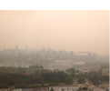
We're in the middle of a heatwave and looming drought here on the west coast of British Columbia with no rain in the foreseeable future. I've lived here for 9 years and never experienced anything like it. I've attached (hopefully) a picture of what Vancouver looked like yesterday. The winds have been blowing in reverse of usual, coming from the interior, Alberta and Saskatchewan bringing the smoke from the multiple fires, swinging around and coming in from the west. Very weird, and SO hot! It was 100F yesterday.
Not good for Vancouver. Much of that smoke, although shared, is from the NE Pemberton fire (> 5,000 ha), and it's still growing. However, five more fires in the coastal region (Cougar Creek, Dog Mountain, Elaho, Old Sechelt Mine, Tsulquate River) are adding to the mix. The island fires are very scary, imo, insofar as that fuel type, its age and the rugged ground make it daunting to engage. Winds in all of these cases, due to coastal and inland mountainous daytime heating complexes, carries other extreme factors.
As Redrock12 stated, Northern Saskatchewan is in a real tough situation with the current wind flow pattern, and indices that have it in tinderbox conditions. Without topographical breaks, and although there are many lakes in the North, crowning fires will carry fast and far. Those evacuations will be hard on people with much loss.
Unfortunately, there is still close to 2 months of prime fire weather until overnight recoveries (dew) starts to help; although mother nature ultimately decides the outcome.
Here are a couple of useful sites (Canada) - Interactive map of Canada - http://cwfis.cfs.nrcan.gc.ca/interactive-map?zoom=0&lon=416654&lat=1858768&month=7&day=7&year=2015 (you can play around with the data fields). And the current Lightning Map - (some US states, too.) http://weather.gc.ca/lightning/index_e.html


 -No, I was not embarrassed, but ther is no photos of I would like to show you my picture, in fact I was so red in the face from the sun, because my new job requires work outside, it is completely unbearable.
 ;) ;D :P :(....
 Pierre's articles came to mind. It was completely ridiculous distraction from important events like the Greek referendum. At least there was also a march in support for the Greeks as well. Police cars were following it around.