What's the weather where you are?

Stockholm, Sweden
Midsummer's Eve • 24 June 2022

It is fairytale weather over Stockholm (and most part of Sweden) with wonderful temperatures up to 28°C / 82.4°F. Nothing excessive, really, but abit unusual that we get to enjoy Midsummer's Eve with such lovely weather. Midsummer up here is usually known as being a often a rather unsteady, even chilly, big holiday, with afternoon showers and nothing to write home about.

Not so this year. The sky is very clear and deep blue... The weather earlier has been on the unsteady side, like summer which didn't want to take off - but that has changed only recently (and I see that on my flowers and plants, too). The outlook looks absolutely lovely, with similar temperatures (without excess heat).

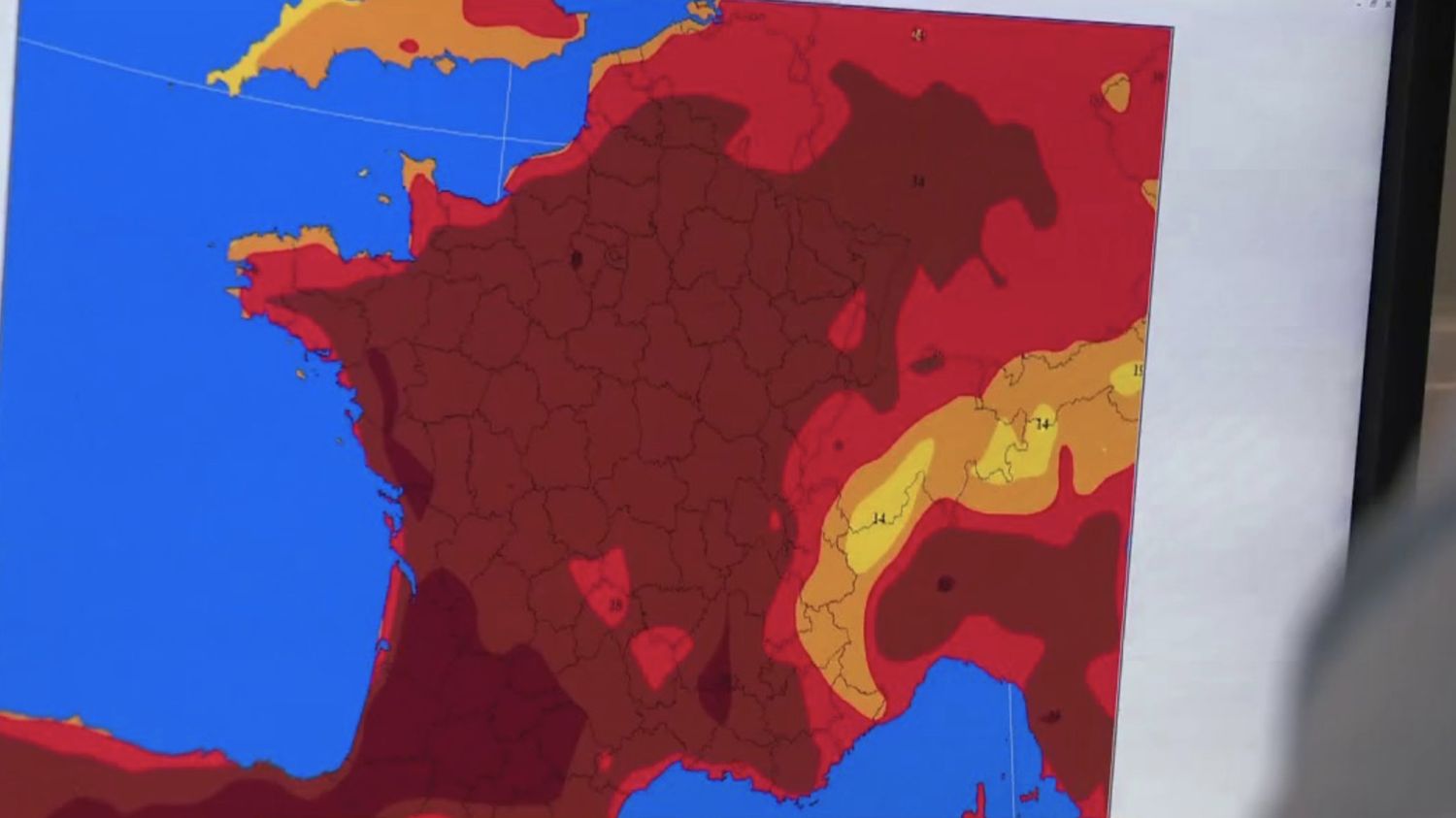
Here is a snapshot of the temperatures in Sweden right now. I manipulated :wizard: the temperature scale (see small image); from bloody red (25°C) back into more moderate colors, such as yellow and orange (which seems more realistic to me). After all - the average maximum temperatures in Stockholm this time of the year hover around 22-23°C.

Right now we got between 24-26°C in our region (albeit the inner city is now reporting 28°C at 14:00 from SMHI), yet that isn't exactly equivalent to "dark red", but just orange, I would say.

_-2022-06-24-at-14.05.22.jpg
 
Re: What's the weather where you are at?

Here in the center of Mexican Republic is cold. In the Toluca Valley we have a temperature of 14 Celsius and it is raining.

Tropical Storm "Celia" is located off the coasts of Michoacán and Guerrero in western Mexico and is causing moderate rains for the center and a lot of cloudiness.

It's very similar in the northern parts of Estado de México: Constant moderate rains (particularly at the night and in the morning), and temps around 12 to 16°C. This is an interesting contrast as we had a very dry and hot late Spring. The rain arrived at least a month late in these parts.
 
Stockholm, Sweden
27 June 2022

The warmth has increased during the past days, turning hot with widespread temperatures above 30°C (86°F) over large parts of Sweden - with at the most 33.1°C (91.5°F) in Maristad in Southern middle Sweden. Even Stockholm City got 2 hot days above 30°C, doday the hottest with 31.2°C (preliminary, but likely will have reached 32°C / 89.6°F). Here, where I live in the southern outer suburbs, it isn't quite as stuffed, more like 28-29°C (82.4 - 84.2°F)

It is of course always bit noteworthy when the temperatures rise above 30°C. in Sweden. But then again; it ain't unusual. There are however summers, in which temperatures do not even reach 30°C. in our capital.

In the west, especially over Norway, but also parts of West Sweden, numerous showers and thunderstorms are present. They glide up along the fringe of a high pressure area over Russia, which keeps the T-storms at bay in the west ;-D

2022-06-27-at-16.30.00.jpg 2022-06-27satellite.jpg

Again, I altered the original color scale made by RL.se which now is slightly reduced, not as fiercely red. Still - notice that there is barely any color separation visible between 22°C and 30°C - which I find annoying, because in reality - there is a pronounced difference in how it feels to the body !
 
Stockholm, Sweden
1 July 2022 • "Tropical" and "In the name of Thunder"

So, earlier we had 3 days with hot days in a row, between 31°C and 32°C. [87.8-89.6°F] - then it started to become more cloudy, humid and sticky, (with lower temperatures around 25°C [ 77°F ] which still felt very warm in combination with the humidity... kind of "tropical" or "South-European-like")

This morning, a huge cluster of T-storms, actually two, originated over Northern Poland, both on their way northwards - of which one swooped right up against Stockholm. As it was about to touch the southeast coast - there was plenty of lightning - yet it all fell apart in, once it crossed the city. (I only experienced one single major strike nearby as I was driving the subway along Bandhagen Station, in the southern suburbs - with lots of thunder. But that was all...)

Around 15 mm of rain fell in most areas. Interestingly - the temperatures were not affected by the rain at all ! They hovered unchanged around a minimum between 19 and 20°C (66.2-68°F), close to a tropical night.


Tonight - A repetition
It looks like there will be a repetition of this morning's event with a similar weather situation, after midnight at around 02:00. Another major T-storm complex is underway towards the Stockholm region; promising lightning and rain. It's gonna be a slippery subway for me tonight *LOL* Our modern trains are extremely sensitive to any kind of rain, snow, leafs, particles mixed with rain, making you slide easily. Sometimes a driver can't stop the train in time at the end of a station.


Image below

As i came out of the tunnel and crossed the bridge towards Slussen station in the city of Stockholm around 05:09, the sky was very dark (in fact darker than it was at the overcast sunrise) - and a lot of rain came down as I took the photo below.

2022-07-01-05-09-59.jpg
2022-07-01-04-14-58.jpg _-2022-07-01-at-20.22.41.jpg

the outline clouds of this T-Storm complex

In the satellite chart you can see a ring of feathery clouds spreading like a spiderweb outwards into most directions (which by the way, reminds me of how tropical storms look like in satellite images). At the ground around the same time (03:45), you didn't really see much of that visually, as most of it looked "gray-in-gray" with vague hues of blue.

But I happened to have a Leica M8 camera with me last night, which is "Infrared leaky"camera. So with an infrared filter, I was able to take infrared images of the southern sky, from which the T-Storm complex emerged. There, you can (partially) see how this anvil like frame was pulling up - like little ripples - announcing the approach of the very T-storm system.

A normal photo (in visible light) would have looked very boring, because it wouldn't have shown much structures or details in the sky.

2022-07-01-03-45-04.jpg
 
This is a report from Denmark about the observation of the Asperitas cloud type. The Wiki has;
Asperitas (formerly known as Undulatus asperatus) is a cloud formation first popularized and proposed as a type of cloud in 2009 by Gavin Pretor-Pinney of the Cloud Appreciation Society. Added to the International Cloud Atlas as a supplementary feature in March 2017, it is the first cloud formation added since cirrus intortus in 1951.[2] The name translates approximately as "roughness".[3]

The clouds are closely related to undulatus clouds.[3] Although they appear dark and storm-like, they almost always dissipate without a storm forming. The ominous-looking clouds have been particularly common in the Plains states of the United States, often during the morning or midday hours following convective thunderstorm activity.[4][3]
Below is the article except the video, which does not play besides being in Danish, the text is machine translated.
New spectacular cloud type seen rolling over Aalborg today
Jun 27 2022, 16:22
by Andreas Nyholm
The cloud with the Latin name asperitas was photographed over Aalborg on Monday morning.

A video of billowing clouds was recorded by Linda Fuchs in Aalborg on Monday morning.

The billowing clouds are called asperitas. It is a new type of cloud that has been named five years ago by the World Meteorological Organization (WMO).

The cloud was observed on Monday in front of an intense rainstorm that occurred in connection with a cold front.

The billowing cloud was seen in a westerly direction before the rain began in Aalborg.
Also in Løkken, the rolling clouds were seen on Monday morning.
1656705339097.png
Asperitas clouds seen from Løkken Monday morning Photo: Ole Kjær / Private photo
There are still discussions about how aperitas are formed, but the general theory about its emergence is that the clouds are often associated with an unstable atmosphere and are often followed by thunderstorms.

The theory fit very well with Monday's weather.

It was not only in North Jutland that the cloud was seen. Also at Lund near Horsens, TV 2 Vejret has got this picture.
1656705373748.png
Asperitas seen at Horsens on Monday morning. Photo: Helene Krejsager / Private photo

When asperitas was named in 2017, it was the first time in more than 60 years that WMO named a new cloud type.
 
Stockholm, Sweden
2 July 2022 • Repetition of Thunderstorms - part II

Yesterday's prognosis already suggested, that a second, similar weather situation would unfold during the night. And it did. But this time, the lightning did not die out over the city. 😍

So, this morning after midnight, a set of thunderstorm cells emerged out of nowhere, south of the city outside the coast. I saw some really, nice, bright, fat lightning strikes across half of the sky during the peak (02:20), some of which were really huge. What felt magic was, that it happened while the sky was still dark-ish. As I find it rare with night thunderstorms over Stockholm (partially due to that the night time up here is so short). For night thunderstorms you need humid warm conditions, or a powerful cold front coming in around midnight. Most lightning up here, happens in the afternoon, during daylight.

Around 00.55 I saw the first, very weak glimpses of lightning (in dull reddish colors due to haze and distance), towards the south of Stockholm, while still driving my metro train towards the depot. Then it all went pretty quick; a new set of thunderstorm cells rose right outside the southern coast of Stockholm, grew quickly and rolled into the city.

The peak was reached around 02.20 - and then ebbed out quickly. A second T-storm cluster to the east, went on for much longer (along the east coast of Stockholm county) - but you couldn't see nor hear anything.

Overall: Nothing major, nothing unusual, and with rainfalls rather small; between 0 mm and 6 mm across the city county. Just fun for a thunderstorm geek like me :wow: living in an area where those are too few and infrequent.

2022-07-02-01-00-45.jpg 2022-07-02-01-16-48-åska-thunderstorm.jpg

2022-07-02-01-07-44.jpg
2022-07-02-02-00-35-åska-thunderstorm-Gullmarsplan-GUP.jpg
2022-07-02-01-45-54-Åska-Thunderstorms-Gullmarsplan-GUP.jpg2022-07-02-01-45-55-Åska-Thunderstorms-Gullmarsplan-GUP.jpg

Reaching Gullmarsplan Plaza, at 02:02 - the lightning became much stronger now, with a little rain attached. The images are extracted from video clips. Since I was active on duty, I had not the luxury to make pretty images, just an iPhone at hand, while waiting for my next train to drive.

2022-07-02-02-24-00-Åska-Thunderstorms-Gullmarsplan-GUP.jpg2022-07-02-02-24-01-Åska-Thunderstorms-Gullmarsplan-GUP.jpg_-2022-07-02-at-19.11.58.jpg
Just two little blips really...
 
New record in the Netherlands: sunniest first half of the year ever measured.
Source (Dutch only): Eerste half jaar van 2022 was zonnigste ooit gemeten in Nederland

Less air pollution
First half of 2022 was sunniest ever measured in the Netherlands


3 hours 31 minutes ago Updated: 1 minute ago

The first six months of the year 2022 were the sunniest first half year ever measured in the Netherlands. With as many as 1162 hours of sunshine in De Bilt, it was a great month for sun lovers and solar panels.

The now counted 1162 hours of sunshine are far more than the long-term average of 909. With the 253 extra hours of sunshine, we got an extra June month of sunshine, so to speak.

In particular, starting in March, it was sun, sun and more sun what rang true. "That month completely smashed the weather records," says meteorologist Philippe Schambergen of Buienradar. "That was also an incredibly dry month with only 1.4 millimeters of rain in the entire month."

Super-sunny spring months

Still, perhaps not everyone will have noticed right away that we were fast on track to a sunshine record. That may just have something to do with the fact that in recent years we have begun to get used to super-sunny springs. Just think: the six sunniest first half years all fell in the 21st century. Five of those six even after 2010. The number of sunshine hours per month has been tracked since 1901.

The springs are therefore becoming sunnier at a rapid pace. Remarkably, this does not necessarily seem to be related to climate change. The latter is undeniably causing heat records, but heat is of course something else than sun.

The KNMI [Royal Dutch Meteorological Institute] recently calculated that the increasingly sunny spring still fits within a pattern of natural variations.

Cleaner skies

Moreover, there are other known factors that have a marked influence on the amount of sunshine, such as cleaner skies, for example. This was well illustrated in the spring of 2020, when corona meant there was hardly any traffic on the roads and in the air.

"But anyway, the air today is a lot cleaner than it used to be," says Schambergen. "That's not to say that there aren't other problems with air quality, like with CO2 for example, but in this area the world has really made some strides."

The remarkable thing is that the phenomenon of more and more sun occurs mainly in the first six months of the calendar. If you look at the amount of sunshine in the second half of the year, the same trend does not emerge. Then it is mainly years from the 20th century that dominate the top ten. There is no immediate explanation for this.

Translated with www.DeepL.com/Translator (free version)
 
Stockholm, Sweden
4 July 2022. 05:00

Yesterday, we registered still a summer day with 25.3°C (77.6°F) in the city core.

The temperatures during night time have dropped, especially in the suburbs, (earlier from very high 19°C / 66.2°F) now down to slightly below normal 12°C. (53.6°F) The morning sky is showing exceptionally clear air without a single cloud.

However, showers and rain are pulling up over Southern Sweden, and should arrive here soon. The outlook seem to be slightly unsteady and slightly cooler than normal, e.g. maximum around 18-20°C (64.4 - 68°F) - while the normal Max this time of the year lies around 22-23°C (71.6-73.4°F)

2022-07-04-04-05-13.jpg
Sunrise at our balcony, 4 July 2022 at 04:05
 
Stockholm, Sweden
8 July 2022

We seem to have entered a rather unsteady and slightly cooler weather compared to average in Stockholm - with an outlook of only moderate warmth (one day we may get 25°C / 77°F) but the rest of days can stay as low as 18°C (64.4°F). Albeit no rain was predicted for today, we got tiny shower cells popping up out of the blue 2 hours ago - without really moving... So, it has been raining on and off, after all.

However, no thunderstorms have developed this far, no drama in the skies other than the visual appearance. Temperature is now down at 17°C / 62.6°F, twenty minutes after I took the image.

I find the following effect fascinating (at times also confusing): What looks like a tiny cloud in a satellite chart, or a little blip on the radar - can (sometimes) mean much more dramatic weather is taking place at ground level - compared with just looking at charts alone.

2022-07-08-12-33-58.jpg

_-2022-07-08-at-12.41.27.jpg
 
The Palette of Sunrise Colors
Stockholm • 8-10 July 2022

The somewhat unsteady and slightly too cool July weather up here in Stockholm - does however provide a spectrum of interesting, at times really beautiful colors and cloud formations in the sky. I thought I share some of those impression with you, showing the past three early mornings. :flowers:


2022-07-08-03-30-48.jpg

2022-07-08-04-09-21.jpg

2022-07-09-04-15-36-at-Sunrise,-Snösätra.jpg

2022-07-09-04-16-01-at-Sunrise,-Snösätra.jpg

2022-07-09-04-17-15-at-Sunrise,-Snösätra.jpg

2022-07-10-03-55-08.jpg
 
Here in western Melbourne, FL, almost every day there are large storm clouds of which in the last month I have observed only a quarter of them end up in rain, just passing sideways in these huge clouds.
Although the temperature can reach up to 34 degrees Celsius, the temperature at night then drops between 8 and 9 degrees Celsius, reaching up to 24 degrees Celsius.
292285327_577381923788508_8653445005319796449_n.jpeg
291821999_1015152559193448_4566542590589520795_n.jpeg
 
As "elites" on the planet are trying to hold a tighter totalitarian grip over the people when weather have its feedback and it is not looking good.

Las week it was very hot in Macedonia. It was about 38C during the day on the sun. Over the nigh the temperature drop was evident and it was very pleasant and even chilly at the moments. I was writing about this earlier in some of my posts, but now this difference in temperature under the direct sun and in the shade are even more drastic.
Then on Saturday we had a huge rainstorm with strong winds. Floods and broken tree branches everywhere. From 38C the temperature dropped to only 12C in a matter of a few hours. It was like a middle of October or November not a middle of a summer.
The rain storms are usual during the summer in this region but they never brig such a temperature drops. They were just a short and strong summer showers.

For the first time some people filmed a small Waterspout in the biggest lake in the country. It is a first time ever for such a thing to happen here in Macedonia.

The same day few incidents with swimmers and small boats happened to a tourists from Macedonia that were on vacation in Greece coast.
Some sudden and unexpected sea storms and very powerful and totalu unusual and unexpected sea currents.

This morning it was sunny again, but very chilly in the morning. My point is that even it is a summer here, the air, the atmosphere is very cold. The heat under a direct sun is very unpleasant and there are very sudden and drastic temperature drops.

My Brother in Melbourne also told me that they have the coldest winter since he went to Australia 16 years ago. For the first time they have the heating on for 24 hours and at the same time the natural gas prices are breaking records. IN the winter they would usually turn on heating during the nights, but now it is very cold and people are not used to such a temperatures.
 
Selon plusieurs prévisionnistes, une vague de chaleur va s'installer pour au moins dix jours en France, à partir du lundi 11 juillet. Le Sud-Ouest et la vallée du Rhône seront les plus durement touchés.
Mais chez moi à Cagnes sur Mer (Côte d'Azur n France) c'est encore respirable :
30/34° l'après midi et 22/25 le matin pour la semaine prochaine

According to several forecasters, a heat wave is going to set in for at least ten days in France, starting on Monday July 11. The South-West and the Rhone valley will be the hardest hit.
But at home in Cagnes sur Mer (French Riviera) it is still breathable:
30/34° in the afternoon and 22/25° in the morning for the next week
 
Stockholm, Sweden
15 July 2022

2022-07-14-20-12-08.jpg

Chilly weather

has replaced our summer weather, with temperatures only reaching to 15-17°C (59-62.6°F) today (Normal Max is 23°C / 73.4°F) this time of the year. Despite numerous showers and clouds yesterday (see above photo) - but less are present today - and the weather is actually on the friendly side; with the sun often showing up. It is very windy; the trees make lots of sounds, similar to the feeling you get in the end of August / early September up here.


Weather Psychology (tricks)

Here below, i just want to show another example of what I call "Deceptive Weather Psychology" being used on people today - the subtle (or not so subtle) mind tricks which have become so popular, by using false, alarming red (or even brown) colors in temperatures (dependent in which country you live in).

I mean, 15°C in Stockholm in July, equals to 8°C below normal - yet, is illustrated with yellow-orange colors in the left "psycho chart". Which is nuts, really !

In the right chart, I shifted the color representation to what feels more realistic in terms of actual temperatures compared to normal average this time of the year.

_-2022-07-15-at-14.43.02.jpg
 
Back
Top Bottom