What's the weather where you are?

Hello All

We are currently having a weird Hot weather, 35 degrees is 5 degrees more than the normal in these days and in this place, we usually have for April a temperature of 30 °, sincerely this situation take my attention completely since it's not normal to feel this sensation of high temperature in this place.

The sensation of hot is high enough to feel down and the animals also
show very tired and down. 🥵🥵
 
After all the rain and snow this winter Yosemite is closing in preparation for flooding:


And up in Cloverdale, CA auroras appeared from a recent geo-magnetic storm:


“SLIDE 1 OF 4
The aurora borealis turns the night sky pinkish blue above Sonoma County, Sunday, April 23, 2023. The lights are of Palomino Lakes, right, Cloverdale, middle and Holland, left. A large geomagnetic storm buffeted the earth with spectacular colors as far south as Big Bear and Mojave in California. A 13 second exposure was made to capture the image. (Kent Porter / The Press Democrat)”
 
Hello All

We are currently having a weird Hot weather, 35 degrees is 5 degrees more than the normal in these days and in this place, we usually have for April a temperature of 30 °, sincerely this situation take my attention completely since it's not normal to feel this sensation of high temperature in this place.

The sensation of hot is high enough to feel down and the animals also
show very tired and down. 🥵🥵
Hello Zim - where are you located ?


Stockholm, Sweden
26 April 2023

Here the temperatures went down considerably. After that wonderful first springtime period, with temperatures up to 21°C, they don't exceed 10°C (often just hovering around 7°C) and on Saturday a MAX of only 5°C are predicted during the day.

23 April 2023
As the colder air pushed towards the Stockholm region during 23 April 2023, a fascinating contrast developed in our region: While we could still make it to 16°C, and the town of Uppsala reported 16°C, only 80 km away in Gävle, the temperatures didn't exceed 2°C. Slightly more to the north, it was then snowing most of the day.

Illustrated in this chart:

2023-04-23-at-16-27-00.jpg
 
Hello Zim - where are you located ?


Stockholm, Sweden
26 April 2023

Here the temperatures went down considerably. After that wonderful first springtime period, with temperatures up to 21°C, they don't exceed 10°C (often just hovering around 7°C) and on Saturday a MAX of only 5°C are predicted during the day.

23 April 2023
As the colder air pushed towards the Stockholm region during 23 April 2023, a fascinating contrast developed in our region: While we could still make it to 16°C, and the town of Uppsala reported 16°C, only 80 km away in Gävle, the temperatures didn't exceed 2°C. Slightly more to the north, it was then snowing most of the day.

Illustrated in this chart:

View attachment 73841
Hello Xpan

I'm in Costa Rica, usually the range of temperatures are between 24 to 30 max, but we have a week and a half with really high temperatures.

Yesterday I spoke with some people from the area and they were talking how this high temperatures are affecting them, how they feel, I said yesterday I felt down as I saw the animals too very down, so this people told me the same, it was curious for me, this sensation of heaviness in the Air.
 
A large downpour of rain and hail just passed through Brevard County, Florida, and the temperature plummeted to 18 C, with a feel of 15 C, it was a severe storm according to accuweather.com, it looked more like a summer thunderstorm.
It continues to rain and the forecast calls for more rain tonight. It's a bit concerning. Just keep an eye on the weather.
342528399_252869270452294_5541875930397022038_n.jpg
343639625_754774529632472_468826577523292658_n.jpg
343269240_983588386384766_3711273777033040871_n.jpg
 
Stockholm, Sweden
4 May 2023

2023-05-04-04-22-49.jpg

This morning around 04:23 a line of weak snow showers rolled in over Stockholm, and you could see flurries everywhere. This was just a short event, but kind of showed that weather is been playing on the colder side (frost is still a common thing in the suburbs, often down to -3 or -4°C, less if you live closer to the city) Even as I write this in the evening, we only have 2.5°C in the Stockholm southern suburbs, while Tullinge station already plunged below 0°C (again).

Tree leafs are a bit late / smaller in growth
I also noticed that nature is slightly on the late side. Or better said, the latest since at least 2011. The green in trees is small, and I noticed in older photos from previous years in May, that nature was more or less covered with fresh, light green leafs around this time, In the city of Stockholm I noticed a couple of cherry trees in blossom, but not here in the Southern suburbs - nothing - because the leafs have barely even come out yet.

'Global Warming' only takes place in the city cores. Outside of them. It is way colder, especially during night times.
 
Stockholm, Sweden
5 May 2023

Just a little (cold) addition. The temperatures in the far-out suburbs, like Stockholm-Tullinge, went down steeply to -6°C / 21.2°F this morning, but also at the border of the inner city in Stockholm, I saw frost on the outdoor subway platform (Gullmarsplan plaza). Now, the low temperature in Tullinge is no cold record, but certainly a very low value for this time of the year.

The cold record at this young-ish station (1955-2023) was set more recently in the morning of 9 May 2017 with -8.6°C / 16.5°F. Normal MIN this time of the year would be around +2°C.

2023-05-05-06-35-35.jpg
5 May 2023 • Frost in the southern suburbs of Stockholm (Rågsved)
 
#pluie #sécheresse Yesterday's disturbance was of a rare magnitude - it rained over 98% of metropolitan France with more than 10 mm in 24 hours over approximately 3/4 of France! Once again, the Mediterranean regions will not have had much (protected by the massifs). Map of Tuesday's rainfall accumulation (24h)

Nice rolling cloud of the occluded front around the low pressure which is shifting towards the east. Elsewhere, instability is already present in the southwest, and will strengthen during the day. #orages will break out in #Bretagne and Pays-de-La-Loire from midday.
 

Attachments

  • Fvrh_SKXgAAHHkt.jpg
    Fvrh_SKXgAAHHkt.jpg
    85 KB · Views: 3
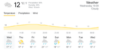
  • Screenshot 2023-05-10 at 10-45-12 current temp in france - Google Search.png
    Screenshot 2023-05-10 at 10-45-12 current temp in france - Google Search.png
    43.3 KB · Views: 3

What is normal month of May in France?

Tuesday, May 16, 2023 Guillaume Séchet Snip:
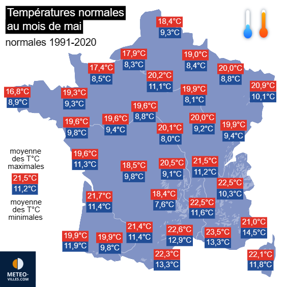
Seasonal normals in MayMay is indeed a month of spring and not of summer. The average minimum temperature in May is still below the 10°C mark on a good part of the stations in the northern half and in the center of France. Regarding maximum temperatures, reaching the heat threshold (25°C) is not the norm during this month, contrary to what the last months of May might have led us to think. The normal is 18.4°C in Lille, around 20°C in Paris & Metz, 21.5°C in Lyon and 21.7°C in Bordeaux. The Mediterranean resorts have averages between 21°C in Nice and 23.5°C in Marseille. Note that these normals were calculated on the basis of readings between 1991 and 2020.
mai-temperatures-normales.png

Normal minimum and maximum temperatures in May - Météo Villes

With rising temperatures, instability also tends to increase during the month of May, which is traditionally the month that kicks off the stormy season. Therefore, the average rainfall totals in May are relatively high. The normal is 62 mm in Lille, 69 mm in Paris, 71 mm in Bordeaux, 77 mm in Strasbourg or 81 mm in Lyon. It reaches 116 mm in Biarritz but does not exceed 38 mm in Marseille and 40 mm in Nice. There are on average 9 to 12 days of rain (at least 1 mm) in May, except in the Mediterranean where the figures are 4 to 6 days. Note that in some areas of the country, the wettest month of May of the year. This is particularly the case in Paris, Toulouse or Strasbourg.

Normals for the number of hours of sunshine in May - Weather forecast

May 2022: a remarkably hot and dry month

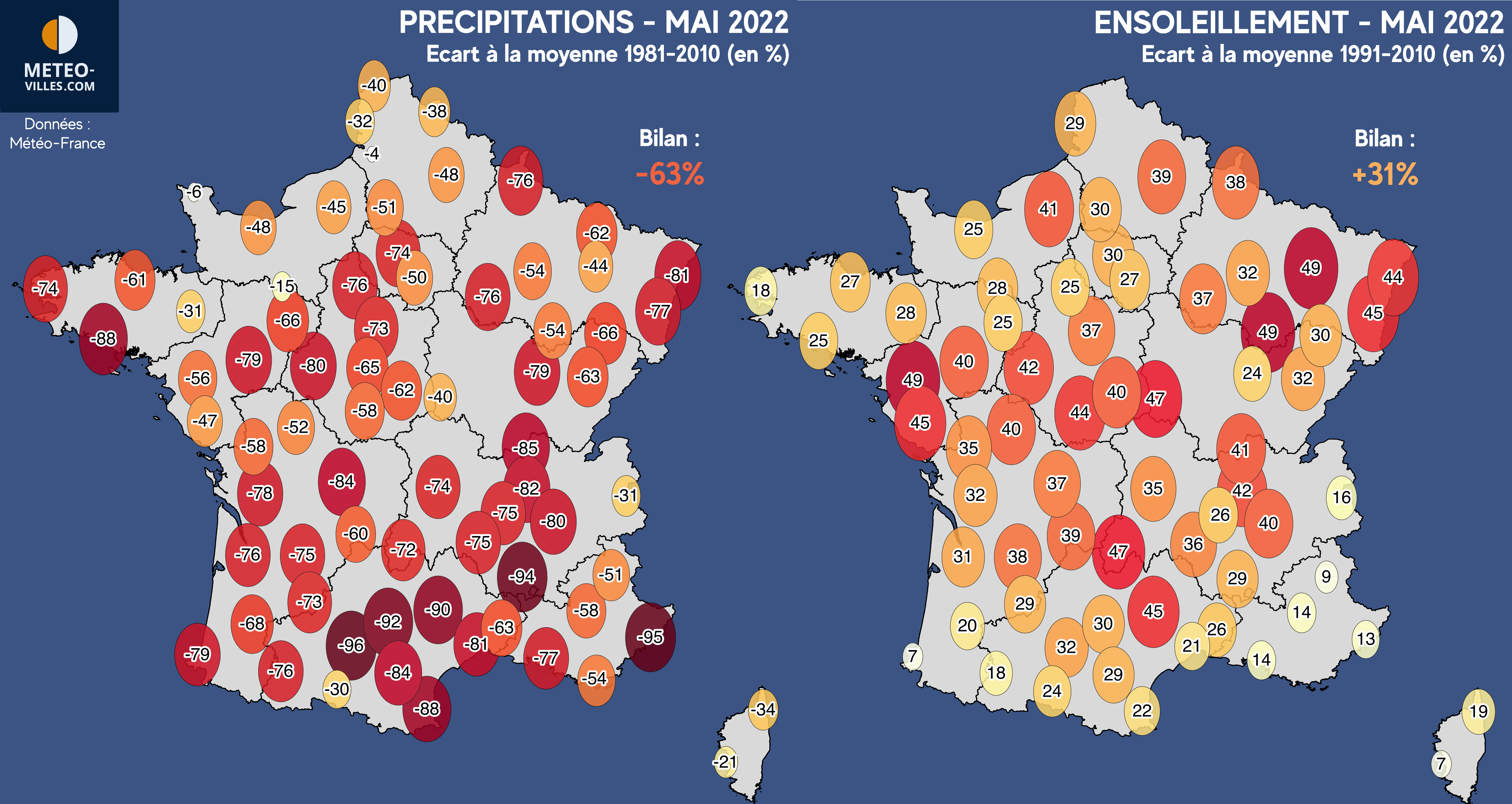
The problem being that we experienced an exceptional month of May last year and that the temptation to compare it with the current month of May is great but would be misplaced. Indeed, May 2022 had been remarkably warm with a thermal anomaly of +2.7°C in France! It was also particularly dry with a rainfall deficit of 63%! To top it all off, the sunshine had been very high with an excess of 31%! We had experienced a real month of summer before our time. We must therefore not make the mistake of comparing the current situation to May 2022, which was a real climatic UFO.


Screenshot 2023-05-17 at 08-07-32 Extreme Temperatures Around The World on Twitter.png


Sometimes #froid this morning of May 2023, 17, especially in the countryside 0.2°C in Turquestein-Blancrupt (57) 0.5°C in Nitting (57) & Argentat (19) 0.6°C in Chaillac (36) 0.7°C in Monteils (12) 0.9°C in Montluçon (03) 1.1°C in Fargues-sur-Ourbise (47) 1.3°C in Epinal (88)


Wednesday 17, 2023 08:41
Screenshot 2023-05-17 at 08-02-43 Pic du midi L'incontournable des Pyrénées.png


M9.6 Flare Could Spell Aurora In The Coming Week! - Massive Fires In Canada Smokes Out The US
 
Stockholm, Sweden
17 May 2023

It is late afternoon, and the temperatures have dropped to a mere 6°C here (which is 11°C below normal ø max this time of the year). A residual low affects the east part of middle Sweden, covering the city with rain and dense clouds. The irony is, that this morning on my way home from work, at 06.15 - the temperature was 12°C (marking the peak, so to say).

Recently, I got myself a (wireless) rain meter for the first time ever - which appears to work accurately - showing that 9.2 mm rain had fallen since midnight. That is pretty in the range of what other surrounding (private stations) reported.

2023-05-16-17-55-01.jpg

Magic in the air
I had one of those magic moments this morning: Because 12°C before sunrise, felt very mild in comparison to most mornings this far in May 2023 - feeling more relaxed compared to other nights. (I've been walking around with winter flavored clothes, double pants, until recently since i mainly work night time). Several stations reported night/day time differences up to 20°C; frosty 0°C before sunrise, and 20°C during afternoon.

So, this morning the air was filled with flower scents embedded in a moist but fresh feeling, like the imminent promise of rain. (Which came just a half hour later). Everywhere i looked - it was all green and nothing spared - almost like summer. 10 days ago, it looked more like "winter" with largely no green trees yet. (greening in bushes had started, yes, and flowers sprouted lively into bloom - but not the trees) The grows in leafs have been delayed by approx. 2.5 - 3 weeks this time (according to my own observations) making it the latest date I have ever witnessed since at least 2011 when i moved into this area.

Diving under a Roof of Greens
Now, within the past week, nature had exploded, accelerating its growth considerably. There i stood with the feeling of being in truly magical place... When you exit the Rågsved subway station, walking towards Snösätra along the park, the trees are so large, like a shielding roof of green high above and all around. This gives that walkway a very special feeling "as if diving into lush green cavern". Greens, so bright and light, only springtime can give birth to such. Some leafs were larger than my hand...

I think the magic got extra special this time, because the transition was sudden; going from thin and pokey - to large, lush and omnipresent.

Summarization
We had many nights of deep frost (in the outer suburbs) all the way down to -6.4°C during the first week of May, and brief snowfall on the 4th of May and meager daytime temperatures. Tullinge station reported frost most mornings until recently. While in the past week, summer like weather prevailed with lots of sunshine (15-16 hours per day)... In the city of Stockholm the temperature peaked with 24.8°C on 14 May 2023, only three days ago.

Now, it is only 6°C. 🥶
Oh, but wait a minute - the clouds have lifted ...


2023-05-17-at-18.16.57.png
 
Mother Nature unleashed heavy rain, lightning, and thunder, with minor flooding along the side roads.

The lightning and thunder were of moderately long duration as thunder claps seemed to roll pretty long and sounded like a war in the Heavens.

This map shows the rainfall accumulations predicted by the European model until June 2, 2023. With a powerful anticyclone over the British Isles, permanently dry weather sets in over the northern half. To the south, a few thunderstorms are expected.
(via http://meteologix.com )

Q: (L) Will there be atomic war?
A: No.
Q: (L) Will there be a war in the sky with the aliens?[10]
A: Yes.
Q: (L) Will it be between Orions and the Federation?

A: Yes.
Q: (L) Will it be visible on earth?
A: Oh, yes.
Q: (L) When will this be?
A: It has already started. Will intensify steadily.
Q: (L) Why are we not aware that it has already started?
A: Disguised at this point as weather. Fighting part still in other dimension. Will go to this one within 18 years. Anytime within this period. Not determinable exactly when. Could be tomorrow or 18 years.
Q: (L) 18 years from now is 2012. Is there some special significance to that time?

A: By then.
1684857572313.png

Strong thunderstorms in progress over the entire Piedmont between Ariège and Béarn they should approach Tarbes and Pau in an uncommon east-west flow @ma .swisskings

Stormy again this afternoon caution at altitude

Screenshot 2023-05-23 at 18-20-47 pyrenees weather - Google Search.png
This condition will repeat on Wednesday thru Tuesday of next week. 😬

This Wednesday will be very bright in the north and west. Stormy towards the southern reliefs. https://meteo-express.co /previsions/pre
 

Attachments

  • Screenshot 2023-05-23 at 18-26-35 Windy as forecasted.png
    Screenshot 2023-05-23 at 18-26-35 Windy as forecasted.png
    1.8 MB · Views: 0
Last edited:
It has been very rainy since last month, temperatures fluctuate between 30- 24 C, in Melbourne, Florida, I have been living in Florida for just one year and I am very impressed by its cloud formations, a couple of days ago there was a peculiar formation, although I don't have a panoramic image, I capture these details, a small part of the sky was still clear in a deep blue and the part where the storm was concentrated had these rounded folds, it looked like a part of the sky was pulled and stretched in a specific way.
348890963_1958694967798264_21968321316120878_n.jpg
346148771_634661574845232_6963040106958096607_n.jpg
 
It has been very rainy since last month, temperatures fluctuate between 30- 24 C, in Melbourne, Florida, I have been living in Florida for just one year and I am very impressed by its cloud formations, a couple of days ago there was a peculiar formation, although I don't have a panoramic image, I capture these details, a small part of the sky was still clear in a deep blue and the part where the storm was concentrated had these rounded folds, it looked like a part of the sky was pulled and stretched in a specific way.
View attachment 74980
View attachment 74981

How funny...

I got a Déjà vu feeling when you looked at your photos @jess !

We had almost exactly the same clouds over Stockholm this morning - which developed very sudden out of nowhere from uniform looking clouds earlier (The whole effect of mammatus clouds only lasted about 20 minutes). Apparently, it marked the tail end of a cold front passing over the city (while it was very mild in the air, 16°C). I sat outside the train depot smoking a cigarette with just a shirt on... enjoying the feeling.

The front released only a few single drops of rain, nothing else. Acting more like "Drama queen" clouds, looking ominous - yet without any action what so ever. (Normally, they indicate that strong rainfall is imminent, often together with thunderstorms) But there were no rain echoes registered, no thunderstorms, nothing. During the night, Stockholm remained still in a small warm air bubble with much higher temperatures compared to the rest of Sweden, before it all got pushed away to the east later in the morning).


2023-05-25-03-31-53.jpg

2023-05-25-03-34-48.jpg

2023-05-25-03-48-31.jpg

I had sent temperature & satellite charts to my husband, in order to make "boring" a bit more fun. I love to write about weather, but the feeling may not always be shared with my partners, other than when I do it in very small portions now and then :-P

The charts illustrate the passage of a cold front, as well the "warm air bubble" residing over East Middle Sweden at the moment when i took the photos of the mammatus clouds.


_-2023-05-25-at-21.23.44.jpg _-2023-05-25-at-21.23.35.jpg
 
South East USA - Charleston SC here reporting in - We're on the same latitude as northern Africa. This May has been cool and cloudy with some rain. May of 2021 and 2022 warmed up about half way through the month. But it's the end of May and it's about 60 F outside and windy. I've lived here for 30+ years - it's never been this cold this late in May.
 
Back
Top Bottom