You are using an out of date browser. It may not display this or other websites correctly.
You should upgrade or use an alternative browser.
You should upgrade or use an alternative browser.
What's the weather where you are?
- Thread starter Maia
- Start date
Insane weather activity for June 1, 2023 
This Friday will be sunny in the north and heavy in the south (locally strong thunderstorms). ➡ https://meteo-express.com/forecasts/pre
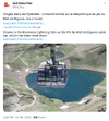
⛈ A storm is pouring intense rain on Grenoble accompanied by strong electrical activity! Images from Poisat. (© Remy Lienhard)
0 degrees at 2800m this morning of June 1st and 1st snow of the summer weather at high altitude . Last year, exceptionally, there were no occurrences between 1/06 and 1/09
  @picdumidi
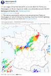
#hail falls have been recurrent for 15 days in the south. They are small in size, in the absence of atmospheric dynamism, but can cause agricultural damage in particular:KERAUNOS - Observatoire Français des Tornades et des Orages Violents - Prévision, suivi et étude des orages en France trend will continue for at least another week.
Many more storms in Provence, in Gard and Lozère. They gradually become rarer from the east. Return to calm over Corsica and the Eastern Pyrenees with clearings that widen.
This Friday will be sunny in the north and heavy in the south (locally strong thunderstorms). ➡ https://meteo-express.com/forecasts/pre
⛈ A storm is pouring intense rain on Grenoble accompanied by strong electrical activity! Images from Poisat. (© Remy Lienhard)
0 degrees at 2800m this morning of June 1st and 1st snow of the summer weather at high altitude
. Last year, exceptionally, there were no occurrences between 1/06 and 1/09 @picdumidi#hail falls have been recurrent for 15 days in the south. They are small in size, in the absence of atmospheric dynamism, but can cause agricultural damage in particular:KERAUNOS - Observatoire Français des Tornades et des Orages Violents - Prévision, suivi et étude des orages en France trend will continue for at least another week.
Many more storms in Provence, in Gard and Lozère. They gradually become rarer from the east. Return to calm over Corsica and the Eastern Pyrenees with clearings that widen.
Attachments

XPan
The Living Force
Stockholm, Sweden
3-4 June 2023
It was only yesterday morning, when the last of several of cold mornings (+ wind) dwelled in the outer Stockholm region, me yearning for gloves... in June (!) while at the same time watching some passengers at Gullmarsplan station, appearing in shorts. Brrr.
 Frosty !
Also; it was only yesterday morning, when frost was still registered in Southern Sweden, down to -2.7°C in Hagshult which became the coldest place in Sweden. In the much wider region outside of Stockholm: Film got (-0.0°C), Eskilstuna (-0.3°C) and Kerstingbo (-0.6°). Further away, Åmot got -1.6°C.
Finland registered frost in many places generally down to -3°C. On top, the country got an all time national cold record for June; in the morning of 1 June 2023, a staggering -7.7°C were registered at Kilpisjärvi Saana, albeit I need to add that this was set at an 1007 meter high located station. Further; frost was noted in Estonia, Northwest Poland, outside of Saint Petersburg; both north and south of it, and in a tiny area in east Scotland.
 Warm daytime
On the same day, temperatures in Stockholm then rose to a very pleasant 19-22°C. (but today only 17°)
Later, early evening, clouds started to roll in, originating from a weak cold front, but it preserved the lush summer warmth late into the night. Suddenly, the evening was 9-10°C warmer (around 17°C), compared to the previous evening...which was only 7°C. So, when i left home for work - it had that special feeling of wandering into an alluring, summer's eve. The kind, when you walk with a light feel through streets. Or perhaps... my hormones played me ?!


The coldfront
didn't make much buzz; a few drops over the southern suburbs, while up to 3 mm rain north of the city. Yet, those raindrops were enough to make the breaking action of the "modern" Stockholm subway trains become extremely slippery. That was 'fun' (read: me causing delays) and through the radio, they were asking me, what I was up to...
Close to record • Sunshine in May
Speaking of clouds and such: The Sunshine hours during the month of May here in Stockholm, have been though the roof. Albeit i don't have exact record statistics, but know enough that the total must be among the highest ever measured for May. You can see that in the following two illustrations below.
Around 12 hours in average - every day. That is truly remarkable. I believe the all time high record is 12.6 hours, so we were really close.


Temperatures in May 2023
Were a mixed bag in Stockholm and wider region. The start in the first 8 days was bizarre cold (at night) And even in the end of May, Tullinge station showed how it repeatedly fell back close to frost. Add some wind to it, and it feels like wanting to wear gloves again.
We got two short, wonderfully warm summer periods. (The drawback with my job is, that I often "miss" the warm days, because I work at night, and sleep during the day). This has the consequence of giving me a somewhat altered 'weather feeling in hindsight'. So, i never felt it was "that warm really", because in my reality, i faced the chilly nights, not so much the summery warm days.
Anyway - those two warm periods equalized the dominating cold statistics from the beginning of May, turning the whole month into a nearly normal average (about 0.5 - 1.0°C warmer than normal). By showing rural MIN temperatures however, you can spot that something wasn't always that 'normal'.
Like a silent reminder, that when you live in the north (Sweden), it still can get really cold in May - except in the artificially warm city core where all the woke Greens live; the only place where "global warming ™ " goes rampant.

3-4 June 2023
It was only yesterday morning, when the last of several of cold mornings (+ wind) dwelled in the outer Stockholm region, me yearning for gloves... in June (!) while at the same time watching some passengers at Gullmarsplan station, appearing in shorts. Brrr.
Frosty ! Also; it was only yesterday morning, when frost was still registered in Southern Sweden, down to -2.7°C in Hagshult which became the coldest place in Sweden. In the much wider region outside of Stockholm: Film got (-0.0°C), Eskilstuna (-0.3°C) and Kerstingbo (-0.6°). Further away, Åmot got -1.6°C.
Finland registered frost in many places generally down to -3°C. On top, the country got an all time national cold record for June; in the morning of 1 June 2023, a staggering -7.7°C were registered at Kilpisjärvi Saana, albeit I need to add that this was set at an 1007 meter high located station. Further; frost was noted in Estonia, Northwest Poland, outside of Saint Petersburg; both north and south of it, and in a tiny area in east Scotland.
Warm daytimeOn the same day, temperatures in Stockholm then rose to a very pleasant 19-22°C. (but today only 17°)
Later, early evening, clouds started to roll in, originating from a weak cold front, but it preserved the lush summer warmth late into the night. Suddenly, the evening was 9-10°C warmer (around 17°C), compared to the previous evening...which was only 7°C. So, when i left home for work - it had that special feeling of wandering into an alluring, summer's eve. The kind, when you walk with a light feel through streets. Or perhaps... my hormones played me ?!
The coldfront
didn't make much buzz; a few drops over the southern suburbs, while up to 3 mm rain north of the city. Yet, those raindrops were enough to make the breaking action of the "modern" Stockholm subway trains become extremely slippery. That was 'fun' (read: me causing delays) and through the radio, they were asking me, what I was up to...
Close to record • Sunshine in May
Speaking of clouds and such: The Sunshine hours during the month of May here in Stockholm, have been though the roof. Albeit i don't have exact record statistics, but know enough that the total must be among the highest ever measured for May. You can see that in the following two illustrations below.
Around 12 hours in average - every day. That is truly remarkable. I believe the all time high record is 12.6 hours, so we were really close.
Temperatures in May 2023
Were a mixed bag in Stockholm and wider region. The start in the first 8 days was bizarre cold (at night) And even in the end of May, Tullinge station showed how it repeatedly fell back close to frost. Add some wind to it, and it feels like wanting to wear gloves again.
We got two short, wonderfully warm summer periods. (The drawback with my job is, that I often "miss" the warm days, because I work at night, and sleep during the day). This has the consequence of giving me a somewhat altered 'weather feeling in hindsight'. So, i never felt it was "that warm really", because in my reality, i faced the chilly nights, not so much the summery warm days.
Anyway - those two warm periods equalized the dominating cold statistics from the beginning of May, turning the whole month into a nearly normal average (about 0.5 - 1.0°C warmer than normal). By showing rural MIN temperatures however, you can spot that something wasn't always that 'normal'.
Like a silent reminder, that when you live in the north (Sweden), it still can get really cold in May - except in the artificially warm city core where all the woke Greens live; the only place where "global warming ™ " goes rampant.

XPan
The Living Force
Stockholm, Sweden
8 June 2023

We have a sky
covered with diffuse, gently undulating thin clouds (looking kind of funny). I would say it is chilly with only 15.7°C / 60.2°F in the afternoon. The City itself, made it to almost 20°C earlier during the day, but Stockholm-Arlanda Airport, about 43 km further to the north, barely reached 16°C / 60.6°F at Max. (Normal Max this time of the year lies around 20-21°C / 68-70°F).
I think what happened during the past several days was, that 'pseudo' cold fronts passed the Stockholm Region, mostly without or barely any clouds, bringing colder air - while the South always remained under the influence of warm air.
There, it was up to 28°C / 82.4°F. warm today (Målilla)
It's been like this for several days, very warm in the south. Chilly in the middle, and plain cold in the north. There - in the extreme north of Sweden, it even has been snowing - while other parts of Northern Sweden have been way below normal temperatures in these first 8 days of June 2023.

PS: I altered the temperature color scale. Originally 16°C was shown with "orange", while in reality that is quite a bit below normal temperatures this time of the year.
8 June 2023
We have a sky
covered with diffuse, gently undulating thin clouds (looking kind of funny). I would say it is chilly with only 15.7°C / 60.2°F in the afternoon. The City itself, made it to almost 20°C earlier during the day, but Stockholm-Arlanda Airport, about 43 km further to the north, barely reached 16°C / 60.6°F at Max. (Normal Max this time of the year lies around 20-21°C / 68-70°F).
I think what happened during the past several days was, that 'pseudo' cold fronts passed the Stockholm Region, mostly without or barely any clouds, bringing colder air - while the South always remained under the influence of warm air.
There, it was up to 28°C / 82.4°F. warm today (Målilla)
It's been like this for several days, very warm in the south. Chilly in the middle, and plain cold in the north. There - in the extreme north of Sweden, it even has been snowing - while other parts of Northern Sweden have been way below normal temperatures in these first 8 days of June 2023.
PS: I altered the temperature color scale. Originally 16°C was shown with "orange", while in reality that is quite a bit below normal temperatures this time of the year.
XPan
The Living Force
UNUSAL COLD suburbs | Stockholm, Sweden
early morning of 9 June 2023
I find this quite peculiar... as all of the sudden, despite that we have short lasting nights - yet the temperatures in the outer suburbs are plunging down to almost frost. I really had to dig in deep in order to verify that this is real - and it seem to be. One private station from the WOW network, with a reliability value of 4 out of 5 points, reports only + 0.4°C (32.7°F). Others that are even closer to me, also report low values: 1°C.
At my station here in Snösätra-Rågsved, the air measures 9°C, and the ground 10 meter below around 7°C (We live on a little hill of 60 meter). On my way from the depot however, which lies much lower, i felt the chill in my hands... but not so much at my balcony.
Official station Tullinge, 7 km from my place in the southern area of Stockholm suburbs, reports +0.9°C (33.6°F) - but also plenty of other stations show low temperatures.
Even more strange is that a station called Adelsö, an island in the middle of the large Mälaren lake, just west of us, plunged down to +2.9°C (37.2°F) - yet the much warmer water (around 12-13°) doesn't seem to affect the island... Between 23:00 and 00:00 the temperature simply plunged down from 10.5°C to +3.5°C. I find that odd for being 9th of June. I also find it odd, because the airmass residing over our area isn't that cold really... the 850 hPa level at 1.5 km indicates +4°C. Chilly, but neither that cold nor unusual in anyway.
Then we got Marihamn Airport, located on the Åland Islands, which lies in the Baltic sea between Sweden and Finland - reporting only 1°C (33.8°F) - via an app i have, which shows me all airport temperatures around the world (The winds over Åland seem to come from the north - e.g. from the inland of the island - which could partially explain the lower temperatures... But at the same time, these islands are surrounded by much "warmer" waters: +11.3°C (52.3°F)
So strange... especially this time of the year.
I am a bit puzzled by this.
XPan
The Living Force
More frost temperatures
Stockholm, Sweden 10 June 2023

Kind of "funny"; the weather we have here in Stockholm and it's wider surroundings. Very summer like during the day. But kind of cold at night (except in the inner city). Yesterday morning, the final temperature in Stockholm-Tullinge was determined to -0.7°C. This morning it went down anew: to -1.2°C / 29.8°F. I find that remarkable, because we are almost into mid June now.
Morning of 10 June 2023
• Stockholm-Tullinge -1.2°C
• (Uppland) Film -1.0
• (Gävle Area) Åmot -0.7°C
• Stockholm Arlanda Airport -0.7°C
• Uppsala airport -0.6°C.
• Adelsö +0.9°C.
14 hours of sunshine. Every day.
During the day it is very sunny (crazy sunny!) - as it has been like every day for many weeks. We are up at a daily average of 13 hours per day in the past 30 days. And a whopping 14 hours hours day during the first 10 June days ! That is extreme high, possibly close to record levels.
When you are in the sun, it feels truly like summer - do doubt. However, there is a chill in the air (and has been), because the temperatures stayed below 20°C, albeit they are increasing now very slowing each day.
No rain has fallen since 16 May 2023 - and no rain is expected until 20 June !
Occurrences of frost nights in June
in the distant suburbs of Stockholm

I spend half day yesterday, another half today, trying to analyze the occurrence of frost nights in June, in the outer suburbs of Stockholm, in this case the station Tullinge, whose observations go back to 1955. I plucked out the days between 6th and 15th, in order to see the span width of minimum temperatures.
This is how it looks below: The lowest record for June since 1955, is -3.6°C (all of June's nights)
This morning's -1.2°C is not an unique event - but at the same time, not really common either. Last time it happened was June 2009 -1.2°C. To find a lower value, I have to go back to June 1984, with -1.5°C.
(Note: no data in existence between 1985-95, + year 2004)
Latest date for frost ever to have occurred at Tullinge station during start of summer season, was 22 June 1975 with -0.1°C.

How much warmer is the City Core of Stockholm ?
compared with the country side (Tullinge station) at night
Well, The city core is indeed a lot warmer. The graph below shows how much warmer the Minimum temperatures has been in Stockholm City compared to Tullinge station this far in year 2023. In total: 3.7°C warmer MIN. Similar last year 2022, with 3.55°C warmer MIN temperatures.
No doubt, the urban heating in city cores is very real. Or should I say "Global Warming" effect ? Tullinge is almost never warmer than Stockholm City.
A thought:
I sometimes think i see (but i have not fully tested this claim yet), a tendency of cooling has started to become visible. (But I always have to keep in mind "wishful thinking bias" affecting my views. Or let me rephrase it; it is in the outer outskirts any tendencies / trends become clearer visible. In the city's inner core however - those are not visible - because "Global warming" is kept alive in numbers due to the city's large island heating effect.

What about the MAXIMUM temperatures ?
How much higher are those in Stockholm City, compared with the far distant suburbs such as in this case, Tullinge ? Not much. Only 0.6°C warmer in average in the city so far this year 2023.
Tullinge MAX temperatures are mostly cooler than in Stockholm city.

Stockholm, Sweden 10 June 2023
Kind of "funny"; the weather we have here in Stockholm and it's wider surroundings. Very summer like during the day. But kind of cold at night (except in the inner city). Yesterday morning, the final temperature in Stockholm-Tullinge was determined to -0.7°C. This morning it went down anew: to -1.2°C / 29.8°F. I find that remarkable, because we are almost into mid June now.
Morning of 10 June 2023
• Stockholm-Tullinge -1.2°C
• (Uppland) Film -1.0
• (Gävle Area) Åmot -0.7°C
• Stockholm Arlanda Airport -0.7°C
• Uppsala airport -0.6°C.
• Adelsö +0.9°C.
14 hours of sunshine. Every day.
During the day it is very sunny (crazy sunny!) - as it has been like every day for many weeks. We are up at a daily average of 13 hours per day in the past 30 days. And a whopping 14 hours hours day during the first 10 June days ! That is extreme high, possibly close to record levels.
When you are in the sun, it feels truly like summer - do doubt. However, there is a chill in the air (and has been), because the temperatures stayed below 20°C, albeit they are increasing now very slowing each day.
No rain has fallen since 16 May 2023 - and no rain is expected until 20 June !
Occurrences of frost nights in June
in the distant suburbs of Stockholm
I spend half day yesterday, another half today, trying to analyze the occurrence of frost nights in June, in the outer suburbs of Stockholm, in this case the station Tullinge, whose observations go back to 1955. I plucked out the days between 6th and 15th, in order to see the span width of minimum temperatures.
This is how it looks below: The lowest record for June since 1955, is -3.6°C (all of June's nights)
This morning's -1.2°C is not an unique event - but at the same time, not really common either. Last time it happened was June 2009 -1.2°C. To find a lower value, I have to go back to June 1984, with -1.5°C.
(Note: no data in existence between 1985-95, + year 2004)
Latest date for frost ever to have occurred at Tullinge station during start of summer season, was 22 June 1975 with -0.1°C.
How much warmer is the City Core of Stockholm ?
compared with the country side (Tullinge station) at night
Well, The city core is indeed a lot warmer. The graph below shows how much warmer the Minimum temperatures has been in Stockholm City compared to Tullinge station this far in year 2023. In total: 3.7°C warmer MIN. Similar last year 2022, with 3.55°C warmer MIN temperatures.
No doubt, the urban heating in city cores is very real. Or should I say "Global Warming" effect ? Tullinge is almost never warmer than Stockholm City.
A thought:
I sometimes think i see (but i have not fully tested this claim yet), a tendency of cooling has started to become visible. (But I always have to keep in mind "wishful thinking bias" affecting my views. Or let me rephrase it; it is in the outer outskirts any tendencies / trends become clearer visible. In the city's inner core however - those are not visible - because "Global warming" is kept alive in numbers due to the city's large island heating effect.
What about the MAXIMUM temperatures ?
How much higher are those in Stockholm City, compared with the far distant suburbs such as in this case, Tullinge ? Not much. Only 0.6°C warmer in average in the city so far this year 2023.
Tullinge MAX temperatures are mostly cooler than in Stockholm city.
XPan
The Living Force
Summer (Stockholm, Sweden)
11-12 June 2023
To round my weather entries up, but with a shorter impression - all I can say now; it finally is summer. The nights have eased up, getting warmer, more pleasant in the morning (even if there is still a chill left). Tullinge still had only 0.1°C yesterday morning, and 3°C this morning.
The highest temperatures in the past two days we find now in Northern Sweden with up to 27°C - ending up the very cold period there (with maxima barely above 8°C) during the first 8 days in June.
Stockholm • Freskti / Brunnsviken
Yesterday my husband asked me to get out of the house together, suggesting to go to Freskti. A lovely, large green nature area right at the border of the northern city core. This used to my "playground" 38 years ago - it felt like stepping back in time with all the memories and people turning up in my head, while walking around in the present time. Most details in the landscape looked pretty much the same, including the special trees (with funny quirky formed branches) which used to fascinate me back in the 80s. Many of them appear to be very old.
Here is a photo taken at the top of the hill at Freskati with its wonderful, wide outlook.
Last edited:
Heat Wave in Mexico
Authorities have sent a general alert to the population to beware of the heat wave that is sweeping Mexico and that threatens to cause temperatures of more than 45 degrees centigrade (113 degrees fahrenheit) in 22 states of the country. In the rest, maximum temperatures of 35 degrees are expected, so no one escapes the ravages of a strange phenomenon at this time of the year, according to the National Water Commission (Conagua). The extreme temperatures that began on June 1 have been a determining factor in the death of at least one 78-year-old woman in Hermosillo, Sonora.
Authorities have sent a general alert to the population to beware of the heat wave that is sweeping Mexico and that threatens to cause temperatures of more than 45 degrees centigrade (113 degrees fahrenheit) in 22 states of the country. In the rest, maximum temperatures of 35 degrees are expected, so no one escapes the ravages of a strange phenomenon at this time of the year, according to the National Water Commission (Conagua). The extreme temperatures that began on June 1 have been a determining factor in the death of at least one 78-year-old woman in Hermosillo, Sonora.
Today, temperatures above 40ºC are forecast in 22 states of Mexico
-Attention to children and elderly people
-Drink plenty of water, stay well hydrated.
Wear white or light-colored clothing
-Avoid long periods under the sun's rays.

Goemon_
The Living Force
News from the heat Wave in Mexico, experts say that will last for about 7+ days.
This is curious because is had been mentioned for ages that trees provides less hot weather. Observatory Los Colomos is in a little forest of the Metropolitan Area of Guadalajara, Mexico.
-on the other hand, having read the below article, I understood.
Heat Wave Information
People also use to eat fresh fruit (pineapple, watermelon, cucumber) with lemon, chili and salt. The latter helps to recover the minerals that are exuded with sweat.
I drink Tejuino, a fermented corn drink, with lots of ice, lemon, salt and lemon snow. Quite refreshing.
There is no shortage of opportunists who claim that the heat wave is due to the use of fossil fuels. - Spanish -
This is curious because is had been mentioned for ages that trees provides less hot weather. Observatory Los Colomos is in a little forest of the Metropolitan Area of Guadalajara, Mexico.
-on the other hand, having read the below article, I understood.
Maximum temperatures in the State of Jalisco, today afternoon, June 13, 2023:
The maximum temperature in Jalisco was recorded in Cuixtla, municipality San Cristobal de la Barranca with 46°C.
Heat Wave Information
How do heat waves form?
Heat waves form when high pressure air settles high in the air and causes hot air to sink down. The hot air sinking creates a bubble that acts like a seal and traps heat near the ground. This seal keeps out convection currents that form clouds and eventually rain clouds, both of which would help the area affected cool off. Instead the result is a heat wave that has both high heat and high humidity near the ground. These heat waves can last from days to weeks.
What causes a heat wave?
Heat waves are caused by a strong high pressure settling in at 10,000-25,000 ft. and refusing to move. This causes warm air to sink. The result is a dome of hot air that traps the heat near the ground and prevents cooling convection currents from forming clouds.
What are the dangers of a heat wave?
Heat waves can be one of the most threatening weather phenomenons.
Not just homless, millions of Mexican people do not have A/C, people is used to be indoors or in the shadows, be hidratated, taking - warm water- showers at night,This is due to the fact that heat waves not only have high temperatures but also high levels of humidity. Humidity hinders the body's ability to sweat and the higher the humidity the hotter the day feels. Some of the main dangers associated with heat waves are dehydration, heat exhaustion, heatstroke and even death.The effects of heat waves are extremely dangerous for infants and the elderly because both have difficulty maintaining body temperature. Additionally, those unable to take shelter in A/C building, such as the homeless, are extremely affected by the dangers of heat waves.
People also use to eat fresh fruit (pineapple, watermelon, cucumber) with lemon, chili and salt. The latter helps to recover the minerals that are exuded with sweat.
I drink Tejuino, a fermented corn drink, with lots of ice, lemon, salt and lemon snow. Quite refreshing.
There is no shortage of opportunists who claim that the heat wave is due to the use of fossil fuels. - Spanish -
SMM
The Living Force
Tremors along the Oaxacan coast, Mexico this evening. I found post in thread 'Earthquakes around the world' Earthquakes around the world with a tweet about increased activity in Central America. Could they be related? Might there be more to come?
Meanwhile, back in the States, cooler temperatures snap back (with only two days before summer), while we will witness biblical extremes in Europe!
LOL!
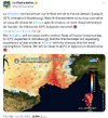
Rotation visible to the naked eye under the Poitiers supercell this evening, the video is accelerated x4There is a strong chance that there was contact with the ground (6:45 p.m. towards La Puye, I no longer have the exact location) @KeraunosObs @meteo60 @MeteoContact
From now on all #Unwetteralarm users can also see what is happening in France/Belgium/Luxembourg. Simply select "France" in the country selection at the bottom left and all products and the view will change.And if you don't have it yet: http://unwetteralarm.com
Powerful HP super cell currently north of Auxerre! We are currently taking shelter under a gas station, a massive downburst is raging with hail up to 3cm
LOL!
Rotation visible to the naked eye under the Poitiers supercell this evening, the video is accelerated x4There is a strong chance that there was contact with the ground (6:45 p.m. towards La Puye, I no longer have the exact location) @KeraunosObs @meteo60 @MeteoContact
From now on all #Unwetteralarm users can also see what is happening in France/Belgium/Luxembourg. Simply select "France" in the country selection at the bottom left and all products and the view will change.And if you don't have it yet: http://unwetteralarm.com
Powerful HP super cell currently north of Auxerre! We are currently taking shelter under a gas station, a massive downburst is raging with hail up to 3cm
Attachments
-
 Screenshot 2023-06-19 at 23-33-55 Sud Ouest Pau on Twitter.png741.1 KB · Views: 60
 -
 Screenshot 2023-06-19 at 23-35-49 Kévin Floury on Twitter.png433.3 KB · Views: 54
 -
 Screenshot 2023-06-19 at 23-36-43 Météo Express on Twitter.png325.2 KB · Views: 53
 -
 Screenshot 2023-06-19 at 23-56-17 La Chaîne Météo on Twitter.png594.8 KB · Views: 59
SlipNet
The Living Force
Here in Pembrokeshire, we've had a gentle heatwave for about 6 weeks. About 23-26C most afternoons. Perfect for sitting in the garden for reading, less good if you've got work of course. We've had very limited rain, which is almost unheard of for us. Hosepipe bans may come into effect later this summer if the rates of rain do not increase. My mood has lifted since this warm wave came in last month, a nice summer without the intense 40C days of last summer would be preferable. God I couldn't stand those conditions.
Trending content
-

-
Thread 'Coronavirus Pandemic: Apocalypse Now! Or exaggerated scare story?'
- wanderingthomas
Replies: 30K -
