What's the weather where you are?

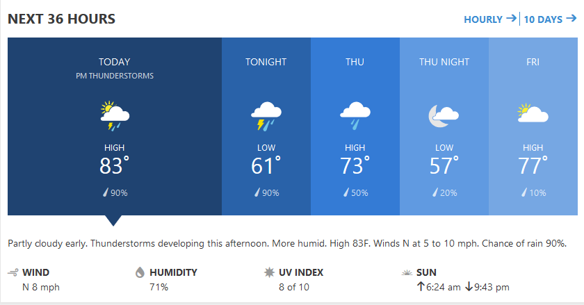
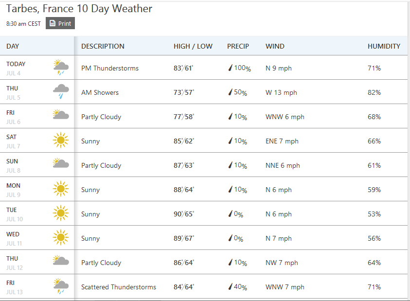
Cold wind, overcast skies west of Ukraine. Weak lightning storm at ~02:00am with transparent clouds - some stars were visible - followed by rapid short rain.

All targets met: temperature + exactly as the 'image of the sky' in the minds eye necessary when configuring the settings. Standing down since yesterday late afternoon, observing only.
 
Cold wave over the Balkan Peninsula. This morning at 8:30 am it was only 10C in Gostivar - western part of Macedonia but the feeling was that it is much colder because of od the north breeze that was constantly blowing.
Heavy and low grey clouds make it feel like it is an late autumn or early winter. I have never experienced cold weather like this at the end of June. According to forecasts, there could be even a snow on a higher mountain peaks.
The Next few days the weather will be as today and with more rain.

That's crazy.

Here in SW France, it appears that Summer finally started about the first day of official summer. However, after a hot day, it got pretty cool last night, down to 16 C. One thing is sure, we didn't have a real Spring.
 
There's a popular proverb in Spain: hasta el 40 de mayo no te quites el sayo ("don't remove the smock until May 40th"). May 40th is June 9th, more and less. It always hold, year after year. Mornings would be very cold until after June 9th. This year, the proverb was unfulfilled. A sign of the time! It was still very cold in the morning until this week.
 
Yester day has been cloudy/thundery/rainy here in Split Dalmatia with some persistent showers after the midday. Borah started to chill the whole area in the afternoon so it cleared The Airs and The Seas by its mighty swirls. Anyway we had a lot of rain in past week or so and day temps are around 30 degrees - quite bearable...

Beach-Dalmatia.jpg
The Pebble Beach in Dalmatia - Pupnatska Luka
 
  • Like
Reactions: Ca.
South Central Wisconsin/USA
Today is starting out beautiful with seasonal temps after a week of cold wet rainy weather. So much rain! The storm cells passing through dumping local amounts exceeding 2" at a time. SHEETS OF RAIN on occasion turning our driveway into a river! Area lakes and rivers are at or over flood stage, with "no wake" rules enforced. Northern Wisconsin and Upper Michigan Peninsula got nailed earlier in the week with training storms dropping up to 7" of rain, which caused localized flooding, many road washouts and over 60 sinkholes!
What's even more odd is that while we were experiencing temps here in the 60's and low 70's, western and Central Canadian provinces had temps in the 80's and low 90's! The forecaster reporting this blamed it on the jet stream being far north.

I've heard the term "1000 year flood event" a few times this past week for the first time ever. It was only within the last 10 years we first heard the term "100 year flood event". What do these terms even mean now a days?

A few headlines:
DNR urges caution while on flooded Wisconsin lakes
MADISON — Heavy rains across Wisconsin have state officials urging boaters and swimmers to be wary while on flooded lakes and rivers.
A slew of June storms have unleashed powerful downpours, causing lakes and rivers to flood, debris to stack up in waterways and water currents to speed up throughout the state. The Wisconsin Department of Natural Resources said Friday the conditions could be dangerous for swimmers and boaters who don’t take safety measures.

Flash Flooding Closes, Washes Out Roads In Northern Wisconsin
The flooding comes just days before the six-year anniversary of the flood that caused tens of millions of dollars in damage to northern Wisconsin and Minnesota when 10 inches of rain doused the Twin Ports region on June 19-20.

Flash flooding has impacted roads in at least four northern Wisconsin counties, including Douglas, Ashland, Bayfield and Iron counties.

Douglas County officials have issued an emergency travel alert and declared a state of emergency, according to Douglas County Emergency Management director Keith Kesler.

"It's a situation where some of the roads are getting undermined and will just suddenly collapse," said Kesler. "When you're driving along, it may look like everything’s fine, but there may not be anything underneath you. We've had several instances both in Douglas and Bayfield County where people have driven through deep water and floated off the road and had to be rescued."

Once-In-A-Lifetime Rains Falling Frequently On Northern Wisconsin
In the last decade, areas of northern Wisconsin have experienced several storms with heavy rains that are only projected to occur once in a lifetime, according to precipitation archives from the National Oceanic and Atmospheric Administration.

An official analysis of the weekend's storms in northern Wisconsin by NOAA confirms that 100 to 1,000-year rainfall events occurred in some areas of the state.

Trying to figure out how to insert images, still, but pictures can be found by searching... some of them are just unbelievable and attest to the power of water.
 
In Brisbane, Australia, we are in a period of very cold temperature. There are multiple days where the lowest temperature goes down to 3 - 4 C, which is the lowest I have seen here (I've been living here for 6 years). The cold periods last longer than usual too. There are people reporting sick, or their children are sick, every day in my office of about 30 people.
 
  • Like
Reactions: Ca.
Very dry in Northern NSW, Australia. Drought is widespread across much of the state, with some areas having their driest Autumn since 1902.

Weather patterns are unusual for the dry conditions, with moist winds providing little to no rain. Underground springs have also been flowing for some time and are usually indicative of a wet pattern.
 
  • Like
Reactions: Ca.
Rather peculiar little heatwave over UK at the moment. Not because of the record June temperatures over northern and western parts of UK per se - but more the fact that the summer temperature variation across the British Isles is upsidedown and backtofront. When UK gets hot, the South, Central and East are almost always significantly warmer than anywhere else across the North and West region - especially the far North and West ie Scotland, Northern Ireland and north Wales (all seeing 30+ degrees) because of the moderating effects of the Atlantic Jet Stream... Yet, the very opposite is in play here - and continuing for several days now, rather than a one-off very brief blip - that has been known to rarely occur, but only one or two pockets aforementioned, and for no more than a 24 hour period.

London and South-East, EastAnglia and South-Midlands, in particular, should be in the 30's currently - with North-England, Wales, Scotland and Northern-Ireland nudging mid to high 20's at best. However, it is the exact opposite - and holding. It seems to be a North Atlantic high-pressure system causing it. 'Tis very odd.
 
In Southern Scandinavia, farmers have begun to harvest grains which makes it the earliest harvest ever. Grains are small, and the harvest will be significantly below normal. Several farms decided to declare bankruptcy already in May, and also in June there have been cases, a trend that will probably continue, as researchers earlier estimated that the drought could lead to losses of more than 750 million Euros. Not surprisingly, June is now set to become the most sunny and the warmest in 26 years.

In Greeland the icecap has begun to melt. It appears the melting process has been dragging its feet, but after two weeks of stagnating ice levels the total amount has begun to drop. Or at least this is what the model says.

accumulatedsmb.png

When I look at the Arctic sea ice extent it appears to be in the low range.

osisaf_nh_iceextent_daily_5years_en.png

In the next image, one can notice where the melting is taking place:
Melt_combine.png


When water from the glaciers ,it can be used for hydroelectric power stations. And it is, as 17 % of the energy in Greenland is generated this way according to Spørg Scientariet: Kan vi udnytte vandkraft fra Grønland?
 
Last edited:
Here in the Rockies this past week (basically the last month) has seen dominance from a cold wet front. Wednesday overnight it was 2c at home (thought there would be frost), the next night it was a little warmer and actually lit the fireplace.

This is the first year in, not sure, 25 yrs or so, whereby there is still significant snow pack laying on elevated mountain slopes (mostly now N, NW, NE aspects). These snows are typically gone or not significant by late May and they are still here. Take a look at the photo from Thursday while in Alberta near Lake Louise - you will note the glacier ice, yet there is plenty of unmelted snow-pack sitting on the ice and on the bare rock slopes to the left and right. You can see the shear-lines that broke off as prior avalanches (they are pretty deep fractures). This snow is similar in other places and even on elevated S, SW aspects there are still slight deposits and many of the the avalanche paths on the other aspects are still loaded. It's basically July, crazy.

It's my understanding that the East of Canada is hitting a heatwave, so it might oscillate West eventually. However, unlike last year (fires), these parts should avoid it for a good part of July based on the rain and cool temps, unless rapid heating happens with lightning intermixed.

Lake Louise Area June 29 2018.png
 
Cold wave over the Balkan Peninsula. This morning at 8:30 am it was only 10C in Gostivar - western part of Macedonia but the feeling was that it is much colder because of od the north breeze that was constantly blowing.
Heavy and low grey clouds make it feel like it is an late autumn or early winter. I have never experienced cold weather like this at the end of June. According to forecasts, there could be even a snow on a higher mountain peaks.
The Next few days the weather will be as today and with more rain.

And just 10 days after this unusual cold wave, today morning at 8:30 Am when I was going to work, the temperature was 29C and it will rise even more during the day. During the weekend we were for a few hours outside the town in a country village visiting our friends and for the first time in my life, I felt so bad after standing on the sun for 30 minutes that I had to wash my face and neck with a cold water just to cool myself for a little. After that, I was feeling so tired.
Such a big change in a such a short time and the sun is just burning very bad.
 
  • Like
Reactions: Ca.
Back
Top Bottom