You are using an out of date browser. It may not display this or other websites correctly.
You should upgrade or use an alternative browser.
You should upgrade or use an alternative browser.
What's the weather where you are?
- Thread starter Maia
- Start date
Palinurus
The Living Force
Source: Coldest April in 30 years not all bad, says biologist
Friday, April 23, 2021 - 10:51 am
Coldest April in 30 years not all bad, says biologist
This April has been the coldest experienced in the Netherlands in the past 30 years. On average this month, temperatures are about three degrees below normal, said Wageningen University biologist Arnold van Vliet to Trouw [newspaper] (in Dutch).
The average temperature for this month will be 6.5 degrees Celsius, Van Vliet estimated. Normally, temperatures in April lie at around 9.8 degrees, and last year April temperatures were about 1.7 degrees above average. An expert from the KNMI said the harsh northern wind is the culprit of this year's cold spell.
“If you look at the ranking of the hottest April months since 1706, this April is ranked 274th, so almost at the bottom”, said Van Vliet.
Van Vliet studies the seasonal recurring events such as the blossoming of flowers and the migration habits of birds. Warm weather in March lured both plants and animals out of hibernation, yet now the cold weather has stunted their development again.
“The growth of many trees, shrubs and plants has almost come to a standstill”, Van Vliet noted. Last year, plants and animals came out of hibernation around three to four weeks earlier.
The cold weather is not entirely bad said the biologist, “Nature is roughly where it should be. Fifty years ago this was normal.” Low temperatures are most likely to damage fruit trees, such as plum and cherry trees who are more sensitive to the cold.
Animals are less affected by the chilly weather. Experts, for example, counted more bumblebees this year than in 2020.
Van Vliet doubted if all insects will survive the cold and hail as the bumblebees did. “The insects woke up early this year and have to survive. I think that will be done with varying degrees of success.”
For birds, the late development of nature works in their favor. Grass grows slower, causing farmers to mow later. This gives young chicks a better survival chance. Warmer temperatures in February and March gave birds also plenty of caterpillars to snack on.
“But then, the weather shouldn’t be too dry”, Van Vliet warned. “In drought, their food supply, particularly worms, crawl deeper into the ground. The true impact this frosty April has on nature will only be seen in hindsight, Van Vliet said. “We won’t find out until later and it’s super interesting.”
Yesterday Mammatus clouds, rare for our places and this time of year, appeared near Minsk. They are not as spectacular as elsewhere on the planet.


The weather in Belarus is cold. For several days at night, frosts down to -3 degrees Celsius, in the afternoon +6 and a cold north wind. The sun appears several times a day, and then sleet and ice on the roads. Cold air masses come from the Norwegian Sea.
According to preliminary forecasts, heat is not expected until the end of April.
The central heating in the apartments has not yet been turned off. Although in 2019 this was done on April 22, in 2020 - on May 8. During the Soviet period, the heating season usually ended on April 15th.
Tuulikki
Dagobah Resident
In the UK we are having wall to wall sunshine and dry weather for several weeks now. No sign of any April showers. This is not good as many plants rely on rain in spring to bring forth their early growth. The ground underfoot is incredibly dry and cracking which is unusual for this time of year. Our weather is now in extremes. We had months of rain during the winter and now it has mostly dried up and the rivers are drying up also. If this weather pattern had been in the summer it would have been a seemingly never-ending heatwave. It may still do that of course but I am hoping not. I am no lover of searing heat. I like a bit of moisture in the air. I believe these weather conditions are something to do with the position of the jet stream as it passes the UK.
PERLOU
The Living Force

Meteo Cagnes-sur-Mer (06800) - Alpes-Maritimes : Prévisions Meteo GRATUITE à 15 jours - La Chaîne Météo
Meteo Cagnes-sur-Mer (06800) - Alpes-Maritimes ☼ Longitude : 7.15 Latitude : 43.66 Altitude : 13m ☀ Provence-Alpes-Côte d'Azur également appelée «...
Εἰρήνη
Jedi Master
On April 18 we had a very strange weather here in Los Angeles. Very strong and dry Santa Ana winds came from the desert all of a sudden, but this time it was different: despite all this busy city noise and traffic piling up not too far from us I could not hear any noise. No birds singing, no animals, it was too unusualy quiet. People generally felt weak, there were interruptions with internet. It felt to me like a geomagnetic storm. I searched the news-no information, except people reporting unusially bright aurora borealis. I had to dig deep to find out that there was indeed a solar storm. Do we have a thread where we can report cosmic weather?
XPan
The Living Force
There is a thread about 'Northern & Australis Lights (aurora borealis)' - it could perhaps be used for ‘geomagnetic / cosmic weather’ events ?
Chad
The Living Force
[...] It felt to me like a geomagnetic storm. I searched the news-no information, except people reporting unusially bright aurora borealis. I had to dig deep to find out that there was indeed a solar storm. Do we have a thread where we can report cosmic weather?
This is another thread for Space Weather kinds of events; and various events are documented there so perhaps it'd be more appropriate than the Aurora thread: Rising fluxes of cosmic rays inside the solar system
XPan
The Living Force
The weather in Stockholm
is clearly on the cold side - and appears to continue so for quite a while. Precipitation has been less than 50% (April) in an area south of Stockholm where I live. And yes, the soil does look dry !
During night time still frost, albeit in the warm city core, slightly above 0°C - in the outskirts down to -5°C yesterday morning. Several times i had the urge of wanting to wear gloves already late evening.
During morning time friendly and sunny, but then clouds with snow showers emerge, especially along the east and north coast of Stockholm. Daytime only around 4 to 8°C only.
Within spectrum of normal weather
I learned that the outer / extreme suburbs of Stockholm (like Tullinge station, an “ice hole” in the SW) can indeed still get very cold this time of the year, and found a notice of -8°C in the 70s, end of April/beginning of May. And moderate frost being more normal than not.
A magnolia tree outside our house, has started to blossom, and many other flowers are in bloom. Very pretty. Lots of smiles in the heart. And lots of birds songs of all kinds, day and night.
I noticed a sense of impatience
in me (or perhaps anticipation ?) which may cloud my judgement of figuring out what is “normal weather” vs “unusual anomalies” these days. On the other hand - i am also a still observer and notice when my ego has a finger in it
The signs of normal vs anomalies are highly erratic without i can see clear patterns - other then that winters gotten clearly warmer up here - with a slight tendency as of lately, that the warming may have leveled out.
Therefore, from time to time I download weather station data to check and learn about past temperatures - but it is tedious to deal with ten thousands of numbers for each station’s daily min and max temperatures and then visualizing / working with them in diagrams / charts.
Sweden has some extreme long observation series, in which the oldest, goes all the way back to 1756. That is a lot of cut and past, back and forth, and crunching numbers as well accumulating them in one chart…. on a 12 year old MacPro.
is clearly on the cold side - and appears to continue so for quite a while. Precipitation has been less than 50% (April) in an area south of Stockholm where I live. And yes, the soil does look dry !
During night time still frost, albeit in the warm city core, slightly above 0°C - in the outskirts down to -5°C yesterday morning. Several times i had the urge of wanting to wear gloves already late evening.
During morning time friendly and sunny, but then clouds with snow showers emerge, especially along the east and north coast of Stockholm. Daytime only around 4 to 8°C only.
Within spectrum of normal weather
I learned that the outer / extreme suburbs of Stockholm (like Tullinge station, an “ice hole” in the SW) can indeed still get very cold this time of the year, and found a notice of -8°C in the 70s, end of April/beginning of May. And moderate frost being more normal than not.
A magnolia tree outside our house, has started to blossom, and many other flowers are in bloom. Very pretty. Lots of smiles in the heart. And lots of birds songs of all kinds, day and night.
I noticed a sense of impatience
in me (or perhaps anticipation ?) which may cloud my judgement of figuring out what is “normal weather” vs “unusual anomalies” these days. On the other hand - i am also a still observer and notice when my ego has a finger in it
The signs of normal vs anomalies are highly erratic without i can see clear patterns - other then that winters gotten clearly warmer up here - with a slight tendency as of lately, that the warming may have leveled out.
Therefore, from time to time I download weather station data to check and learn about past temperatures - but it is tedious to deal with ten thousands of numbers for each station’s daily min and max temperatures and then visualizing / working with them in diagrams / charts.
Sweden has some extreme long observation series, in which the oldest, goes all the way back to 1756. That is a lot of cut and past, back and forth, and crunching numbers as well accumulating them in one chart….
on a 12 year old MacPro.XPan
The Living Force
This is another thread for Space Weather kinds of events; and various events are documented there so perhaps it'd be more appropriate than the Aurora thread: Rising fluxes of cosmic rays inside the solar system
Wonderful link !
 and a lot more activity there about geomagnetic info & events.
Thank you from me as well @itellsya
XPan
The Living Force
Addition: Inner vs outer city temperatures
Today I played with the official temperature charts from 3 stations in/outside of Stockholm, just to illustrate that typical phenomena how much warmer a city core is in comparison to the suburbs (which I consider to reflect climate much more.... real !) Daytime temperatures do not really differ much in general, but at night... it's very different.
As i mentioned before - not much warmth up here: Plenty of frost as soon you get outside of Stockholm (inner) City. The graph is a bit 'squished' because I had to align each station's (automatic generated, and different) temperature scales into one and the same.
lilies
The Living Force
First warm spell of this year continues today in Eastern Hungary. Warm air is blown around under the searing sun. At 04:14am - medium thick mist was visible in the warm and wet night: probably from hours long rain on Thursday. Air feels almost suffocating, giving a reminder of last years hot summer days.

Today I woke up with 8 degrees Celsius, but a very strong wind.
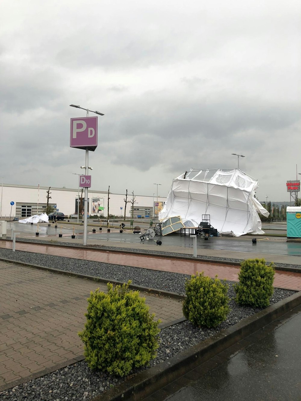
Orange warning is issued Unwetterwarnungen für Bonn
Storm warning level orange from storm / hurricane
Rain, showers or local thunderstorms, with wind 70-90 km / h.
It is due to storm Eugen that sweeps over North Rhine-Westphalia.
The same article states that this was coldest April in 40 years.
Storm gusts of up to 105 km/h are expected.
It looks like middle of autumn and the prognosis for next 10 days is also rain.
Metrist
The Living Force
It's been like normal spring weather, the last couple days were overcast and cooler. Today was about 60° F. There only remains snow in shady spots, and the leaves are about to blossom.
Some days ago, I spotted a 'outsider'. It was sunny and warm - though there was a coolness to the slight breeze, and so I went to the store in flip-flops and shirt. It was not uncomfortable at all - the suns radiance offsetting the cool breeze. Well, I spotted this outsider as I passed by him. He was clothed in a thick winter coat, with his hood up, looking like he was cold - hands in pockets. We both eyed each other like the other was crazy...
Anyway, growing season is coming up, Memorial Day weekend is when everyone starts their gardens. (at the end of May)
Trending content
-

-
Thread 'Coronavirus Pandemic: Apocalypse Now! Or exaggerated scare story?'
- wanderingthomas
Replies: 30K -

-
