Chemtrails? CONtrails? Strange skies...

Hello, I just returned from a neighborhood walk with my family. My little boy pointed out an airplane (as he usually does), and we noticed that it was a low-flying military plane with four smoky looking trails being released from the plane that lingered and sank slowly to the ground. It was zig zagging back and forth over our small town of 5000 (on the NW Olympic Peninsula)....quite low...since we see lots of planes and helicopters here due to our enthusiastic son, we know that we have never seen this before. I was immediately concerned considering the accounts in the Ukraine about planes spraying aerosol over the city before illness outbreaks, another, (although I'm not sure how credible) of such planes being shot down in China. Worst case scenario...if some one is trying to spread another nasty bug....any advice on what to do to protect my family? Safer indoors? Lots of vitamin C & D. Pray..... Any other thoughts? Also, I'm just reporting this so that others may look for similar events just in case it is significant.

Thanks,
Tree
 
Hi Tree

Yes, safer inside when the chemtrail activity is intense. And one of the best ways of strengthening our immunity (besides the things you mentioned) is to keep our spirits high. Do things you love to do. For me, that always means putting on beautiful music, especially music that makes me feel like singing and dancing. Not only does it help to neutralize the fear but it moves energy in a positive way. All of this has a way of transmuting a potentially negative experience into something positive! :)
 
Thanks for the tip, Tree. I live over on the other side of the Sound, and while I haven't noticed anything like what you describe during the past few clear days, earlier in the fall I did see trails up higher in the atmosphere on a couple occasions. I think the Ukraine stories are too uncorroborated to say for sure that we even know they are true. There is a Naval Air Station across the sound from PT that regularly flies training flights out over your area. Were these planes loud, noisy jets? Silver? Grey?
I will definitely keep my eyes open. All the material I have read suggests that airborne spraying is not the most efficient way of delivering pathogens, but rather irritants which attack the immune system to weaken it. Keep an eye out for any effects in the lungs.
 
Thanks to both of your replies. My husband and I were planning on a date night walking out in our town to an art gallery, dinner, and to my office where we can play music uninterupted by our active little boy.... so we decided to stay in and play music at home... something we absolutely love to do! So keeping spirits up is definitely on our itinerary for the night.

Venusian, this was a smaller plane with a grumbly motor sound. Gray I would say, because the sun didn't seem to cast any reflection on it that I could tell. Although I was wearing sunglasses, so I can't be sure of the color since it wasn't directly over our heads....it was several hundred meters to our north and then was coming directly toward us from the west as we scurried back to our house. Our skies have been quite dirty this fall...it annoys us that our sky is consistently glazed over and scratched up with trails by midday (at least that we see on clear days).
_http://www.airteamimages.com/8440.html This plane looks closest from what I can remember.

So we are just enjoying life (as usual) indoors with good food and family fun tonight...a little extra vitamin C and D... I hope this is just a "motherly" panic button, but it doesn't hurt to take a few precautions.

Tree
 
Thanks for that pic of the C-130 transport. The props would explain the 'low grumbly sound' and the 4 props would explain the 4 trails. Good data description, and I appreciate it. Let's just continue to keep our eyes open!
 
Perceval said:
According to the Aden stargate pundits, this is what it looks like. Don't be fooled by the fact that it looks like normal high altitude clouds shaped by ocean winds hitting the mountains along the coast, it's a stargate!

aden_stargate.jpg

Seeing the above which was posted on the Re: Aaron McCollum - Stargate - Yemen thread, made me think about some other very unusual radar images that occurred near a HAARP type facility, the Boeing Systems Support and Operations, Australia's most sensitive Defence communication facilities.

_http://www.colinandrews.net/Cloud-Radar-Circle-Australia-2010-0122.html said:
Two bizarre features seen on radar over the North West and South East of Australia today ( Jan 22, 2010)
The ring over the south east appeared approximately 30 seconds before the bizarre red star over the north west

22012010_1-2_WeatherRadarAu-368x336.jpg


22012010_2-22Jan-2010-1000h-428x334.jpg


l_7451186133a54ef7b764f2069a2f1a4e.jpg


What Now? Seen on radar by thousands today over Australia. What is going on?
Anonymous details received today and new images seen by thousands. Select the image below.
January 22, 2010.
Colin Andrews

I have received E-mails from all over Australia today reporting this rather extraordinary feature captured on
the Australian Government Bureau of Meteorology radar site. This follows a series of so far u-explained
features seen on Australian national radars since the 15th. For a while radar from the Melbourne Airport
facility was out of action ( see below). Another strange ring appeared today over the South East of the
country as seen below.

Today has been very lively surrounding this debate over what some are suggesting are weather modification
experiments now under way over huge country.

I have received data also today that shows the HAARP facility has been ramped up (see their own monitoring
data below).

One anonymous source sent me details that he claims to account for the large ring which started this article,
that which appeared on the 15th. I would not normally publish material from anonymous sources but in this
occasion somehow it seemed right that I should.

Below some of the e-mails today that people who were good enough to let me know what they were seeing on
the national radar in Australia.
[...]
From: Michael Relfe
Subject: RE: The Ring over Australia 2
To: "'Colin Andrews'"
Date: Thursday, January 21, 2010, 4:19 PM
The picture of the "radar rings" is the result of a test period for a Tesla Shield Generator. The
correct question is "What type of government installation is located at the center of that image"

Hi
Similar images can be located on the _www.cyberspaceorbit.com website (it is frozen and still
available even though the creator has passed on) I think they are filed under “radar rings” or
something similar. The give away is the fact that it is a ring, with a clear area inside. As a
former Navy radar technician I am familiar with almost any type of radar return and what is displayed
is actually impossible unless you are familiar with Tom Beardens description of a “fourier
transformed scalar wave” and how it “just appears” at a certain point. A “slow” scalar wave is
transmitted, then a “faster” scalar wave is transmitted. When the faster wave overtakes the slower
wave, the two waves “pair couple” and create a standing wave at that point. If you transmit this with
an omni-directional antenna, you have a “bubble” or “shield” around the transmitting station / area.

Hope this helps. Its nice to see tax dollars at work doing something good for a change.

Sincerely

Michael Relfe
---------------------------
name = Anonamous
email = not entered
comments = Re:Strange Austrailian weather artical.


The Jindalee Operational Radar Network (JORN) consists of two OTHR(over the horizon
radar), one near Longreach, Qld. and the other near Laverton, WA, jointly operated from
the JORN Coordination Centre (JCC) at RAAF Base Edinburgh, SA by No 1 Radar
Surveillance Unit.
The radars are an advanced development of the Australian designed Jindalee radar at
Alice Springs which is in operational use as well as being a research and development
facility used by DSTO for ongoing OTHR improvement.
JORN radars are capable of all weather detection of air and surface targets inside an arc
of up to 3,000 km range extending from Geraldton in the west around to Cairns in the
east. JORN makes a crucial contribution to broad area surveillance of Australia's
strategically important northern approaches.
_http://upload.wikimedia.org/wikipedia/en/8/88/Scanrange.jpg

Australian HAARP?
-----------------------------
name = Paul Harris
email = xxxx known but removed
phone =xxxx known but removed
comments = Colin , have a look at the national weather map right now! Look at the radar and
satellite loop. In particular pay attention to the TC over NW WA, the Low in Vic to the lower RHS
(Gippsland) and see what I mean. Then on the loop turn off the satellite option (ticked box) and
have a look at the two mentioned and in SE Qld around Bris, you will notice Straight (as in ruler
straight) lines of rain in a spiral formation. These have been not only around Bris but around
Darwin as well. I suggest the Doplar (Golf Ball Radar installations deployed all along coast are part
of the Haarp project).
----------------------------------
name = chris Simpson
email = xxxx known but removed
phone = xxxx known but removed
comments = Hi Colin

Could not help seeing one comment re the unusual rings in the Kalgoorlie SW Oz area.

A few years ago , a guy named Harry Mason did some investigating of unusual aerial phenomena
in the Kalgoorlie area. It also covered the use of a sheep station by the japanese sect (aum
supreme?) that set off the tokyo underground gas attack and Mason implied they were using the
station to experiment with some tesla or scalar device.

I am sure I saw it in Nexus mag or hard evidence magazine (aust publications). Also the "over the
horizon radar" I believe is based out near a town called Laverton north of Kalgoorlie.

Sorry that’s all I have.
[...]

22012010_2-813x587.jpg

[...]
name = Jurgen S
email =xxxx known
comments = Dear Mr Andrews,

I have some interesting images taken from the Australian Bureau of Meterology website which are very
very similar to the ones in your story dated 18th January 2010 and headed "There is very strange
weather happening here - please check"

The images i caputred (using microsoft snipping tool) however were taken on the 13th February
2009, still in Western Australia but much further north with the centre of the circle being i believe being
the Halls Creek radar facility...or could be touch further north at the Wynham facility.


The initial story in regards to this so called weather anomaly i encountered via this website, which links
back to your website and subsequent story...

_http://www.realufos.net/

You can imagine my surprise when i saw the image and recalled the images i captured nearly a year
ago now.

Kind regards
Jurgs
------------------------------
Name: Known
Colin,
Look and listen to this..... HAARP was ramped up for two days right before the quake in Haiti (3 images)

The HAARP Induction Magnetometer readings were provided by Prof. Kanji Hayashi of the Department
of Earth and Planetary Physics, University of Tokyo. 3 minutes long...

(Haiti Earthquake & the HAARP Induction Magnetometer Video)

The large ring of black radiating spokes, centered upon a 'Ruby Red Star'
feature as seen today over the north west of Australia is an odd one. Ive been
an amatuar meteorologist now for 40 years and have spent countless hours
looking at weather data from satelliotes and radar sceens and have never seen
such a feature before. I have sent questions to the Australian Government
Bureau of Meteorology asking for comments, a site by the way which is as good
as they come on the subject. I will report back what they have to say.

Closed as of 1630 hrs US eastern time, January 22, 2010.
Colin Andrews
---------------------------------------

hi Colin,

I believe the radar anomaly is due to the ionic atmospheric heater facility (haarp) at Exmouth being used to
modify weather.

The three cyclones present at that time all pretty much fizzled out after the discharge.

You will often see this phenomenon at different locations in Oz.

Many people speculate they may have something to do with mind control.


Have a look at the bernd eastlund patents jointly held by Arco.

I guess you have seen the cheniere.org site?

Exmouth in western australia is home to the naval facility harold holt from which array this transmission
emanates. You can see it very readily on google earth.

They all need an oil or gas field to generate operational power.

A lot of strange aerial phenomena have been seen in this area as well as some super bizarre speculations
regarding the aum shintaro cult doing some weapons testing.
google will tell you about it!

2earupi-HAARP-Australia2-373x314.jpg

Exmouth, HAARP Facility in Australia?

(HAARP CBC Broadcast Weather control part 1 video)
----------------------------------------
From: xx
Subject: Re: Weather Radar
To: > Date: Monday, January 25, 2010, 6:56 PM
Hi Colin,

Will try and dig up what I can. I am going to try and
compile the images I got down the other day from the BOM I
only saved the 'widget' (radar and satellite only, I
have to layer it over the background image of Australia).

The other issue is for example when a weather system is
developing you cannot see the upper atmospheric cloud from the ground because of the low
clouds and or rain. Prior to the system moving in you will see these 'finger/spoke' like wispy clouds
that are almost permanent for a couple days, often if the radar is on all
the time, where you can see the pattern for extended periods as opposed to intermittent bursts,
the clouds will be like ripples. The difference between these and naturally occurring clouds is that
they are almost geometrically shaped and aligned in grids. These grids will occur in exactly the
same place in the same pattern for days. This is not natural.


Will send some more info when I find it.

Regards XXXX Removed
-----------------------------------
When I first saw the pictures of this odd phenomena it was obvious that dust could not have played any part
it's construction,
the radar image was too clear and consistent to be formed by chance alone.

I decided to check back on my previous recordings from my detector of ULF pulses from the Sun.
All those previous 12 hour recordings for January were normal, except for the one recorded on the 15th
January 2010.

Then I realised that the strange doughnut shape object was captured by radar, also on the 15th Jan.
Hardly a coincidence. (See referenced image and info after the chart)


I have designed and built an Ultra Low Freqency detector, along with a unique non inductive magnetic pulse
sensor element.
The sensitivty of the detector is very high, and free from EM radiation interference
I have also successfully recorded ULF magnetic energies, from the Sun, that have been reflected from the
Moon to Earth.

The "ring" is very reflective to Radar energies, possibly in the form of a well controlled plasma magnetic
vortex.
An important point to consider is that the image is consistent, no matter where it is discovered.

Colin, I have attached a chart recording taken on the 15th of Jan 2010 and superimposed on the chart
is a trace recorded on the 24th of January 2010, as a sample of a regular recording of the Sun.

The reason for the narrow vertical nature of the trace is because of the Magnetic Sensor's unusually narrow
beamwidth.

Cheers for now

Brian

STRANGE--magnetic--levels---695x396.jpg


_http://www.bom.gov.au/cgi-bin/nmoc/latest_fwo_loop_R.pl?IDCODE=IDR00000&number=144

(Inserted referenced material below)
"There is very strange weather happening here - please check"

Written at 2230 Hrs (US Eastern) 15th
January 2010.

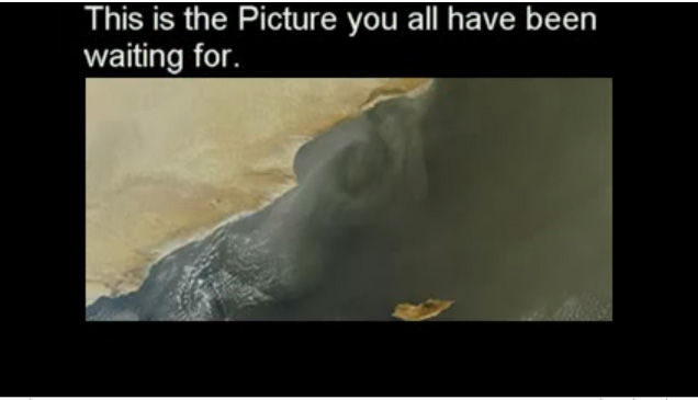
A contact in Australia just alerted me to what he describes as "very strange weather taking place over the south west of Australia". He told me to go to the national weather satellite images if I could not open the images he attached (See left). By the time I had discovered the e-mail and checked, the large clearly defined ring had mostly dissipated but still was just visible on a time loop which was spiraling counter clockwise (Low
Pressure system).

Strange-Weather-Australia16-338x268.jpg


Strange-Weather-AllanHogan--614x399.jpg


The image above is what my contact sent me which shows a wide band ring covering many
hundreds of miles across the south west of Australia with a small dot (presumably cloud)
shown just right of center.

I checked the site several hours later and played a loop of the radar which was on the site at
that time. The radar confirmed the image abvove and showed the ring fading but still visible
over a period of a couple of hours. Regrettably the loop could noty be saved so that I could
share it here. That loop is not now on the site but the satellite image taken at 16:30 UTC is
also very interesting. It shows a very large counter clockwise rotation over west Australia
where the mysterious large ring had appeared. It revealed a small and brief appearance of a
condensation trail formed off the coastline and from the center what had been the huge ring a
series of three small spiraling arms. These arms can be seen moving out of the area and
moving north east. This is one of those rare occasions when I could buy weather
experimentation effects or other experiments being performed by HAARP. It is hoped to receive
an explanation from the Australian Government Weather Bureau for these series of strange
effects. RESPONSE FROM THE BUREAU NOW RECEIVED - READ BELOW
Posted at 4.15 pm US Eastern. January 16, 2010. Colin Andrews (See _http://www.colinandrews.net/Cloud-Radar-Circle-Australia-2010-0116.html for entire article and responses;end of inserted material)
-----------------------------------
After a great deal of research for a week by myself and many others across Australia (thank you), I seem to
have identified the radar stations at the center of some of these effects. The dramatic black radial spokes
surrounding a red ruby star like feature which appeared on the national radar on January 22, 2010 at 00.00 hrs
UTC, emanated from the ground based station at Broome, WA. From the Australian Bureau of Meteorology
national radar mosaic I found the station disconnected from the national system (See Fig 3 below). At 02.00 hrs
the burst effect took place and in filled the gab in the mosaic. Whether the station was taken off line for other
operations to take place of which the radial burst was an artifact or if the effect was itself due to faulty ground
equipment is still not known but during the time the station was either deliberately turned off or failed, a notice
appeared on the system showing the radar was unavailable for reasons not made public (Fig. 07)

BroomeRadar-Off.jpg

Fig. 02 The Australian National Radar Mosaic with the Broome ground station disconnected.

IDR00000_201001220200-IndividualRadarCoverage2010-0122-200UTC.gif

Fig. 03 Burst coming from location of the Broome facility.

australia-radar-map-BroomeOn-209x235.jpg

Fig. 06 Ground based radar stations including Broome.

BroomeRadarLoop2010-0127-OutOfAction-711x263.jpg

Fig. 07 The Broome Radar system shown as currently unavailable for reasons not made public.

From:
Subject: Re: Colin Andrews - Reply
To: "Colin Andrews" <>
Date: Saturday, January 23, 2010, 7:00 PM

Hey Colin,

I did not attach images as when you save them you only get the overlay. The background image is a static of Australia
and the satellite and radar images are superimposed over the same static background image (I know I am probably
telling you how to suck eggs, but jusn case). I can send images if you wish.

Further you will notice an almost permanent "fan" or "circular/spiral" (whatever pattern you wish to describe) over SE
Qld. If you untick the satellite box you will see what I mean, a different type of pattern exists over SW WA as well. But
the other day I saw a pattern I have never seen before. I have images collected going back to 1996.

BTW I used to live in SE Qld for many years, (now in Townsville) and from the ground these patterns are identifiable by
clouds that are in a an almost 'wagon wheel' format all pointing to a centre! Often they are like cloud fingers
, my guess
is the radar at Amberly but with the location and frequency it is more likely the Golf Ball Radar (doplar) installations
placed almost every 500klm around the coast to "track" (read manipulate) our weather systems.

One last note currently TC Olga off North Qld seemed to (the other day) and similar now, have inner circular movement
is clockwise, outer circular is counterclockwise.
Paul
------------------------------
Hi Colin,

Firstly, I do not want to be quoted on anything I say, my job is a bit easy to loose at the moment.

Secondly, I should explain a bit more about our weather radar here, as I cannot speak for the US, as their equipment,
from what I hear, is older than ours in many cases, and is more easily interfered with by outside sources,
which we call AP's, or Anomalous Propagation.

The email you had from the Kalgoorlie Met Office in WA mentioned this (AP), but they did not expand on their
statement.

By this I mean, a radio source within the bandwidth of the radar or sometimes an AP can occur when there is a
weather inversion (i.e. the temperature relative to height rises instead of falls). These can cause false echoes to
appear.

This type of Temperature inversion scenario can occur when the radar’s signal bounces off the inversion, which
creates more AP with “shape” rather than just overall speckle.

I think from memory these type of radar images have only been available for the last 6 or 7 years to the general public
on the Bureau of Meteorology (Australian BOM) website.

The thing is, everyone thinks’ they are an expert, and the Bureau gets complaints and queries from various areas of
the public, but it comes down to people having an “untrained eye” in regard to what you are “supposed to see” from
this equipment.

I think as time goes on, the Bureau has to be more accountable for the money spent, and people want to see more
“real time” of what is happening, rather than having some “expert” interpret for them. The problem is, even the young
meteorologists have to trained on how to interpret the data from these devices, since the technology is not perfect.
The radars just follow the laws of physics.

People can get excited over nothing at times, and essentially the Bureau is making a rod for its own back, releasing
images which might contain AP’s - since they have to continually field enquiries and complaints in this regard.

They then need extra qualified manpower to answer all the oddball questions.

This is not to say that something like a certain frequency signal from some device, say Australian Airforce, (RAF) can't
interfere with the weather radar, it can, and has been known to happen in certain areas. But, for example, in southern
Western Australia there is no Airforce presence, but the image you sent from northern WA is near a couple of big RAF
setups, (Broome, WA) with their own radar, and other transmitting equipment, which might interfere.
The US also share a base up in that area, (much of which is underground, except the big airstrip of course, which is
designed for the space shuttle to land on) so you could have something interfering.

On that note, if there was something fishy going on, it would not get released on weather radar images, that is for
sure. Nothing gets through like that.

As I understand it, the Alaskan Tesla transmitting system which we all know as HAARP transmits at ultralow
frequencies, which I will not go into in this email, but they would never show up effects of on weather radar. It is
designed for sub level use, ie. underwater and through the crust of the earth.
Sometimes it is used for ionisation too,
(upper atmosphere) not sure how and at what frequency. Documentation on this would be hard to get, as it has certain
classifications.

So, if I were you, I would avoid speculating on things which show up on weather radar, as it is too easily misinterpreted.
I would get in contact with someone over there in the US who works in that field, and ask them for input. Preferably
someone older and trained in this field. Someone must be willing to help, and is trustworthy. Even someone retired.

That's all for now, hope this helps,
-----------------------------------------
This Dramatic Spiral Burst known to 'insiders' as The Ring of Fire Fault was observed on national radar over Melbourne Australia today - but then what? Is this the HAARP smoking gun?
By Colin Andrews
posted January 27, 2010.

Its been a very busy twelve days for anybody interested in strange weather effects, possible weather modification experiments
or the secret agenda behind the global HAARP project.

2010-0127-melbourne3-332x283.jpg


Black spiraling radial arms from a much larger ruby red star center, this time over the south west on January 27. The same facility as Fig 02 which
appeared on the 22nd.

(Fig 02)
22012010_2-22Jan-2010-1000h-217x160.jpg


One suggestion received here today is that this phenomenon are electrical discharge patterns shown below - hope to follow up on that idea later.

AnodePositiveSink-E_Sink_Source-355x212.jpg

[...]
As of this posting Ive received a number of confidential messages from technical staff and scientists working
within the Australian Government about these images. One refers to Fig 03:

"This is regarding your radar anomaly images on the 22/1 over Australia. The one over North
West Australia is a fault known by our technicians as "the ring of fire fault". Its caused by sever
arching inside the pulse forming network of the radar. Its nothing suspicious, its just a very rare
fault, and its the first time that its ever happened on one of our radars". ....clip....

Strange indeed that following the events to which he refers a second apparently very rare event took place
five days later (Fig 04 and sequence series Fig 04-01 - 04-04 ).

I have sent an urgent request for information and explanation to one of the top experts in Australia Dr Tom
Keenan who is Leader of the Weather, Oceans and Environment Program in the The Centre for Australian
Weather and Climate Research (A partnership between CSIRO and the Bureau of Meteorology) and is a
Senior Principal Research Scientist employed by the Bureau of Meteorology.

What is so very amazing and alarming to many is the fact that as I watched all this unfold in
Connecticut with many who were watching the radar back ion Australia, I noticed that the
satellite loop showed a new counter-clockwise vortex developing in the lover atmosphere
below where this Ruby Red Star burst had occurred. This new weather system, a low pressure
system can be clearly seen rotating and evolving as it moved with the upper level winds, east.

The loop I saved of this developing weather system is corrupt and I am searching the Bureau archives to
see if I can retrieve another copy - without success at the moment. If anyone can find and save the loop that
immediately followed the radar effect I would be grateful - please make contact with me HERE.

Have we the evidence now to strongly request an official explanation about the roll of HAARP and other
facilities across Australia and around the world? These strange effects have been seen worldwide and only
some have been explained away as radar defects or settings that are too low for effective returns. Like
some of the effects seen over Australia recently, it leaves a lot of questions.

As a personal reaction to what Ive seen in Australia in the last few hours, my hope is that if
indeed this is deliberate government/s driven agendas at work, that they are in the hands of the
good guys. Its possible that as the planet's climate comes under more and more stress and
even possible collapse, we will need all the expertise in weather adjustments we can muster.

If these are the bad guys God knows what they are up to or where they will take us.

Colin Andrews
Posted January 27, 2010

I really don't know what to make of all this other than the C's have been adamant that HAARP has nothing to do with weather and everything to do with mind control. Things just keep getting weirder and weirder.
 
Still more even weirder images.

_http://www.colinandrews.net/HAARP-3.html said:
Broome-2010-0128-284x253.jpg


2010-0128-Broome-Re_Screen_grab2.txt-262x282.jpg


_http://www.colinandrews.net/sitebuilder/images/2010-0128-Broome-Re_Screen_grab2.txt-262x282.jpg

As Ive continued to monitor the weather and national radar system over
Australia with the help of many people in that country since January 16th.
Various strange symbols have appeared, some experts within the Bureau
said these have not been seen before. A new weather system formed
under the event of the 27th over Melbourne which perhaps coincidentally
resembled the spiral seen in the sky over Norway last year. That low
pressure system is now moving north and is likely to be sucked into a
major tropical cyclone Olga positioned over the north of the country.

During this short period the general weather situation has moved from
quiet to very active and in parts serious. Is all this coincidence>

Have we seen the first weather modification engineered in front of our very
eyes? For now lets look at the facts and .....Watch what happens to that
new Low pressure system. Will the cyclone deepen or break up as the
new system approaches - we will be monitoring.

Posted January 29, 2010

On January 29, NASA made comment about the unusual persistence
of the then tropical storm Olga:
NASA
Just like 1980s song by the Commodores, "Three Times a Lady," Olga has become a
tropical storm for the third time in northern Australia. NASA satellite imagery showed
that Olga's center moved back into the warm waters of the Gulf of Carpentaria and it
has regained strength.

NASA's Aqua satellite saw Olga's center re-entering the Gulf early on January 29, and
satellite imagery indicated the storm was strengthening.

Residents of the northern coastal areas in Australia's Northern Territory and
Queensland are again under tropical cyclone warnings and watches, now that Olga is
back in the Gulf. Olga isn't expected to stay in the Gulf more than a day, however,
before it makes landfall near Normanton, Queensland on January 30.

Posted 2200 hrs January 31, 2010
USA eastern.
Colin Andrews

Well we have our answer. We have been monitoring a new Low Pressure
System which mysteriously formed over Melbourne last week. The Low
pressure system which was manufactured or formed dependant upon your
view, when a bizarre spiral appeared on radar over Melbourne on January 27th
2010. The 'Melbourne Low' formed directly over the city and moved up the
east coast when it kicked to the north east honing in on a newly formed
dangerous cyclone 'Olga'. Again dependant upon your view if these events are
natural or are the results of weather modification or even warfare, the low
destroyed Olga or it dissipated.

After this website brought attention to these events and the monitoring of
events was made public as we watched closely the new Low and the Melbourne
Radar, that radar station was taken off line and not made available to the public
- it is still off as I post this update (01.30 UTC Feb 1 : 2200 hrs USA Eastern Jan
31.) What is curious is that the public notice states it was taken out of service
on the 18th of January which preceded all the activity we have been reporting
on, this is patently untrue. The most unusual radar geometry seen came from
this radar station on the 27th. Its as if the Bureau is back tracking and trying to
remove themselves from the data and events. The caption below as seen
throughout Australia on the Bureau Weather Radar network. See also the
weather chart and visible satellite image showing Olga now gone and a new
tropical low forming over the south east. This time however the Melbourne
Radar facility is no longer available to the public to monitor.
[...]
Since my website began monitoring events over Melbourne closely and the public
became engaged in strange weather changes occurring in front of our eyes, the
primary station of interest was taken off stream. What appeared to be an artificially
produced Low pressure system (I called the Melbourne Low) moved up the coast and
towards the cyclone Olga - dangerous storm Olga collapsed suddenly as if bursting a
bubble as the Melbourne Low merged with it.

An unexpected case study into strange weather over Australia. Out of a
single radar ring report, came a persistent cyclone Olga and a weather
busting seventeen days. We just happened to monitor it all unfold. Was it
the perfect cup of tea by HAARP?
-----------------------------

Posted January 29, 2010
Colin Andrews
Two New Bursts over the North West of Australia as the HAARP
Melbourne Low Pressure System heads towards Cyclone Olga - Watch
this low.
Waiting to hear from top expert in Australia.
Colin Andrews
Posted January 29, 2010.
Back to the original article
-------------------------E-mail--------------------------

Forwarded to Colin Andrews:
Radar returns (signals) are composed of microwaves. That goes for weather satellite radars.

The Cabal have orbiting Star Wars weapons satellites some of which have on-board
computer-controlled directed-energy microwave beam weapons.
Thus the Cabal can make hash of weather radar returns (signal patterns), or create
substitute radar returns anytime they wish.
Being egotistical, the Cabal like to show off their shiny new toys.

in the light,

Richard Boylan, Ph.D.

After this website brought attention to these events and the monitoring of
events was made public as we watched closely the new Low and the Melbourne
Radar, that radar station was taken off line and not made available to the public
- it is still off as I post this update (01.30 UTC Feb 1 : 2200 hrs USA Eastern Jan
31.) What is curious is that the public notice states it was taken out of service
on the 18th of January which preceded all the activity we have been reporting
on, this is patently untrue. The most unusual radar geometry seen came from
this radar station on the 27th. Its as if the Bureau is back tracking and trying to
remove themselves from the data and events. The caption below as seen
throughout Australia on the Bureau Weather Radar network. See also the
weather chart and visible satellite image showing Olga now gone and a new
tropical low forming over the south east. This time however the Melbourne
Radar facility is no longer available to the public to monitor. The link to the
national network is :
Tropical cyclone Olga now destroyed over the northern parts as a new tropical low forms over the eastern
sea boards but this time the Melbourne radar facility has been taken off stream and the public can not
monitor events from that region as we did last week. The Bureau Site is HERE
Since my website began monitoring events over Melbourne closely and the public
became engaged in strange weather changes occurring in front of our eyes, the
primary station of interest was taken off stream. What appeared to be an artificially
produced Low pressure system (I called the Melbourne Low) moved up the coast and
towards the cyclone Olga - dangerous storm Olga collapsed suddenly as if bursting a
bubble as the Melbourne Low merged with it.
Updated
January 31, 2010
Updates below
On January 29, NASA made comment about the unusual persistence
of the then tropical storm Olga:
NASA
Just like 1980s song by the Commodores, "Three Times a Lady," Olga has become a
tropical storm for the third time in northern Australia. NASA satellite imagery showed
that Olga's center moved back into the warm waters of the Gulf of Carpentaria and it
has regained strength.

NASA's Aqua satellite saw Olga's center re-entering the Gulf early on January 29, and
satellite imagery indicated the storm was strengthening.

Residents of the northern coastal areas in Australia's Northern Territory and
Queensland are again under tropical cyclone warnings and watches, now that Olga is
back in the Gulf. Olga isn't expected to stay in the Gulf more than a day, however,
before it makes landfall near Normanton, Queensland on January 30.

A Cyclone Warning remains in effect for coastal and island communities from the
Northern Territory/Queensland border to Kowanyama extending inland to Croydon in
Queensland..... Full report:

_http://www.nasa.gov/mission_pages/hurricanes/archives/2010/h2010_Olga.html

Newspaper report about Olga HERE
Updated
February 1, 2010
An unexpected case study into strange weather over Australia. Out of a
single radar ring report, came a persistent cyclone Olga and a weather
busting seventeen days. We just happened to monitor it all unfold. Was it
the perfect cup of tea by HAARP?

Final Comments:
By Colin Andrews
Posted February 1, 2010

From an almost casual report of a strange but by no means unseen before radar design
over the south west of Australia on January 16th 2010 came a whole series. These grew
over the days in complexity and rareness, several apparently never seen before. During the
17 days of study a very persistent tropical storm Olga appeared on the scene. A new Low
pressure system formed directly under the strangest of all radar patterns over the south
east which headed towards Olga. Then it was just like watching an Englishman working with
a tea bag to obtain a perfect cup of tea for his taste. Tropical storm Olga seemed
manipulated and maneuvered into a Cyclone which then became too strong for his taste and
so a new Low was added to the cup to adjust that strength. After all was said and done, the
taste was perfected and in so doing instead of wide spread damage caused to large parts of
Australia, a good soaking was given to seriously parched areas suffering water shortages in
that country. Like the unbelievable 'antics' of Hurricane Katrina in 2005 which went into a
hold pattern over the Carolina coast as its strength and course seemed to be fine tuned
these huge and powerful systems looked like they were different to all the rest. Like they had
a hand on them.

Whether this study along with others can support a case for weather engineering at work I
don’t know but many aspects of this period have been fascinating and rest here to be tested
again in the future. HAARP exists and its implications are unknown but to many its existence
with no form of controls by our representatives is very concerning. God or a higher
intelligence will by some also be a contender for these events but for now we know that we
are a planet and species in rapid transition and so new signs of change can be expected. It
would probably be more assuring if we knew they came from nature herself.
[...]
2010-0202-Ring-449x505.jpg


A new ring captured to the north of the old Cyclone Olga, appearing to nudge it
south towards the very place spot the new Melbourne Low formed January 27,
just six days ago BEFORE the big weather buster cyclone Olga formed.
Thank you to those observers in Australia who are continuing to watch the
weather changes taking shape.
 
The saga continues:

_http://www.colinandrews.net/HAARP-4.html said:
"Houston we have a problem" – HAARP or not the Australian
National Weather Radar Network goes into meltdown after the
strangest 18 days on record. Official statement admits they have
an "Unexpected problem". It begins to look like more than cyclone
Olga was being controlled.
Posted February 4, 2010
By Colin Andrews

OK, so much has happened that has to be classed as mysterious since January
16th that we need again to take stock and be sure we are not making this up.

Be sure to look at the previous page and the recap. Lets pick this up from
February 2, 2010.

Questions from myself and other residents within Australia began falling into E-mail
In-boxes of the Bureau of Meteorology asking for explanations about these bizarre
radar patterns. There have been a few replies but ostensibly you will see that they
generally claim that individual radar equipment has a problem or that the radar rain
return adjustments were set too low. Still the strange returns were seen and not
from one radar station but many. Why then was this problem now suddenly and
mysteriously wide spread across the continent? It was not just strange symmetrical
patterns that were unusual and according to some experts unique but the weather
itself was bizarre and even worrying.

Tropical storm Olga strengthened and weakened three times and was noted as
unusual by NASA. The storm grew into a cyclone and then began its hand held
behavior into the very regions that seriously needed the water. A new Low system
formed over Melbourne within hours of a huge energy pattern appearing on radar
over the city. That low, called here The Melbourne Low moved north and then west
where it modified Olga which itself then began its move back towards Melbourne. A
whole series of new 'energy bursts' seen on radar (perhaps unexpectedly and
unintentionally) seemingly positioned like billiard balls pushing the weather busting
Olga directly over the birth place of the Low and out to sea. Mission accomplished
perhaps.

If what we have watched for 18 days has been weather modification experiments,
we have for the first time secured many of the steps and opened up a Pandora's
box of questions.

As the public became more and more aware of this website project, we began to
monitor more and more radar stations being taken out of service. If these were
because of sudden faults, there were a lot of them. On February 2, 2010
observers on the ground who were helping me watch events counted nine stations
out of service. That's a lot of radar stations to suddenly go into meltdown or were
they taken down because unexpectedly they were showing too many details of
secret work? There are technical questions raised here that require an official
explanation. We will see if we get answers. Frequencies involved, the type of
problem experienced and why so wide spread? etc..... And obviously there might
be a normal rational explanation.

The story continues. Many thanks to the many volunteer observers across
Australia who have been watching each radar loop.

Meltdown: Large number of radar stations go down.
--------------------------------------E-mail---------------------------------------------
Feb 2, 2010
Hi Colin,

Just read your posts concerning the (BOM) radar abnormalities in
Australia - & as I live in Oz, I have noticed these strange readings
over the last week also. At 10.49am today, I noticed that a large
number of radars where 'offline/unavailable' & thought this was
highly unusual. They include stations for: Geralton, Albany,
Esperance, Ceduna, Melbourne, Alice Springs, Carnarvon, Broome &
Moree? Also yesterday there was the flat 'white rings' around the
Longreach radar? I find it hard to believe all these stations can
be offline around these different states at the same time due to
'technical difficulty' - What is really causing this????
Margaret.

2010-0202-2nd-febuary-01-285x285.jpg


White ring seen over Queensland. Taken February 2, 2010.

2010-0203-20-hrs-after-doug-284x282.jpg


20 hours after the white ring on left. The image
above appeared February 3rd centered on
Townsville - Taken 2.30 pm Melbourne time. See
also below on left - close up on local radar.

2010-0203-25-hrs-after-doug-279x283.jpg


25 hours after the image seen on left. This radar
grab taken February 3, 2010 and centered upon
Longreach. See below right for local radar.

2010-0204-brisbane-black-ci-387x370.jpg


The following day (4th) the remains of cyclone Olga finally crosses
directly over the same spot where the Melbourne Low formed under a
bright red spiral symbol on January 27th (See Fig 4 previous page). As
the storm moves off land to the south east yet another new pattern
appears - bright blood red circle appears over Brisbane - Yes
"Houston we have a problem".

NOTE: After 18 days of numerous designs seen on the national radar system
and explanations of call kinds offered, today a banner has appeared across the
top of the Bureau system seen throughout Australia. Read below: The
statement suggests they don't yet have an explanation for the wide spread
phenomenon we have been monitoring since January 16th.

2010-0204-technical-issues-682x355.jpg

------------------------------------

Right now again, near Brisbane this time...Thursday, February 04, 2010
2:00:59 AM
From: xxxx
To: Colin

and take a look at
_http://www.asyura2.com/09/warb2/msg/719.html
though it's all in Japanese...

Similar RING was seen in Japan on Japanese MET Agency's radar page
back on 04 AUG 08 AND 25 SEP 09.

After the first one, there were some earthquakes in Japan, AND a few
days after the latter, there came that Samoa.


Not 100% sure, but it seems they (the ring) were caused by a Japanese
facility called MU Radar of Kyoto University, located in Shiga Pref.

You connect three buildings(with bluish roofs) and make two triangles,
then you get a STAR OF DAVID just like, the Aussie equivalent in WA...
(Editor: See photos below)
Anyhow, take a look at
_http://www.bom.gov.au/products/national_radar_sat.loop.shtml NOW if possible!!
If not, the attached image below will tell you what it looked like...

Chihaya

2010-0204-JapanSite-mu-smal-376x317.jpg

MU Radar at Kyoto University - Japan

2010-0204-JapanEquive-381x314.jpg

Exmouth facility - Australia.
 
Read the Comet series linked on the left of the sott page.
 
Laura said:
It seems clear to me that it is the solar system environment because of the climate changes that have been reported on Mars, Jupiter, etc. Not to mention the startling increase in the numbers of moons counted around the outer planets (and I don't think the smaller numbers from yesteryear are just observational deficiencies, either!)

Again, I think this connects us to the "chemtrail" phenomenon and the recently categorized weird clouds (forget what they are calling them) that are way more common nowadays than they used to be, not to mention the more frequent appearance of noctilucent clouds.

All the pieces of data put together point to strange changes in our atmosphere that nobody seems to be talking about - all you hear is "global warming! global warming!"
[...]
I've been saying for a number of years now that there is something very strange about our atmosphere that is the background for so-called chemtrails, strange cloud formations, strange weather and so on. The Cs have been talking about these things for years now. They came right out and said "sudden glacial rebound" back in 1997!!!

When these phenomena and what the Cs have said, are compiled with a LOT of research (read the comet series linked on the left of sott.net), it seems reasonable to conclude that we are, most definitely, dealing with some interesting phenomena, but nothing that cannot be explained by things that have happened before.

Interesting that this image has the golden mean pattern:

2010-0128-Broome-Re_Screen_grab2.txt-262x282.jpg
 
is this new type of clouds caused by the incoming wave?
if not, what is it caused by? does it have a metaphysical or an environmental origin?

http://www.tutztutz.com/2010/02/asperatus-a-new-cloud-type-discovered/
http://cloudappreciationsociety.org/gallery/index.php?x=browse&category=52&pagenum=1
 
pinredpurple, I've merged your topic with one of several on this type of cloud. In the future, if you use the search function at the top of the page, you can find existing topics on the topics you'd like to post about, instead of starting a new thread.
 
ok. i read the link i think it answers my questions. so basically from what i understand they are symptomatic of the metaphysical changes/wave, yes?

the reason those clouds are so fascinating to me is because they started appearing in my dreams in the early to mid 90'ies. they always came in a deeply hopeless, apocalyptic context. those dreams were so intense that i remained shaken for weeks at a time sometimes. i was dreading those dreams. the clouds were all-devouring, evil to the core, total destruction and mayhem and hopelessness. and they seemed to have a consciousness, they seemed to attack people, especially me personally - all in my dreams of course.
then to my surprise a couple of years later i started seeing them in real life in the skies. not the whole sky was covered, only a part here and there. for that reason when i saw them i never felt the dread and horror of my dreams but they were odd enough to totally hypnotize me. i had never seen anything like this in the sky. in my mind clouds should not look like this. it was very unnatural and strange.
the dreams came back. maybe 2 or 3 times in the last 3 years. but each time they were less and less menacing. i remember watching them in my dream and thinking "hm, you're supposed to be really evil and try to grab me and destroy me, but you seem so meek now ...". in the last dream i even was jumping up and trying to grab them to entice them to be evi!? i guess i wanted to see some action. but nothing, they would not be provoked and instead decided to pass by and dissolve into regular non-threatening clouds.
when i first saw those pictures i could not believe my eyes. they were real! and i still cannot look at them properly cause i get the same feeling of dread, destruction and terror.
so what i was asking myself if my dreams mean that the worst case scenario is not gonna happen? that the danger of catastrophic earth events associated with the coming wave have passed? or was it only concerning me personally? that i'm not in danger anymore.
well, i guess only time will tell...
 
pinkredpurple said:
ok. i read the link i think it answers my questions. so basically from what i understand they are symptomatic of the metaphysical changes/wave, yes?

the reason those clouds are so fascinating to me is because they started appearing in my dreams in the early to mid 90'ies. they always came in a deeply hopeless, apocalyptic context. those dreams were so intense that i remained shaken for weeks at a time sometimes. i was dreading those dreams. the clouds were all-devouring, evil to the core, total destruction and mayhem and hopelessness. and they seemed to have a consciousness, they seemed to attack people, especially me personally - all in my dreams of course.
then to my surprise a couple of years later i started seeing them in real life in the skies. not the whole sky was covered, only a part here and there. for that reason when i saw them i never felt the dread and horror of my dreams but they were odd enough to totally hypnotize me. i had never seen anything like this in the sky. in my mind clouds should not look like this. it was very unnatural and strange.
the dreams came back. maybe 2 or 3 times in the last 3 years. but each time they were less and less menacing. i remember watching them in my dream and thinking "hm, you're supposed to be really evil and try to grab me and destroy me, but you seem so meek now ...". in the last dream i even was jumping up and trying to grab them to entice them to be evi!? i guess i wanted to see some action. but nothing, they would not be provoked and instead decided to pass by and dissolve into regular non-threatening clouds.
when i first saw those pictures i could not believe my eyes. they were real! and i still cannot look at them properly cause i get the same feeling of dread, destruction and terror.
so what i was asking myself if my dreams mean that the worst case scenario is not gonna happen? that the danger of catastrophic earth events associated with the coming wave have passed? or was it only concerning me personally? that i'm not in danger anymore.
well, i guess only time will tell...


Perhaps the intensity of this phenomena is becoming externalized and localized, a merging of the inner and outer visual fields? This may suggest the danger is becoming more "real" by the moment, OSIT.
 
Having lived in southern California, when the chemtrail phenomena commenced in the mid and late 1990s, I am relatively certain that this phenomena is quite real. There were mornings when the skies were pristine clear, then the trails began and within a couple of hours the sky was a greasy gray. There were times when the sun, viewed through heavily polarized sunglasses on days when the trails had transformed the sky to haze, would display an irregular sundog effect, but with the appearance of a greasy rainbow oil slick on water. I have photographs of planes flying at the same altitude and direction; one leaving a normal dissipating contrail, the other laying down the typical non-dissipating chemtrail (below).

Natural News addresses the issue today:

Eyes Wide Shut: Disease and Death from the Sky

Saturday, June 05, 2010 by: Paul Fassa, citizen journalist

_http://www.naturalnews.com/028930_chemtrails_chemicals.html

(NaturalNews) There is one source of toxins and heavy metals that is virtually ignored by most health conscious people focusing on existing food, drug, and environmental toxins. Yet it exists as the unnoticed elephant in the room. It appears very often in most skies throughout the western world. Those who dare document their existence call them chemtrails.

Contrails or Chemtrails?

The difference is obvious to the naked eye. Contrails appear only at high altitudes, are thinner or more narrow than chemtrails, and dissipate very quickly. They are never longer than a few aircraft lengths, and they don't linger at all. Contrails are nothing more than exhaust vapors that have crystallized in the upper altitude's cold air, and those small ice crystals melt or evaporate quickly.

Chemtrails are much wider and thicker. They are long enough to cover the sky from horizon to horizon. As they linger, they get even wider, and they tend to drift toward the ground or space out into artificially created cloud patterns. What separates these patterns from contrails further is that they are not normal aircraft traffic patterns.

These differences are not from atmospheric conditions. You can see chemtrails and contrails in the same sky at the same time.

Chemtrails have been observed and photographed with tic-tac-toe patterns or huge Xs in the sky. Aircraft are often seen making U-turns to spray another trail. And unlike contrails, they can be shut off and on again.

The Toxins

Analyzed residues from chemtrails always show high levels of barium, aluminum oxide, strontium, and titanium, all heavy metals that we breathe in every time they spray. If they are apparently sprayed from or close to the engines, then traces of an extremely toxic banned jet fuel element, EDB or dibromoethane, are found in collected specimens.

These are in small enough particulate forms to breath in and contaminate soils and waters. Barium salts have been aerosol sprayed as chemical warfare agents. Barium can be more toxic than lead. Chronic aluminum exposure can cause all sorts of neurological damage and dementia. EDB is a carcinogenic nerve gas agent that causes severe neurological damage.

Even if you are not feeling immediate effects from these toxins, your immune system is compromised by constantly fighting them off. One needs be almost constantly detoxing!

How Come?

The exact hows and whys are unknown. That's due to information being mostly squelched, ignored or marginalized by the mainstream media, and by government agencies at all levels. It's like a vaccine injury cover up deja vu.

Recently, the City Council of the remote and pristine Mt. Shasta, California, dismissed factual reports of wildlife dieing off from these very toxins gathered from streams, rivers, and mountain top snow. The local paper made the chemtrail activists look like conspiracy kooks.

A retired conservative couple in rural Canada became concerned with the chemtrail activity over their homestead a few years ago. They took their years of acquired information, including photos and specimens, to a regional health agency, and they were dismissed as cranks.

When occasionally cornered with a large public outcry, the higher level agencies claim that chemtrails are part of a military exercise for radar jamming using metal particulates, or that they are geoengineering with aerosol sprayed metal particulates to create an atmospheric shield for global warming prevention.

So ultimately they're not denying the existence of chemtrails. They are leaving that denial up to all those who won't look up or even accept their existence as other than contrails when it's directly pointed out to them in the sky. See for yourself.

Educate yourself further with these article sources:

Beware of Poisons from the Sky
_http://www.naturalnews.com/026200_h...

Chemtrail Central
_http://www.chemtrailcentral.com/

Barium Blues
_http://www.bariumblues.com/

Clifford Carnicom's Scientific Studies
_http://www.carnicom.com/elf9.htm

The pic, below, shows a plane (small circle upper left) leaving a normal contrail, following the same relative direction and altitude as a recently laid trail. The big circle in the center of the pic demonstrates the on/off ability and the short parallel grid pattern. There was another one of these short parallel groupings which can be seen at the top, but is directly in my line of sight with the sun.
 

Attachments

  • chem 181105 montaigu DSC01238 M R.jpg
    chem 181105 montaigu DSC01238 M R.jpg
    125.9 KB · Views: 6
Back
Top Bottom