Has a name now, Ciarán.According to Nahel Belgherze ( @WxNB), weather models are converging towards the appearance of a “weather bomb” (equivalent to hurricane cat. 1) in Western Europe next week. France would be concerned.
You are using an out of date browser. It may not display this or other websites correctly.
You should upgrade or use an alternative browser.
You should upgrade or use an alternative browser.
Crazy Storm Weather and Lightning - Global
- Thread starter mabar
- Start date
Storm Ciarán will be very far from the intensity of the storms of 1999. However, it promises to be strong over Brittany and the Channel coasts. More info at https://meteo-express.com/article/semain
Ahead of the cold front, instability increased between #Provence and the Rhône valley. Forts #orages go up from Bouches-du-Rhône to #Vaucluse . The strong episode #pluies is taking place in Rhône-Alpes. Be careful on the roads this afternoon in the southeast!
Be careful due to the #orages which erupts in the south-east this afternoon where downpours can cause significant runoff. Between 25 and 30 mm of rain has just fallen on #Orange , #Marignane , #Carpentras and Salon-de-Provence.
At least 51 heads of cattle die from a lightning strike in Cororo, San Pedro, #Paraguay . (October 28, 2023). #Powerful #Ray #Lightning #Climagram #zabedrosky
Arctic air mass spreads over North America to reach northeast Mexico
Pilar is expected to cause heavy rains and flash floods in parts of Central America in the coming days
Pilar is expected to cause heavy rains and flash floods in parts of Central America in the coming days
Satellite estimates indicate that winds have increased to 85 km/h.
Strengthening is expected for 24h more, and #Pilar could reach hurricane strength on Tuesday. Weakening is anticipated to begin Wednesday and continue through Thursday.
Northern and central Italy were covered today by storms with heavy rain.
Northern and central Italy were covered today by thunderstorms with heavy rain and strong winds, in some places even hail. Due to the storms, a red storm warning is in effect today in the Emilia-Romagna region and an orange warning in Tuscany, Veneto, Liguria and Friuli-Venezia Giulia (FJK), reports Italian news agency Ansa.
In Terenzo, south of the city of Parma, in the Emilia-Romagna region, the bridge over the Tara river partially collapsed due to rising waters. Schools in the vicinity of Parma are closed today due to bad weather conditions.
Significant increase of rivers expected
In several places in Tuscany, including the port city of Livorno, schools are closed today. Ansa also reports that rivers are expected to rise significantly in this Italian region.
An orange weather warning also applies for FJK due to heavy rain and strong winds in some coastal areas from noon today until midnight Tuesday. The warning is yellow for Tržaška, especially due to high tides and sea flooding, reports Primorski dnevnik.

 maribor24.si
Translated with Deepl
Northern and central Italy were covered today by thunderstorms with heavy rain and strong winds, in some places even hail. Due to the storms, a red storm warning is in effect today in the Emilia-Romagna region and an orange warning in Tuscany, Veneto, Liguria and Friuli-Venezia Giulia (FJK), reports Italian news agency Ansa.
In Terenzo, south of the city of Parma, in the Emilia-Romagna region, the bridge over the Tara river partially collapsed due to rising waters. Schools in the vicinity of Parma are closed today due to bad weather conditions.
Significant increase of rivers expected
In several places in Tuscany, including the port city of Livorno, schools are closed today. Ansa also reports that rivers are expected to rise significantly in this Italian region.
An orange weather warning also applies for FJK due to heavy rain and strong winds in some coastal areas from noon today until midnight Tuesday. The warning is yellow for Tržaška, especially due to high tides and sea flooding, reports Primorski dnevnik.
VIDEO: Naše sosede danes zajela neurja
Sever in osrednji del Italije so danes zajela neurja z obilnim dežjem in močnim vetrom, ponekod tudi točo.
maribor24.si
Translated with Deepl
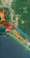
This kind of buildings are at Diamante area marked as orange - damaged . I guess is because the structure remained.
Images from here:Copernicus EMS Rapid Mapping Activation Viewer
Attachments

● Italy
● Ireland
Heavy floods due to extreme rains on the Milano Porta Garibaldi railway station in the Milan of Italy(31.10.2023)
● Ireland
Newry in Northern Ireland this mornint....
Newry is a city in Northern Ireland, standing on the Clanrye river in counties Down and Armagh.
It’s looking increasingly probable that Red wind warnings will be issued by Météo-France for Brittany, NW France given the potential for gusts in excess of 160 km/h (100 mph) along the coast early Thursday morning. Storm surge is also a concern. Storm Ciarán is shaping up to be a very impactful storm for parts of northwest Europe.
UPDATE
Tropical Storm #Pilar near the coasts of #Guatemala#ElSalvador
and #Nicaragua
in the Pacific Ocean.
-Winds 85 km/h
-265 km SSW of #SanSalvador
-390 km W of #Managua
Threat of heavy rains and flash flooding continues in parts of Central America.
CAUTION

Very, very high waves, 45-50 ft??, like 14-15 meters. Not just France.
Entre Wednesday evening and Thursday morning, storm #ciaran will hit the north-western quarter of the country with very strong gusts of wind.
A wave-submergence phenomenon, associated with very high waves, is expected on the Atlantic seaboard and the English Channel.
vigilance.meteofrance.fr
Storm Ciarán: Authorities warn of more disruption after heavy flooding hits country’s east coast
Regions across the country were on Tuesday grappling with significant damage caused by flooding after a month of sustained rainfall, as the threat of more heavy showers in the coming days loomed.In Northern Ireland, Newry experienced “unprecedented levels of flooding” after the city’s canal broke its banks overnight, with several streets in the city centre left under water on Tuesday. In Banbridge, Co Down, the Police Service of Northern Ireland (PSNI) warned on Tuesday afternoon that the level of the River Bann had risen “dangerously high”.

Storm Ciarán: Authorities warn of more disruption after heavy flooding hits country’s east coast
Newry city centre flooded, bridge partially collapses in Co Louth as several rain and wind warnings remain in place from Met Éireann
Flooding inside the McCartan Bros. facility in the town of Newry, Northern Ireland
 Storm Ciaran.
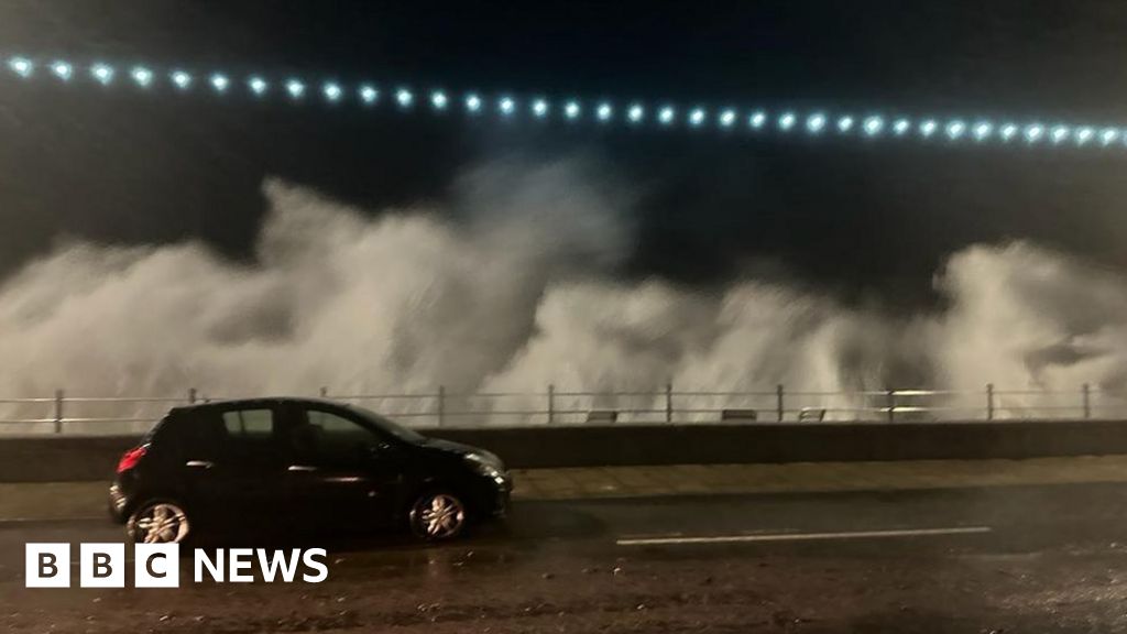
Storm Ciarán: Violent winds lash southern England and Channel Islands
Schools will close and severe travel disruption is expected as 95mph winds and flooding are forecast.
 www.bbc.com
"Shelves have been left empty at supermarkets across Jersey, including Waitrose in St Brelade"
Snip:
The Met Office says the UK has provisionally recorded the joint-sixth wettest October on record after the heavy rain brought by Storm Babet.
Gusts of 70mph (112km/h) are now possible on exposed parts of the south coast of England, with 20-30mm of rain expected in southern and western areas.
A red wind warning, the highest level, has been issued by Jersey Met for Wednesday night into Thursday, with storm-force gusts, heavy rainfall and coastal flooding.
Key developments include:
Yellow rain warnings have been issued for eastern England, London, the South East, South West, North West, West Midlands and Wales from 18:00 on Wednesday.
- Schools across Southampton have announced they will close on Thursday and not reopen until Friday, as a major incident is declared in Hampshire
- Storm Ciarán conditions on the Channel Islands are predicted to be the worst in more than 36 years. Main coastal roads on Jersey will be closed later and schools and the airport shut down on Thursday
- Alerts for the Essex coast have been upgraded to amber from 06:00 GMT to 17:00 on Thursday
- Southern Railway has urged commuters to work from home, warning it would be unlikely to provide rail replacement transport
- People in Jersey and Guernsey have also been asked not to stockpile goods after supermarket shelves were stripped
- Residents in Swindon have been handed more than 200 sandbags while council teams clear gullies and drains
Yellow warnings of wind have been issued for the East of England, London, South East, South West and Wales from 21:00 on Wednesday to 23:59 on Thursday.
In Scotland, a yellow warning of rain has been issued for parts of south west, central and eastern areas from 03:00 to 15:00 on Wednesday, and for the south west and Lothian Borders from 06:00 Thursday to 06:00 Friday. An earlier warning for rain in Northern Ireland has been cancelled.
● Paraguay
500 families affected by flooding in Ayolas
The intense flooding of the Paraná river also left several families affected in Ayolas, and 500 families have already been evacuated from critical areas. The normal flow of the river in this area is 1.80 meters, but with the rains it rose to 6 meters.
According to estimates, the river level reached 6 meters, when in normal conditions its level is 1.80 meters, which gives an idea of the magnitude of the phenomenon, which could even worsen as forecasts indicate more rains in the coming days.

 npy.com.py
500 families affected by flooding in Ayolas
The intense flooding of the Paraná river also left several families affected in Ayolas, and 500 families have already been evacuated from critical areas. The normal flow of the river in this area is 1.80 meters, but with the rains it rose to 6 meters.
According to estimates, the river level reached 6 meters, when in normal conditions its level is 1.80 meters, which gives an idea of the magnitude of the phenomenon, which could even worsen as forecasts indicate more rains in the coming days.
500 familias afectadas por inundación en Ayolas - Noticias Paraguay
La intensa crecida del río Paraná también dejó a varias familias afectadas en Ayolas, siendo 500 las ya evacuadas de las zonas críticas. El caudal normal del río en esa zona es 1,80 metros, pero con las lluvias subió a los 6 metros.
npy.com.py
Storm Ciaran in France
Storm Ciarán Is now slamming northwest France with sustained hurricane force winds likely occurring. Red wind warnings are in effect. A high-impact wind event is unfolding.
Strong wind begins to affect northwest #France tonight due to the arrival of storm #Ciarán. This is the view from the webcam in Carnac, Brittany (Nov 1, 2023). #StormCiaran
So the situation due to storm Ciaran in Larmor-Plague, Brittany region, department of Morbihan, #France
Storm Ciaran in France - List of locations in Brittany (and low Normandy) with the strongest gusts (several records broken):

Edit: Added Normandy
Storm Ciaran hit on Wednesday night, with violent winds of up to 207 km/h.
The island of Batz (195 km/h), Pointe Saint-Mathieu (193 km/h), Brignogan (190 km/h) and the island of Ouessant (185 km/h).
#Ciaran #TempeteCiaran
Gusts recorded as #Ciaran passed through until 8:00 am this morning. Historic storm in Finistère and northwest Côtes-d'Armor, violent in the Channel.
1- #Ciaran At 6am, a 21 m wave was measured off the coast of #Finistère !
2- Significant wave height > 11 m at Pierres Noires buoy (Ouessant) with at 6:00 am a maximum height recorded of 21 m! #Finistère #Ciaran
Storm Ciaran : Spectacular sea foam at Kerroch-Ploemeur ( Witnesses )
Storm Ciaran's strong winds caused spectacular sea foam at Kerroch, near Ploemeur in Morbihan.
#TempeteCiaran #Ciaran #StormCiaran
Edit: Added Normandy
Last edited:
Trending content
-

-

-
Thread 'Coronavirus Pandemic: Apocalypse Now! Or exaggerated scare story?'
- wanderingthomas
Replies: 30K -
