Crazy Storm Weather and Lightning - Global

A new storm is forming that could affect the coasts of Oaxaca, Chiapas and again Guerrero in Mexico.

Attention - Coasts of Chiapas, Oaxaca and Guerrero. The storm zone in the Pacific presents much greater organization for a very soon strengthening. It should not take long for the NHC to declare it as a tropical depression or tropical storm.
 
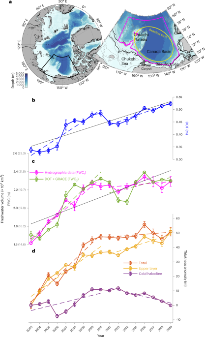
Suspicious Observers has covered this extensively, and now this is in Nature:


This could be what is causing havoc in some places around the world weather-wise: the release of melted freshwater in the Arctic Circle southwards, thus impacting the Atlantic Meridional Overturning Circulation, thus disrupting oceanic temperature plumes from the tropics towards the north that have enabled warmer weather in Europe and northern climes than would be expected for most areas at those latitudes.
 
France and other countries?... Will see how it develops.
🔴 #INFO | It looks increasingly likely that Thursday, November 2 will be a high-risk day in #France with a #storm threat for the northern and western half, all compounded by a powerful jet stream conducive to the formation of a "weather bomb". To be monitored and confirmed! ⚠ #meteo #automne
 
The next storm, Pilar, has an erratic trajectory due to the interaction with a cold front that is blocking its path to Mexico. Torrential rains are expected in the region and risk of overflowing rivers.
Tropical Depression #19E has formed in the eastern Pacific south of Guatemala. Possible tropical storm impacts for El Salvador and Guatemala in the coming days from the meandering system.

● Europe
This is getting serious. Global models are starting to converge on a powerful hurricane-force bomb cyclone impacting parts of western Europe mid next week. Details will certainly change but definitely one to watch.

● Paraguay
Massive floods due to thunderstorm in the Luque of Paraguay 🇵🇾 (28.10.2023)

● Brazil
Awful flooding in Paraná in Brazil. This is a chicken farm 😩😭
 
France and other countries?... Will see how it develops.
Major wind storms for the next six days or more will pummel the country and its European neighbors.


According to Nahel Belgherze ( @WxNB), weather models are converging towards the appearance of a “weather bomb” (equivalent to hurricane cat. 1) in Western Europe next week. France would be concerned.


Back
Top Bottom