Earthquakes around the world

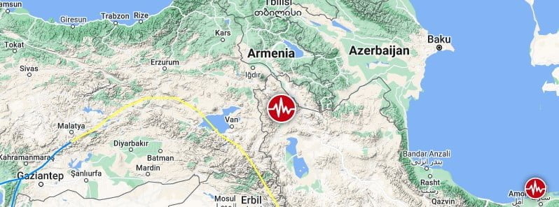
Strong and deep earthquake again in Izu Islands, Japan region. 352 km (219 mi) NW of Futami (pop: 897) Philippine Sea, Japan, on Monday, Jan 16, 2023 at 1:49 local time

Fluctuation over the Bonin Islands appeared 5 days ago.

● Update

● Earthquake Forecast: Potential for stronger seismic activity in or near the purple band 1-2 days. This is an estimate. Other regions are not excluded. SSGEOS

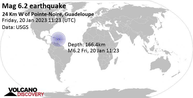
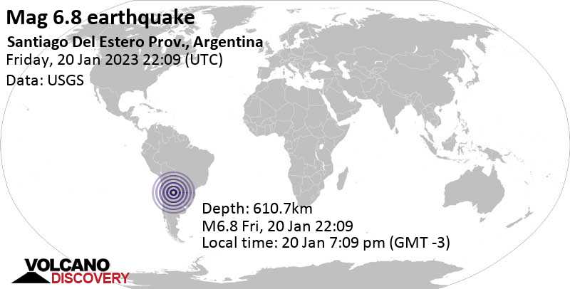
Warning of possible strong seismic activity on the west coast of Canada, U.S. and Mexico

Analysis revealed that both great earthquakes had planetary conjunctions associated with them. In all cases, Mercury, Venus, Mars and one or more outer planets were involved.

The specific geometry between celestial bodies that is associated with larger earthquakes is generally referred to as "critical planetary geometry" and "critical lunar geometry" if the Moon is involved. However, critical geometry does not always result in larger earthquakes. Sometimes only some seismic increase is observed, up to about magnitude 6.0. Sometimes there seems to be no seismic increase at all. From this we conclude that the key is the condition of Earth's crust, i.e. the amount of stress between tectonic plates and whether or not a fault section has reached its strain budget. This would logically indicate a direct relationship between the build-up of stress in Earth's crust and electromagnetic charge from critical planetary geometry.

Based on our research, it appears that gravity is not responsible for larger earthquakes at the time of critical planetary and lunar geometry. The most likely force acting on Earth's crust at the time of critical geometry is electromagnetic. This could also explain the lightning in Earth's atmosphere prior to larger earthquakes, which could be the result of atmospheric forcing induced by electromagnetic charge from critical geometry between celestial bodies in the Solar System. Solar System Geometry Survey
 
WORLDWIDE EARTHQUAKE REPORT JANUARY 16/2023

● M 5.2 - 22 km NNE of Sabang Indan, Philippines
2023-01-16 21:57:38 (UTC)
14.410°N 122.996°E. 10.0 km depth
USGS earthquake alert
A magnitude 5.2 earthquake 27 km (17 mi) ENE of Paracale (Camarines Norte) (pop: 8,290) and 33 km (21 mi) N of Daet (pop: 78,100) Philippines. The earthquake occurred at a shallow depth of 10 km beneath the epicenter early morning on Tuesday, January 17th, 2023, at 5:57 am local time. Isarog is the nearest volcano located at 93 km from epicenter.

● M 5.0 - 3 km S of Zapotitlán, Guatemala
2023-01-16 04:47:12 (UTC)
14.108°N 89.831°W. 7.8 km depth
USGS earthquake alert
A magnitude 5.0 earthquake 4 km (2 mi) S of Zapotitlan (Jutiapa) (pop: 1,620) and 21 km (13 mi) N of Ahuachapan (Ahuachapán, El Salvador) (pop: 34,100) The earthquake occurred at a very shallow depth of 7.8 km beneath the epicenter late at night on Sunday, January 15th, 2023, at 10:47 pm local time. Cerro Singüil is the nearest volcano located at 21 km from epicenter.

● M 5.0 - 81 km NNE of Calama, Chile
2023-01-16 07:50:32 (UTC)
21.806°S 68.556°W. 80.8 km depth
USGS earthquake alert
An earthquake of magnitude 5.0 occurred 82 km northeast of Calama, Chile. The quake hit at an intermediate depth of 80.8 km beneath the epicenter near Calama, Provincia de El Loa, Antofagasta, Chile, early morning on Monday, January 16th, 2023, at 4:50 am local time. San Pedro is the nearest volcano located at 18 km from epicenter

● M 5.0 - Salta, Argentina
2023-01-16 15:47:39 (UTC)
24.481°S 67.046°W. 158.5 km depth
USGS earthquake alert
A earthquake magnitude 5.0 79 km (49 mi) WSW of San Antonio de los Cobres (pop: 4,000) and 169 km (105 mi) W of Salta (pop: 512,700) Argentina. The earthquake occurred at intermediate depth of 162 km beneath the epicenter around noon on Monday, January 16th, 2023, at 12:47 pm local time. Aracar is the nearest volcano located at 78 km from epicenter.

● Earthquake Forecast: From 13 to 16 January obvious atmospheric fluctuations over the East Pacific seem to indicate Central and North America and to a lesser degree South America as critical areas, at least in the next 6 days. (5 minutes video)

● Summary

Seismic activity level has been at moderate levels in the last 24 hours. This is the last chart posted by Volcanodiscovery at 00:30 UTC on January 16 Global seismic activity level chart
~1 quake above magnitude 6
~4 quakes between magnitude 5 and 6
~34 quakes between magnitude 4 and 5
~96 quakes between magnitude 3 and 4
~305 quakes between magnitude 2 and 3
~482 quakes below magnitude 2 that people normally don't feel.
~922 earthquakes in the past 24h (839 earthquakes in the 24 hours prior to this report) 47757 tons of TNT or 3 atomic bombs
Volcanodiscovery earthquake report 24h
 
WORLDWIDE EARTHQUAKE REPORT JANUARY 17/2023


M 6.0 - Sulawesi, Indonesia
2023-01-18 00:34:44 (UTC)
0.001°S 123.183°E. 152.5 km depth
USGS earthquake alert
An earthquake of magnitude 6.0 occurred 61 km (38 mi) SSE of Gorontalo (pop: 144,200) , Indonesia. The quake hit at an intermediate depth of 152 km beneath the epicenter near Gorontalo, Indonesia, in the morning on Wednesday, January 18th, 2023, at 8:34 am local time.

● M 5.1 - 40 km SSW of Popondetta, Papua New Guinea
2023-01-17 21:42:33 (UTC)
9.091°S 148.075°E. 9.9 km depth
USGS earthquake alert

● M 5.1 - Tonga region
2023-01-17 20:46:36 (UTC)
17.740°S 171.069°W. 15.6 km depth
USGS earthquake alert

● M 5.1 - Azores Islands region
2023-01-17 17:40:58 (UTC)
42.140°N 29.262°W. 10.0 km depth
USGS earthquake alert

● M 5.1 - 96 km SSW of Dampit, Indonesia
2023-01-17 04:36:12 (UTC)
9.050°S 112.522°E. 67.0 km depth
USGS earthquake alert

● M 4.3 - Acre, Brazil
2023-01-17 09:59:25 (UTC)
8.144°S 71.338°W. 635.5 km depth
USGS earthquake alert
Very deep earthquake magnitude 4.3 - 63 km west of Tarauaca (pop.16,500) Acre, Brazil, on Tuesday, Jan 17, 2023 at 4:59 am local time

● M 4.2 - 103 km SSW of Żurrieq, Malta
2023-01-17 19:42:35 (UTC)
34.913°N 14.248°E. 10.2 km depth
USGS earthquake alert
Moderate magnitude 4.2 earthquake - Eastern Mediterranean, 111 km south of Birkirkara, Malta, on Tuesday, Jan 17, 2023 at 8:42 pm local time


● Summary

Seismic activity level has been at moderate levels in the last 24 hours. This is the last chart posted by Volcanodiscovery at 02:20 UTC on January 18 Global seismic activity level chart
~1 quake above magnitude 6
~4 quakes between magnitude 5 and 6
~37 quakes between magnitude 4 and 5
~98 quakes between magnitude 3 and 4
~281 quakes between magnitude 2 and 3
~372 quakes below magnitude 2 that people normally don't feel.
~793 earthquakes in the past 24h (922 earthquakes in the 24 hours prior to this report) 27248 tons of TNT or 1.7 atomic bombs.
Volcanodiscovery earthquake report 24h
 

The epicentre of the tremor was located 150 kilometres (93 miles) northwest of the eastern Indonesian island of Halmahera, at a depth of 48 kilometres.

There were no immediate reports of casualties or major damage.

The quake occurred around 13:06pm local time (0606 GMT) off the coast of Sulawesi island, shaking nearby islands and forcing residents to flee in panic.

"The quake was felt around 15-20 seconds. The shakings were quite long," an AFP journalist on Morotai island in the Maluku archipelago said.

"Some people went outside because they were afraid of buildings collapsing."

The NWS Pacific Tsunami Warning Center in Hawaii said in its updated warning after the quake that the tsunami threat had passed.

It said earlier tsunami waves could hit coastal areas around 300 kilometres from the epicentre.

The quake was also revised down from an initial magnitude of 7.2 reported by the USGS.

Indonesia's Meteorology, Climatology and Geophysics Agency (BMKG), which gave the magnitude at 7.1, warned of possible aftershocks.

Daryono, the head of the agency's earthquake and tsunami centre who like many Indonesians goes by one name, said the tremor was followed by five aftershocks, the largest with a magnitude of 5.3.

Second January quake

A powerful quake hit deep under the ocean in eastern Indonesia earlier this month, rattling nearby islands and damaging homes and schools.

The 7.6-magnitude quake caused roofs and walls to collapse in homes on the worst-hit island of Tanimbar Islands in the Maluku archipelago.

Indonesia experiences frequent seismic and volcanic activity due to its position on the Pacific "Ring of Fire", where tectonic plates collide.

On November 21, a 5.6-magnitude quake hit West Java province on Indonesia's main island of Java, killing 602 people.

Most of the victims were killed when buildings collapsed or in landslides triggered by the quake.

A 2018 quake and resulting tsunami on Sulawesi island killed more than 4,000 people.

A major earthquake off Sumatra on December 26, 2004, set off an Indian Ocean tsunami that killed more than 230,000 people as far away as Sri Lanka, India and Thailand.

That powerful 9.1-magnitude quake triggered 100-foot waves that hit the shore of Banda Aceh on Sumatra.


Cascadia tremor increase.. Northern California.. West Coast update. Tuesday night 1/17/2023
Jan 18, 2023 TheEarthMaster

Update Graph of the Seismic data:
 
Seismic activity increase

M 5.8 - Turkey-Iran border region
2023-01-18 10:08:12 (UTC)
38.411°N 44.935°E. 10.0 km depth
USGS earthquake alert

Significant M5.8 earthquake hits northern Iran​


A strong and shallow earthquake registered by the USGS as M5.8 hit the Turkey-Iran border region at 10:08 UTC on January 18, 2023. The agency is reporting a depth of 10 km (6.2 miles). EMSC is reporting M5.6 at a depth of 2 km (1.2 miles).

The epicenter was located 15.5 km (9.6 miles) S of Khowy (population 175 370), 28 km (17.4 miles) NNE of Salmās (population 81 606), 54 km (33.5 miles) S of Qarah Ẕīā’ od Dīn (population 31 937), 73.2 km (45.5 mi) W of Marand (population 123 191) and 96.3 km (59.8 miles) N of Orūmīyeh (population 577 307), West Azerbaijan, Iran.

30 000 people are estimated to have felt very strong shaking, 293 000 strong, 215 000 moderate and 2 981 000 light.

The USGS issued a Yellow alert for shaking-related fatalities and economic losses. Some casualties and damage are possible and the impact should be relatively localized. Past yellow alerts have required a local or regional-level response.

 
Mediterranean Sea: Lybian Sea / Malta
18 Jan 2023 • M 4.7

I just got a notification from my "terremoto" app (ital. for earthquake), showing a third M4.7 earthquake occurred today at a depth of 38 km. Two others appeared at 29 km depth (at 05:21) and another at 20 km depth (at 09:46), both M 4.7, as well.

2023-01-18-15-12.jpg
 
This M4.7 was the second earthquake in the Mediterranean region,

Mediterranean Sea: Lybian Sea / Malta
18 Jan 2023 • M 4.7

I just got a notification from my "terremoto" app (ital. for earthquake), showing a third M4.7
Almost 24 hours ago:
● M 4.2 - 103 km SSW of Żurrieq, Malta
2023-01-17 19:42:35 (UTC)
34.913°N 14.248°E. 10.2 km depth
USGS earthquake alert
Moderate magnitude 4.2 earthquake - Eastern Mediterranean, 111 km south of Birkirkara, Malta, on Tuesday, Jan 17, 2023 at 8:42 pm local time

The earthquake M4.7 on January 18 was updated to magnitude 5.0 by USGS

M 5.0 - 96 km SSW of Żurrieq, Malta
2023-01-18 04:21:58 (UTC)
34.986°N 14.244°E. 10.0 km depth
USGS earthquake alert

Third earthquake >M4.0 People in the Malta area, be alert.

M 5.1 - 107 km S of Żurrieq, Malta
2023-01-18 15:54:46 (UTC)
34.870°N 14.328°E. 10.0 km depth
USGS earthquake alert
 
WORLDWIDE EARTHQUAKE REPORT JANUARY 18/2023

Seismic activity in Indonesia increased on January 18. Six aftershocks of magnitude greater than 4.0 were recorded from the M7.0 earthquake in the Molucca Sea Indonesia. The highest magnitude earthquake was 5.5.

M 5.5 - 143 km NW of Tobelo, Indonesia
2023-01-18 08:01:26 (UTC)
2.682°N 127.135°E. 50.8 km depth
USGS earthquake alert
chrome_screenshot_1674091827213.png

M 4.6 - 161 km NW of Tobelo, Indonesia
M 4.6 - 159 km NW of Tobelo, Indonesia
M 4.4 - 49 km W of Manokwari, Indonesia

M 5.0 - south of Java, Indonesia
2023-01-18 16:10:45 (UTC)
11.107°S 111.787°E. 10.0 km depth
USGS earthquake alert

M 5.1 - south of Java, Indonesia
2023-01-18 16:27:48 (UTC)
11.129°S 111.691°E. 10.0 km depth
USGS earthquake alert

● M 5.0 - Mid-Indian Ridge
2023-01-18 11:06:53 (UTC)
13.393°S 66.819°E. 10.0 km depth
USGS earthquake alert

● M 4.7 - 102 km SSW of Żurrieq, Malta
2023-01-18 17:00:12 (UTC)
34.936°N 14.199°E. 10.0 km depth
USGS earthquake alert
A fourth earthquake in the Mediterranean region of Malta. Moderate mag. 4.7 earthquake, Eastern Mediterranean, 103 km (64 mi) SSW of Żurrieq (pop: 9,150), Malta, on Wednesday, Jan 18, 2023 at 6:00 pm

● M 4.2 - 1 km NNW of Áno Kastrítsi, Greece
2023-01-18 18:22:50 (UTC)
38.288°N 21.831°E. 10.0 km depth
USGS earthquake alert
Light magnitude 4.2 earthquake 10.5 km north of Patras, Achaea, Western Greece, on Wednesday, Jan 18, 2023 at 8:22 pm local time.

● Earthquake Forecast: Critical planetary geometry from 19 to 22 January may cause a seismic increase, potentially reaching high 7 to 8 magnitude. Current atmospheric indicators seem to point to the Americas for an initial seismic increase, most likely 20-22 January.

● Summary

Seismic activity level has been at very high levels in the last 24 hours. This is the last chart posted by Volcanodiscovery at 00:30 UTC on January 18 Global seismic activity level chart
~1 quake above magnitude 7
~8 quakes between magnitude 5 and 6
~61 quakes between magnitude 4 and 5
~145 quakes between magnitude 3 and 4
~265 quakes between magnitude 2 and 3
~427 quakes below magnitude 2 that people normally don't feel.
~906 earthquakes in the past 24h (793 earthquakes in the 24 hours prior to this report) 825 gigawatt hours, equivalent to 7.1 x 10⁵ tons of TNT or 44.4 atomic bombs
Volcanodiscovery earthquake report 24h
 
WORLDWIDE EARTHQUAKE REPORT JANUARY 19/2023

A fourth earthquake in the Mediterranean region of Malta. Moderate mag. 4.7 earthquake, Eastern Mediterranean, 103 km (64 mi) SSW of Żurrieq (pop: 9,150), Malta, on Wednesday, Jan 18, 2023 at 6:00 pm
Seismic activity continues in this eastern Mediterranean region. Significant earthquakes occurred today in Greece and Libya.

● M 5.0 - 32 km WNW of Míthymna, Greece
2023-01-19 02:22:27 (UTC)
39.502°N 25.836°E. 10.0 km depth
USGS earthquake alert
A magnitude 5.0 earthquake 30 km (18 mi) WNW of Molivos (pop: 1,560) Greece and 56 km (35 mi) SW of Ezine (Camikebir, Turkey) (pop: 15,700) The earthquake occurred at a shallow depth of 10 km beneath the epicenter early morning on Thursday, January 19th, 2023, at 4:22 am local time.

● M 4.0 - 74 km E of Darnah, Libya
2023-01-20 00:29:25 (UTC)
32.695°N 23.423°E. 10.0 km depth
USGS earthquake alert
Moderate magnitude 4.0 earthquake - Eastern Mediterranean, 74 km east of Darnah (78,800) Libya. The earthquake occurred at a shallow depth of 10 km beneath the epicenter early morning on Friday January 20th, 2023, at 02:29 am local time.

● M 5.1 - 47 km ENE of Pārūn, Afghanistan
2023-01-19 11:30:42 (UTC)
35.541°N 71.424°E. 96.0 km depth
USGS earthquake alert
An earthquake of magnitude 5.1 occurred 47 km (29 mi) ENE of Pārūn (Wama) (pop: 1000) and 78 km northeast of Assad-Abad (pop. 48,400) Afghanistan, the quake hit at an intermediate depth of 96 km beneath the epicenter near Assad-Abad, early afternoon on Thursday, January 19th, 2023, at 3:30 pm local time.

● M 5.0 - 32 km NE of Yigo Village, Guam
2023-01-19 13:01:08 (UTC)
13.745°N 145.096°E. 120.9 km depth
USGS earthquake alert

● M 4.1 - El Salvador
2023-01-19 18:26:16 (UTC)
13.841°N 89.952°W. 7.1 km depth
USGS earthquake alert
An earthquake magnitude 4.1 occurred 28 km (17 mi) WNW of Sonsonate (pop: 59,500) El Salvador. The earthquake occurred at a shallow depth of 7 km beneath the epicenter on Thursday January 19th, 2023, at 12:26 pm local time.

Seismic activity in Indonesia increased on January 18. Six aftershocks of magnitude greater than 4.0 were recorded from the M7.0 earthquake in the Molucca Sea Indonesia. The highest magnitude earthquake was 5.5.
Aftershocks continue after 7.0 magnitude earthquake in Indonesia

~M 4.5 - 155 km NW of Tobelo, Indonesia
~M 4.5 - 163 km NW of Tobelo, Indonesia
~M 4.8 - 154 km NW of Tobelo, Indonesia
~M 4.7 - 152 km NW of Tobelo, Indonesia

Earthquake Forecast update: Potential for stronger seismic activity in or near the purple band 1-6 days (most likely 23-24 January). This is an estimate. Other regions are not excluded. SSGEOS
20230119_195233.jpg

● Summary

Seismic activity level has been at moderate levels in the last 24 hours. This is the last chart posted by Volcanodiscovery at 01:00 UTC on January 20 Global seismic activity level chart
~3 quakes above magnitude 5
~39 quakes between magnitude 4 and 5
~131 quakes between magnitude 3 and 4
~228 quakes between magnitude 2 and 3
~465 quakes below magnitude 2 that people normally don't feel.
~866 earthquakes in the past 24h (906 earthquakes in the 24 hours prior to this report) Estimated combined seismic energy release 5259 tons of TNT or 0.3 atomic bombs.
Volcanodiscovery earthquake report 24h
 
Guadeloupe was shaken 41 km (25 mi) WSW of Pointe-Noire (pop: 7,750) Guadeloupe, by an earthquake of magnitude 6.2 the quake hit at a considerable depth of 165.3 km beneath the epicenter near Pointe-Noire, Guadeloupe, in the morning on Friday, January 20th, 2023, at 7:23 am local time.
Nearest volcano: Soufrière de Guadeloupe (53 km / 33 mi)
West Indies, France, 16.05°N / -61.67°W
Current status: restless
Last update: 2 Mar 2022 (seismic swarm)
chrome_screenshot_1674216348116.png

M 6.2 - 40 km WSW of Pointe-Noire, Guadeloupe
2023-01-20 11:23:41 (UTC)
16.131°N 62.156°W. 166.4 km depth
USGS earthquake alert

Data for the same earthquake reported by different agencies

Mag.DepthLocationSource
6.2166 km24 Km W of Pointe-Noire, GuadeloupeUSGS
6.2165 kmGUADELOUPE REGION, LEEWARD ISL.EMSC
6.1163 kmGuadeloupe: Leeward IslandsGFZ
6.2166 kmGuadeloupe: Leeward IslandsRaspberry
Shake
6.210 kmGuadeloupe: Leeward IslandsIRIS
5.8166 kmGuadeloupe: Near Petit-BourgRENASS
6.2165 kmGuadeloupe-Martinique [Sea]INGV
6.2169 kmGuadeloupe: Leeward IslandsGeoAu

 
An earthquake of magnitude 6.8 occurred early evening on Friday, January 20th, 2023, at 7:09 pm local time 24 km (15 mi) SW of Campo Gallo (Alberdi) (pop: 5,460) Argentina. According to preliminary data, the quake was located at a great depth of 610.7 km
M 6.8 - 24 km SW of Campo Gallo, Argentina
2023-01-20 22:09:39 (UTC)
26.721°S 63.039°W. 610.7 km depth
USGS earthquake alert

Data for the same earthquake reported by different agencies

Mag.DepthLocationSource
6.8611 kmSantiago Del Estero Prov., ArgentinaUSGS
6.8586 kmSANTIAGO DEL ESTERO, ARGENTINAEMSC
6.8611 kmSantiago Del Estero Prov., ArgentinaRaspberry
Shake
6.2514 kmArgentina: Near TucumánRENASS
6.7587 kmSantiago Del Estero, ArgentinaGFZ
6.810 kmArgentina: Santiago Del Estero Prov., Arg.IRIS
6.6596 kmSantiago Del Estero Province, Argentina [Land: Argentina]INGV
6.8582 kmSantiago Del Estero Prov., ArgentinaGeoAu
 
WORLDWIDE EARTHQUAKE REPORT JANUARY 20/2023

● Earthquake Forecast: Critical planetary geometry from 19 to 22 January may cause a seismic increase, potentially reaching high 7 to 8 magnitude. Current atmospheric indicators seem to point to the Americas for an initial seismic increase, most likely 20-22 January.
IMG_20230120_184029_271.jpg

It can be said that the earthquakes in Guadeloupe (M6.2) and Argentina (M6.8) confirmed the SSGEOS forecast according to electromagnetic fluctuations. Will the seismic activity in California in the last 24 hours be indicative of a major earthquake? We will have to wait and see for a few more days.

M 3.6 - 9km SW of Cloverdale, CA
M 2.9 - 1km SE of Portola Valley, CA
M 2.6 - 2km N of Woodside, CA
M 3.1 - 8km NNW of New Idria, CA
M 4.3 - 16km WSW of Weitchpec, CA
M 2.9 - 1km ESE of Portola Valley, CA

Puerto Rico and Mexico are other regions that should be on alert.

M 3.4 - 131 km N of San Juan, Puerto Rico
M 2.9 - 9 km WNW of Pole Ojea, Puerto Rico
M 2.5 - 0 km N of Magas Arriba, Puerto Rico
M 3.1 - 16 km WNW of Rincón, Puerto Rico
M 3.2 - 35 km N of Hatillo, Puerto Rico
M 2.9 - 42 km NNW of San Antonio, Puerto Rico
M 4.0 - 118 km N of Suárez, Puerto Rico

● M 5.0 - near the east coast of Honshu, Japan
2023-01-20 05:48:28 (UTC)
38.926°N 142.092°E. 48.8 km depth
USGS earthquake alert

● M 5.4 - Kermadec Islands region
2023-01-20 12:41:15 (UTC)
28.144°S 176.277°W. 10.0 km depth
USGS earthquake alert

● M 5.0 - 162 km NW of Tobelo, Indonesia
2023-01-20 17:49:34 (UTC)
2.802°N 127.012°E. 22.7 km depth
USGS earthquake alert

● Summary

Seismic activity level has been at high levels in the last 24 hours. This is the last chart posted by Volcanodiscovery at 00:30 UTC on January 21 Global seismic activity level chart
~2 quakes above magnitude 6
~3 quakes between magnitude 5 and 6
~33 quakes between magnitude 4 and 5
~105 quakes between magnitude 3 and 4
~228 quakes between magnitude 2 and 3
~412 quakes below magnitude 2 that people normally don't feel.
~783 earthquakes in the past 24h (866 earthquakes in the 24 hours prior to this report) Estimated combined seismic energy release: 319 gigawatt hours, equivalent to 2.7 x 10⁵ tons of TNT or 17.1 atomic bombs.
Volcanodiscovery earthquake report 24h
 
Earthquake swarm on the San Andreas fault. San Francisco Bay California. Friday 1/20/2023
German Session 21 June 2014

(Mikey) I made a calculation about the magnetic field of the earth today. In just six months in 2014, the magnetic field weakened by 10% in North America. It weakened 6 microtesla, and the average magnetic field is 60 microtesla. And ONLY over North America. In Russia and China, it appeared to have grown a little bit stronger.

(L) So it's weakening mainly over North America? Is there any significance to that?


A: Oh indeed!

Q: (L) And what might that significance be?

A: Just you wait!

Q: (Joe) Does a weakened magnetic field have any correlation to stronger likelihood of meteorite impacts or space rock attraction type stuff?

A: Or geological activity!
 
Back
Top Bottom