Earthquakes around the world

▪ Water levels in Florida wells changed briefly after Tuesday's earthquake in the Gulf of Alaska.
▪ Seismic waves traveling through the earth often cause groundwater changes after earthquakes.

Something Shocking Happened in Florida After the Alaska Earthquake: Well Water Levels Changed Jan. 24, 2018
https://weather.com/news/news/2018-01-24-alaska-earthquake-florida-wells-shaking

Tuesday's 7.9 magnitude earthquake in the Gulf of Alaska sent vibrations through the earth that caused water to rise and fall in wells in Florida, thousands of miles away.

Sensors near Fort Lauderdale and Madison, near the Georgia border, showed a minor change in water levels after the earthquake, according to the United States Geological Survey (USGS).

A water level rise from 41.59 feet to 41.77 feet was recorded at the well near Madison before it returned to normal. At the well near Fort Lauderdale, the water level fell from 1.42 feet to 1.31 feet.

Why did water levels in these wells some 3,800 miles away from the earthquake's epicenter change?

Vibrations that move through the earth called seismic waves are the culprit. Seismic waves are depicted by the upward and downward lines on seismographs used to detect earthquakes around the world.

"Water levels in wells respond to the seismic-wave induced expansion and contraction of the aquifer tapped by the well, in turn causing step or oscillatory fluid-pressure changes," the USGS says.

The changes in groundwater levels are often seen hundreds, or even thousands, of miles away from an earthquake's epicenter.

After an 8.5 magnitude earthquake near Alaska in 1964 water level changes were reported at 716 wells in the United States, according to the USGS.

Occasionally, changes can be extreme.

A 5.2 magnitude northwest Pennsylvania temblor in 1998 rendered dry about 120 wells for local homes for about three months.

The Denali, Alaska, 7.9 magnitude earthquake of 2002 caused a well in Wisconsin to rise 2 feet.
 
Earlier today:
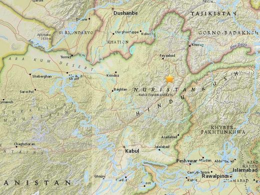
M6.1 earthquake rocks Afghanistan with tremors felt in Delhi, one killed, eight injured and with a depth of 119 miles.

afghan_quake.jpg


And January 6th 2018: 5.1-magnitude earthquake rocks western Iran in same area as deadly November 2017 quake

In November 2017: Iran-Iraq border region hit with 7.2 magnitude earthquake, 400+ killed, deadliest quake of 2017 (UPDATE)

And just now:
M 5.7 - 47km SE of Pedasi, Panama
2018-01-27 21:45:12 UTC 7.274°N 79.686°W 10.0 km depth

us2000cqgn_ciim_geo.jpg

Just a few days ago, on the 27th January, there was another in Panama registering 5.7,

Of note was the super-blood-blue-moon-eclipse ;) which happened this morning.
 
Powerful Earthquake Hits Taiwan - USGS 04.02.2018
https://sputniknews.com/asia/201802041061346486-taiwan-earthqauke/

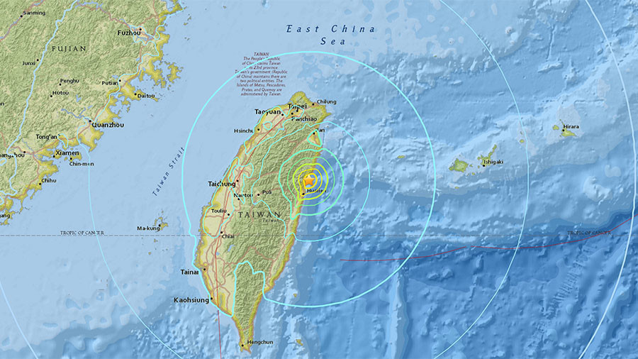
The US Geological Survey reported of a strong 6.1 magnitude earthquake striking Taiwan's east coast 17 km (10 miles) northeast of Hua-lien.

The agency stated the quake took place at a depth of 7.8 km.

However, according to information from the China Earthquake Networks Center, the tremors were of lesser magnitude — about 5.6.

No tsunami warning has been issued so far, as well as no information about possible casualties or damages reported.
 
angelburst29 said:
Powerful Earthquake Hits Taiwan - USGS 04.02.2018
https://sputniknews.com/asia/201802041061346486-taiwan-earthqauke/

The US Geological Survey reported of a strong 6.1 magnitude earthquake striking Taiwan's east coast 17 km (10 miles) northeast of Hua-lien.

The agency stated the quake took place at a depth of 7.8 km.

However, according to information from the China Earthquake Networks Center, the tremors were of lesser magnitude — about 5.6.

No tsunami warning has been issued so far, as well as no information about possible casualties or damages reported.

Another in east Taiwan:
Shallow M6.4 earthquake causes hotel to collapse in east Taiwan (PHOTO, VIDEO)

DVXXmlHU0AAqtKP.jpg


The epicenter of the quake was reportedly just 1km deep

5a79d751dda4c86f7d8b463d.jpg


Earlier on Tuesday, a magnitude 4.7 earthquake hit Hualien County. That quake followed a 5.3-magnitude earthquake that struck Taiwan on Sunday night, causing 80 aftershocks as of Tuesday afternoon -
 
itellsya said:
The number of injured in a powerful earthquake in eastern Taiwan on Tuesday has increased from 114 to 188 people, China's CGTN television reported.

Number of Injured in Taiwan Quake Rises to 188
https://sputniknews.com/environment/201802061061417994-taiwan-quake-injured-rising/

The US Geological Survey earlier reported that a 6.4-magnitude earthquake occurred about 22 kilometers (14 miles) northeast of the city of Hualien at the depth of 11 kilometers at about 23:50 local time (15:50 GMT).

According to CGTN, underground shocks caused serious damages to infrastructure, with at least five buildings partially or completely destroyed in Hualien, including a hotel. The latest reports indicate that a large number of guests were trapped in the hotel building, some 116 guests have already been evacuated.

The tremors also caused disruptions in the transport and energy supply systems, with more than 560 houses left without electricity. The search and rescue operation, involving military personnel, firefighters, rescuers, doctors and specially trained police dogs, continues, the CGTN reported.

The earthquake is the second one in the area in several days, the previous 6.6-magnitude quake has struck the east coast just adozen miles (17km) off Hualien.
 
The new tremors were registered after the earthquake on Tuesday killed six and injured up to 256 people.

5.7 Magnitude Quake Hits off Taiwan's Coast Day After Deadly Strike 07.02.2018
https://sputniknews.com/asia/201802071061444317-taiwan-quake-new/

The US Geological Survey reported that the 5.7 magnitude quake hit off Taiwan's coast. The tremors were registered at 11:21 PM on Wednesday in the water area near the Hualien County, where the previous quake occurred. The epicenter of the earthquake was at a depth of 12 kilometers, according to China Earthquake Networks Center (CENC).

The previous quake hit the northeast of the island on Tuesday, resulting in six people being killed, 260 injuries and 67 going missing. The epicenter of the deadly quake was at a depth of 11 kilometers.
 
From USGS
M 5.8 - 37km SSW of San Patricio, Mexico (Jalisco's coast)
2018-02-09 14:05:47 (UTC)
18.889°N 104.775°W
Depth 10.0 km

previous, there were others according to national seismologic service _http://www2.ssn.unam.mx:8080/catalogo/

4.5 - 65 km al SUROESTE de CIHUATLAN, JAL
2018-02-09
07:56:2718.76°, -104.92°
16 km

3.5 - 18 km al NORESTE de CIHUATLAN, JAL

2018-02-09
06:31:14
19.36°, -104.45°
64 km

4.0 - 111 km al SUROESTE de CIHUATLAN, JAL
2018-02-09
05:54:20
8.95°, -105.57°
16 km

Not tsunami warning issued

A well known area to have strong earthquakes, and again with the same day, at least it was in another month, though... the 1995 Colima–Jalisco earthquake of 8.0
 
minutes ago another earthquake was felt in Mexico City strong but not rough, so far ...did not heard anything falling this time, do not know more ... hope everyone is fine ...
from USGS

M 7.5 - 2km SE of Pinotepa de Don Luis, Mexico (coast of Oaxaca and Chiapas)
Time
2018-02-16 23:39:44 (UTC)
Location
16.400°N 97.900°W
Depth
43.0 km
 
mabar said:
minutes ago another earthquake was felt in Mexico City strong but not rough, so far ...did not heard anything falling this time, do not know more ... hope everyone is fine ...
from USGS

M 7.5 - 2km SE of Pinotepa de Don Luis, Mexico (coast of Oaxaca and Chiapas)
Time
2018-02-16 23:39:44 (UTC)
Location
16.400°N 97.900°W
Depth
43.0 km

Yup I felt it quite strong :/ Im thinking about the buildings that had a bit of damage from the 19-S :/ Hopefully nothing major happens this time.
 
Take care Mexicans! More info and videos here:

https://www.sott.net/article/377616-7-2-magnitude-quake-strikes-Mexico-near-Pacific-coast

Going through this thread, there have been A LOT of earthquakes above 6 this year!
 
mabar said:
minutes ago another earthquake was felt in Mexico City strong but not rough, so far ...did not heard anything falling this time, do not know more ... hope everyone is fine ...
from USGS

M 7.5 - 2km SE of Pinotepa de Don Luis, Mexico (coast of Oaxaca and Chiapas)
Time
2018-02-16 23:39:44 (UTC)
Location
16.400°N 97.900°W
Depth
43.0 km

Dutchsinse has put this video up, discussing this event:
https://www.youtube.com/watch?v=0e9CPmtCxJE

It goes for over an hour, but the nitty gritty will be near the beginning of the video, and he shows some news vid from the area. I hope all the Mexican crew are OK, God Bless you guys! It was apparently up in the mountains and no large towns nearby, but the small villages would certainly have been rocking!
 
mkrnhr said:
>7 earthquakes are very strong. Hope you're all fine there.

I hope so too that everybody is fine. The pacific ring of fire is indeed very active in the last months.
 
Back
Top Bottom