Were definitely seeing some early cooling here from the side effect's of the current
LaPalma emissions. And obviously
with other derivatives at play.
I also wonder of the current
reflective property's
of the global volcanic ash is at this time.
Presently it's eleven point five degrees Celsius this morning at 06:13 on 9-27-21.
-22.8 ° C at Anaktuvuk Pass this
09/25/2021 at 693 m in the Brooks Range in
#Alaska . According to
@Alaskawx, the lowest temperature recorded in September in Alaska was -30 ° C at Lake Galbraith (east of Anaktuvuk Pass) on9/3/1992.(c)
: FAA webcam
The 35 ° C from June 12, 1977 to
#Calvi were the maximum, all stations of the main MF network combined, for the whole of the summer of 1977 in metropolitan France. 1977, a particularly cool summer. In 2021 we reach 35 ° C in Calvi on September 26 (the latest crossing)!
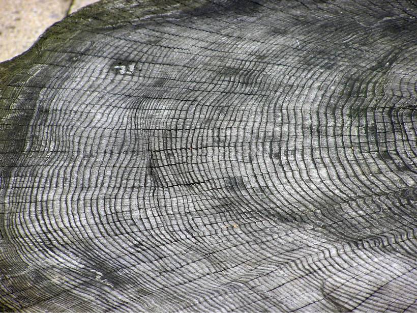
Mass spectroscopy of tree ring material indicates a sharp, single-year rise in carbon-14 concentrations consistent with an extreme solar energetic particle event that occurred around 5410 BCE.

eos.org
By Morgan Rehnberg 12 July 2021
A translation of this article was made by Wiley. 本文由Wiley提供翻译稿。
The Sun constantly emits a stream of energetic particles, some of which reach Earth. The density and energy of this stream form the basis of
space weather, which can interfere with the operation of satellites and other spacecraft. A key unresolved question in the field is the frequency with which the Sun emits bursts of energetic particles strong enough to disable or destroy space-based electronics.
One promising avenue for determining the rate of such events is the
dendrochronological record. This approach relies on the process by which a solar energetic particle (SEP) strikes the atmosphere, causing a chain reaction that results in the production of an atom of carbon-14. This atom subsequently can be incorporated into the structure of a tree; thus, the concentration of carbon-14 atoms in a tree ring can indicate the impact rate of SEPs in a given year.
To date, three events of extreme SEP production are well described in literature, occurring approximately in the years 660 BCE, 774–775 CE, and 992–993 CE. Each event was roughly an order of magnitude stronger than any measured in the space exploration era.
Miyake et al. describe such an event, which occurred between 5411 BCE and 5410 BCE. Because of this burst, atmospheric carbon-14 increased 0.6% year over year in the Northern Hemisphere and was sustained for several years before dropping to typical levels.
The authors deduced the presence of this event by using samples collected from trees in three widely dispersed locales: a bristlecone pine in California, a Scotch pine in Finland, and a European larch in Switzerland. Each sample had its individual tree rings separated, and material from each ring underwent accelerator mass spectrometry to determine its carbon-14 content.
Using statistical methods, the researchers identified a pattern of small carbon-14 fluctuations consistent with the Sun’s 11-year solar cycle; the event recorded in the tree ring occurred during a time of solar maximum. Notably, other evidence suggests that the Sun was also undergoing a decades-long period of increasing activity.
If an extreme SEP burst is indeed the cause of the additional carbon-14, then these observations could aid in forecasting future events. However, tree ring measurements cannot rule out other extraterrestrial causes, such as a nearby supernova explosion. Confirmation will require isotopic measurements of beryllium and chlorine taken from ice cores, according to the authors. (
Geophysical Research Letters,
https://doi.org/10.1029/2021GL093419, 2021)—Morgan Rehnberg, Science Writer
Citation: Rehnberg, M. (2021), Tree rings show record of newly identified extreme solar activity event, Eos, 102,
Tree Rings Show Record of Newly Identified Extreme Solar Activity Event. Published on 12 July 2021.
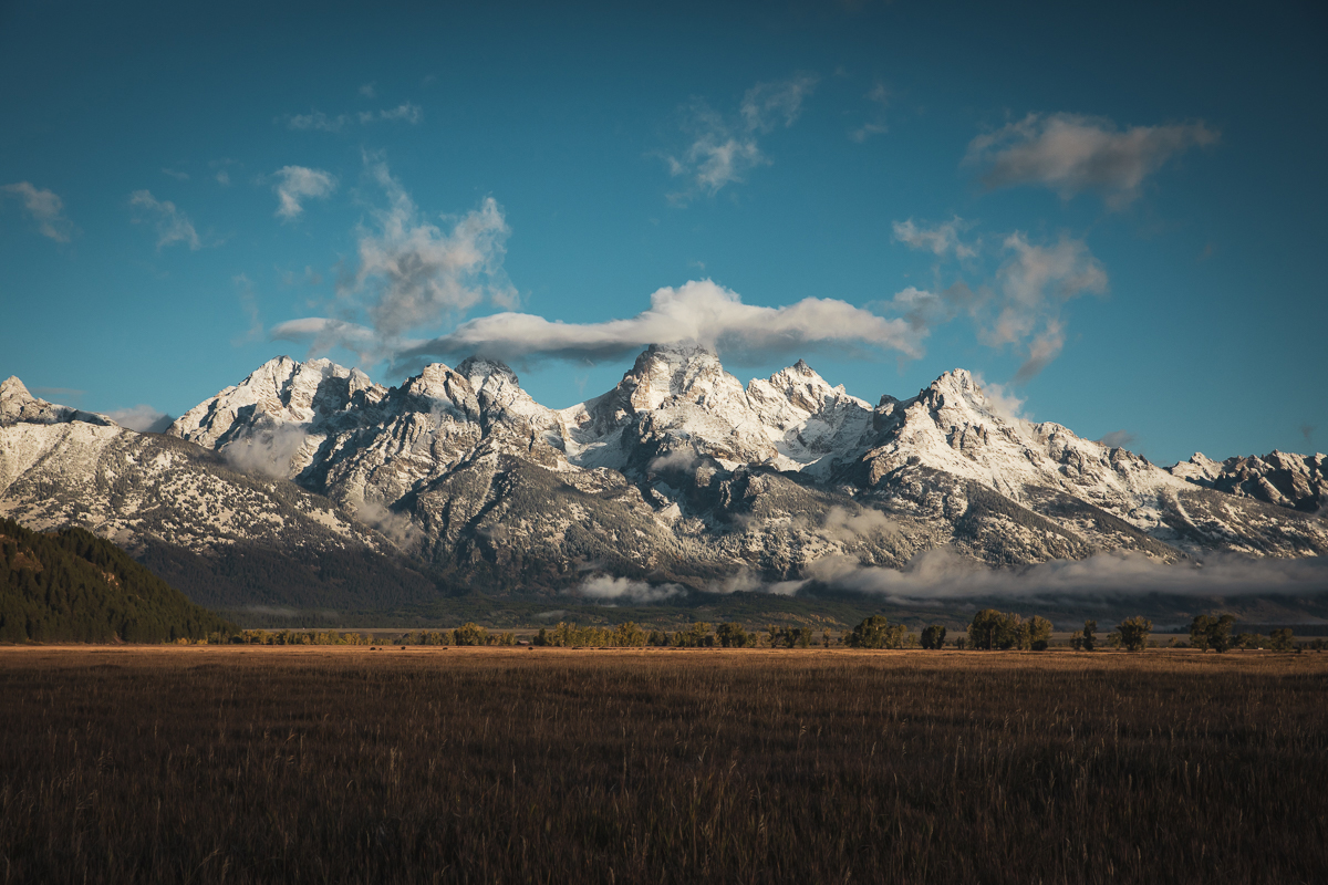
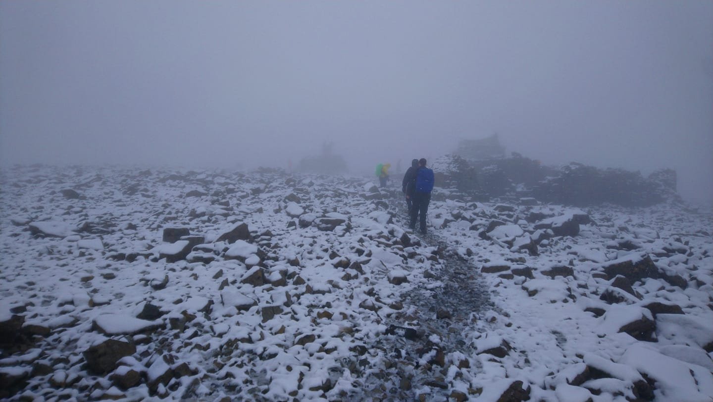
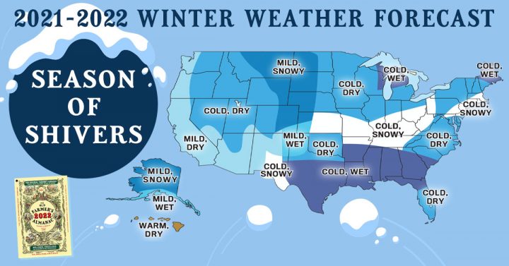
Autumn Snowfall In The Tetons
September 21 2021 / Pic's
Climate change in the Arctic linked to Texas' severe winter weather
By Lauren Fox, AccuWeather staff writer Updated Sep. 24, 2021 3:36 AM CEST
The state of Texas battled a devastating deep freeze last winter that
resulted in up to $155 billion in damages and economic loss, according to AccuWeather estimates, and a new study published in the journal
Science reveals connections between the weather disaster that occurred in Texas last year and climate change in the Arctic.
The study, which was published in early September, revealed a connection between Arctic temperatures and the Valentine's Week Freeze that inundated Texas this past February. The severe winter weather led to at least 210 fatalities,
according to the Texas Department of State Health Services.
"Clearly an extreme event like this is very unusual in a place like Texas, so it is hard for many people and policymakers to react and take the threat seriously," AccuWeather Meteorologist Brett Anderson said. "The biggest dangers people faced were a lack of heat in homes that had no backup power or heat sources."
Many homes in Texas are not properly insulated to handle the level of extreme cold that gripped Texas that week back in February. Homes were flooded when pipes burst due to the extreme cold, and some residents even had icicles form in their homes and apartment buildings, including one from Dallas, Texas, who shared a photo to social media of icicles hanging from a ceiling fan on Feb. 15.
At the worst of the historic cold snap, the temperature at Dallas-Fort Worth International Airport
bottomed out at 2 degrees below zero in the early-morning hours on Feb. 16 as Arctic air from the polar vortex rushed into the region.
The
polar vortex is a band of strong westerly winds that sits about 10-30 miles above the North Pole and traps extremely cold air. Rising temperatures in the Arctic can cause an area of strong high pressure to develop in the atmosphere surrounding the North Pole, which can "push" the polar vortex farther south, into places like North America or Europe and Asia, Anderson explained.
"Think of the strengthening high-pressure area over the polar region as an expanding balloon and a pocket of air outside the balloon as the polar vortex," Anderson said. "As the balloon fills up with air the pocket of air outside of the balloon -- the polar vortex -- gets pushed farther away, and, in this case, it is being pushed farther south into the mid-latitudes."
Judah Cohen, the lead author of the study, told AccuWeather in an interview that the research revealed that the severe weather in Texas was due to what the scientists described as a stretched polar vortex event.
Cohen explained that sometimes stretched polar vortex events can make the polar vortex appear to be the shape of a dumbbell, with one spot of energy focused in North America and another in Asia.
While the February cold snap in Texas was a memorable one, Cohen said there are many modern-day examples of stretched polar vortex events in recent memory, and that at least one event happens practically every year, although not every event reaches the caliber that the one in Texas did.
“The poster child for these types of events is the winter of 2013-14," Cohen said. “It happened repeatedly that winter. It really led to the extreme cold, especially in the Great Lakes.”
The study published in Science also provided some more insight into these polar vortex events that may leave some reason for concern because they are becoming more and more frequent. According to Cohen, the paper shows that the frequency of these events has nearly doubled since the 1980s.
"I believe there will continue to be an increasing trend in extreme events as the planet continues to warm," Anderson said. "That does not mean every year will be worse. There will be periods of more normal weather," he added, pointing out that some years will bring fewer extremes. "But the long-term trend is very likely to continue to rise."
According to Anderson, policymakers will need to get on board with climate change legislation and infrastructure, which he said, in many cases, are very outdated and need to be upgraded in order to properly prepare for more incidents like the one in Texas.
The study goes against many people's assumptions of what climate change is, Cohen explained, as it is typically associated with warm weather.
“Climate change can lead to more heat waves, more flooding events, more drought, wildfires in the West," Cohen said. "A lot of extreme weather events that we’re seeing this summer."
Pointing out what may be proving to be a misconception about climate change, Cohen said, “The assumption was that climate change can lead to milder winters, less snowfall -- it intuitively makes sense. So our study comes to this counterintuitive conclusion," Cohen continued. "This Arctic change can lead to more extreme winter weather events, like the Texas cold wave.”
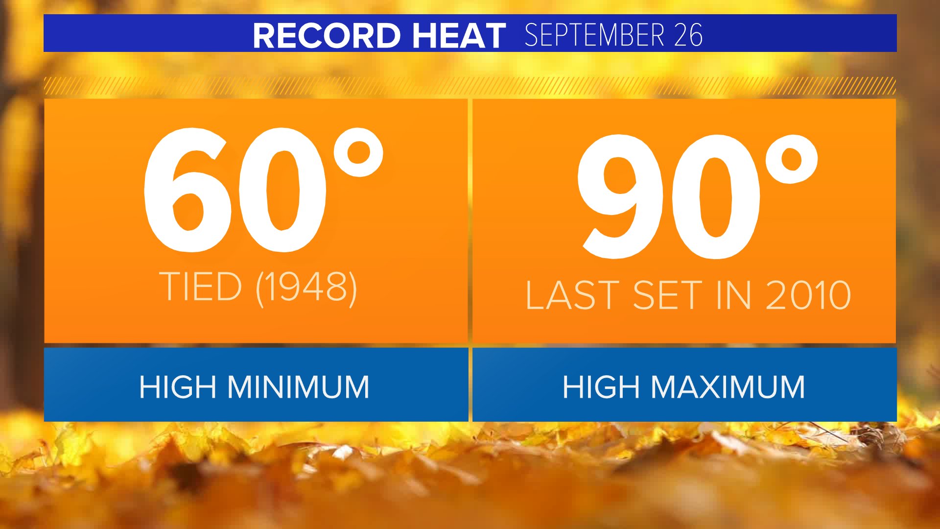
Cory Reppenhagen @CReppWx
5:07 PM · Sep 26, 2021·
Denver tied a record high minimum this morning, last set in 1948. More record heat possible later today. The high max is 90 degrees last set in 2010.
#9wx #COwx
Sunny, warm and dry to start the week...our next cold front by Wednesday

www.thedenverchannel.com
Posted at 7:35 AM, Sep 26, 2021 and last updated 5:29 PM, Sep 26, 2021 Video
This first weekend autumn has been a warm one and today will be about 10 to 12 degrees above normal. We'll see highs top out in the upper 80s during today's at-home
Broncos game.
If you're heading west to see the leaves change, you'll find highs in the 70s through the central mountains, with highs on the Western Slope.
The aspen trees will be full-on gold over the central and northern mountains and nearing their peak over the southern mountain areas.
This warm weather will continue into the first of next week.
We'll see 80s on Monday and Tuesday.
Our next cold front will usher in some cool and wet weather starting Wednesday.