XPan
The Living Force
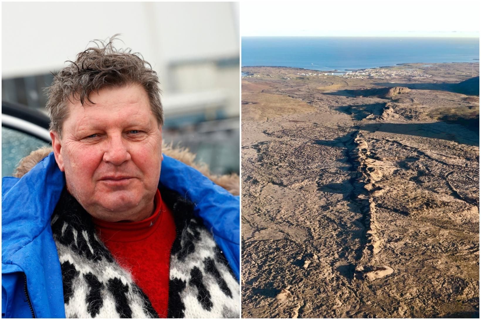
Grindavík, Iceland
(10-)11 Nov 2023 - 03:06 local Icelandic time
mbl.is also confirms that the town of Grindavík is being evacuated now. From the geological video i've heard that 3500 people live in that town. Here the article as follow:

 www.mbl.is
Víðir Reynisson, Chief Inspector of Public Security, says in an interview with mbl.is that the decision was made following the advice of scientists.
"Then it took no time to make this decision and implement it," says Víðir.

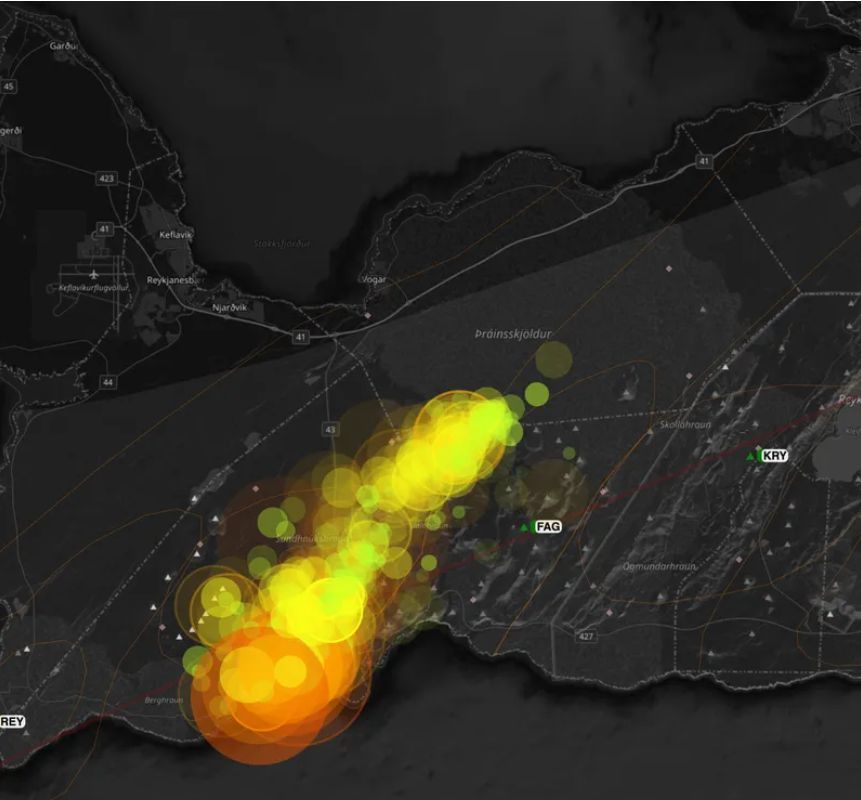
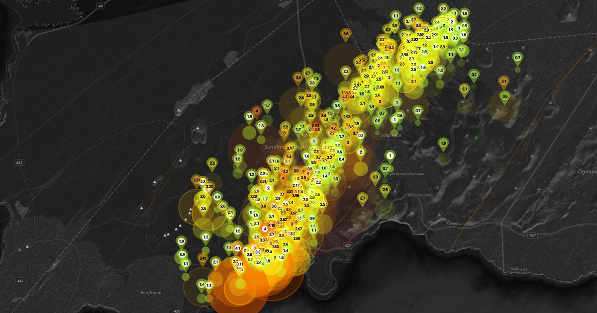
"Around five o'clock, it was decided to raise the civil defense alert level, and then we went to the danger level," says Víðir. This means that preparedness is increased. He says that the development was rapid after dinner, when data from the Met Office's measuring instruments, GPS data, satellite images and more were reviewed.

"Around ten o'clock, scientists began to interpret this so that it could not be ruled out that the magma tunnel could reach Grindavík."
The scientists' assessment and public safety advice were presented to the chief of police in Suðurnes, and the decision to evacuate was made as a result. "The advantage of this scenario is that we will have evacuated before the eruption begins," says Víðir. When asked, he says that the mentioned length of the magma corridor was the most surprising.

When asked how long the evacuation can be expected to last, Víðir says that it can last for several days.
"We need to keep a close eye on it. We know that the activity can move even if it starts to erupt in one place," says Víðir. He adds that even if it starts to erupt far from Grindavík, it is not certain that it will be possible to allow residents to Grindavík.
"We will evaluate it immediately," says Víðir.

Latest notice
(11 Nov 2023, 06.39 local Icelandic time)

Status unchanged after status meeting
The situation regarding the evacuation of Grindavíkurbær remains unchanged after the situation meeting of the coordination center and operational control at six o'clock, according to Hjördís Guðmundsdóttir, information officer for the civil protection.The town is now deserted after the civil defense called all responders out of Grindavík last night. The police are now manning closure posts at the farm.The next status meeting will be at 8 a.m. and then the Norwegian Meteorological Agency's scientists and the Norwegian Civil Defense will meet at 9:30 a.m. New data will then be reviewed.
END OF ARTICLES
(10-)11 Nov 2023 - 03:06 local Icelandic time
mbl.is also confirms that the town of Grindavík is being evacuated now. From the geological video i've heard that 3500 people live in that town. Here the article as follow:
Af hverju var Grindavík rýmd?
Það var ákvörðun lögreglustjórans á Suðurnesjum að rýma Grindavík í kvöld. Sú ákvörðun er tekin vegna ráðgjafar almannavarna. En hvers vegna?
Why was Grindavík evacuated?
It was the decision of the police chief in Suðurnesj to evacuate Grindavík tonight. That decision is taken as a result of the advice of the public defence. But why?Víðir Reynisson, Chief Inspector of Public Security, says in an interview with mbl.is that the decision was made following the advice of scientists.
"Then it took no time to make this decision and implement it," says Víðir.
The development is fast after dinner
Asked about the prelude, Víðir says that soon after noon the earthquake became powerful and that it became even more powerful as the day progressed."Around five o'clock, it was decided to raise the civil defense alert level, and then we went to the danger level," says Víðir. This means that preparedness is increased. He says that the development was rapid after dinner, when data from the Met Office's measuring instruments, GPS data, satellite images and more were reviewed.
The length was the most surprising
"When this was added up, people saw that there was every chance that a powerful and fairly large magma corridor was forming from these areas where the earthquakes were and in the direction of Grindavík," says Víðir."Around ten o'clock, scientists began to interpret this so that it could not be ruled out that the magma tunnel could reach Grindavík."
The scientists' assessment and public safety advice were presented to the chief of police in Suðurnes, and the decision to evacuate was made as a result. "The advantage of this scenario is that we will have evacuated before the eruption begins," says Víðir. When asked, he says that the mentioned length of the magma corridor was the most surprising.
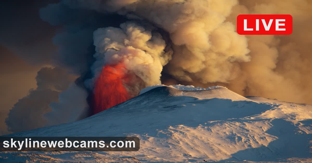
A question of hours rather than days
"It's not certain that it will be days, it could be because of tomorrow that this happens. The quakes have been very powerful and there are visible movements on the surface," says Víðir when asked if there is a chance of an eruption.When asked how long the evacuation can be expected to last, Víðir says that it can last for several days.
"We need to keep a close eye on it. We know that the activity can move even if it starts to erupt in one place," says Víðir. He adds that even if it starts to erupt far from Grindavík, it is not certain that it will be possible to allow residents to Grindavík.
"We will evaluate it immediately," says Víðir.
Latest notice
(11 Nov 2023, 06.39 local Icelandic time)
Status unchanged after status meeting
The situation regarding the evacuation of Grindavíkurbær remains unchanged after the situation meeting of the coordination center and operational control at six o'clock, according to Hjördís Guðmundsdóttir, information officer for the civil protection.The town is now deserted after the civil defense called all responders out of Grindavík last night. The police are now manning closure posts at the farm.The next status meeting will be at 8 a.m. and then the Norwegian Meteorological Agency's scientists and the Norwegian Civil Defense will meet at 9:30 a.m. New data will then be reviewed.
END OF ARTICLES