What's the weather where you are?

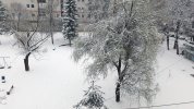
Most of Scotland seems to have been brought to a standstill with all the snow we have been having. The 2 major airports, Glasgow and Edinburgh, are closed, there are no trains and barely any buses running.
1000's of people were stuck overnight on the M80 motorway because of broken down and abandoned vehicles.

People are so ill prepared for this type of severe weather and a lot of people ignored the weather warning to try to travel which left them freezing in their cars without food, water or blankets. Luckily volunteers helped to bring supplies to people who were in need.

I'm in London at the moment and am watching the travel news and flight trackers to see if I will be able to get home (Glasgow) this evening. Fingers crossed they manage to clear the runways.

I'm following the news and there is a train trapped in Dorset with hundreds of people trapped on it and no power. They have been there overnight with many people without adequate clothing to keep them warm. The army have been drafted in to help people so hopefully they will be out soon!

I'm safe and well though and my flight provider will put me up in a hotel and transfer my flights free of charge so my thoughts are with all those poor people who aren't so lucky.

_https://www.express.co.uk/news/weather/926040/UK-Scotland-weather-forecast-beast-from-east-snow-school-closures
 
Yesterday it was a beautiful full,big and orange color moon in Oslo City.Temperature was around -10 and -15 C.colder,colder...Today is cloudy but still colder.We have temperatures under -10 and the moon is hidden.
 
Here in North Eastern US, another bombogenesis this year without much warning, Intense wind (50 to 60 mph), rain and snow (some ice too)in NJ, 18 inch snow in western NY state. We did lost power for 2 hours. I read there are 2 million houses without power today in NE US.
 
March 1st was the first 24 hour period in Denmark in March with below 0 C/32 F on all measuring stations for 12 years. Other than that the winter month from December to February have been slightly warmer than the decade from 06-15, with less precipitation and a few hours more sunshine. _http://www.dmi.dk/nyheder/arkiv/nyheder-2018/marts/her-er-tallene-saadan-gik-vinteren-i-din-kommune/ The cold at the end of February came as an abrupt change.


The ice sheet mass balance in Greenland is within the normal range and has been there most of the time since September _http://www.dmi.dk/groenland/maalinger/indlandsisens-massebalance/
 
Currently the temps at Bagnères-de-Bigorre, (Hautes-Pyrénées) is 10*C (50*F) and warming, under clear blue sky's.

Last Thursday local temp was a high of 18*Celsius (64.4*F).

No real snow fall at the moment on the ground. But a fair amount of snow pack on the higher foothills and the mountains.

We (this area) should have some snow on ground. But the few scattered showers (over the last 15 days), at this altitude are abnormally warmer since the last week of February. The last real snow fall was on the 17th of February but evaporated rather quickly over the followings days after.

There is currently a Yellow Warning for thunderstorms for the next 24 hrs. Very unusual for this time of year.
Also a Yellow Warning for Avalanches (associated with this current warming trend) in the higher mountainous areas.

Yellow Warning for Thunderstorms in effect until Wednesday, 6:00 AM CET. Source: Météo-France
_https://www.accuweather.com/en/fr/bagneres-de-bigorre/135472/weather-warnings-511332/135472
Although rather usual in this region, locally or potentially dangerous phenomena are expected. (such as local winds, summer thunderstorms, rising streams or high waves) Be aware and pay attention to the latest weather updates, especially if you carry out activities exposed to weather or close to a stream or shoreline.

Time delays between this website and the _www.meteoalarm.eu website are possible, for the most up to date information about alert levels as published by the participating National Meteorological Services please use _www.meteoalarm.eu
 
Just a brief follow up:
Yesterdays front moved in at about noon dropping a light powder of snow and rain.

The heavier snowfall is at the higher elevations. With light flurries being observed at the lower altitudes.

Ok then, stay safe.

Pic du Midi - Time - Lapse March 6, 2017 (00:40)
http://picdumidi.com/en/live/timelapse
 
seek10 said:
Here in North Eastern US, another bombogenesis this year without much warning, Intense wind (50 to 60 mph), rain and snow (some ice too)in NJ, 18 inch snow in western NY state. We did lost power for 2 hours. I read there are 2 million houses without power today in NE US.
Another Nor'Easter passed today, supposed to snow for 24 hrs to the totals of 6-12+ inches, but it ended up accumulating for the total of 5 inches due to high temperature and most of the time it looked it rained though flaking are falling. We lost power for 1.5 hrs again. It looks another Nor'Easter lurking for the early next week.
 
In the Netherlands, another record has been broken:

https://www.sott.net/article/380306-Coldest-March-17th-in-the-Netherlands-since-records-began
 
Palinurus said:
In the Netherlands, another record has been broken:

https://www.sott.net/article/380306-Coldest-March-17th-in-the-Netherlands-since-records-began

And on the same day sea water in the Wadden Sea was receding and the ferry to Ameland (one of the West Frisian Islands off the north coast of the Netherlands) got stuck. Other ferries to the island were cancelled this week-end.

https://www.nu.nl/231570/video/veerpont-naar-ameland-loopt-vast-op-waddenzee.html
 
Lots of rain, recent thunderstorms. Snow expected, but I think it will stay North of here as not very cold at the moment. Eastern NC.
 
The cold polar wave that came across the whole Europe can be felt in Macedonia too. This morning we had a 10 cm of snow and temperature of -3C at 8:30 in the morning. Weak north-east wind is blowing all the time so it makes feel even colder and it will snow in the next 2 days.
Forecasts are that is will continue like this until the end of the weekend and at some points, it can be mixed with rain or frozen rain.
At the mountains at the altitude of about 1700 - 2000m the snow cover is more than 1 m.

We have a polar spring this year. Strange weather.
 

Attachments

  • 1.jpg
    1.jpg
    1.3 MB · Views: 43
A sort of Blizzard conditions in Split&Dalmazzia tonight. Some pretty serious snowing accompanied with numerous gusts of Boorah. March turns out to became as whimsical as February - a first transgender month EVER! :O

:evil:
 
Here in Wisconsin we're experiencing a short return of Winter. Woke up to 3" of snow (up to 8" northern half of state) with temps below freezing and even blustery wind chills.
Oddly enough it is one of the few accumulating snowfalls we've had since last year when Winter began; it's been very dry with below average amounts of precipitation.
Temps in general were well below average for March, and April so far, and currently we're 30 degF below average for beginning of April.:shock:
Hope my emerging tulips and daffodils can hang on during this cold snap:-/
 
Weather is weird here in Dresden, East Germany. But it's somewhat in line with what we call 'April Weather', meaning very unsteady, sun and rain at the same time etc.
It became very warm suddenly the last two days (13°C right now). It just started to pour heavily just now, was sunny and calm 10 minutes ago.
But yesterday evening was a strange thunderstorm with very short (in time) lasting but very bright flashes that went horizontally across the sky, very wide range like 45° (of the 360° complete viewfield). Doesn't sound much but felt like going across the complete horizon. The lightnings didn't seem to go down to earth/surface, rather uncharging within the atmosphere. Also very high apparently, thats what it felt like, because a flash directly above was heard like 12 seconds later, the sound of flashes in the far took like 20 to 40 seconds. And on top of that two days ago I saw a fireball going very fast from west to east, glowing green/blue and dying. was the brightest/largest i have seen so far, gave me chills! I don't know if a single meteor could affect very local weather that much, but sky is weird since then.
google images for 'fireball blue green' shows pretty much what it looked like, but without the yellow/fiery part on some pictures. It was overcast that night, so i wondered that it was so bright, but the clouds could also make it look larger/brighter by scattering the light.
With the sudden pouring here i thought i could make use of this thread.
 
Strange weather here in Western Poland too: it was snowing shortly before Easter and the temperatures oscillated around 0 Celsius (32 F). Then Tuesday and Wednesday came with 18-20 degrees Celsius (64-68 F) and lots of sunshine. The change happenedover less than two days.

It's not entirely unusual though, there is a saying that April mixes winter and summer. Well, it certainly does feel like it: winter boots on Monday and short sleeve on Wednesday :-)
 
Back
Top Bottom